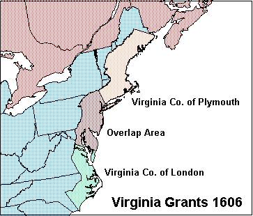
In 1607 two settlements were established in
“Virginia”. The London Company founded Jamestown in the
Chesapeake Bay area. The Plymouth Company established the Popham
Colony at the mouth of the Kennebec River in what is now Maine. After
a fierce winter the Popham settlement was abandoned. Thereafter the
Plymouth Company floundered and was eventually dissolved. Jamestown
did not fare much better. There was at least one attempt to abandon
the settlement. With the failure of Popham all efforts were directed
toward Jamestown despite appalling death rates and chronic financial losses.
In 1609, King James offered the London Company a generous
incentive. He granted the company a charter making Virginia a
province of England, with a hefty land grant to boot. This new grant
extended as far south as Cape Fear, (34th Parallel), and
north to Barnegat Bay, New Jersey, (40th Parallel).
Although this grant did not extend as far north as the original grant
of 1606, the London Company was given clear title to the entire
tract. Gone was the restriction of establishing settlements within
100 miles of the Plymouth Company towns. Also, the new grant extended
all the way across the continent to the Pacific Ocean. The southern
boundary extended due westward. The northern boundary extended in a
northwesterly direction. The grant of 1609 placed most of the present
day United States, as well as much of present-day western Canada
within the legal bounds of Virginia. This grant encouraged the
stockholders to invest still more treasure into the venture, and
Jamestown managed to barely survive.

By 1611, it seemed that Jamestown was a
failure. Virtually every settler died within a few years of arriving
in the colony. After four years, no gold or precious gems were
discovered. No crops or animals were found that could be exported
back to Europe for a profit. The discouraged investors were about to
give up on Jamestown. King James was determined to establish English
power in the new world however. He offered the London Company one
more incentive. A third grant was issued to the London Company. The
1611 grant was similar to the 1609 grant. It also extended “from
sea to sea”, but the southern boundary was relocated at the 29th
Parallel. Most of what is now the southern United States, as well as
northern Mexico was placed in Virginia. The island of Bermuda was
also included in the 1611 grant. At that time, there were more
settlers on Bermuda than Jamestown. The third grant was enough of an
incentive to keep the investors interested. By 1617, tobacco was
starting to generate enough profit to insure the survival of the
colony. Jamestown began to flourish and served as the capital of
Virginia until 1699. The period from 1611-1620 represented the
greatest territorial extent of Virginia during its four-century history.
Reductions during the Colonial Period
For thirteen years, Virginia was the only English colony on
the North American continent. All efforts of colonization were
focused on Jamestown. By 1619 the settlement had a good chance of
surviving. The first slaves were introduced that year, as well as the
first shipload of English maidens. The London Company created the
House of Burgesses to provide some measure of self-government. These
events induced still further colonization. It was then possible for
the English crown to begin expanding the empire to other parts of the continent.
Religious strife had troubled England since Henry VIII broke
with the Catholic Church in 1528. The Puritan movement began to
threaten the monarchy as it challenged the traditions of the Anglican
Church. In 1620, King James decided to establish a new colony in
America for the Puritans. Several Puritan leaders were receptive to
the idea. A Council for New England was established with the
expressed purpose of establishing a new colony that would be owned
and administered by Puritans. The Council was issued a royal grant of
all lands in America that lay between the 40th and 48th
Parallels. This new grant fixed Virginia’s northern border at
the 40th Parallel, from sea to sea. The act of 1620 was
the first of many territorial reductions that Virginia would experience.
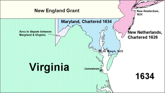
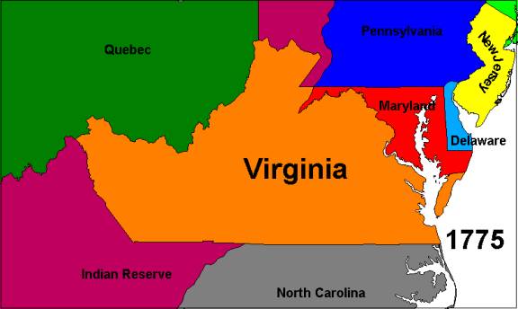
In 1632, King Charles I of England issued a grant to Lord Baltimore, for the portion of Virginia that lay north of the Potomac River, and a straight line across the Chesapeake Peninsula at Pocomoke Sound. The Lord Baltimore Grant was chartered as the Colony of Maryland in 1634. The creation of Maryland resulted in a second reduction of Virginia. Disputes concerning the exact boundary of Maryland arose almost immediately. The alignment across the Chesapeake Peninsula was contested first. By 1668, the dispute over the Eastern Shore boundary was resolved. The Potomac boundary also proved troublesome. From the river’s estuary to the mountains the boundary was clear. The controversy centered on the two main forks of the Potomac in the trans-Allegany territory. Maryland claimed the South Fork as the main stream, while Virginia claimed the North Fork. Maryland therefore claimed a considerable piece of what is now West Virginia. This dispute was resolved in Virginia’s favor as part of a special survey that determined the boundaries of the Lord Fairfax Grant in 1746. The Commissioners determined that the North Fork of the Potomac was the main stream and therefore the true boundary between Maryland and Virginia.
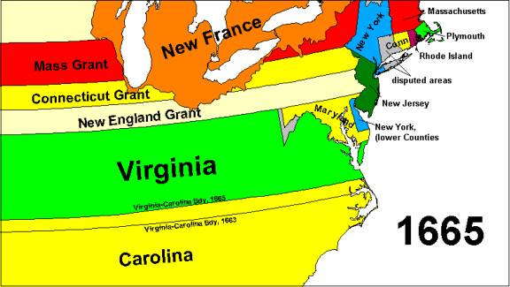
A third major reduction occurred in 1663. In that year, King
Charles II of England issued a colonial grant for Carolina. It
included the portion of Virginia south of the 36th
Parallel. Virginia was reduced to a latitudinal band across the
continent extending from the 36th to the 40th
Parallels, excepting Maryland. Virginia was further reduced two years
later when the Carolina-Virginia border was moved northward by half a
degree of latitude. This boundary adjustment was made so that all of
Albemarle Sound would lie within Carolina. At that time there was no
direct communications link between Chesapeake Bay and Albemarle
Sound. Travel between settlements on these two water bodies were
further hampered by the Great Dismal Swamp, which lies directly
between them. It was decided that the swamp itself would make a
logical location for a boundary. Latitude 36°
30’ was therefore chosen as the Carolina-Virginia boundary. The
reduction of 1665 finalized the northern and southern boundaries of
Virginia during the colonial period.
Virginia was directly involved in the French and Indian War. While a captain in the Virginia militia, George Washington, was dispatched to expel the French from Ft. Duquesne in 1753. Based on its colonial grants, Virginia claimed the Ohio Valley. The French were by then active in establishing a series of forts and trading post throughout their Louisiana Colony. In 1753, the Ohio Valley was considered to be part of Louisiana by the French, because the Ohio is a tributary of the Mississippi River. Washington failed to persuade the French to leave. A second expedition in 1754 led to bloodshed, triggering the war. France ultimately lost all of its North American empire. Louisiana was partitioned between Spain and Great Britain right down the Mississippi in 1763.
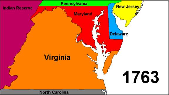
With the French out of the Ohio Valley, the way was opened for Virginian expansion into that valley. The British monarchy had different plans for the region however. King George III did not wish to see any more bloodshed in Indian territory. The war had been costly in terms of both blood and money. He decided to freeze the frontier at the Allegany Mountains. The Proclamation of 1763 prohibited any further settlement west of the Allegany. This act reduced Virginia once more. The Proclamation generated deep resentment in Virginia and other colonies, sowing the seeds of the coming revolution. Virginia was permitted to expand westward in the years following the Proclamation of 1763, however. The crown recognized the fact that most of the territory to the west of Virginia’s mountains were by then vacant of Indians. In 1769, the Vandalia Company was established. Its tract occupied what is now West Virginia and southwestern Pennsylvania. Since Virginia chartered Vandalia, the colony effectively extended its territory westward to the Big Sandy and Ohio Rivers. The creation of the Transylvania Company in 1775 extended Virginia as far west as the Kentucky River.
The Revolution Affects
Virginia’s Boundaries
The Colony of Quebec was established by Great Britain as part
of the Proclamation of 1763. The French-speaking colony was initially
limited to the St. Lawrence valley. In 1774, Parliament enacted the
Quebec Act, greatly enlarging the territory of Quebec to include the
entire Great Lakes Basin and the Ohio Valley north of the River.
Though the Quebecois were by then British subjects, the colonists
along the Atlantic seaboard still considered them to be adversaries.
They bristled with resentment that their old enemies once again
controlled the highly coveted Ohio Valley. The fact that their own
government had mandated the handover of a vast and valuable territory
to the Quebecois was indeed a bitter pill to swallow. Nowhere was
that bitterness felt more than in Virginia. The passage of the Quebec
Act was the catalyst that prompted the convention of the First
Continental Congress in 1774.
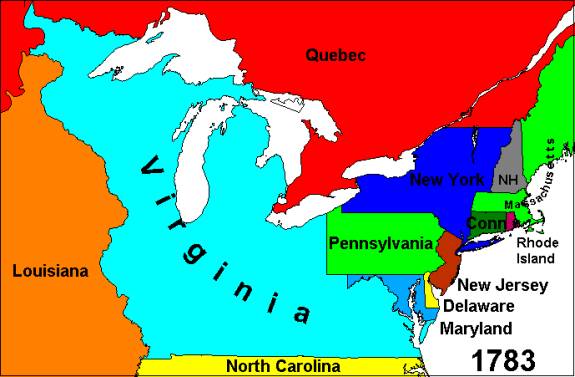
When the Second Continental Congress ratified the Declaration
of Independence in 1776, it called upon the thirteen original states
to draft new constitutions. Virginia quickly adopted a constitution,
and took advantage of the opportunity to reclaim some of its lost
territory. Virginia extended its claims westward to the Mississippi
River, and northward to the southern limits of the Hudson Bay
Company, (Rupert’s Land). This claim encompassed most of the
territory that had been granted to Quebec just two years before. The
brilliant campaign of 1778, led by George Rogers Clark secured the
Ohio Valley for Virginia, as well as for the United States.
During the subsequent peace negotiations, John Adams insisted
that the Mississippi River be recognized as the western boundary of
the United States. Not wishing that the trans-Allegany region fall
into French or Spanish hands, Britain conceded. In return, the United
States was forced to relinquish all claims north of the Great Lakes.
Virginia was bound to accept Lake Superior as its northern boundary,
but was still left with a territory as large as Texas and California
combined. Virginia, always the largest of the thirteen colonies had
established itself as the largest of the thirteen states.
But pressure was mounting against Virginia with regard to its
vast territorial claims. Maryland refused to ratify the Articles of
Confederation until the states with large western land claims
surrendered them to the new national government. In 1781, New York
ceded all of its claims west of Lake Ontario to the United States.
The Virginia Assembly voted to cede at least some of its western
territory to the United States, once Congress had established a
process for creating new states in the region. Satisfied with these
actions, Maryland ratified the Articles of Confederation. The United
States then had a new government.
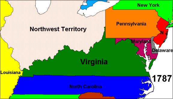
One of the major challenges facing the new government was resolving several territorial disputes between the states. Virginia claimed southwestern Pennsylvania as part of its Vandalia annexation. The issue was submitted to Congress for arbitration. Virginia accepted the ruling that went in favor of Pennsylvania. The Mason-Dixon Line was accepted as Virginia’s northern boundary from Maryland’s western boundary, as far west as the western boundary of Pennsylvania.
With peace secured in 1783, the Confederation Congress set about developing a method of establishing new states in the west. A program of western development was outlined, based on a plan put forth by Thomas Jefferson. Virginia took the next step by ceding all of its territory north and west of the Ohio River to the United States in 1784. The greatly reduced commonwealth encompassed what are now the states of Virginia, West Virginia, and Kentucky. The Virginia cession was followed by cessions made by North Carolina in 1784, Massachusetts in 1786, Connecticut and South Carolina in 1787, Connecticut, (Western Reserve), in 1800, and Georgia in 1802. Following the Connecticut cession of 1787, Congress enacted the Northwest Ordinance, establishing the Territory Northwest of the River Ohio. Comprising the area that had been ceded to the United States by Virginia in 1784, the Northwest Territory was the first federal territory ever to be established by the United States. The states of Ohio, Indiana, Illinois, Michigan, Wisconsin, and part of Minnesota were eventually created from this area.
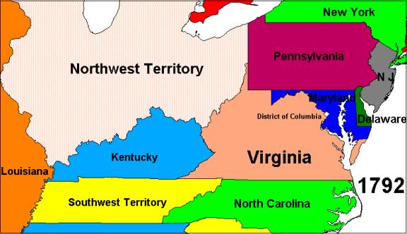
At the outbreak of the American Revolution, large numbers of
Virginia settlers began migrating through the Cumberland Gap into
what is now Kentucky. In 1776, Virginia organized a new Kentucky
County, encompassing the area of the present day state. By 1789,
Kentucky County had been subdivided into nine new counties, none of
which was called Kentucky. Collectively, these nine counties were
known as the Kentucky District of Virginia. A new society was rapidly
emerging in this frontier backcountry. Geographic isolation, and
economic orientation to the Ohio and Mississippi Rivers spawned a
statehood movement in the region. The Virginia General Assembly voted
to grant Kentucky statehood in 1789. Congress passed an enabling act
in 1791, and Kentucky entered the union the following year. Virginia
was reduced to the area of the present states of Virginia and West
Virginia. The Cumberland Mountains and Big Sandy and Ohio Rivers then
formed the western boundary of Virginia.
Virginia also voted to grant the new federal government a one hundred square mile tract of land on the Potomac River for the Federal City in 1789. In 1791, President Washington issued a proclamation establishing the boundaries of the Territory of Columbia. Thirty-one square miles of Virginia were included within the capital territory. In 1801, the territory was redesignated as the District of Columbia. The Virginia portion was organized into a county named Alexandria. (The Maryland portion was organized as Washington County). In 1846, Abraham Lincoln was elected to Congress from Illinois on a campaign plank that called for the abolition of slavery in the District of Columbia. The slave holding residents of Alexandria feared that Lincoln’s proposal would be approved. They organized a referendum calling for the retrocession of Alexandria County back to Virginia. The referendum passed, and Congress gave its consent. Alexandria County now consists of Arlington County and part of the City of Alexandria. Congress abolished the slave trade in the District of Columbia as part of the Compromise of 1850. President Lincoln abolished slavery entirely in the District during the Civil War.
The Admission of West Virginia
The final chapter of the evolution of Virginia’s
boundaries involves West Virginia. Only four states were created
directly from existing states: Vermont from New York in 1791,
Kentucky from Virginia in 1792, Maine from Massachusetts in 1820, and
West Virginia from Virginia in 1863. Like Kentucky, the residents of
western Virginia were geographically isolated from Richmond and
economically oriented to the Ohio Valley. The narrow shaded valleys
of the trans-Allegany region precluded large plantations and
discouraged slavery. The eastern plantation powers refused to invest
the state treasury in western internal improvements, which inhibited
economic development. They also refused to establish a public school
system. The western counties were unable to change the situation in
Richmond, because the reapportionment process favored counties with
large slave populations. Slaves were counted as whole people for the
purposes of apportioning the legislature, but of course they could
not vote. Thus the western counties were at a terrible political
disadvantage. They could do virtually nothing to change their
economic situation. This unfavorable condition led to a statehood
movement as early as the 1820’s.
When Virginia seceded from the union in 1861, most of the
delegates to the secession convention who represented western
counties voted against secession. These delegates held their own
convention in Wheeling. They established a restored government of
Virginia. The restored government elected a governor, two US
senators, and three US representatives. Wheeling was selected to
serve as the provisional capital. Congress and President Lincoln
recognized this government, and hoped to make it a model for other
Confederate states seeking readmission after a union victory. The
restored government, now controlled by western Virginians, took
advantage of the unique political situation to create a new state.
They voted to grant the western counties the right to establish a
state called Kanawha in 1862. A constitutional convention changed the
name of the proposed state to West Virginia. It also provided for
slavery. This provision was included to gain the support of several
western counties that had voted in favor of secession. Congress
objected to the slavery provision. A second convention was held which
modified the original constitution. This new charter provided for the
gradual abolition of slavery.
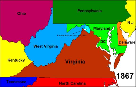
Fixing the boundaries for the new state was difficult. Indeed, settling on the boundaries was the most challenging issue facing the state’s founders, even more so than slavery. The new state had to balance the desire for political cohesion against those of security in light of the ongoing war, which was being waged in and around western Virginia. Of grave importance was the need to keep the Baltimore and Ohio Railroad within union hands. This vital rail link was the only direct railway connecting Washington with the western states. There was the possibility that the Confederacy might win the war, and the north wanted to be sure that the B&O remained within the United States after a peace had been negotiated, should that be necessary. It was decided therefore, that the Potomac counties as far east as the Harper’s Ferry crossing be included within the new state. Other counties were included because they controlled key mountain passes through the Allegany. Some counties were given the option of joining the new state. In the end Congress approved of a state consisting of 48 counties. Jefferson, Berkeley, and Frederick Counties were given the option of joining the new state after Confederate control had ended. West Virginia entered the Union in 1863. Following referendums in 1866, Jefferson and Berkeley Counties were transferred to West Virginia, effective in 1867. Frederick County never held a referendum. The transfer of the two eastern panhandle counties, represents the final boundary adjustment in Virginia’s history.
Conclusion
Virginia was the first of the thirteen original colonies to be established. It experienced both expansion and contraction throughout its history. Once claiming most of the United States, Virginia has been gradually reduced to a medium-sized state. It is now roughly triangularly shaped. Virginia is bounded on the north by Maryland and the District of Columbia, on the west by West Virginia, on the southwest by Kentucky, and on the south by Tennessee and North Carolina. The Atlantic Ocean, rivers, mountains, and a parallel of latitude form its boundaries. Virginia is a state of varied topography. It encompasses a coastal plain that is flooded by the Chesapeake Bay. It includes part of the Piedmont upland, several parallel linear mountain ranges, and an elevated plateau. Rivers flowing to the east, north, south and west drain Virginia. It straddles both the Atlantic and Mississippi watersheds. The Old Dominion encompasses these varied physiographic provinces because its boundaries delineate a territory whose history is rich in the American experience. Virginia can be compared to a pie that has been gradually cut down through its four-century period of evolution.
References
Boundaries of the United States and the Several States, Professional Paper 909, US Geological Survey, 1976
The Cartography of North America 1500-1800, Portinaro & Knirsch, Crescent Books, 1987
Virginia Places