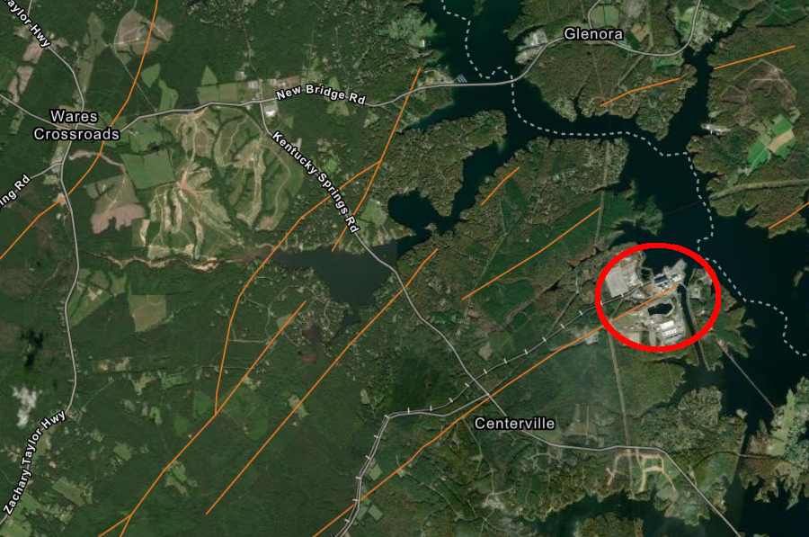
faults (brown lines) cut through the Piedmont bedrock at the North Anna Power Station and nearby
Source: ESRI, ArcGIS Online
faults (brown lines) cut through the Piedmont bedrock at the North Anna Power Station and nearby
Source: ESRI, ArcGIS Online
Geologic faults are a zone of weakness within bedrock. Mapping the location of faults accelerated in the 1960's and 1970's when sites were being chosen for constructing nuclear power plants.
Faults increase risks; bedrock which moved in the past might move again in an earthquake, potentially cracking the containment vessel and releasing radioactivity. Identifying locations of "solid" bedrock without a fault reduced risk of a nuclear incident.
In the United States, only one nuclear power plant was built on top of a fault. The Virginia Electric and Power Company (VEPCO), now Dominion Energy, concealed the discovery of a fault when getting a license for Units 1 and 2 of the North Anna Power Plant.
The Atomic Energy Commission granted the Federal licenses in 1973, but a local geologist shared his knowledge with the North Anna Environmental Coalition. He knew the fault was there, and that the utility was aware of it, from a site visit in 1970 after a construction excavation wall for Reactor Unit 1 collapsed. VEPCO had purposely deleted a required reference to the geologic fault before submitting licensing information to the Atomic Energy Commission.
That organization publicized the existence of the fault, and enlisted the help of the Virginia Attorney General's office. Two years later, the US Nuclear Regulatory Commission (successor to the Atomic Energy Commission in 1975) fined the utility company for making a "material false statement" during the license process.1
Only civil penalties were imposed, because the staff of the Atomic Energy Commission/Nuclear Regulatory Commission had also helped to delay revelation of the fault.
The fault was unknown when the site was chosen and construction started on Unit 1. In 1970 a chlorite seam was exposed during excavation. The construction company's chief geologist did not classify the chlorite seam as a fault, concluding that there was no evidence of geologic offset. The construction company decided the seam was caused by weathering.
Three independent geologists who visited the excavation judged the seam to be evidence of earth movement. It was not until 1973 that further excavation for a planned Unit 3 revealed there had been six-ten feet of displacement at the chlorite seam.
Even then, an outside consultant hired by VEPCO disagreed with the construction company's geologists who had concluded that the seam marked the location of a fault. The outside consultant:2
Other geologists for the outside consultant determined that they had discovered a fault, and rejected proposals to refer to it as a "shear" or other terms that would not trigger the same close Federal review once a "fault" was identified. However, the paperwork submitted for the Atomic Energy Commission to authorize construction of Units 1 and 2 did not mention the discovery of a fault at the site.
It appears the utility officials were concerned that opponents of the nuclear reactors would delay award of the Federal licenses. The Virginia Electric and Power Company (VEPCO) obscured the discovery in order to get enough time to document that the fault was not "capable."
"Capable" was a regulatory term of great significance. Faults at or near the ground surface were classified as capable of new movement, and thus a threat to a nuclear power plant, if the ground had moved at least once within the past 35,000 years or if movement of a recurring nature had occurred within the past 500,000 years. A fault could also be defined as capable if it had not moved within 500,000 years, but was associated with other capable faults.
A fault would be judged "not capable" and not considered to be a threat, if the land had been stable for a long period of time:3
The bedrock at the North Anna Power Station is part of the Ta River Metamorphic Suite, dating back to the Cambrian. That bedrock was accreted to Virginia as part of the Chopawamsic Terrane, an Ordovician volcanic-plutonic arc complex added to the edge of Virginia during the Taconic orogeny. If the last displacement at the chlorite seam dated back to the formation of Pangea or to its breakup, then the fault was too old to be classified as "capable."4
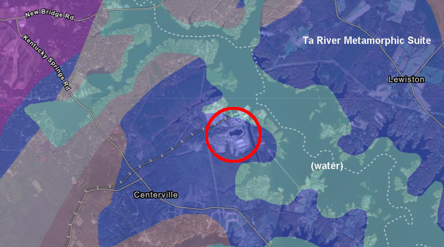
the North Anna Power Station (red circle) is located on the Ta River Metamorphic Suite, within the Chopawamsic Terrane
Source: Virginia Department of Energy, Geology Mineral Resources
Units 1 and 2 went online in 1979 and 1980. In 2001, the epicenter of a 5.8 magnitude earthquake was 11 miles to the southwest near the town of Mineral. Both units shut down, and the Nuclear Regulatory Commission allowed a restart 80 days later. The reactor containment buildings were built to withstand shaking equal to 12% of the force of gravity. The intensity of the earthquake exceeded the plant's design, but for only about three seconds. Only minor damage occurred at the North Anna Power Station.5
The most significant impact was the shifting of spent fuel casks. They were designed to stay in place during the maximum forces predicted during an earthquake at the North Anna Power Station, in order to maintain the required separation between containers of hot radioactive waste. Sensors at the site documented that those forces were exceeded briefly in 2011.
The older model TN-32 casks slid on the concrete pad during the Mineral earthquake, but the shift in position did not create a safety risk. The Nuclear Regulatory Commission reported:6
After the 2011 earthquake, the Nuclear Regulatory Commission considered the seismic risks for a proposed Unit 3:7
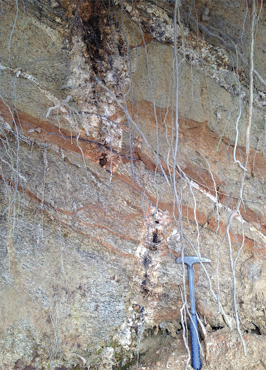
pegmatite dike offset by about three feet due to movement along a fault near the North Anna Power Station
Source: US Geological Survey (USGS), Geologic Framework for Seismic Hazards in Central Virginia