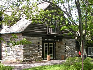
 Big Meadows Lodge, in Shenandoah National Park |
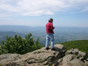 looking at Page Valley and Massanutten Mountain | 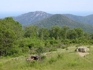 Old Rag Mountain |
Big Meadows Lodge, in Shenandoah National Park |
looking at Page Valley and Massanutten Mountain | Old Rag Mountain |
Virginia is filled with "special places" that have significance for the whole country, not just for individuals, counties, or even the state. The Federal government has identified a few places in Virginia as worthy of Federal designation of one sort or another.
Some places have been designated as a National Forest, administered by the US Forest Service in the US Department of Agriculture. Others have been designated as a National Wildlife Refuge, administered by the US Fish and Wildlife Service in the Department of the Interior.
The two National Forests in Virginia are located in the western part of the state. After timber companies abandoned land there a century ago, erosion and floods downstream threatened the navigability of rivers. Minimizing excessive stormwater runoff to protect interstate/international commerce provided enough legal justification for the Federal government to purchase the private land, establish Federal forests, and restore the vegetation now covering mountain hillsides.
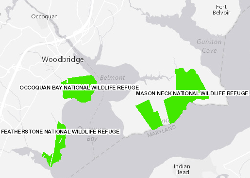
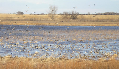
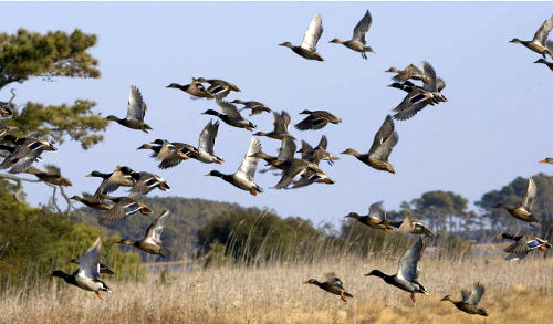
The US Fish and Wildlife Service focuses on waterfowl restoration. It has acquired wetlands within the Coastal Plain where ducks and geese spend the winter. In the spring, the waterfowl fly north to Canada, where they reproduce. In the fall migration back to coastal habitats in Virginia and points south, hunters who have purchased Federal Duck Stamps have more opportunities to shoot ducks/geese Through the purchase of the special duck stamps, hunters have provided the funding for purchasing habitat and increasing the waterfowl population.
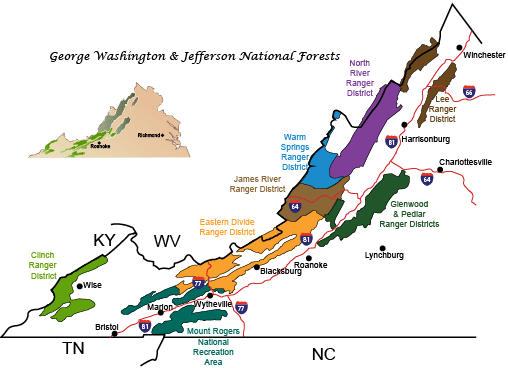 National Forests are divided into Ranger Districts, for local administration Source: George Washington and Jefferson National Forests, Mountain Biking |
Virginia even has one National Estuarine Research Reserve, serving as a baseline of environmental change for freshwater-saltwater marshes on the York River estuary. The four different parts of that "reserve" are managed by the National Oceanic and Atmospheric Administration (NOAA) in the Department of Commerce, the Chesapeake Bay National Estuarine Research Reserve that preserves diversity of coastal ecosystems.
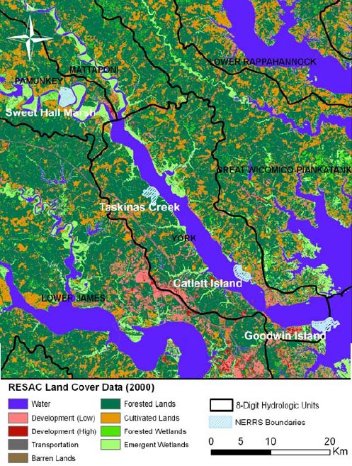
Chesapeake Bay National Estuarine Research Reserve units (Sweet Hall Marsh, Taskinas Creek, Catlett Island, and Goodwin Island) totaling 3,072 acres on Pamunkey and York rivers
Source: Chesapeake Bay National Estuarine Research Reserve in Virginia Management Plan: 2008-2012
Most tourists are aware of the areas designated as National Parks, or other names for units of the National Park Service - which is another part of the US Department of the Interior, and thus a "sister" bureaucracy of the US Fish and Wildlife Service.
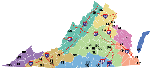
Places in Virginia managed by the National Park Service include major portions of the Blue Ridge (in the Blue Ridge Parkway and Shenandoah National Park), the sand dunes where English colonists first touched land in 1607 (at Cape Henry National Memorial), the battlefield in Yorktown where the British Army surrendered to the combined army of the French and the American rebels in 1781 (part of Colonial National Historical Park), Civil War battlefields from the beginning in 1861 to the end in 1865 (Manassas National Battlefield Park to Appomattox Court House National Historical Park), the birthplace of a slave who went on to scandalize Washington society by dining with a president and to lead Tuskegee Institute to greatness (Booker T. Washington National Monument), and a national park in the southwestern corner of Virginia through which settlers migrated west (Cumberland Gap National Historical Park).
which park unit at the far tip of Southwestern Virginia is missing from this map of National Park Service units in Virginia?
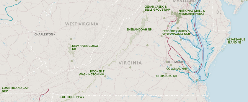
Source: National Park Service
The US Congress designated most units of the National Park Service, and they are not all called "parks." The different types of designations offer a clue about what made those places so special that they are maintained at the expense of taxpayers in all 50 states.
Places managed by the National Park Service go by more names than just national park. Official names include national seashore, parkway, national historical park, national battlefield park, and national historic site. The most recent additions involving Virginia are the Captain John Smith Chesapeake National Historic Trail (designated in 2006) and Fort Monroe National Monument (designated in 2011).
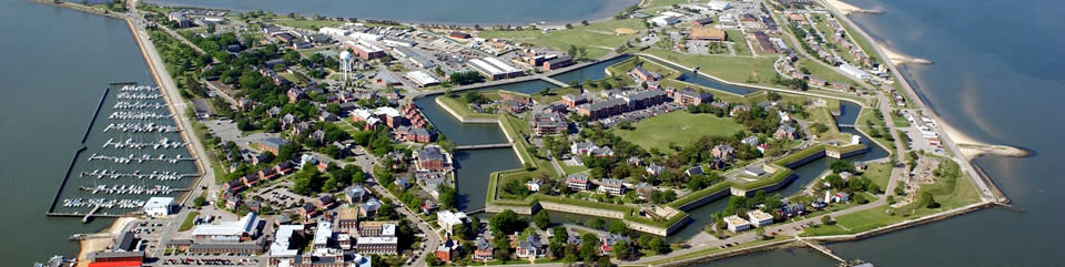
Fort Monroe National Monument was established in 2011, after the Base Realignment and Closure (BRAC) process moved the U.S. Army Training and Doctrine Command to Fort Eustis
Source: National Park Service, Fort Monroe National Monument
There is even one unit in Virginia managed by the National Park Service called Prince William Forest Park, which might cause visitors to think the place was managed by the Forest Service in the separate Department of Agriculture. Don't be confused; the "forest park" is managed by the National Park Service.
That Federally-owned park was started during the Great Depression of the 1930's as the Chopawamsic Recreational Demonstration Area, then renamed Chopawamsic National Capital Park in 1940. It was used to train spies in the Office of Strategic Services (which became the CIA after World War II), and finally given its current title in 1948.
Prince William Forest Park is near Quantico in Northern Virginia, where a high percentage of residents have worked for the Federal government and understand the distinctions between different agencies and how Federal, state, and local funding comes from different taxes. Efforts by the National Park Service to rename the unit "Chopawamsic National Recreation Area" have been blocked by local opposition.
Local officials are not concerned about changing the "Forest Park" half, but insist upon retaining "Prince William" in any future name. There is prestige, and perhaps some tourism business, associated with having a National Park Service unit include the county's name.
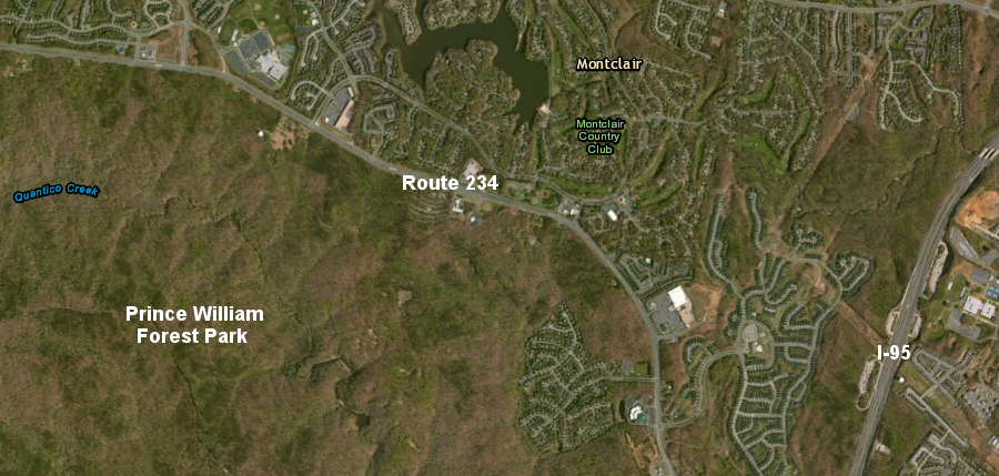
as a national park, the land in Prince William Forest Park is undeveloped - in clear contrast to nearby subdivisions
Source: ESRI, ArcGIS Online
About 20 separate parks in Virginia are special enough to qualify for a national designation. Breaks Interstate Park was judged to be not significant enough in the 1950's, despite its unspoiled and rugged terrain. Kentucky and Virginia recognized the benefits of conserving the site to attract tourists, so the two states created a bi-state commission that manages Breaks Interstate Park.
State-significant places have been included in the Virginia state park system, which started with 6 parks in 1936 and totaled 36 parks in 2013. According to Virginia State Parks, "there's at least one park within an hour's drive of any Virginian."1
Various local communities have local parks. The funding arrangements for supporting Federal/state/local parks are different - and the way those places are managed also differs.
Counties and cities get most of their discretionary funding for managing county parks from property taxes and user fees fees paid by golfers, families visiting a waterpark, members of organized athletic leagues, etc.
The Commonwealth of Virginia collects no property taxes. Instead, it relies primarily upon state income taxes and sales taxes, which the General Assembly allocates in a biannual budget to fund state parks. The state parks also generate funds from entrance fees. Virginia was the first state to create a system of state parks, when the first six units were opened in 1936, but park supporters highlight how funding has been inadequate to maintain or expand the system adequately. In 2005, the Department of Conservation and Recreation noted in a report on fees:2
state parks are managed as a system, separate from Federal parks, forests, wildlife refuges - and differently from state forests, wildlife management areas, and natural area preserves as well
Source: Virginia State Parks
The Federal government does not impose property or sales taxes. Federal units, including national parks, national forests, wildlife refuges, and estuarine reserves are funded more by Federal income taxes, plus entrance fees.
At all levels of government, some or all of the user fees are recycled back to the park where the fee was collected. (The typical percentage for Federal facilities is 80%.) For sites with entrance fees or user fees, the people who visit a park or take advantage of a particular activity end up paying a little extra for management of the place.
The US Fish and Wildlife Service and the National Park Service are both part of the Department of the Interior. The Department of the Interior is a separate department in the Federal government from the Department of Agriculture, which is the home of the US Forest Service. The Department of Commerce is a third agency with responsibility for managing natural areas. The US Army includes the Corps of Engineers, which manages recreational lake such as Kerr (Buggs Island) Reservoir on the Virginia/North Carolina border.
Different agencies have different philosophies and different regulations. The bureaucratic distinctions between park management agencies create some significant differences in management policies.
For example, as a result of these bureaucratic turf boundaries, national forests are managed by different officials than national parks. Some activities permitted in national forests are prohibited in national parks.
Trees are harvested commercially in national forests for paper and lumber, but commercial tree harvesting is not permitted in units managed by the National Park Service. If hikers see an interesting rock glistening on the trail in a national forest, they can pick it up and take it home - but in a national park, visitors can "take nothing but pictures and leave nothing but footprints."
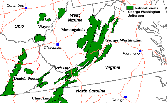
to reduce administrative overhead costs, the two national forests in Virginia (George Washington National Forest and Jefferson National Forest) are managed by one supervisor based in Roanoke, but each forest has a separate management plan
Source: US Forest Service
Wildlife is also managed differently, depending upon the government organization that owns the land. National forests and national wildlife refuges encourage hunting as a recreational use, but most national parks forbid hunting. (Fishing is allowed in most national parks, however.)
State - not Federal - agencies control wildlife populations and issue hunting/fishing licenses. To ensure state agencies would always support hunting/fishing/trapping, Virginia voters approved a ballot initiative in 2000 to add Section 4 to Article XI of the Constitution of Virginia:
There are, of course, some overlaps between state and Federal responsibilities. States must comply with Federal regulations that define some limits on seasons and "bag totals" for harvest of migratory wildfowl, since a migratory bird treaty was signed with Canada to manage the species that fly across international boundaries. States may not allow hunting/fishing/trapping of species on the list of threatened and endangered (T&E) species, as defined by the Endangered Species Act. In addition, Federal agencies may impose extra fees for accessing or hunting/fishing on Federal lands.
In legal theory, the public owns the wildlife that lives on private as well as public property - wildlife is not "owned" by the landowner, and private landowners must comply with state hunting and fishing regulations. Landowners can not hunt deer or ducks out of authorized hunting seasons, except that some farmers can obtain special authorization for animal damage control. Bears that continually raid a beekeepers hives, or deer that feed excessively on crops, may be killed out of season and above standard harvest levels in order to protect agricultural activities. (Another exception: the state does not enforce game laws on the two Native American reservations in King William County.)
Landowners still control access to their land; the right to hunt/fish/trap publicly-owned wildlife does not include the right to go on private land. Landowners can post No Trespassing signs to limit the public's hunting/fishing opportunities on "posted territory."
Hunters are not allowed to hunt on any private property without landowner permission; the right to hunt does not include the right to trespass. Similarly, the right to fish can be constrained by access to fishing sites, as demonstrated by "Kings Grant" lawsuits on the Jackson River. One exception: hunters in Virginia are allowed to ignore "Posted - Keep Out" signs and go on private land to retrieve their hunting dogs, because even a well-trained dog can't read signs.
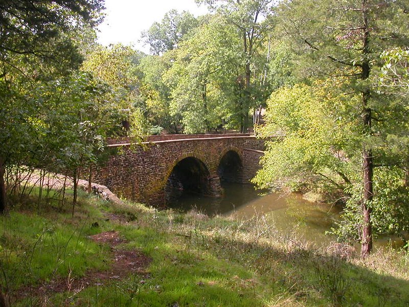
Stone Bridge at Manassas National Battlefield Park
(where there is no hunting allowed, despite an excessively-large deer herd damaging the vegetation)
Public agencies can also limit hunting/fishing/trapping on their lands, a common practice at military bases. Different Federal agencies impose different constraints. In Virginia, you can hunt deer, bear, grouse, and other game animals in the national forests. However, you can't hunt in units managed by the National Park Service (such as Cumberland Gap National Historical Park or the Blue Ridge Parkway).
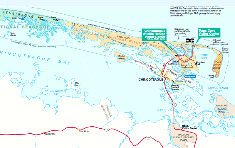
Assateague National Seashore and Chincoteague National Wildlife Refuge have different management philosophies for the same island, with the Maryland/Virginia border defining the key boundary between the National Park Service and US Fish and Wildlife Service lands
Source: National Park Service
Another major Federal landowner in Virginia is the US Fish and Wildlife Service - and yes, you can hunt at a wildlife refuge managed by the US Fish and Wildlife Service. Many of the refuges were established using money provided when hunters purchased an additional Federal Duck Stamp to go with their state hunting licenses.
Hunters were early conservationists, recognizing the need for habitat preservation. They knew that large tracts of wetlands and wintering grounds needed to be kept in their natural condition, not drained for agriculture or developed for waterfront housing, to ensure waterfowl would have enough land/water to reproduce. Wildlife refuges help provide an abundance of birds for hunting.
That's why wildlife refuges managed by the US Fish and Wildlife Service are not maintained in a pristine state. Some are actively farmed, to grow enough wild food for the overwintering waterfowl populations. At many refuges along the Atlantic Flyway, where ducks/geese/swans migrate south from nesting grounds in Canada to spend the winter in Delaware-South Carolina, refuge managers actually manipulate the flow of water and the growth of vegetation in ponds and "moist soil management areas." In particular, refuges on the Eastern Shore and Back Bay National Wildlife Refuge are designed and managed to "grow ducks" for hunters.
Refuge managers drain the moist soil management areas and plant crops preferred by waterfowl (such as millet). In the Fall, instead of harvesting the crops, refuge managers re-flood the moist soil management areas. The water depth in the Fall makes a difference. Some ducks dabble only near the surface for food, while others will dive several inches deep. Water level is adjusted in different areas to generate enough wild food for the intended species.
In contrast, National Park Service units try to mimic natural processes, and minimize manipulation of the landscape except except when needed to restore natural conditions (in parks managed to maintain the natural setting) or historical conditions (in parks managed primarily for their historic value).
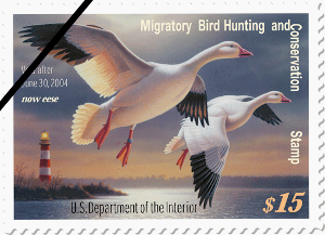
the 2003-2004 Federal Duck Stamp included the Assateague Lighthouse behind the snow geese
Source: US Fish and Wildlife Service, Federal Duck Stamp
You can't pick flowers or take home a rock from a National Park Service site. You can't chop down live trees for a campfire. Don't expect to see a commercial timber sale in Prince William Forest Park - despite its name, it is a unit of the National Park System. Don't plan to hunt the over-abundant deer at Manassas National Battlefield Park.
However, recreational fishing is allowed in most units of the national park system. Bambi may be too cute to hunt in national parks, but the fish get less protection.
To repeat: what is allowed for recreation is based on the reason land/water was protected in the first place. You can use your state-issued deer tag in the George Washington National Forest managed by the US Forest Service in the Department of Agriculture because that forest was intended for multiple use management from the beginning. You may hunt waterfowl, deer, and other game animals on wildlife refuges managed by the US Fish and Wildlife Service; recreational hunting is a legitimate recreational activity on those lands. However, you may not hunt in Shenandoah National Park managed by the National Park Service in the Department of the Interior, because that park was created to allow natural processes to dominate and human interference is minimized.
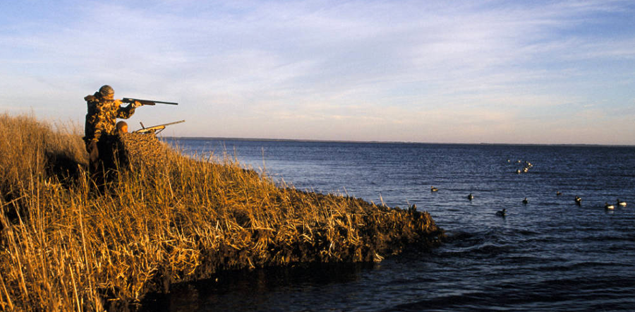
most land acquisition for wildlife refuges in Virginia was funded by hunters who purchased Federal Duck Stamps
Source: US Fish and Wildlife Service National Digital Library, Duck Hunting
You can hunt ducks and geese at Chincoteague National Wildlife Refuge managed by the US Fish and Wildlife Service, but not at the Yorktown battlefield in Colonial Historical Park managed by the National Park Service. Both of those bureaucracies are in the Department of the Interior, but different public agencies (Federal, state, local) have different management policies and recreational activities are shaped by the different missions of those agencies.
at wildlife refuges, US Fish and Wildlife Service officials raise food for ducks, geese, and other wildlife by creating artificial ponds and raising/lowering water levels, through "moist soil management" practices
Source: US Fish and Wildlife Service
Chincoteague National Wildlife Refuge provides habitat to waterfowl, to support hunting as a recreational activity
Source: US Fish and Wildlife Service
Why the different regulations? We set aside public places for different purposes, and established different agencies to manage those places in different ways. You won't find a baseball field or a golf course in Shenandoah National Park or Chincoteague National Wildlife Refuge, but you might in a county park.
Even the road and parking lot at Chincoteague National Wildlife Refuge, built so tourists can swim in the Atlantic Ocean, is controversial. Every time a storm damages the infrastructure, the US Fish and Wildlife Service objects to rebuilding it. Cost is one issue, but the agency's mission is an institutional barrier that frustrates the officials and business leaders in the Town of Chincoteague.
The US Fish and Wildlife Service mission includes support for recreational activities - but only wildlife-dependent recreation, such as birdwatching or hunting. Swimming for fun is not on the list. The agency struggles to explain during budget battles why it is so rich, it can afford to spend money to support activities beyond its mission.
In Virginia, management of the state parks is currently tilted towards the Federal style, with few facilities besides campgrounds, boat ramps, trails, and picnic shelters. However, the West Virginia state parks have been developed as resorts with fancy lodges. Proposals to use state park land for a golf course at Occoneechee State Park on Kerr Reservoir (also known as Buggs Island Lake) keep reappearing, because after the election of each governor new state officials revisit old "what is the purpose of the state park system" issues.
No matter who is elected, it is obvious that places with lots of visitors require tighter regulations to protect the resource from overuse. The places managed by the National Park Service tend to attract high numbers of tourists, so there are especially tight controls at units managed by the National Park Service. Imagine if every visitor picked the flowers along Skyline Drive... pretty soon, there would be no flowers to see.
In contrast, the national forests were set aside for utilitarian purposes more than preservation. It was expected that visitors would tend to spread out in the forests. If few people concentrated at any one site, then the loss of a few flowers would not be significant.
However, the growth in urban population over the last century has created a different use pattern, where weekend hikers crowd the trails in the national forests... so conservationists discourage picking the flowers there, even though that is a legally permitted activity. "Take nothing but pictures; leave nothing but footprints" - and the people visiting tomorrow may not realize you were even there.
Federal land ownership in Virginia (about 2.6 million acres)
Source: Bureau of Census - Statistical Abstract of the United States,
Table No. 347. Total and Federally Owned Land by State: 2003
 Many historic parks are also natural sites, such as Leesylvania and Sky Meadows state parks. Except for the Battle of Fredericksburg in 1862 and the siege of Petersburg in 1864-5, most Civil War battles in Virginia were fought on farmland away from the cities. Today, those battlefields are managed for their historical aspects, but are becoming valued as large blocks of open "green space"contrasting with creeping suburbanization.
The National Park Service classifies its parks as natural, cultural, or recreational areas. Activities that are appropriate for one type of park are not always compatible with others.
For example, Manassas National Battlefield Park is managed for its Civil War events. The objectives for historical interpretation are in conflict with the natural values of the 5,000 acre park.
In 1861-2, the area was farmland with scattered woodlots, described by soldiers as the "plains of Manassas." Today, the fields have grown into forests rich in wildlife. [The agricultural history is essentially ignored, though a dedicated searcher can find old farm equipment rusting away in the woods.]
The combination of fields and woods are great for wildlife like deer. The large patches of woods are also valued by birds such as the wood thrush, which needs to nest away from the parasitic cowbird that prefers the edge of the forest. But the forest is historically wrong, and visitors can't see what the soldiers and generals saw 140 years ago unless the National Park Service clears 300 acres of forest - as proposed in the last General Management Plan.
The national wildlife refuges in Virginia face the same conflicts, and are now completing "compatibility" studies. The U. S. Fish and Wildlife Service took over the former Harry Diamond Laboratory at Occoquan in the mid-1990's. It soon chose to remove the buildings and towers constructed by the military, rather than convert them into visitor centers and nesting/viewing platforms. Tight restrictions were also imposed on scientists and educational groups visiting the new Occoquan Bay National Wildlife Refuge.
This caught local environmentalists by surprise. They had blocked the county's plans to convert the base into warehouses or an employment center, facilitating the creation of a refuge instead. They expected access to various sites would be as easy as when the military was still in control, rather than more-restrictive. However, the new refuge administrators determined that wildlife conservation objectives required close monitoring of school groups and scientific collection, even if it cost the refuge some support in the local community.
No national wildlife refuge in Virginia permits camping. Instead, visitors are encouraged to hike, watch birds, study nature, and engage in other "passive" recreation activities. At most refuges, hunting and fishing are also encouraged, since many refuge acquisitions were financed by hunters purchasing "duck stamps."
If you are looking for a bird sanctuary where hunting is prohibited, go to a city. If a bird will accept the habitat available in an the urban area, it's safer - though there are always boys with BB guns to watch out for... Also, some cities are obtaining special permits to destroy eggs and otherwise limit the number of Canada geese. The health and environmental impacts of having too many geese concentrated in one place are obvious, when people can't walk near the lakes because of the piles of goose droppings.
The Virginia Department of Conservation and Recreation manages 37 state parks and 63 dedicated natural areas, totaling 127,000 acres. The Virginia Natural Heritage Program inventories natural areas throughout the state, maintains the registry of natural areas, and manages a Natural Area Preserve System.3
Natural areas are left undeveloped in most places, while state parks offer cabins and campgrounds and picnic sites. The parks were developed to provide recreation opportunities, especially swimming. They are great places for family reunions, where the focus is on meeting and greeting other people rather than on the natural setting of the park. There are limits to the type of recreation permitted at state parks, however. In the summer of 2000, a proposal to create a string of new golf courses at state parks created a backlash. The reaction forced a reconsideration of what activities are compatible at those state facilities.
Local parks, of course, are often "active" recreation sites. They offer baseball fields, soccer fields, etc., sometimes developed in synch with local school systems or Little League groups. In addition, small towns almost always have a public gathering area, equivalent to the "green" in New England communities.
Conservation Easements and parks in and around Fauquier County
Source: Department of Conservation and Recreation - Virginia's Conservation Lands Database
Bottom line: Where you are helps to determine what behavior is appropriate. Don't cut trees for firewood or let your dog run loose at a county park in an urban area - but dove hunters in a state wildlife management area may use dogs to flush coveys and sit around a campfire afterwards to relax...
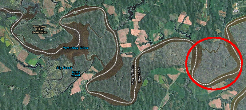
the Sweet Hall Marsh component of the Chesapeake Bay National Estuarine Research Reserve is dowstream from the Pamunkey Indian Reservation on the Pamunkey River
Source: ESRI, ArcGIS Online