Source: Fish and Wildlife Service Chesapeake Bay/Susquehanna River Ecosystem
Maps based on state boundaries rather than physiographic provinces or watersheds often truncate the Chesapeake Bay, ignoring ecological boundaries. The DeLorme Atlas and Gazetteer for Virginia, for example, stops at the Maryland state line. Those arbitrary state lines limit the scope of our maps, and too often limit the scope of our thinking regarding how to "Save the Bay."
Source: Fish and Wildlife Service Chesapeake Bay/Susquehanna River Ecosystem
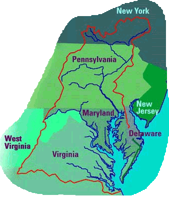
The Susquehanna River starts in New York and Pennsylvania, then crosses into Maryland before emptying into the Chesapeake Bay. If you stop looking at the Virginia/Maryland border, you won't see that the Chesapeake Bay is actually the drowned mouth of the Susquehanna River. Look closely at the white line on this image (below) from a USGS poster, outlining the 64,000 square miles that form the Chesapeake Bay watershed in many more states than just Virginia:
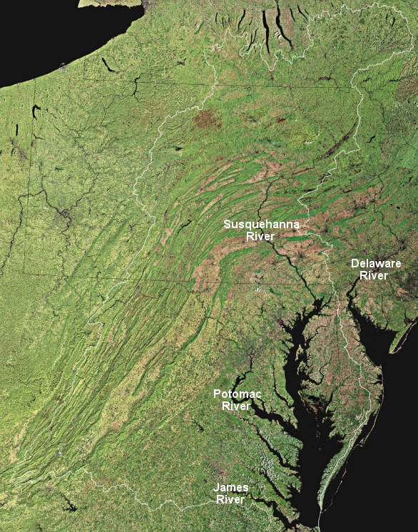
the white line shows the boundaries of the Chesapeake Bay watershed, which includes 64,000 square miles in six states plus the District of Columbia
Source: US Geological Survey
|
Elevation differences on the land and under the water are key parts of living in "Tidewater." Can you see that about half of Delaware, north of the Eastern Shore, is included in the Chesapeake Bay watershed? Did you notice that the watershed boundary splits the Eastern Shore? Much of the land east of Route 13 drains directly into the Atlantic Ocean and - like the eastern half of Delaware - is not included in the Chesapeake Bay watershed.
The underwater equivalent of a topographic map is normally called a bathymetric map. In this topographic/bathymetric map, the bathymetry and the topography are both displayed. The elevation changes in the Bay were exaggerated on the map to highlight the shape of the river channels that form the bay's bottom - but even without exaggeration, you can clearly see the ridge in the middle of the Eastern Shore. The mouth of the Susquehanna River and other rivers on Virginia's eastern edge were drowned over the last 15,000 years. When the level of the Atlantic Ocean rose as glaciers of the Ice Age melted, first the continental shelf was flooded - and then the rising ocean formed the Chesapeake Bay as it moved further into the Susquehanna River valley. (The Chesapeake Bay averages less than 30 feet in depth.) People once lived on what is now the bottom of the Bay - the current outline of the bay stabilized about 3,000 years ago.
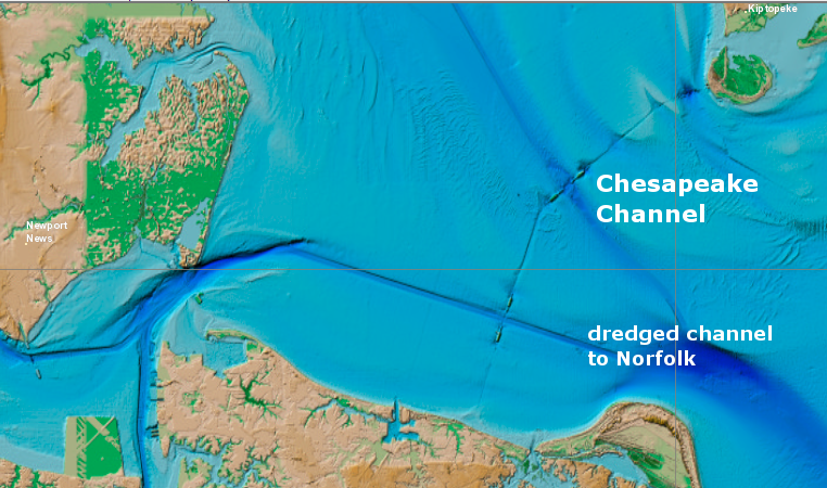
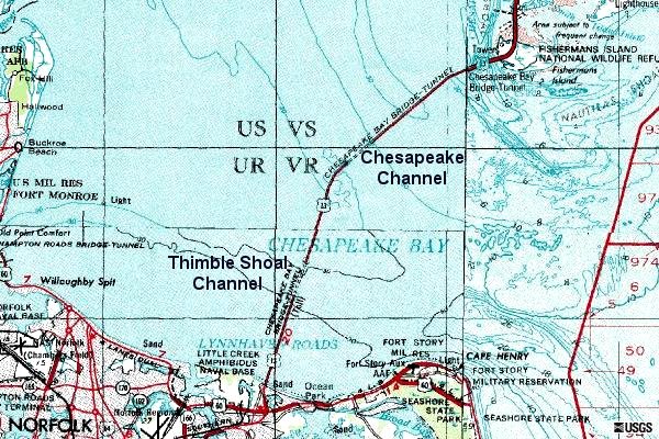
You can tell from the highway map or the Atlas that the Chesapeake Bay Bridge-Tunnel carries Route 13 from Northampton County to the city of Virginia Beach. However, the usual maps don't show you that the separate channels of the James River and the Susquehanna River form separate paths through the mouth of the Chesapeake Bay to the Atlantic Ocean. |
 a ridge defines the bayside/seaside sections of the Eastern Shore Source: Color Landform Atlas of the United States, Chesapeake Bay |
The Chesapeake Bay Bridge-Tunnel has two tunnels - the southern tunnel crosses Thimble Shoal Channel, and the northern tunnel crosses the Chesapeake Channel. Why two tunnels? Before the Chesapeake Bay Bridge-Tunnel was constructed, the Navy was concerned that an enemy would be able to destroy any highway bridge and block the channel between the huge Norfolk Naval Base and the Atlantic Ocean.
The solution was to include a tunnel, so there would always be an open channel to the sea. The engineers included two tunnels, since Mother Nature had already created two channels... one carved by the James River at Thimble Shoal, and the other by the Susquehanna River at Chesapeake Channel.