sand at Cape Henry (City of Virginia Beach) | 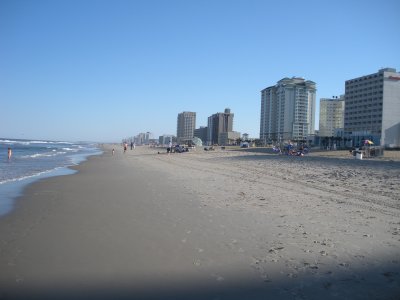 shoreline at Virginia Beach (where many Virginia mountains end up) |
Based on what you learned last week, you know that an individual tiny grain of sand now settling into the Chesapeake Bay or being pushed around by waves at Virginia Beach may be a billion years old. It may have crystallized from molten rock during the Grenville Event, been pushed deep underground in the roots of the ancient Alleghenies when continents collided in the Alleghanian orogeny, exhumed by erosion over the last 200 million years, been scraped loose by a hiker's boot on Old Rag Mountain, and then washed down to the Atlantic Ocean in recent (Quaternary) time. When that sand grain reached the Coastal Plain, it may have been consolidated into a stable rock formation underlying George Washington Birthplace National Monument in Westmoreland County, before breaking free again to become part of an unconsolidated sand dune south of Sandbridge at False Cape State Park.
sand at Cape Henry (City of Virginia Beach) | shoreline at Virginia Beach (where many Virginia mountains end up) |
Humans define the edges of cultural features, such as the southeast edge of Virginia at False Cape State Park. Humans also define the edges of natural features. Humans determine where a river "starts" or "stops," and assign names to places.
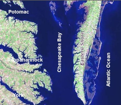
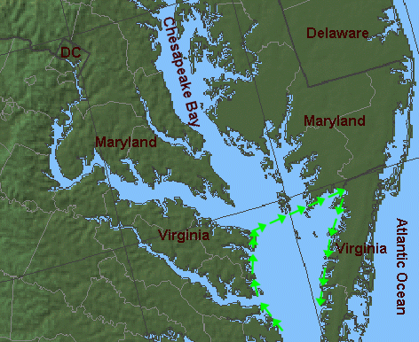
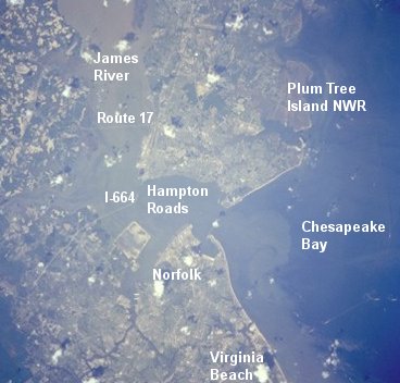
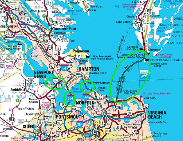
Most people define the Chesapeake Bay as stretching from the mouth of the Susquehanna River (the northern tip of the bay) to the gap between the Eastern Shore and Virginia Beach (the southern tip), plus or minus a few bumps around the edges to the north or south. It gets tricky at Hampton Roads - how much of the James River should you include within the "Chesapeake Bay"? You could define the Chesapeake Bay to extend from the Newport News Shipyard (north end of Route 17 bridge over the James River) all the way east to the Atlantic Ocean. The land on the northern side of the entrance to the Chesapeake Bay (Cape Charles) and the southern side (Cape Henry) define the "mouth" of the Chesapeake Bay, separating it from the Atlantic Ocean.
Both capes, based on the charters of Virginia and the other colonies, are clearly within the boundaries of the Commonwealth of Virginia. Just after the Revolutionary War, Virginia might have imposed a tax at the mouth of the Chesapeake on ships headed to/from Maryland. However, the Compact of 1785 traded away Virginia's "right" to tax shipping entering the bay, in order to resolve ownership and access rights to the Potomac River and upper bay. (Later, the Constitution written in 1788 in Philadelphia would include a Commerce Clause, so the new Federal government rather than individual states would control trade.)
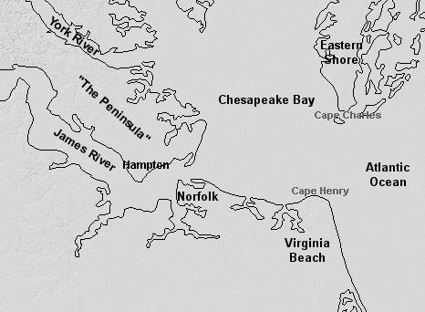
You will use the DeLorme Virginia Atlas & Gazetteer to get familiar with the boundaries of the Chesapeake Bay, in this week's Map Exercise. Start on the southeast corner of the Bay at Cape Henry. Follow the southern boundary of the bay from Old Cape Henry Lighthouse, going westward along the southern edge of the water. Go past the southern terminus of the Chesapeake Bay Bridge-Tunnel, and keep going west past Interstate 64 and the southern terminus of the Hampton Roads Bridge-Tunnel.
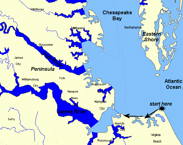
Hampton Roads is the stretch of water separating Norfolk from Hampton, the confluence of the James, Nansemond, and Elizabeth rivers. By one interpretation, Hampton Roads was named because in the early colonial days of the 1600's, that's where ships "rode at anchor" safely after crossing the dangerous Atlantic Ocean. NOTE: The place name "Hampton Roads" refers to both the water area and the urban region, which stretches from Williamsburg to the Atlantic Ocean. (If you think this can be confusing, wait until we talk about "Tidewater.")
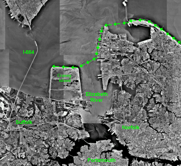
Keep tracing the boundaries of the Chesapeake Bay, using the Atlas and Gazetteer. Go west from the southern terminus of the Hampton Roads Bridge-Tunnel, across the mouth of the Elizabeth River (don't trace the shoreline of the river into downtown Norfolk, to the south...), until you reach Craney Island.
That angular-shaped edge of the waterfront was created artificially by the Corps of Engineers. It's used to store sediments dredged from the shipping channels through Hampton Roads. The Corps maintains specific channels (ditches in the bottom of harbor) that are deep enough for modern ships to sail into the bay - especially aircraft carriers that are based at the Norfolk Naval Station, and built at Newport News.
Still using the DeLorme Virginia Atlas & Gazetteer, follow the northern and western boundaries of Craney Island. Keep going upstream to where Interstate 664 (I-664) crosses the mouth of the James River via the Monitor-Merrimac Memorial Bridge-Tunnel.
Cross the James River, tracing the route of the Monitor-Merrimac Memorial Bridge-Tunnel (I-664) north to the city of Hampton on the Peninsula. The southern edge of the "Peninsula" (the land between the James and York rivers) is the northern portion of the urbanized land area called Hampton Roads. On the Peninsula, you will find the cities of Hampton (the oldest continuously-occupied city in the United States that was first settled by English colonists), Poquoson, the curiously-named Newport News, and Williamsburg.
Before we trace the bay further, look closely at the transportation network in Hampton Roads. The James River and Hampton Roads are major barriers to auto/truck traffic in southeastern Virginia, and Hampton Roads has the worst traffic congestion in the state - outside of Northern Virginia, of course.
Proposals for new bridge-tunnel projects are hotly debated. In 2002, voters in Hampton Roads rejected a proposal to increase the sales tax (from the 4.5% at that time to 5.5%). The extra revenue would have financed a "Third Crossing" of Hampton Roads, connecting Virginia Beach/Norfolk/Portsmouth/Chesapeake/Suffolk to the Peninsula by linking Norfolk, Craney Island, and I-664.
That 2002 proposal failed, but in 2007 the General Assembly used a different approach in House Bill 3202 to finance additional crossings. The state legislature authorized local governments to enact taxes to fund the Hampton Roads Transportation Authority, expecting that regional authority to fund the "Third Crossing." The Virginia courts ruled the mechanism to have an unelected body impose taxes was unconstitutional, so funding for the Third Crossing remains the major challenge before any construction will begin.
The name of "Third Crossing" ignores the Chesapeake Bay Bridge-Tunnel (US 13), between Virginia Beach and Northampton County on the Eastern Shore. The Chesapeake Bay Bridge-Tunnel has tunnels that connect Norfolk/Virginia Beach with the Eastern Shore, but it's located on the east side of the Chesapeake Bay. The entrance to the Bay, where the Chesapeake Bay Bridge-Tunnel connects Northampton County and the City of Virginia Beach, is past the eastern edge of the safe harbor where ships could ride at anchor. Also, the Eastern Shore is not yet considered to be part of the *urbanized* Hampton Roads region.
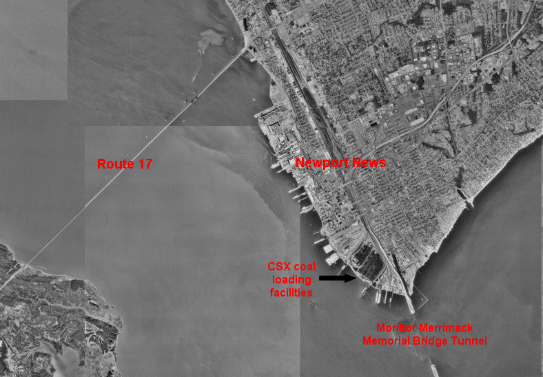
The Route 17 bridge across the James River upstream of the I-664 bridge-tunnel does not count in the local math, only tunnels. The Route 17 bridge is only a bridge, with no tunnel, and it's too far upstream. In some eyes, that bridge is not perceived as crossing the waters of Hampton Roads. The Route 17 bridge crosses just the James River.
That's why only "two" crossings connect the region south of Hampton Roads (Cities of Suffolk, Chesapeake, Norfolk, Virginia Beach...) with the Peninsula north of Hampton Roads. The Hampton Roads Bridge-Tunnel (I-64), and the Monitor-Merrimac Memorial Bridge-Tunnel (I-664) are the current "two" crossings.
Don't be surprised if, after another tunnel is built, transportation specialists and commuters stuck in Hampton Roads traffic begin talking seriously about funding a "Fourth" or even a "Fifth" crossing. However, the regional leaders are divided on transportation priorities, and the Virginia Department of Transportation demonstrated its independence of local priorities in August, 2010. The state agency asked for proposals to expand the Hampton Roads Bridge-Tunnel, catching the Hampton Roads Transportation Planning Organization by surprise. The Norfolk mayor said VDOT's action was "a break of trust."2
Then, in 2011, the Virginia Department of Transportation switched strategy again. Rather than expand the congested Hampton Roads Bridge-Tunnel, VDOT proposed building a new east-west link ("Patriot's Crossing") to divert some of the Hampton Roads Bridge-Tunnel traffic to the Monitor-Merrimac Memorial Bridge-Tunnel (I-664). The Patriot's Crossing bridge-tunnel would also provide truck access to the new port terminal on Craney Island.

If the Hampton Roads politicians remain divided on whether to expand the Hampton Roads Bridge-Tunnel or build a Third Crossing of some other sort, Northern Virginia politicians will be looking for yet more opportunities to direct the limited VDOT funding towards their region. Hampton Roads officials may have thought it was "their turn" after a surge of state/Federal funding replaced the Woodrow Wilson Bridge, expanded the I-95/Beltway interchange at Springfield, and started the Silver Line extension of Metrorail to Dulles... but the competition between Virginia's regions for an outsized share of transportation funding never stops.
OK, back to the map exercise, tracing the outline of the Chesapeake Bay. We will not follow the James River upstream to Richmond.
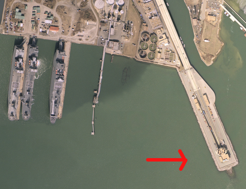
Instead, cross the mouth of the James River on I-664, via the Monitor-Merrimac Memorial Bridge-Tunnel. I-664 connects the city of Suffolk on the south side of the James River to the city of Newport News on the "Peninsula," the land between the James and York rivers. We will turn right at the northern end of the Monitor-Merrimac Memorial Bridge-Tunnel - but take a quick side trip along the James River shoreline to the northwest, up to Newport News. You will see the railroad tracks and coal loading facilities of the CSX railroad, then the piers of Newport News Shipyard (the only place where the United States builds aircraft carriers now), before you reach the US 17 bridge.
OK, enough exploring in Hampton Roads; back to the northern end of the Monitor-Merrimac Memorial Bridge-Tunnel.
Follow the edge of the Chesapeake Bay to the northeast, from Newport News towards Hampton and then (on the next map in the DeLorme Virginia Atlas & Gazetteer) past Old Point Comfort and Fort Monroe. Keep going north along the western edge of the Chesapeake Bay and you'll pass Plum Tree Island National Wildlife Refuge, a collection of wetlands and marshes.
These undeveloped lands and waters were once a bombing range, and Hurricane Isabel in 2003 exposed new bombs that weapons disposal experts had to remove carefully. Designating the area as a wildlife refuge ensures the migrating birds will occupy the site instead of townhouses, and the marshes will continue to supply food and shelter to fish and crabs in the Chesapeake Bay... and reduces the potential for children and their pets to trigger unexploded ordinance that may be revealed after storms each winter.
After Plum Tree Island National Wildlife Refuge, follow the border of the Chesapeake Bay north past the York River, Mobjack Bay, and the Rappahannock River. Go north to the Potomac River... where Virginia stops. The Chesapeake Bay itself goes much further north, but you cross into Maryland as soon as you pass Smith Point and get past the shoreline of the Potomac River. If you're in the middle of the Potomac River, you're in Maryland.
For this "Trace the Bay" exercise, go due east from the mouth of the Potomac River (the "mouth" is where the Potomac River water joins with the Chesapeake Bay). Going east from the mouth of the Potomac River across the Chesapeake Bay, zigging and zagging among the islands along the line defined in the 1877 arbitration by Black and Jenkins until you reach the mouth of the Pocomoke River (where the Calvert-Scarborough Line defined the Maryland-Virginia boundary in 1688). When you intersect land at the western side of the Eastern Shore ("bayside," to the locals), turn south.
Follow the Chesapeake Bay shoreline from Accomack County south to the community of Cape Charles in Northampton County. Keep on going south past Kiptopeke State Park to the southern tip of the Eastern Shore, and you'll be at the northern terminus of the Chesapeake Bay Bridge-Tunnel (US Route 13). If you had spectacular vision, you might look south and see Cape Henry, just across the mouth of the Chesapeake Bay. (Question: where is the "mouth" of the Chesapeake Bay? Answer: where the waters of the bay merge into the Atlantic Ocean, between Cape Charles and Cape Henry.)