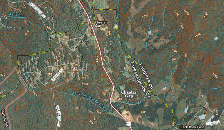
the headwaters of Rappahannock River are near Chester Gap
Source: US Geological Survey (USGS), The National Map
You've been reading the words "watershed" and "divide" and "tributary" - but how would you define them? The concept of a watershed is fundamental to managing water quality and dealing with potential environmental impacts of new roads, housing developments, factories, etc.
When someone talks about sailing downstream to the "mouth" of the Rappahannock River, they're referring to the place where the river empties into Chesapeake Bay. On the north is Lancaster County, and on the south side of the mouth of the Rappahannock is Middlesex County.
When you see references to "headwaters," you want to look upstream all the way to where the river started in the mountains. Follow the line to where those brown topographic lines on the Atlas are located close to each other, indicating a ridge. Where the blue line stops (or starts, depending upon your perspective) is the headwaters of that stream, and the ridge is the watershed divide between that stream and the adjacent one.
Go upstream from the mouth of a river, and you'll go up the tributaries of that river until you reach the watershed divide.
When going upstream, it's a judgment call to determine which stream to follow in order to find the official start of a river. Defining the headwaters or "head springs" of the Potomac River was a key part of the debate over the boundaries of Virginia and Maryland, and the location of the headwaters of the Rappahannock was a key part of determining the extent of the Fairfax Grant. The British officials in London finally ruled that the headwaters of the south branch of the Rappahannock (the Rapidan) was one defining point for the edge of the Fairfax Grant.
After that ruling, the Virginia Assembly used the Rapidan River to define the boundaries of new counties. Culpeper County was separated from Orange County, because residents needed to deal with different officials to purchase land and pay colonial land taxes ("quit rents").
Lord Fairfax was entitled to sell land and collect quit rents north of the Rapidan, while the colonial officials in Williamsburg were entitled to sell and tax land south of that river. (The beginning of the Rapidan River is where Greene, Page, and Madison County join, near Skyline Drive. Can you use the Atlas to follow the north branch, still called the Rappahannock River today, and see which three counties intersect at its headwaters?)
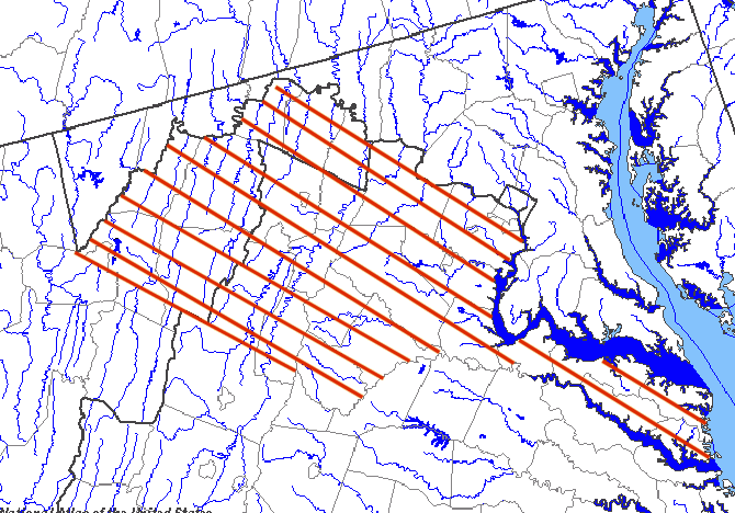
A watershed divide is the ridgeline that separates watersheds. Cumberland Gap is on the Tennessee Valley Divide - rainwater falling on the Virginia side of Cumberland Mountain will drain into the Tennessee River, while rainwater falling on the Kentucky side will drain into the Cumberland River. Look in your atlas, and you will see the Virginia/Kentucky border is also the Tennessee Rive Divide watershed divide until you get near the northwestern edge of Wise County.
Both the Tennessee and Cumberland rivers flow into the Ohio River, so none of the rain that falls in Lee and Wise counties will drain into the Chesapeake Bay. All of their runoff (and whatever pollution may be in that water) goes to the Mississippi River, and ultimately past New Orleans to the Gulf of Mexico.
The Eastern Continental Divide is the ridge that separates the watersheds of streams flowing to the Gulf of Mexico via the Ohio and Mississippi rivers vs. the watersheds of rivers that flow towards the Atlantic Ocean. Between the North Carolina border and Roanoke, the Blue Ridge Parkway marks (roughly) the Eastern Continental Divide in Virginia.
| The Allegheny Front on the western edge of the James River watershed
is the Eastern Continental Divide north of Roanoke, until you reach the
headwaters of the Potomac River. That part of of West Virginia that is in
the Potomac River watershed is actually east of the Eastern Continental
Divide, because the rain will end up draining to the Chesapeake Bay. That
means the western edge of Frederick/Shenandoah/Rockingham counties is NOT
the Eastern Continental Divide, because rain that falls on both sides of
the border will drain into the Potomac River.
The rain that falls on the western side of the Blue Ridge drains into the Holston River (which flows southwesterly into the Tennessee) or the New River (which flows north and to the west through West Virginia, becoming the Kanawha River and joining the Ohio River at Point Pleasant). Between North Carolina and Roanoke, the rain that falls on the east side of the Blue Ridge flows into the Pee Dee river (which reaches the Atlantic Ocean on the coastline of South Carolina) or the Roanoke River (which reaches the ocean near Cape Hatteras, North Carolina). If you go inner tubing on the New River at McCoy Falls near Blacksburg and spill your cooler, your cans of Coke and Budweiser will flow downstream past St. Louis and New Orleans before they end up in the Gulf of Mexico. If you spill your cooler on the Shenandoah River, the cans will float north to Harpers Ferry, then take a sharp right-hand turn before drifting through the Chesapeake Bay to the Atlantic.
|
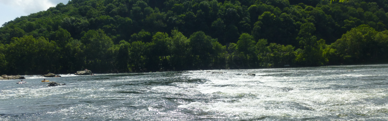 McCoy Falls on the New River was created by differential erosion - the hard quartzite layer that has created Walker Mountain and Sinking Rock Mountain is eroding away slower than the limestone on either side |

