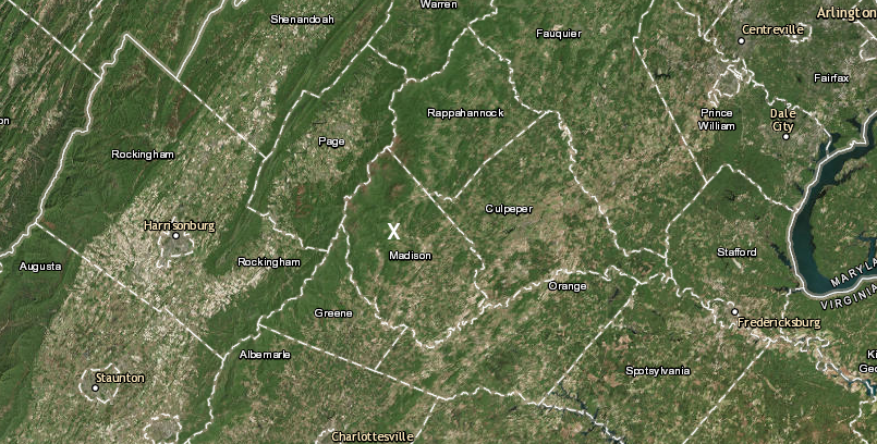
Quaker Run is on the eastern side of the Blue Ridge in Madison County
Source: ESRI, ArcGIS Online
If watersheds are an easy idea for you to grasp - hey, that's great. In some cases, however, the jargon is confusing enough so students lose track of the concepts and get confused by the terminology - hence, this interruption.
Rivers flow downhill from their headwaters, and gravity is the force that causes rivers to flow. The water moves from higher to lower points, eroding a channel as it flows downhill until reaching sea level. All Virginia rivers will flow to the Atlantic Ocean or the Gulf of Mexico.
The headwaters of Virginia rivers are in the mountains, where rainwater flows across the ground and joins together until humans decide there is enough water to justify assigning a name to the water flowing in a defined channel. Rivers flow downstream from their headwaters to their mouth, where they join some other body of water. The place where two streams meet, and one stream loses its identity, is called the confluence.
Quaker Run in Madison County starts when raindrops fall on Chapman Mountain and the eastern edge of the Blue Ridge, then flow downstream to form a channel large enough to be given a name. The colonial settlers called such channels a stream, creek, or run. There was no consistent distinction between those labels, except the largest were called rivers. Humans assigned the names, and humans can be quite creative in their labeling of natural features.
Quaker Run is on the eastern side of the Blue Ridge in Madison County
Source: ESRI, ArcGIS Online
Human judgments to label watercourses were first made about 10,000 years ago when humans first settled what we now call Virginia. We do not know the original names, or even the language of the original names. The names on maps today reflect English colonial decisions. Only a small percentage of Native American place names were retained.
Typically, more water flows in a channel the English called a "river" than a "creek" or "stream." The label "run," such as Bull Run and Four Mile Run, is an artifact of early exploration days. It was applied most often in portions of Virginia that were settled before the French and Indian War in 1755-1763. Not all "runs" are in the Coastal Plain; Blacks Run flows through downtown Harrisonburg in the Shenandoah Valley.
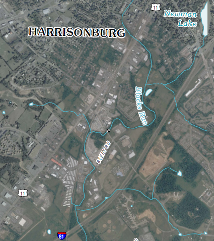
Blacks Run, a tributary of the North Fork of the Shenandoah River, flows underneath I-81 south of Harrisonburg
Source: US Geological Survey (USGS), Bridgewater 7.5x7.5 topographic map (2010)
Place names probably changed many times as the Native American populations shifted, and different tribes occupied the same watershed over the centuries. Most of the Native American names have completely disappeared as European explorers mapped the colony of Virginia in the 1600's and 1700's. A few such names, such as Quantico, Occoquan, Potomac, Rappahannock, Roanoke, and Shenandoah, still remain on modern maps.
Other rivers were assigned names that reflected physical characteristics. The Blackwater River is stained dark with natural tannins that leach out of the trees along the shoreline. Some river names honored English personalities. The James River is named after James I, who was the king of England when the colonists landed at Jamestown.
Quaker Run in Madison County disappears where it meets the Robinson River. The distinction between "Quaker Run" and "Robinson River" was a judgment call made in the 1700's. Early settlers decided to label one channel the Robinson River, and the other channel Quaker Run. The place where the two different channels meet is the called the confluence of the two streams.
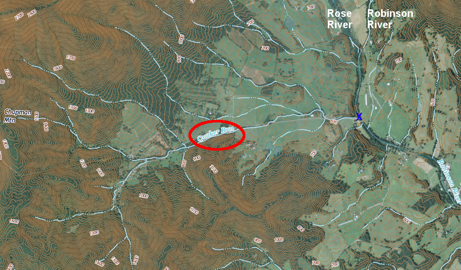
the headwaters of Quaker Run are in the Blue Ridge, its mouth is where it meets the Robinson River, and Quaker Run loses its identify at the confluence (blue X)
Source: US Geological Survey (USGS), ArcGIS Online
The mouth of a stream is always at the opposite end from the headwaters. The headwaters are at the uphill end of a stream at its highest elevation, while the mouth is always at the downhill (or lowest) end of the stream. At the mouth, the water flows into another named stream or lake, or the Chesapeake Bay, or directly into the Atlantic Ocean.
Streams that flow into another another body of water are tributaries of that other stream, lake, bay, or ocean. A tributary loses its distinctive identify at its mouth.
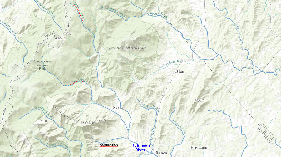
both the Rose River and Quaker Run are tributaries of the Robinson River
Source: ESRI, ArcGIS Online
The land from which rainwater drains into a stream channel is the watershed or drainage basin of the stream. A typical house roof demonstrates the concept of watershed. Rain that falls on the roof drains towards the yard on the left or the right of a house, creating a "left watershed" and a "right watershed."
The ridge at the top of the roof is a watershed divide separating the "left watershed" from the "right watershed." The gutter running vertically down the side of a house could be considered a stream, with its headwaters on the roof and its mouth where the pipe discharges the rainwater onto the ground.
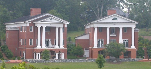
roofs of fraternities at Washington and Lee University with watershed "divides" in the center
Some roofs do not have a ridge at the top, of course.
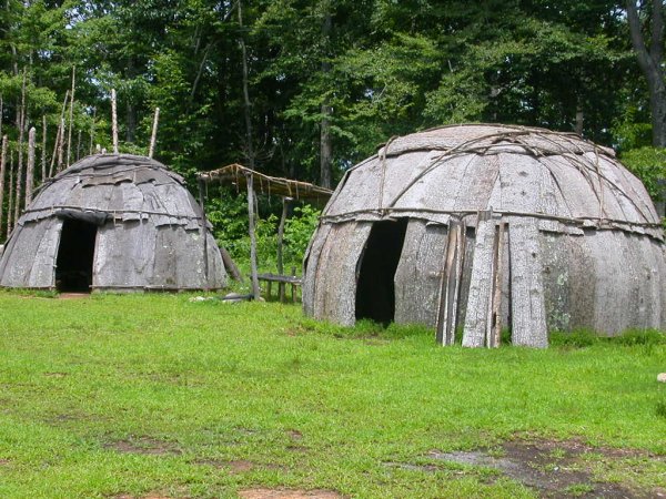
roofs of Totero shelters at former Explore Park near Roanoke, reflecting construction patterns of Native Americans when John Lederer crossed the Blue Ridge in 1671
Two streams can flow together and both lose their identity at their confluence. The Jackson River and the Cowpasture River join to form the James River just downstream from Iron Gate, near Clifton Forge in Alleghany County.
By definition, the mouth of the Jackson River and the mouth of the Cowpasture River are the downstream ends of those rivers.
By definition, the starting point of the James River is at the confluence where the Jackson and Cowpasture rivers meet.
By definition, the Jackson and Cowpasture rivers are tributaries of the James River, and the James River is a tributary of the Chesapeake Bay.
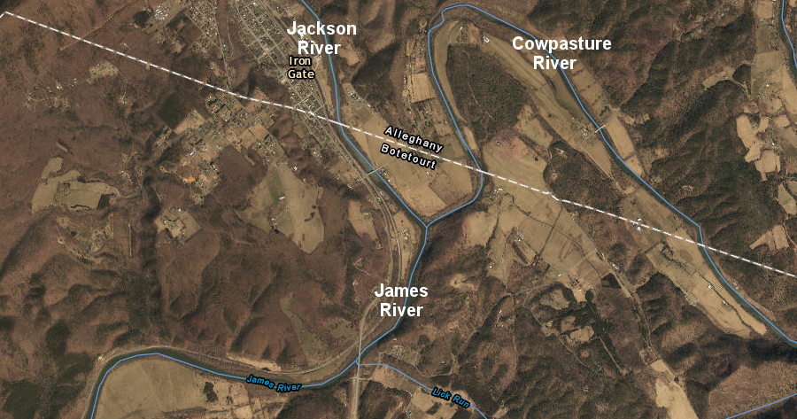
the "start" of the James River, where the Jackson River and Cowpasture River meet
Source: ESRI, ArcGIS Online
The Bullpasture River, Cowpasture River, Calfpasture River, and Little Calfpasture Rivers are all tributaries of the James River. The Bullpasture River flows into the Cowpasture River, so it is a tributary of the Cowpasture River.
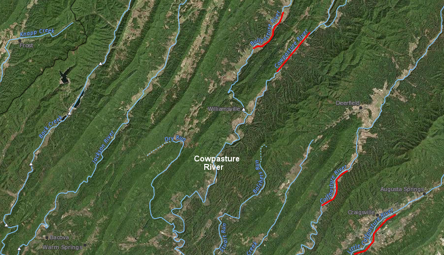
the Bullpasture, Cowpasture, Calfpasture, and Little Calfpasture rivers are all tributaries of the James River, and the Bullpasture River is a tributary of the Cowpasture River
Source: ESRI, ArcGIS Online
The Calfpasture and Little Calfpasture rivers are not tributaries of the Cowpasture River. The raindrops that fall in the watersheds of the Calfpasture and Little Calfpasture rivers never flow in the channel of the Cowpasture River. They do join the raindrops that fell in the Cowpasture River watershed and flow together down the James River to the Chesapeake Bay, but the water in the Calfpasture and Little Calfpasture rivers does not flow into the channel of the Cowpasture River.
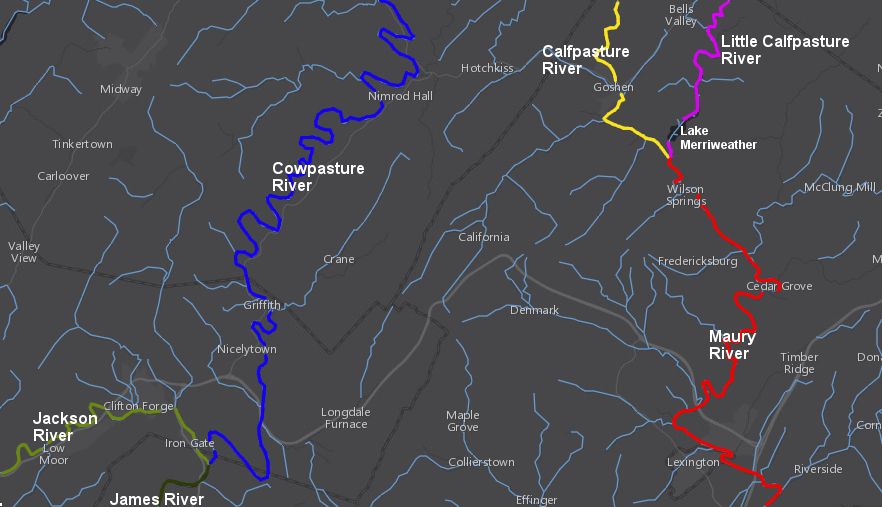
The Calfpasture and Little Calfpasture rivers flow together just east of Goshen in Rockbridge County. The Boy Scouts purchase 4,000 acres near the mouth of the Little Calfpasture River and built a dam in 1966, creating Lake Merriweather for recreational use.
The stream exiting Lake Merriweather is still called the Little Calfpasture River, but that streams ends less than a mile later at the confluence of the Calfpasture and Little Calfpasture rivers. That confluence is the starting point of the Maury River, so the Calfpasture and Little Calfpasture rivers are tributaries of the Maury River.

the confluence of the Calfpasture and Little Calfpasture rivers is the starting point of the Maury River
Source: ESRI, ArcGIS Online
The Maury river flows through Lexington, home of Washington and Lee University and the Virginia Military Institute (VMI), before flowing into the James River. By defintion, the Maury River is a tributary of the James River.
The Maury River joins the James River at Glasgow, downstream from Iron Gate and the confluence of the Jackson and Cowpasture rivers. As a result, the water in the Maury River does not flow into the Cowpasture River.
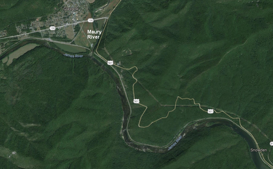
the confluence of the Maury and James rivers is at Glasgow, just upstream of where the James River cuts through the Blue Ridge at Balcony Falls
Source: Google Maps
The Maury, Calfpasture, and Little Calfpasture rivers are all tributaries of the James River. The water that flows down the Maury, Calfpasture, and Little Calfpasture rivers also flows down the James River.
The Cowpasture River is a tributary of the James River. Water flowing down the Cowpasture River also ends up flowing down the James River.
However, the raindrops that start off in the Calfpasture and Little Calfpasture rivers, then flow into the Maury River and down the James River to the Chesapeake Bay, never flow in the Cowpasture River channel. By definition, the Maury, Calfpasture, and Little Calfpasture rivers are not tributaries of the Cowpasture River.
the Calfpasture and Little Calfpasture rivers are NOT tributaries of the Cowpasture River or the Jackson River
Source: ESRI, ArcGIS Online
The South Fork of the Shenandoah River starts at Port Republic and ends at Front Royal. Upstream from Port Republic, the water had flowed down various channels known as North River, Middle River, South River, Christians Creek, Lewis Creek, etc.
Those streams/rivers/creeks are tributaries of the South Fork of the Shenandoah River. Starting at Port Republic, the same water flows in a channel that humans have labeled the South Fork of the Shenandoah River. Humans have chosen to define the mouth of the South Fork of the Shenandoah River to be at Front Royal.
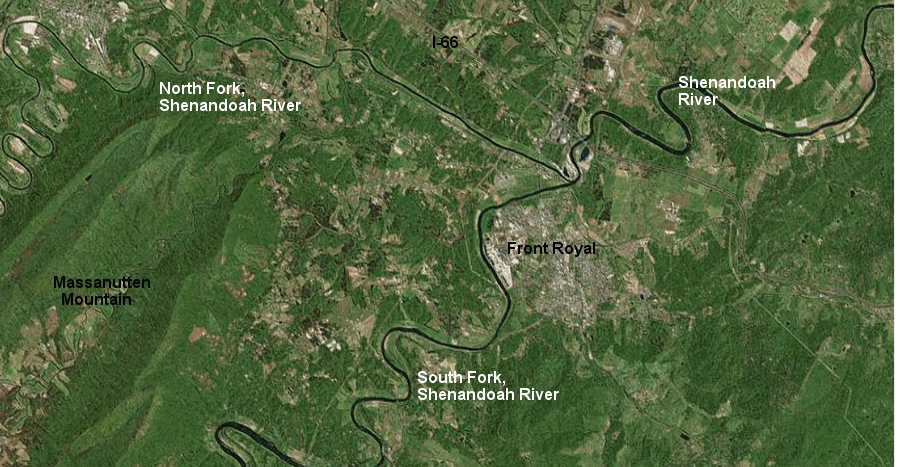
the confluence of the North Fork and the South Fork of the Shenandoah River at Front Royal is the beginning of the main stem of the Shenandoah River (which ends at its confluence with the Potomac River at Harpers Ferry)
Source: Microsoft Research Maps
The end of the South Fork of the Shenandoah River is where it joins with the North Fork of the Shenandoah River, at Front Royal. Downstream from Front Royal, there is no "South Fork of the Shenandoah River." Instead, between Front Royal and Harpers Ferry, the river is called just the "Shenandoah River."
raindrops that fall in the watershed of the South Fork of the Shenandoah River will end up flowing down the main stem of the Shenandoah River between Front Royal and Harpers Ferry
Source: US Geological Survey (USGS), Streamer
Streams run into each other and form larger streams. Only a few streams along the Atlantic Ocean coastline never merge with some other stream.
It does not matter to the water molecules whether the name of the channels in which they flow are changed as the water flows downhill. Names of channels may change, but those different names do not change the influence of gravity.
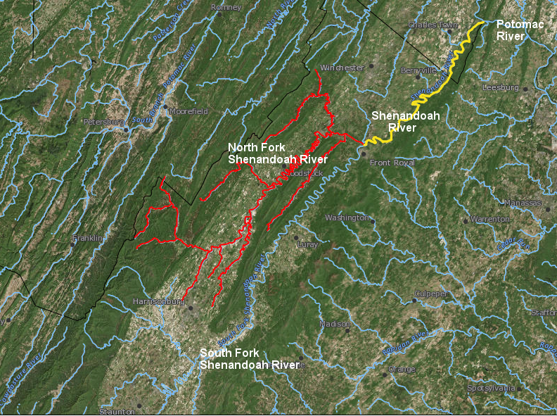
raindrops that fall in the watershed of the North Fork of the Shenandoah River will end up flowing down the main stem of the Shenandoah River between Front Royal and Harpers Ferry
Source: US Geological Survey (USGS), Streamer