Birthing a Mouse: What Lessons Can Be Learned From the Failure of Fairfax Planning at Vienna Metro Station?
The story of development at Vienna Metro Station in Fairfax County reveals the challenges with integrating land use and transportation planning, and the difficulty of re-shaping a place with Transit Oriented Development (TOD) once it is no longer a greenfield. Four major "lessons learned" can be applied when planning transit extensions to stimulate land use changes.
Lesson #1: Proactive Leadership Is Required to Integrate Land Use and Transportation Plans
In the 1950's, visionary regional plans for the National Capital Region:1
- were developed on the premise of a strong, unified governmental role, dominated by Federally chartered regional institutions with sufficient authority to build the facilities they planned and to impose the controls and limitations on development to make the plans work.
China has demonstrated the effectiveness of the top-down planning approach since 1990, transforming rural areas to create Pudong New Area outside Shanghai and other Special Economic Zones. In Northern Virginia, however, that approach will fail.
As William Whyte has noted:2
- The marginal effect that planning can have on growth can be very important. But it is limited. Most of the factors involved are what the planners call exogenous – that is, there’s damn little the planners can do about it.
Land use and transportation leadership was particularly weak and inconsistent in Fairfax, at the time the Metrorail system was planned. From the 1950’s into the 1980’s, political control of the county shifted from politicians focused on growth controls to those supporting new development.
In the mid-1960’s, when key decisions were made about the Orange Line, implementation of visionary plans was undercut by parochialism and corruption. Rezonings were decided on a site-specific basis, reflecting the business objectives of landowners/developers rather than the "wedges and corridors" or smart growth concepts of planners. In 1966, two supervisors and other officials were indicted for taking bribes related to land use cases.3
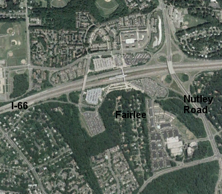
in 2003, four-story townhomes had been built north of the Vienna station and the Fairlee subdivision was still intact south of the Orange Line
Source: Google Earth
|
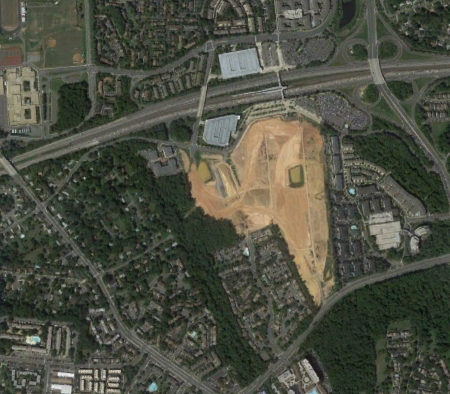
in 2010, Pulte had removed the 69 single family homes in the Fairlee subdivision and begun construction of the MetroWest development
Source: Google Earth
|
Regional plans were ignored, as was Fairfax's own Western County Development Policy to constrain sprawl.4
-
[T]hough the Board of Supervisors gave lip service to the philosophy of the Year 2000 plan, there were no real attempts—other than the notable exception of the new town of Reston—to implement the development of the ‘satellite’ cities that would provide shopping and employment within walking distance of many residents.
County officials have sticks and carrots to shape development. The carrots are publicly-funded infrastructure – sewers, schools, roads, libraries, etc. – to incentivize development in certain locations. The sticks are zoning controls, permitting high density development in preferred areas while blocking development in other locations, plus refusal to build infrastructure where growth is not desired. The Planning and Land Use System (PLUS) developed by Fairfax in the 1970’s presumed government officials could determine where and when growth would – and would not – occur.5
However, court decisions, shifting priorities of the voters, and reactive elected officials limited the power of Fairfax officials to steer growth to a few high density areas. Instead of “working the plan” so growth was concentrated along roads and rails separated by wedges of low-density, Fairfax’s growth in the 1960’s and 1970’s was shaped by fragmented initiatives of competing developers and by sewer capacity.6
In 1982, the courts finally empowered county officials and approved the downzoning of 41,000 acres near the Occoquan Reservoir. By then, however, the die was cast; there would be no other low-density conservation zones. The remaining question became "where would high-density zones be developed?"7
Lesson #2: New Transit Stations Do Not Automatically Spur Economic Development and Neighborhood Revitalization
The cost-effectiveness of Metro was not a major factor in the Fairfax budget process during the 1960’s, because Federal subsidies financed most of the initial costs. In 1962, Fairfax approved a new mall at Tysons Corner - but failed to align Metro to serve it, when the Adopted Regional System was finalized in 1967 or during another alternatives analysis in 1978.8
In the 1960’s, Fairfax supervisors used the Northern Virginia Transportation Commission (NVTC) to reach consensus on Metro routes. Fairfax supported a route ending in Vienna rather than Tysons, in part because of the lower construction cost but also to obtain the vote of the NVTC commissioner from the independent city of Fairfax.9
- NVTC's detailed report outlining eight potential rail corridors in Northern Virginia did not even mention Tyson's Corner. Instead, the commission staff prepared a detailed report on how, rather than whether, to bring rail to Fairfax City... At the point when alignments were most plastic, neither NVTC nor WMATA planners seriously considered bringing rail to the place Fairfax planners designated as the future crossroads of the county.
The K route (now the Orange Line) was extended all the way to Vienna after the Washington Metropolitan Area Authority (WMATA) replaced the National Capital Transportation Agency in 1967.9
- Whereas the NCTA had been responsible primarily to Congress, WMATA had to please its eight constituent jurisdictions as well. Rather than sticking to thrifty plans... the new Authority was tempted to think big in an effort to please as many people in as many places as it could.
The Orange Line could have gone further to what is now Fair Oaks, where there was even more undeveloped land – but the extra costs would not have generated extra votes on NVTC, and Metro was not viewed as an economic development tool. If the line was extended any further than Vienna, customers would have to ride for over ˝ hour to get to jobs in DC.
WMATA planners assumed the purpose of the rail system was just to move commuters to the city center. Fairfax supervisors passively accepted WMATA’s proposal to route the Orange Line through the median strip of I-66. A route that minimized land acquisition costs would be more likely to be approved by local voters in 1968, since 40% of the funding formula for each locality was based on construction costs in that jurisdiction.11
More fundamentally, the Fairfax supervisors lacked recognition that routing the Orange Line could stimulate economic development, and officials were also diverted by the bribery scandal. "[A]s a body, it was scarcely paying attention" to the Orange Line.12
Supervisors treated Metro one-dimensionally, viewing it as a transportation tool to transport workers to the job centers in DC (like the Bay Area Rapid Transit System in San Francisco) rather than as an investment to stimulate economic activity in Fairfax.
Consultants made crystal clear the requirement for local officials to revise land use plans to increase density at transit nodes, in order for Metro to trigger economic development:13
- - Strong Metro orientation within a station site vicinity will most likely not occur automatically in all instances, and may have to be created. The fundamental question posed by the location of Metro stations within Fairfax County therefore, is whether Metro can (or should) be viewed primarily as a vehicle for change – thus maximizing its potential to generate development activity within its vicinity – or as a vehicle for either retaining the basic character of an area or strengthening the already-existing market demand, while serving primarily as a transportation node.
- - ...if Metro-orientation is the policy objective, the appropriate environment will have to be created.
- Those consultants posed three alternatives:
- - As a transportation node, is Metro (1) primarily a feeder station for automobiles and buses – in which the major concerns would be adequate parking and traffic congestion on local streets – or, 2) primarily a self-contained system where the physical pattern of development will determine Metro ridership levels at the site, or 3) a combined environment of self-contained activities providing Metro ridership, along with automobiles and feeder buses bringing additional passengers to and from the stations and their vicinities?
- - The advantages to policymakers in considering Alternative One is that it would most likely generate the least traffic impact on the larger portion of the complex area beyond the immediate station site vicinity and the least community opposition, while reinforcing existing development trends. However, according to our analysis, it would be the most fiscally disadvantageous, and would not maximize the potential for Metro as a catalytic tool in the development process...
- - Should a strong public commitment to achieving Metro orientation not be forthcoming, then, given the logical tendency of suburban station sites to reinforce existing patterns… we would have to recommend the minimum alternative – Alternative One – for each station site.
Other studies clarified the specific opportunities at the Vienna site, where 270 acres was vacant.14
- The large amount of vacant land allows a concentrated development which could become a development node in Northern Virginia in the future. A concentrated development at the Vienna Station could encourage tenants and residents who would consider alternative locations in Fairfax County to be concentrated more at the Vienna Station because of the amenities made possible through a larger development. Thus, a planned, high intensity development at Vienna could concentrate some development which would otherwise be built at scattered locations in Fairfax County.
Potential development was specified by category:
| Land Use | Units/S.F. |
|---|
| Residential | 2,750-5,200 dwelling units |
| Office | 100,000-500,000 square feet |
| Retail | 30,000-100,000 square feet |
| Hotel/Motel | 100-300 rooms |
However, when DeLuca Enterprises proposed eight high rises just north of the station in 1973:15
- the Board of Supervisors crumpled when faced with opposition from existing residents in the area and the nearby Town of Vienna.
Nearby residents and Vienna town officials objected to new density, fearing traffic congestion. Only townhomes were developed at Virginia Center.
Vienna has sought to be a "satellite village" rather than to grow into an urban downtown. While the town could not conserve a greenbelt of parkland on its borders, it has opposed density increases nearby.16
- During the last quarter century, Vienna has established and followed policies designed to preserve and enhance its small town character as a residential community of predominantly single-family housing, while supporting business development that ensures adequate retail and professional services for the community.
The Vienna Metro Station is a missed opportunity to spur Transit Oriented Development in Fairfax County.17
- [R]ather than imagining rail transit as a tool to shape future land use, the Fairfax officials treated it only as a means to serve existing residential concentrations.
By default, supervisors implemented the Alternative One identified in 1974. For example, when the county bought land north of the station in 1972, it used all 84 acres to create Nottoway Park.18
Lesson #3: Redeveloping in a Residential Area Creates a Community Backlash
Years later, Fairfax reversed its strategy. In 2004, it authorized high-density development on 60 acres south of the Vienna Metro station, after Pulte Homes and Clark Capital Realty acquired 69 homes and bulldozed the Fairlee subdivision.
The Providence District Planning Commissioner made clear in his 2004 motion for replanning that the county lacked the option of putting new density in a no-conflict zone:19
- During the late 1970s and 1980s Fairfax County land use policy focused on maximizing commercial development to improve the tax base, but without a commensurate increase in plans for residential development – thereby guaranteeing Level of Service F for many of our major roads… Fairfax County is now mostly built out. The rail transit stops we presently have are in established neighborhoods. The area around the former Fairlee subdivision is such a neighborhood. For us, transit oriented development is transit oriented redevelopment. The nodal points of density and intensity must be inserted into a built environment, not created in green fields.
The 2006 rezoning proffer from Pulte Homes to create MetroWest defined a Core Area of 23 acres, with a floor area ratio (FAR) of 2.25 and a maximum of 2.8 million of Gross Floor Area (excluding cellars). In contrast to Virginia Center in 1973, one building was authorized to reach 150 feet in height. Five others were capped at 120-135 feet.20
MetroWest was planned primarily as a housing project, with:21
- up to 2,248 housing units, up to 300,000 square feet of office space and up to 190,000 square feet of retail space focused on resident services.
Today, Fairfax is applying "lessons learned" by creating mixed use communities (rather than just residential nodes) on the Silver Line in Tysons and Reston. In July 2009, the county allowed Pulte to switch 700,000 square feet of residential to office use at MetroWest, improving the jobs/housing balance.22
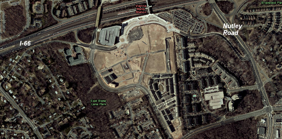
the 69 single family residences in the Fairlee subdivision were purchased and bulldozed by Pulte, which then built the higher-density MetroWest development south of the Vienna station on the Orange Line
Source: ESRI,
ArcGIS Online
Lesson #4: When the Public Feels Planning Is Limited to Landowners/Developers and County Officials, There Are Political Consequences
In December 2004, after the BOCS approved the Comp Plan amendment to authorize rezoning Fairlee and create Metrowest, one civic activist stated:23
- I don't think the average citizen has a clue about what's happening. People moved to Fairfax County with the idea that it was going to be suburban.
- Another claimed:
- They're trying to urbanize the county... I don't think urbanization was a part of anyone's platform in the election.
- The Washington Post noted:
- the transformation of the region's largest suburb promises to roil homeowner politics.
Prior to the Board of County Supervisors approval of the MetroWest rezoning in March, 2006, the opponents felt excluded from discussions. As far back as 1987, civic activists led by Gerry Connolly stated:24
- the entire planning and zoning processes need to be transformed so that they become as user-friendly to average citizens as they have been to commercial and residential developers.
Still, when the supervisors created a TOD Task Force in December 2005 to help clarify what was TOD vs. transit-adjacent development, the task force failed to hold a public meeting until after the vote.25
WMATA contributed to the frustration, claiming it was exempt from Freedom of Information Act requests throughout the decision process to sell (rather than lease) a 3.75 acre parcel to the MetroWest developers.26
US Representative Tom Davis even threatened to use Federal legislation to block the sale, claiming there were problems with the process. In addition, his wife was the state senator representing the Vienna district.27
Opponents of plans for more-dense development near the Vienna Metro station coalesced into the Fairfax Citizens for Responsible Growth. That group proposed a 12-point "Citizens' Agenda For Responsible Development," to counter the official plans presented by the county Planning Department.28
After failing to shape the future through the planning process, one activist took the next step and ran for Providence District Supervisor in 2007. Charlie Hall collected 45% of the vote in a close primary race against the incumbent, Linda Smyth. A key part of his campaign was the claim the supervisors were too complacent in accepting plans for development, and not engaging local residents who would be affected until the process was too far along to be revised:29
- There was this sense we were crashing a private party.
Since then, Fairfax has implemented many recommendations from the Land Use Information Accessibility Advisory Group, which in 2007 made 17 specific recommendations to expand public access to land use information. The county’s website allows quick retrieval of site-specific rezoning data.30
Summary
Development around the Vienna Metro Station was a missed opportunity. While Fairfax supervisors never planned to urbanize all 399 square miles of the county, back in the 1960’s they could have chosen to match Arlington County’s strategy to use the Orange Line to create an equivalent to the Rosslyn-Ballston corridor and concentrate new jobs/housing in Transit Oriented Developments.
Now, 40 years later, county officials are navigating the political challenges of converting already-developed areas near existing Metro stations (and new ones on the Silver Line) into higher density, TOD communities. Limiting redevelopment to commercially-zoned areas in Merrifield and on the Silver Line has muted opposition to change.
In Vienna, there is one remaining old neighborhood just west of MetroWest that could go through the same redevelopment as Fairlee. However, existing residential uses are “locked in” on the remainder of the land within ˝ mile of the station.
Back in 1976, Alternative Three proposed that:31
- the station sites can achieve cohesion as self-contained subcenters of high density residential and employment activity and can maximize Metro ridership at the site, based on a strong public policy to achieve such objectives.
The Vienna Metro station was one place where planning could have done more than "damn little." Now, any such subcenter at Vienna now will be marginal, limiting the cost-effectiveness of the investment in the Orange Line.
References
1. Jonathan Lewis Gifford, Flexible Urban Transportation, Emerald Group Publishing, p.57, http://books.google.com/books?id=yDxdkF-e-ZMC (last checked June 20, 2016)
2. William H. Whyte, The Last Landscape, Doubleday and Company, 1968, p.147
3. A Look Back:1938-2008, 70th Anniversary Issue, Fairfax County Planning Commission, p.6, http://www.fairfaxcounty.gov/planning/historicalbooklet.pdf (last checked June 20, 2016)
4. Lucille Harrigan and Alexander von Hoffman, "Happy to Grow: Development and Planning in Fairfax County, Virginia," Working Paper W04-2, Joint Center for Housing Studies, Harvard University, p. 12
5. Grace Dawson, No Little Plans, Fairfax County’s PLUS Program for Managing Growth, The Urban Institute, 1977 (last checked June 20, 2016)
6. “Northern Virginia Metro Station Impact Study – Phase III A: Market Analysis, Report No. I – Metropolitan and Regional Socio-Economic Analysis,” Northern Virginia Planning District Commission, Falls Church, VA November 1973, p. 11 Implementation of a grand design to use the police power of zoning to limit development outside of satellite cities is unrealistic in Northern Virginia, but Fairfax officials have been able to implement a significant part of their environmental vision. Through incremental proffers in the rezoning process, the county created an extraordinary network of stream corridors and trails. Through voter approval of bonds, Fairfax acquired 10% of the county for parkland. Small steps, following consistent policy over 30 years, did generate major results. (last checked June 20, 2016)
7. "Occoquan Downzoning Successful In Protecting Water Quality," Fairfax County website, http://www.fairfaxcounty.gov/news/2003/03022.htm (last checked June 20, 2016)
8. Zachary Schrag, The Great Society Subway: A History of the Washington Metro, John Hopkins University Press, 2006, pp.189-190
9. Zachary Schrag, The Great Society Subway: A History of the Washington Metro, John Hopkins University Press, 2006, pp.235-236
10. Zachary Schrag, The Great Society Subway: A History of the Washington Metro, John Hopkins University Press, 2006, p.104
11. Zachary Schrag, The Great Society Subway: A History of the Washington Metro, John Hopkins University Press, 2006, p.114
12. Zachary Schrag, The Great Society Subway: A History of the Washington Metro, John Hopkins University Press, 2006, pp.234-235
13. "A Study of Metro Station Impact at Springfield and Huntington Corridor Stations," prepared for the Fairfax County Office of Comprehensive Planning by Real Estate Research Corporation, January 1976, pp.1-5
14. "Northern Virginia Metro Station Impact Study – Phase III A: Market Analysis, Report No. IV – Metro Station Development Issues and Strategies," Northern Virginia Planning District Commission, Falls Church, VA June 1974 p.38-41
15. Zachary Schrag, The Great Society Subway: A History of the Washington Metro, John Hopkins University Press, 2006, p.237
16. "2010 Comprehensive Plan," Town of Vienna, Virginia, p. 24, http://www.viennava.gov/DocumentView.aspx?DID=182 (last checked June 20, 2016)
17. Zachary Schrag, The Great Society Subway: A History of the Washington Metro, John Hopkins University Press, 2006, p.234
18. "Nottoway Park Master Plan Revision," Fairfax County Park Authority, December 8, 2004, http://www.fairfaxcounty.gov/parks/gmp/nottowayMP120804.pdf (last checked June 20, 2016)
19. “Motion: OTPA S02-II-V2, October 13, 2004 – Planning Commissioner Ken Lawrence,” Fairfax County website,
http://www.fairfaxcounty.gov/providence/PDFFiles/OTPAS02IIV2_PC_Law.pdf
(last checked June 20, 2016)
20. Metro West Proffers, Pulte Home Corporation, RZ 2003-PR-022, March 21, 2006, pp.5-9, http://ldsnet.fairfaxcounty.gov/ldsnet/ldsdwf/4326292.PDF (last checked June 20, 2016)
21. "What's New: Fairfax Board Approves Metrowest, Construction to Begin in 2007," MetroWest website, http://metrowestva.com/3-21-06_proffers_BOS.pdf (no longer available online, last checked June 20, 2016)
22. Staff Report, 2008-2009 North County Area Plans Review, APR Item: 08-II-4V, http://www.fairfaxcounty.gov/dpz/apr/2008northcounty/finalstaffreports/4v.pdf (last checked June 20, 2016)
23. Peter Whoriskey, "'Smart Growth' Gains Traction in Fairfax, Some Fear Plan for High-Density Areas Will Uproot County's Suburban Qualities," Washington Post, December 12, 2004, p.C8, http://www.washingtonpost.com/wp-dyn/articles/A58118-2004Dec11.html (last checked June 20, 2016)
24. "Report of the Citizens Committee for the Review of Land Use and Transportation Planning for Fairfax County," July 20, 1987
25. Walter Alcorn, "Thoughts on Linda Smith and Gerry Connolly," Raising Kaine website, June 6, 2007, http://www.raisingkaine.com/8863.htm (last checked June 20, 2016)
26. "Citizen Groups Petition Congress: Subject Washington Metropolitan Area transit Authority to FOIA," Providence District Council Newsletter, December 2005, http://www.dlvhoa.org/newsletters/pdc_dec_05.pdf (last checked June 20, 2016)
27. "MetroWest Point Man in Fight of His Life; Developer Surprised to Be Locking Horns With Rep. Davis Over Sale of Fairfax Parcel," Washington Post, September 12, 2005, p.B3
28. "Roads, Rail, Schools, Parks, Ball Fields, Trails - All Are Reaching the Breaking Point. What Can Be Done?," Citizens' Agenda For Responsible Development, captured by Internet Archive Wayback Machine on November 3, 2006, http://web.archive.org/web/20061103221746/http://www.fairfaxcitizensagenda.org/ (last checked June 20, 2016)
29. "Hall Vs. Smyth: Community activist runs for Board of Supervisors," Vienna Connection, March 28, 2007, http://www.connectionnewspapers.com/news/2007/mar/27/hall-vs-smyth/ (last checked June 20, 2016)
30. "Land Use Information Accessibility Recommendations of the 2006 Advisory Group to the Fairfax County Board of Supervisors," presentation to the Board of Supervisors, January 2007, http://www.fairfaxcounty.gov/landusecomm/WalterFinalBOSLandUseAccessibilityPresentationToBOSJan2007.pdf (last checked June 20, 2016)
31. "A Study of Metro Station Impact at Springfield and Huntington Corridor Stations," prepared for the Fairfax County Office of Comprehensive Planning, by Real Estate Research Corporation, January 1976, p. 5
The Disconnect Between Transportation and Land Use Planning
Land Use Planning in Virginia
Virginia Places