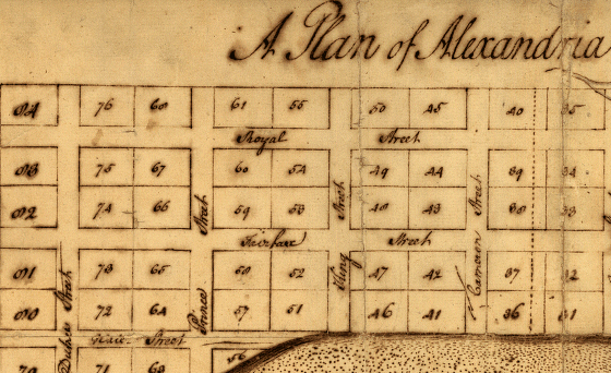
A plan of Alexandria, now Belhaven (George Washington, 1749)
Source: Library of Congress
What good is it to buy property, if you don't know the boundaries of what you bought? You might as well buy a quitclaim deed to the Brooklyn Bridge.
Acquisition of property in Northern Virginia during the colonial era required:
1) payment for the land (through "headrights," issued in exchange for importing people to the labor-starved colony) or treasury rights (sold by the colony), or sales from Lord Fairfax's agents
2) a survey of the land, to document boundaries
More than one person might obtain some sort of official claim to valuable bottomland along a river, for example. The first person to file the survey documenting the territory being purchased from the colony (or Lord Fairfax) would get priority claim on that property. Out in the Shenandoah Valley, Lord Fairfax and Josh Hite engaged in a lawsuit over property rights that lasted 22 years,
Surveying technology was relatively simple in the colonial era. The challenge of pulling a Gunter's chain (sixty-six feet long, with one hundred metal links) through the brush and across rivers, and measuring angles with primitive optics, resulted in a few errors. Northern Virginia was transferred into private hands from government/Lord Fairfax ownership through meets and bounds surveys. Surveyors started at one point, then followed a stright line or an obvious feature such as a creek, until ulimately enclosing some property and returning to the starting point. Towns would be surveyed in rectangular lots, however.
People who try to retrace historic surveys struggle with the colonial surveyor's habit of starting at a "point of beginning" that was selected for short-term convenience, such as a big white oak tree. Today... we have little opportunity to find those trees. The difficulty in registering the points on the historical maps makes it difficult to use geographic information systems to overlay historical plats on modern maps.
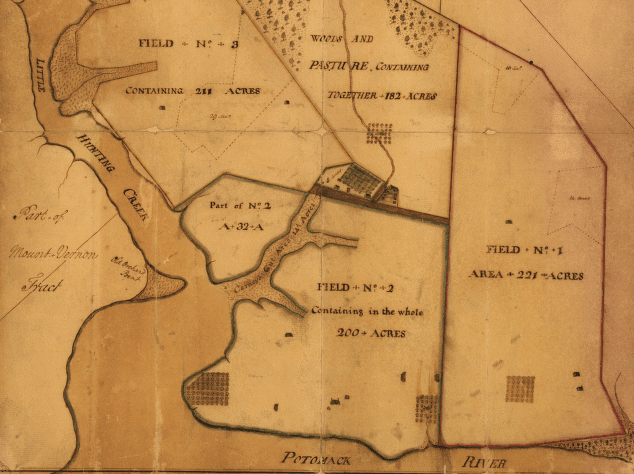
The need to define boundaries has always been important. George Washington surveyed Mount Vernon because he needed to know the acreage in different fields, in order to manage the crops, livestock, and of course the slave labor force:
Read: