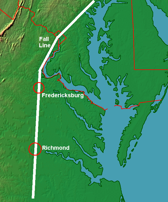
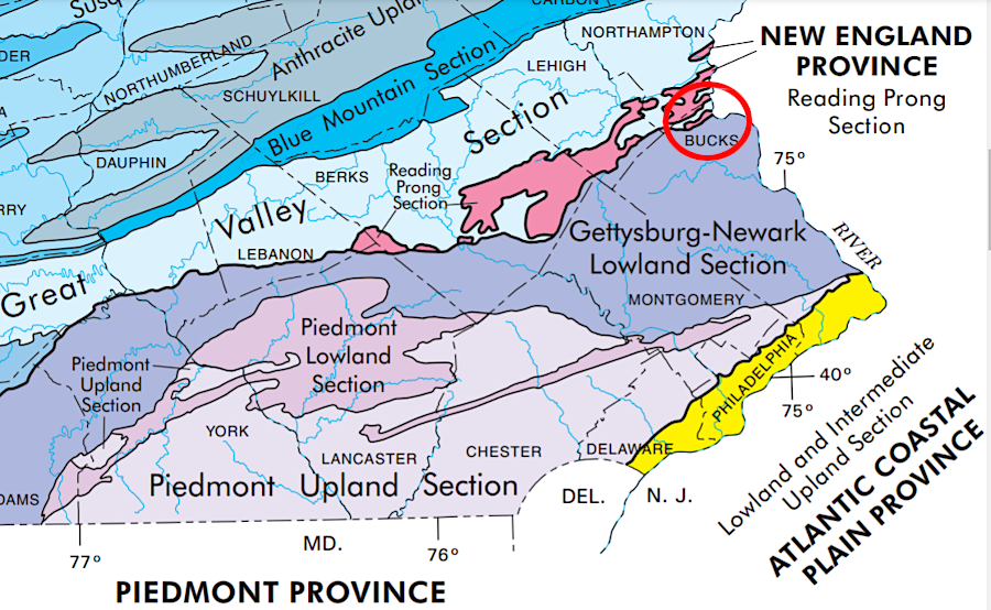
the "Fall Line" is a zone that ranges from 2-11 miles wide
the "Fall Line" is a zone that ranges from 2-11 miles wide
When the English colonists were first exploring Virginia, they quickly explored up the rivers as far as their ships could float. In 1607, Christopher Newport sailed up the James River to the location of what is now Richmond, before returning to England and reporting on his success at delivering 104 colonists to a new settlement called Jamestown.
Newport discovered rapids that blocked further travel. The river which the colonists named after James I dropped over 100 feet in elevation, exposing granite bedrock and boulders which kept Newport from sailing further west.
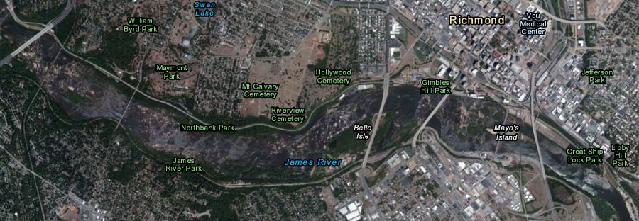
Richmond developed at the Fall Line, where rapids prevented ocean-going ships from sailing further upstream
Source: ESRI, ArcGIS Online
A year after unpacking the Susan Constant, Discovery, and Godspeed and building a fort at Jamestown, John Smith led an expedition that sailed and rowed a shallop up the James, York, Rappahannock, and Potomac rivers. The English discovered the zone of rapids and waterfalls known today as the Fall Line.
The waterfalls and rapids of the Fall Line blocked the English ships from sailing further west into the North American continent. Dreams of a Northwest Passage, permitting ships to sail through Virginia to China, did not come true.
The Fall Line is the western edge of the Coastal Plain, the physiographic province where tides affect the water level in the rivers and where ocean-going vessels can sail in the Virginia rivers. One indication of the constraint to transportation imposed by the Fall Line: Smith could not get his shallop across Little Falls near the current location of Georgetown, so he did not discover the very distinctive Great Falls further upstream.
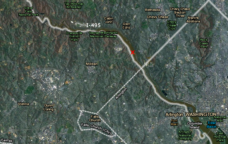
in 1608, Little Falls (red X) prevented John Smith's boat from traveling further upstream
Source: ESRI, ArcGIS Online
The English immigrants to Virginia initially settled east of the Fall Line. They cleared the forest and started plantations in the flat Coastal Plain, close to the Chesapeake Bay and with easy access by ship to Europe and the islands in the Caribbean. Because the Fall Line blocked ships from sailing further west, the English colonists focised on settling the lands on the Coastal Plain for over 125 years before they moved west upstream along the James, York, Rappahannock, and Potomac rivers into the Piedmont.
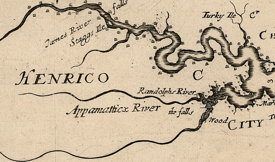
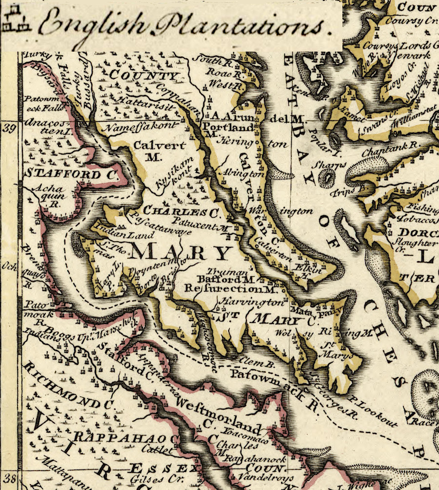
over 60 years after Jamestown was started, there were few settlers west of the Fall Line on the Appomattox and James rivers
Source: John Carter Brown Library, Virginia and Maryland As it is planted and Inhabited this present Year 1670 (by Augustine Herrman, 1670)
William Byrd II founded the cities of Richmond and Petersburg in 1732. He specifically cited his reason for choosing Fall Line locations for those new places (emphasis added):1
in 1732, William Byrd II chose the "uppermost landing" of the Appomattox River to become the city of Petersburg
Source: ESRI, ArcGIS Online
As a result of the delay in settling upstream of the Fall Line, the English disrupted and displaced the Algonquian-speaking tribes that lived in Tidewater long before seizing the lands of Native Americans that spoke Siouan or Iroquoian languages.
North and south of Virginia, the Fall Line had less of an impact on colonial settlement. The ice sheet made the Hudson River navigable for 150 miles north, allowing access for easy travel into the Mohawk River Valley.
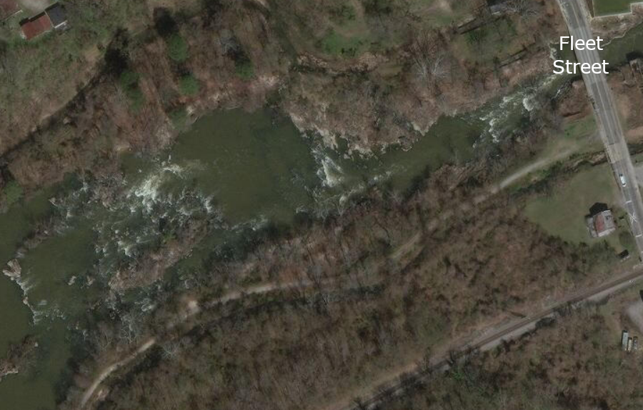
The glacial runoff in New York and Pennsylvania carved a deep channel for Delaware River, stretching from Trenton Falls south to the Atlantic Ocean. The navigable portion of the Delaware River penetrated past the Piedmont to the Great Valley west of the Blue Ridge, at the northern edge of modern Bucks County, though early ships avoided shallow water by stopping at what became Trenton and Philadelphia. Geology and topography made migration from Philadelphia through Pennsylvania into the Shenandoah Valley easier than from any port city in Virginia.2
the Delaware River is navigable into the Great Valley at the northern edge of Bucks County (red circle), but shallow upstream of Trenton/Philadelphia
Source: Pennsylvania Department of Conservation and Natural Resources, Physiographic Map of Pennsylvania
In North Carolina, the Fall Line is less distinct. The still-rising Cape Fear Arch has created a Piedmont in North Carolina that is about 600 feet higher in elevation than in Virginia. Rivers in North Carolina drop in elevation as they flow across a zone which is 30-40 miles wide. Before ships in North Carolina could reach the Fall Line, shallow water in most rivers created a barrier to upstream traffic:3
Settlement west of the Fall Line imposed a substantial transportation burden on the colonists. East of the waterfalls in the Chesapeake Bay watershed, the English could roll heavy hogsheads of tobacco from barns to a wharf and load barrels of "smoking leaf" directly onto ships headed to Europe.
into the mid-1700's, colonial settlement was concentrated along the shorelines of the rivers
Source: Library of Congress, A new and accurate map of Virginia & Maryland (by Emanuel Bowen, 1752)
West of the waterfalls, tobacco had to be hauled by wagon on unpaved roads to a river, loaded onto small boats (batteaux), floated to the Fall Line, moved off the small boats onto wagons, carried a few miles on unpaved roads around the waterfalls, then loaded onto ocean-going vessels at the ports below the waterfalls. The extra costs for handling bulky tobacco cut deeply into the profits of colonial farmers living upstream of the Fall Line.
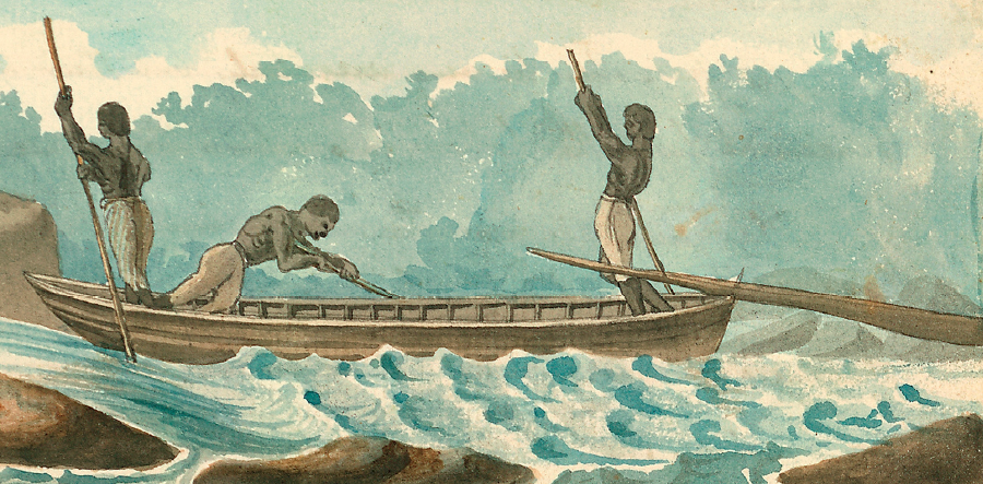
cargo could be floated through the Fall Line rapids in batteaux, sometimes by slaves
Source: Library of Virginia, Three Slaves Steering A Bateau, 1798, Watercolor (by Benjamin Henry Latrobe)
The "head" of water navigation, the rapids at the Fall Line, required captains of ocean-going ships to unload European goods. Where rivers were blocked by a rapid, warehouses were built to store tobacco before export. Imported goods were unloaded from ocean-going ships, and stores developed at the Fall Line. Customers came to the stores, or wagons would be loaded to deliver items to inland plantations. As the population of the Virginia colony increased, warehouses and stores grew and towns - Alexandria, Colchester, Occoquan, Dumfries, Fredericksburg, Richmond, Petersburg, and Emporia - developed at the Fall Line.
English colonists quickly discovered that barrier to navigation on major rivers, but were unable to sail far enough up the shallow and narrow Pamunkey and Mattaponi rivers to discover if there were waterfalls. As late as 1670, when English explorers were such as John Lederer were starting to cross the Blue Ridge, Augustine Herrman's map suggested those river lacked the mountain sources recognized at the Fall Line on the larger rivers. No significant towns developed at the Fall Line on the North Anna, South Anna, or Mattaponi rivers.
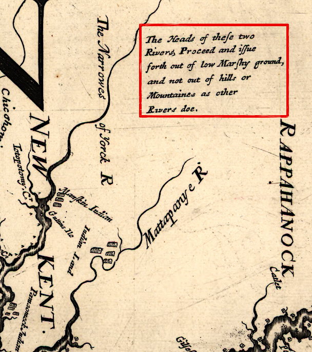
the winding, shallow channels of the Pamunkey and Mattapoini rivers delayed recognition that they also crossed the Fall Line
Source: Library of Congress, Virginia and Maryland as it is planted and inhabited this present year 1670 (by Augustine Herrman)
Later, canals were built so small boats could bypass the waterfalls, and the water in the canals was tapped for hydropower. Falling water turned wheels, and through mechanical ingenuity the turning wheels were tapped to grind grain, saw wood, and supply mechanical energy for local manufacturing.
In the days before power lines could carry electricity anywhere, factories were built near energy sources. The falling water at the Fall Line was a very attractive energy source. In the first half of the 1800's, Richmond in particular became an industrial powerhouse using waterpower to grind grain and manufacture iron products. People walked to work before the development of the streetcar in the 1880's, so factories stimulated urban population centers. The Fall Line today is marked by a string of cities stretching from Baltimore, Maryland to Augusta, Georgia.
What if there had been no Fall Line? Instead of a concentration of population in the Chesapeake Bay watershed for over a century, settlers might have rushed westward upstream from Jamestown to fill the James River valley first. That would have brought the colonists into conflict with different Native American tribes that occupied the Piedmont in the 1600's.
Instead, by the time the English moved west into the Piedmont and south into the Shenandoah Valley in the early 1700's, those tribes had already been disrupted and forced to abandon most towns. In 1714 Governor Spotswood started to consolidate remaining Siouan-speaking tribes at Fort Christanna in Brunswick County on the Meherrin River.4
There were conflicts on the borderlands between English and Native Americans in the 1700's, but few of those Native Americans were residents of Virginia. Instead, most fights on the frontier involved Iroquois raiding south from New York or Shawnee raiding eastward from Ohio.
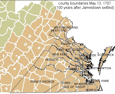
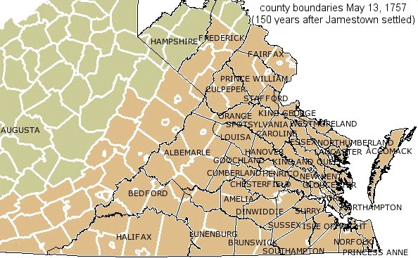
impact of the Fall Line and the Blue Ridge in the colonial settlement of Virginia is reflected in the formation of counties as immigrants moved west
Source: Newman Library - Atlas of Historical County Boundaries
If the Fall Line had been a high range of mountains, and access to international shipping had been too expensive for immigrants that crossed the mountains, perhaps colonial Virginia might have created a diversified farm economy. Colonists might have grown a range of crops that could be processed and used locally - closer to how New England developed in colonial times.
Instead, Virginia colonists on the Piedmont as well as the Coastal Plain emphasized staple production of just one crop, in quantities that could not be consumed locally and had to be sold for export. The colonists created a legal system to support the use of very cheap labor to grow that tobacco. Instead of developing a diversified economy based on small farms, Virginia farmers aspired to grow into plantation owners and supported the system of slavery.
The Fall Line has remained a regional boundary, in part because so many county boundaries were based upon it. In 2021, the Special Masters responsible for creatiing redistricting maps after the 2021 Census recognized it as an important geographic divider, relevant to defining compact and contiguous boundaries based upon communities of interest. In addition to the Blue Ridge, the Spcial Masters:5
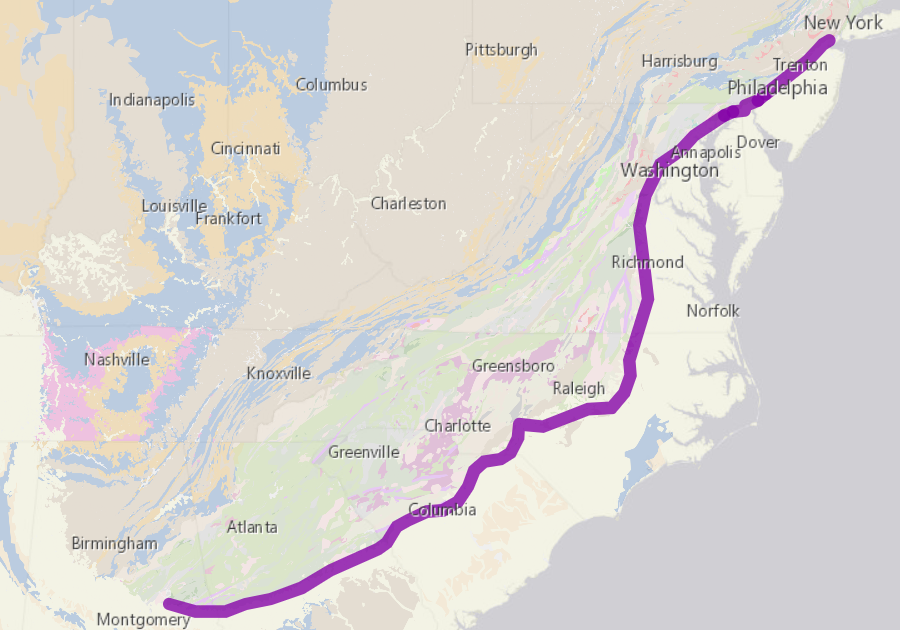
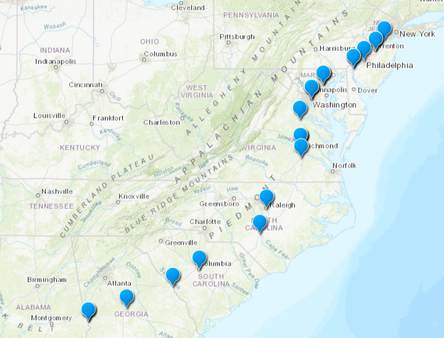
the geology-based Fall Line, the head of navigation, determined the location of what are now the first- or second-most populous cities in six states
Source: Library of Congress, How Geolgy Shapes History
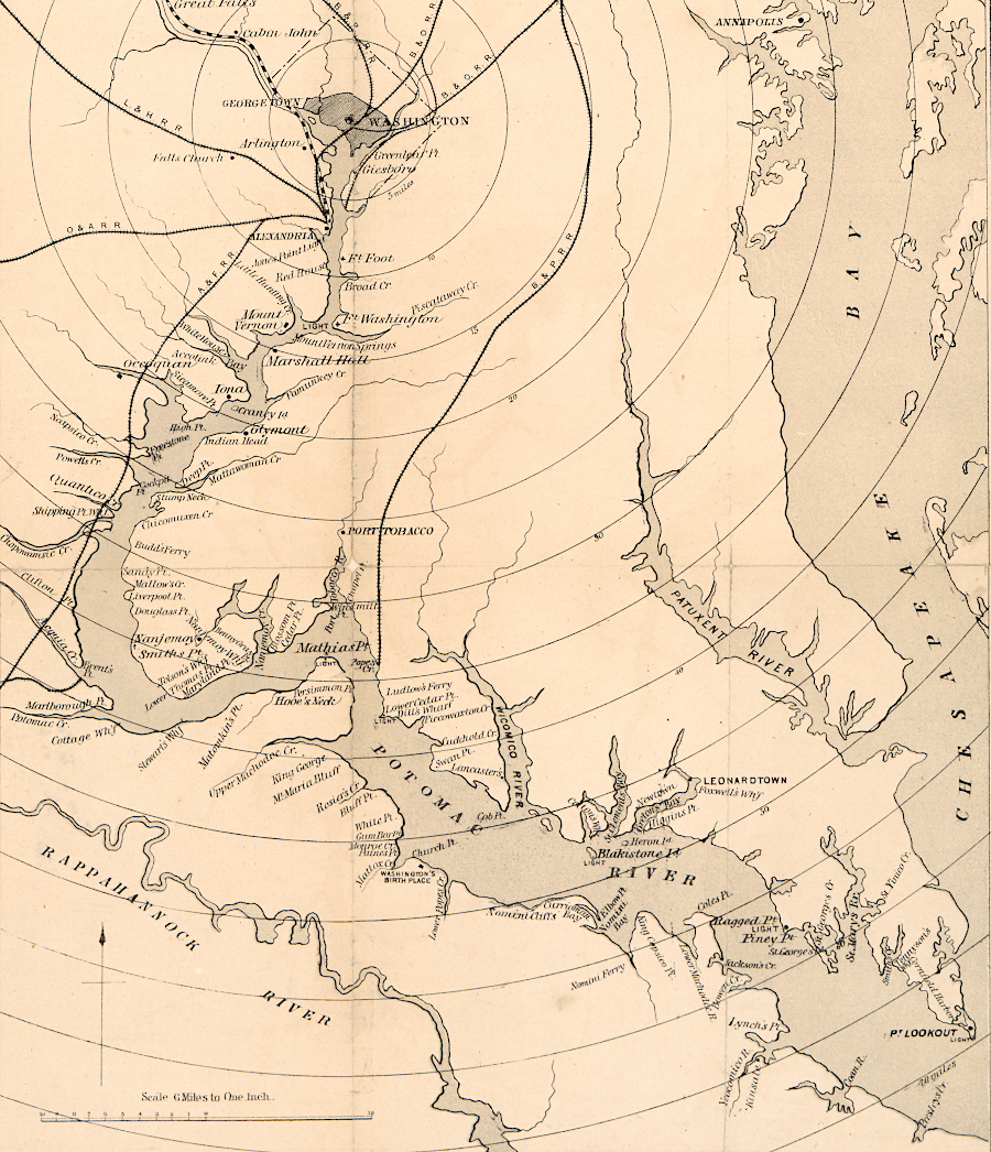
George Washington chose to place the District of Columbia at the Fall Line
Source: Library of Congress, The Potomac River from Great Falls to Point Lookout
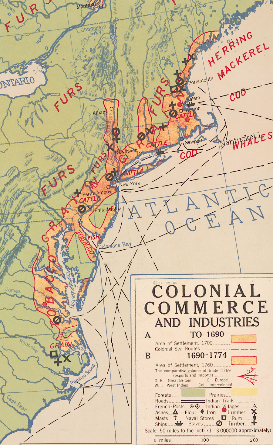
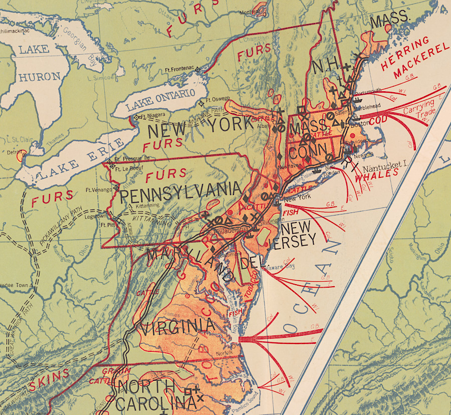
there was little settlement beyond the Fall Line in the 1600's, but it reached beyond the Blue Ridge by the American Revolution
Source: Library of Congress, Colonial commerce and industries, to (a)1690, (b)1690-1774 (Hart-Bolton American history maps, 1917)