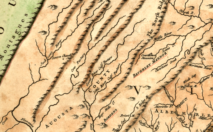
the Borden Grant was located south of Beverley Manor
Source: Library of Congress, Carte de la Virginie et du Maryland (1757)
the Borden Grant was located south of Beverley Manor
Source: Library of Congress, Carte de la Virginie et du Maryland (1757)
In May 1735, the Governor's Council in Williamsburg authorized a 100,000 acre grant to Benjamin Borden. Borden was an early immigrant into the Shenandoah Valley, coming from New Jersey.
By 1734, he lived on a 3,134 acre tract adjacent to Lord Fairfax at Greenway Court. The two appeared to have a friendly business relationship. At the time, Fairfax was contesting other land claims, saying that he - rather than colonial officials in Williamsburg - had the right to sell land in the northern part of the Shenandoah Valley.1
Borden laced the family connections of many others who obtained grants of western lands, such as William Beverley or the members of the Ohio Company and the Loyal Land Company. It is likely that Borden developed business connections as he brought goods to the Chesapeake Bay and traded with the First Families of Virginia. He was apparently on good terms with his neighbor Lord Fairfax. He may have earned the special favor of Governor William Gooch by giving him a buffalo calf.2
The land to be selected and surveyed for Borden's 100,000 acre tract was located south of the area claimed by Lord Fairfax in the northern part of the Shenandoah Valley, and south of William Beverly's grant. The petition in 1737 started with:3
Borden was unfamiliar with the territory when he first walked south in search of the land. On the way to see it one night he stopped at the home of the Ephraim McDowell family. They had come from Ulster and were planning to purchase land from William Beverley.
McDowell was a surveyor, and that evening he negotiated a deal with Borden. Borden offered 2,800 acres in exchange for McDowell building houses and a packhorse trail to Borden's grant, and validating that others had settled on Borden's land. The next day, he sweetened the deal and offered 100 acres for each cabin they built plus the right to purchase adjacent land at just 6 pence/acre. At the time, land in Pennsylvania was selling for almost 30 times that price.4
The terms of Borden's grant from the Governor's Council required him to recruit 100 settlers (one family per 1,000 acres) within two years. Borden directed all potential purchasers to McDowell, who served as his land agent.
Borden ended up receiving title to 92,100 acres after getting 92 families to build a house on his grant. So many settlers were Scotch-Irish Presbyterians that the area became known as the "Irish Tract."
Just to the north, William Grant's land grant was originally for 60,000 acres but it ended up being 118,491 acres due to a supposed surveying error. While it is possible Beverley's surveyor was unfamiliar with the territory, it is difficult to imagine how recording the metes and bounds measured each day could result in a mistake that nearly doubled the acreage. Borden was not the beneficiary of such an survey adjustment.
Getting long-term residents to live on Borden's grant would help protect the backcountry, but the grant's terms did not require Borden to sell all of his property to settlers. He was allowed to hold as much acreage as he wished, as a speculator waiting for a future increase in value. However, his profits depending upon making sales.
To attract settlers, Borden gave those who constructed a house 100 free acres. He acquired 900 acres for every 100 acres he gave to a family that settled on his grant. Once he patented the 1,000 acres per settler, he had to pay quitrents on the unsold land.
He could sell the extra 900 acres at the going market price rather than pay annual taxes, or he could absorb the annual carrying cost and gamble that land values would rise quickly. Since so much additional land was becoming available as land companies obtained new grants south of the Irish Tract, it was in Borden's interest to offer a good price. Immigrants coming from Pennsylvania had the option to keep going south, perhaps to purchase land in the New River Valley.
Broden's free 100 acres was sufficient land for a small farm, but settlers often wanted more acreage. They planned for intergenerational transfers of family wealth, so their children could each inherit enough acreage for their own farm. In the 1740's the common assumption was that the value of land would rise steadily, as population west of the Blue Ridge continued to grow.
The first 92 families to settle on Borden's grant were the first candidates to buy land:5
Borden obtained his grant when that land was within Orange County. It had the only county surveyor authorized to approve surveys west of the Blue Ridge.
Many settlers established their farms before the land was surveyed. They were not guaranteed that the 100 acres would include the land which they improved. Borden promised land to one group of 18 families whose settlement would help validate the grant, but transferred deeds to only four families before dying. Borden's son, also named Benjamin, did not consider himself bound by the promises which settlers claimed had been made but he had not heard. He refused to give the remaining 14 families the land they expected to receive.
The longest land dispute in the Borden land grant involved the family. Benjamin Borden's will included a gift of 1,000 acres of "good land" to each of his five daughters. Processing that bequest was complicated, since no single survey could encompass 5,000 acres of good land. Lawsuits among the heirs continued until 1885.6
In 1735, Benjamin Borden was a justice of the peace for Orange County. The General Assembly chartered Augusta and Frederich counties, the first two completely west of the Blue Bridge, in 1738. However, county courts were not appointed until there was a critical mass of settlers. County governments with justices of the peace were finally organized in 1743 for Frederick County and 1745 for Augusta County. Borden was appointed by the governor to serve on the Frederick County Court, but died before it began to operate.7