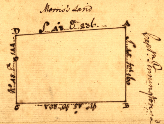
land patents were handwritten documents in the colonial era
Source: Library of Virginia, patent for Wren, James. grantee (April 5, 1773)
land patents were handwritten documents in the colonial era
Source: Library of Virginia, patent for Wren, James. grantee (April 5, 1773)
The English who settled in Virginia asserted that they owned the land through the authority granted by royal charters. While Native Americans occupied the land, the European perspective was that the occupants were not the "owners." Through the Right of Discovery and the Right of Conquest, European monarchs claimed they were entitled to allocate land to colonists without compensation to the Native Americans.
Occasionally colonists paid Native Americans for land in order to reduce the risk of being attacked but private land sales by Native Americans to individual colonists were discouraged. Some deals did end up being accepted by colonial officials, as settlers occupied lands as they were displacing the original inhabitants. The supposed sale of the land was always made under pressure. The Native Americans were unable to use the colonial courts to obtain payment or compliance with a contract except in rare cases, such as when trustees had been appointed to manage reservations.
In 1768, British officials and colonial representatives negotiated the Treaty of Fort Stanwix with the Iroquois and the Treaty of Hard Labor with the Cherokee. Those tribes claimed the right to sell hunting lands south of the Ohio River stretching westward from the Allegheny Front. The land was actually used by Shawnee, Delaware, and Mingo hunters who received none of the compensation ("presents") given to the Cherokee or Iroquois. The impacted tribes refused to accept the legitimacy of the treaties, though in 1774 the Shawnee were forced to cede their claim after being defeated in Dunmore's War.
William Claiborne did manage to purchase Kent Island in the Potomac River. He was Secretary of State and the Surveyor General for the Virginia colony. With the permission of the royal governor in 1627, he negotiated a sale from the Susquehannocks. Claiborne established a trading post on the island and exchanged manufactured goods desired by the Susquehannocks for furs/deerskins. Eventually he was forced off that land by Maryland officials. After Lord Calvert obtained his charter for the Maryland colony in 1632, Kent Island was no longer within the boundaries of Virginia.2
Jennifer Gayman Ruffner, "History of Kent Island," Kent Island Heritage Society, https://kentislandheritagesociety.org/kent-island-history/; Jack M. Sosin, "The British Indian Department and Dunmore's War," The Virginia Magazine of History and Biography, Volume 74, Number 1, Part One (January, 1966), pp.38-39, https://www.jstor.org/stable/4247178 (last checked February 16, 2026)
The most ambitious private land sales involved the Cherokee in the 1770's. Colonists settling in what today is northeastern Tennessee organized the Watauga Association and obtained authorization for occupying land which had not been ceded by the 1770 Treaty of Lochaber. William Henderson negotiated the Treaty of Sycamore Shoals in 1774-1775 to acquire 20,000,000 acres for the Transylvania Company in exchange for five wagonloads of trade goods.3
Jared Dease, "Primary Source: The Transylvania Purchase and The Treaty of Sycamore Shoals, March 17, 1775," Anchor (A North Carolina History Online Resource), 2024, https://www.ncpedia.org/anchor/primary-source-transylvania; W. Calvin Dickinson, "Watauga Association," Tennessee Encyclopedia, https://tennesseeencyclopedia.net/entries/watauga-association (last checked February 8, 2026)
To minimize expensive conflict and to speed settlement, treaties were negotiated with different tribes in the 1600's and 1700's to extinguish Native American claims. Virginia's colonial government negotiated all "official" land cessions from Native Americans.
Major treaties after the 1622 and 1644 uprisings led to defined areas where Native Americans were excluded. Several reservations were established in the 1660's and early 1770's for Native American tribes to retain townsites, corn fields, and nearby hunting/trapping territory. All but the reservation of land for the Pamunkey and Mattaponi tribes were eventually abolished, with the land sold to nearby white residents.
Major negotiations in the 1722 Treaty of Albany, 1744 Treaty of Lancaster, 1768 Treaty of Fort Stanwix, 1770 Treaty of Hard Labor, and 1770 Treaty of Lochaber led to cessions of Native American claims by the Iroquois and Cherokee to the western lands which Virginia also claimed. After Dunmore's War in 1774, the Shawnee, Delaware, and Mingo ceded lands south of the Ohio River in the Treaty of Camp Charlotte.
Those treaties were one-sided bargains; land was essentially seized rather than purchased from the original inhabitants. In some cases, such as the 1768 Treaty of Fort Stanwix and the 1768 Treaty of Hard Labor, land was "purchased" from tribes which has only a vague claim to the territory. The Haudenosaunee (Iroquois) and Cherokee got paid for land that was being used primarily by the Shawnee, Delaware, and Mingo. They were not compensated for the cession of their hunting territory.
From the beginning, violence accompanied land theft from the Native Americans. In the early 1600's, agressive land-seeking colonists would simply move into territory used by Tidewater tribes after hogs had been released to destroy the cornfields. That triggered two uprisings in 1622 and 1644 led by Opechancanough, leader of the 30+ tribes in the paramount chiefdom whose land was being seized.
Violence was initiated a third time in 1676. In that case the land hunger, as settlers pushed deeper into hunting territory and displaced Native American towns, triggered a civil war among the colonists. After Susquehannocks raided along the edge of settlement in Stafford County, the English living far from Jamestown felt Governor William Berkeley and the Governor's Council were refusing to provide adequate military protection. Nathaniel Bacon led an uprising of mostly tenant farmers and indentured servants who burned Jamestown before being defeated.
Throughout the colonial period, European immigrants steadily converted the forests into farmland. The destruction of hunting territory spurred conflicts with those who had traditionally used the land. The Native Americans in the Mississippi River watershed were able to obtain guns and gunpowder from the French, and the threat of a raid on an isolated farm deterred all but the most land-hungry settlers from moving further west.
The withdrawal of the French at the end of the French and Indian War in 1763 changed the ability of western tribes to resist encroaching settlement. Pontiac's War, which started in 1763, was a last-ditch effort of tribes in the Ohio River watershed to block colonists from surveying and settling in that region. That war did succeed in getting King George III to issue the Proclamation of 1763. That proclamation was intended to limit settlement to just east of the Mississippi River watershed divide and keep the tribes peaceful. However, colonial officials and British Regulars stationed at western forts failed to enforce the proclamation line.
The land hunger of American colonists was a driving force in western migration to the Pacific Ocean, an expansion labelled as "manifest destiny" in the 1840's.
Clearing land for farms always disrupted Native American hunting grounds. Warfare started almost as soon as English colonists began to occupy "vacant" land at Jamestown. The paramount confederacy led by Powhatan was destroyed within 40 years of the arrival of the Discovery, Godspeed, and Susan Constant in 1607. Almost all Native America groups were forced to move west of the Mississippi River. Almost all fought that displacement and were defeated.
At the end of the colonial period, the frustrated royal governor of Virginia wrote to his supervisor in London that the backwoodsmen "are Hunters like the Indians and equally ungovernable" and:2
Jim Glanville, "The Fincastle Resolutions*," The Smithfield Review, Volume XIV, 2010, p.82, https://vtechworks.lib.vt.edu/server/api/core/bitstreams/672b0c83-5d0c-4bed-85f0-57599c7a60b1/content (last checked January 2, 2026)
According to real estate law in Virginia, the chain of title for parcels begins with colonial records created by the English. The original ownership of land by the indigenous inhabitants is not the acknowledged starting point.
In the colonial period, individual colonists acquired title to real property first through grants from the Virginia Company. Land transfers were later authorized by headrights, treasury rights, military warrants, plus grants made by royal officials and the Governor's Council to individuals and groups.
Three charters issued by James I did acknowledge the land claims of the Spanish in the New World based on prior settlement by Christians, even though they were Catholic. The first charter issued to the Virginia Company in 1606 authorized the investors "
In the Second Charter issued in 1609, the Virginia Company obtained legal title (as seen by European-centric lawyers) to all the land "from Sea to Sea West and North-west." The Third Charter in 1612 granted the Virginia Company all lands between 34-41 degrees.1
"The First Charter of Virginia; April 10, 1606," Avalon Project at Yale Law School: Documents in Law, History and Diplomacy, http://avalon.law.yale.edu/17th_century/va01.asp (last checked February 2, 2016)
The first English who reached Jamestown were investor in or employees of the Virginia Company. The investors owned all the land graned by the king, not the employees. Total ownership of Virginia by one company was altered starting in 1613 when the Virginia Company began to issue land titles to individuals. If a landowner died without heirs, the private land was escheated back to the Virginia Company.
After King James I revoked the Virginia Company's charter in 1624 and Virginia became a royal colony, the monarch owned all of Virginia. The process of privatizing land started with the transfer out of royal ownership.
The Virginia Company, which expired in 1624, was never a successful business despite its massive real estate portfolio. The company had higher costs than revenues because, unlike in the Spanish colonies, there was no immediate wealth to be seized. English colonists found no gold on the Coastal Plain of Virginia, and the paramount chiefdom led by Powhatan offered no stockpile of wealth to steal.
The Virginia Company could not replicate the success of the Spanish who extracted vast wealth already accumulated by organized Native American societies in Mexico and Peru. When Captain Christopher Newport sailed back to England from Jamestown on June 22, 1607, the Susan Constant and Godspeed carried only lumber and barrels of dirt that was thought to contain valuable minerals. The Coastal Plain dirt contained only sparkly grains of mica, feldspar and quartz.
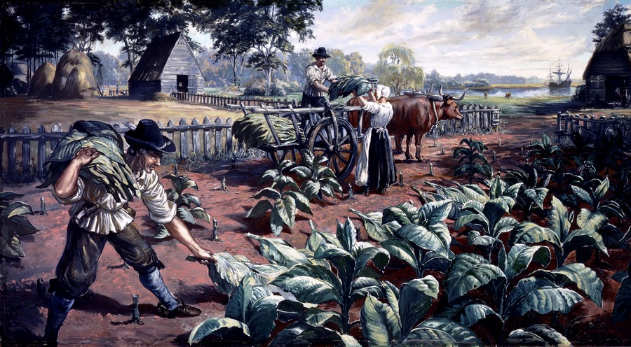
John Rolfe finally demonstrated how the Virginia Company could make a profit by shipping tobacco back to England. His crop was grown from Nicotiana tabacum seed that might have been acquired while shipwrecked on Bermuda in 1609-1610, but more likely came from sailors who visited Jamestown in 1611 or 1612. He sent his first sample to England in 1613, followed by four barrels for sale in 1614.
Rolfe demonstrated that there was a demand for tobacco grown in Virginia. His seeds produced tobacco leaves that were not as bitter as the Nicotiana rutica leaves grown by the Native Americans; his product could displace the tobacco imported from Spanish colonies in the Caribbean. Profits from tobacco helped the Virginia Company recognize that agriculture, rather than the discovery of minerals or the hypothesized Northern Passage, could generate a positive return on investment in company shares.
Farming was the answer. The investors had land to grow tobacco in Virginia and customers to buy tobacco in England.
Land became valuable because the more acres that were planted, the greater the tobacco harvest. The crop required large amounts of freshly-cleared land because tobacco exhausted key nutrients in the soil (especially nitrogen). Growing tobacco involved abandoning old fields after just 2-3 years and clearing trees to plant new fields.
Land was plentiful once the Native Americans were displaced; labor was scarce. Large numbers of workers were needed to plant, weed, and harvest the crop. Processing, packing, and shipping the annual crop were also labor-intensive operations. Men who accumulated a labor force of indentured servants and later enslaved workers had to acquire enough land, year after year, to guarantee that the expensive labor force could be used effectively.2
"The Third Charter of Virginia; March 12, 1611," Avalon Project at Yale Law School: Documents in Law, History and Diplomacy,, http://avalon.law.yale.edu/17th_century/va03.asp; "Starving Settlers in Jamestown Colony Resorted to Cannibalism," Smithsonian Magazine, April 30, 2013, https://www.smithsonianmag.com/history/starving-settlers-in-jamestown-colony-resorted-to-cannibalism-46000815/; David A. Price, Love and Hate in Jamestown: John Smith, Pocahontas, and the Start of a New Nation, 2007, p.186, https://www.google.com/books/edition/Love_and_Hate_in_Jamestown/_EFbS_7fFcYC (last checked February 7, 2026)
At the same time that tobacco revealed a way to make a profit in Virginia, the Virginia Company was struggling to find new people willing to be transported across the Atlantic Ocean as indentured servants. Emigrating to Virginia was a high risk decision. When Captain Christopher Newport returned to Jamestown with the First Supply in Jamestown in 1608, only 38 of the 104 colonists which he had left behind were still alive.
Negative reports from returning colonists discouraged even the poor in England from choosing to go to Virginia. After the Starving Time of 1609-1610, Lord de la Warre (as governor) and Sir Thomas Gates (as first marshal) had turned Jamestown into an armed camp with military discipline. They issued "Laws Divine, Moral, and Martiall" to control the behavior of the company's employees and soldiers. Moving to Virginia to suffer as an indentured servant was not an attractive choice for people in England.
The Virginia Company needed to change the dynamic. Owning a massive block of land in Virginia generated no profit for the investors unless there were farmers growing tobacco on that land. The investors needed to increase immigration to Virginia, and to decrease emigration of servants who had lived long enough to complete their time of required service and become free.
The company adapted in several stages. Investors retained dreams of finding valuable minerals or generating profits from manufacturing items in Virginia such as glass, but the revised business plan took advantage of the company's greatest asset - its ownership of a vast amount of fertile land.
In 1613, Governor Sir Thomas Dale began to grant three-acre parcels to colonists willing to stay after their seven-year indentures expired. Those who stayed could work for themselves on their private three-acre plots, rather than becoming farm laborers on the company's land.
In 1616, colonists in Virginia ("ancient planters") were given 50 acres in exchange for remaining rather than returning to England. Since the Virginia Company had no cash to distribute as a dividend in 1616, investors in England were also each given rights to claim 50 acres. An additional 50 acres were granted for each new share purchased in the joint stock company, for twelve pounds (£10) and ten shillings per share. The right to purchase land, in exchange for a payment of twelve pounds ten shillings into the company's treasury, established the principle of land sales for cash.3
Fairfax Harrison, Virginia Land Grants, Old Dominion Press, 1925, p.16, https://books.google.com/books/about/Virginia_Land_Grants.html?id=XyZBAAAAIAAJ (last checked December 5, 2025)
Any additional investment in the company became a speculation on the value of the land rather than on the potential for company profits from manufacturing, mining, or trading.
In 1617, the company declared that all new immigrants to the colony who paid their own costs for transportation would be rewarded with 50 acres of land. Immigrants unable to pay their own costs would also be worth 50 acres each, but the immigrant would not get that land.
For each new immigrant ("head"), the company granted a "headright" to survey and own 50 acres of land to the person who financed the trip. The headrights could be sold, so ship captains and could sail home with cash for investors rather than paper claims to land that they did not desire to own.
The headright system provided free land to the person who paid for transportation, but transportation costs were as high as six pounds per person in the 17th Century. Those owning land were supposed to pay one shilling per 50 acres in annual property taxes, known as quitrents.
Englishmen interested in a free trip to Virginia could sign contracts to provide seven years of labor, earning 50 acres of land at the end of their term of service. The opportunity to own land was the primary attraction for colonists to risk a trip across the Atlantic Ocean to the colony in Virginia in the Seventeenth Century. In England, social and economic mobility was limited. Few of the farmworkers had an opportunity to acquire land and enter the gentry class. Travel to Virginia was risky, but the chance to end up as a landowner provided strong motivation.
In 1618, the dividend was increased to 100 acres/share. Colonists who had financed their own trip to Virginia before 1616 were also given rights to claim 100 acres. To qualify, new colonists had to stay three years (or die in Virginia before three years were completed). The first 50 acres would be distributed in an initial division of land, and the additional 50 acres would be distributed once the initial division of land was occupied by colonists:4
"Instructions to George Yeardley," Virginia Company of London, November 18, 1618, posted online by Encyclopedia Virginia, http://www.encyclopediavirginia.org/_Instructions_to_George_Yeardley_by_the_Virginia_Company_of_London_November_18_1618; Paul W. Gates, History of public land law development, Public Land Law Review Commission, p.35, https://hdl.handle.net/2027/uc1.32106000891595?urlappend=%3Bseq=53%3Bownerid=9007199266889467-57; Martha W. McCartney, "A Study of Virginia Indians and Jamestone: The First Century," Colonial National Historical Park, National Park Service, December 2005, https://npshistory.com/publications/jame/moretti-langholtz/chap4.htm (last checked February 8, 2026)
The Virginia Company also invited investors to create "particular plantations" or "hundreds" in the colony, separate from the company-managed communities such as Jamestown and Henricus. The company granted large amounts of land to investors willing to recruit settlers and establish new communities in the colony. Those communities would not be responsible to company officials; decisions made by the General Assembly meeting in Jamestown would not apply to the particular plantations.
The settlement of Bermuda set an example of providing investors some extra control over the settlements they sponsored. The island was surveyed and specific parcels of land called "tribes" (later called "parishes") were allocated to individual investors.
In Virginia, those who established particular plantations could also be company officials. The decision to create independent units within the colonies created confusing loyalties and conflicts of interest, but did stimulate investors to provide new funding and increase the size of the agricultural labor force.
An investor who chose to fund a particular plantation rather than buy more shares in the Virginia Company was betting on the success of colonizing Virginia, independently from betting on the success of the Virginia Company. Tobacco could be grown and shipped to market in Europe. Farming privately-owned land minimized the risks that the Virginia Company might not be profitable.
to maximize profit from tobacco production, colonial investors acquired title to private parcels separate from the Virginia Company's lands
Source: Colonial National Historical Park, National Park Service, Tobacco Production
By creating private land rights, the London Company traded total control over its land in exchange for profits from handling tobacco and collecting the equivalent of property taxes ("quitrents") at the rate of 2 shillings/100 acres. Selling land was a long-term strategy. Collection of quitrents could be deferred initially to encourage new immigrants who would help defend against Native American attack or repel a sea-based raid by a European rival.
The Virginia Company loosened its control even more in 1618. A faction of investors led by Sir Thomas Sandys outmaneuvered its opponents in the company. They forced Sir Thomas Smith out of the role of Treasurer, which was equivalent to Chairman of the Board and Chief Executive Office, and issued the 1618 Charter of Orders, Lawes, and Privileges.
That "Great Charter" was a set of instructions from the investors in London, not a fourth charter from the king. It gave greater responsibility for local government to the colonists, and authorized the first General Assembly which met in 1619. Shipments of women to Virginia, starting in 1619, were intended to transform a military-controlled colony into a welcoming place to raise a family. Under Sir Thomas Sandys, the Virginia Company expected that granting land and freedoms to colonists would increase the population enough so investors could finally make a profit.5
Frank E. Grizzard, D. Boyd Smith, Jamestown Colony: A Political, Social, and Cultural History, ABC-CLIO, Santa Barbara, 2007, p. 189-xliv, http://books.google.com/books?id=555CzPsGLDMC (last checked August 10, 2009)
Governor Wyatt issued patents to land based on headright claims until the Virginia Company failed. After King James I revoKed the company's charter and took direct control of the colony in 1625, his appointed royal governors continued to issue headrights. The colony, rather than the private company, was supposed to collect the annual quitrents of 2 shillings/100 acres.
Quitrents were based upon the concept that the King of England or a feudal lord was entitled to require a person to provide military services in exchange for the right to live on the land. That claim could be replaced by the resident's agreement to pay quitrents instead. The authorization of quitrents, with land held in "free and common soccage" without a commitment of personal service, permitted a resident to sell the right to live on the land.
So long as the next owner paid the quitrents, land tenure no longer was limited to just members of a family who accepted the obligation to serve a feudal lord when he assembled an army. Selling land enabled peasants to move away, and not be accessible when the landlord needed soldiers. Quitrents facilitated the creation of a real estate market, with willing buyers and sellers who did not need the lord's permission for a transaction. If quitrents were not paid, the land was escheated to the colonial government and could be sold again.
In the Virginia colony, quitrents were supposed to be collected by the local sheriff. The quitrents were used to defray the costs of collection and for administrative costs of the colony. The sheriff was entitled to a percentage of the quitrents that he collected as payment for his work. The salaries of the colonial governor and other appointed officials were funded by collected quitrents and a variety of fees, including payments by ship captains bringing imported goods (tariffs) and a tax on hogsheads of exported tobacco.
Quitrents were based on land ownership. Per-capita (capitation) taxes also covered colonial expenses. Not until the beginning of the American Revolution did England plan to pay colonial officials from the treasury in London.
Lord Fairfax inherited a proprietary land grant including the Northern Neck, so he paid no property taxes to the colonial officials in Williamsburg. He was entitled to collect the quitrents from the parcels which he sold within his grant between the Rappahannock and Potomac rivers. Collection of quitrents on lands outside of the Fairfax Grant ended in 1777. Practically, the 1777 law also ended quitrent collection within the Fairfax Grant by allowing anyone who paid a quitrent there to deduct it from their taxes.
The award of 50 acres for everyone imported into Virginia incentivized wealthy individuals to find and transport new immigrants as indentured servants to Virginia. Within 50 years, 70,000 people came to the Chesapeake region. In the 1600's before the expansion of slavery, 75% of the immigrants to Virginia arrived as indentured servants.6
Bernard Bailyn, The Barbarous Years, 2012, Alfred A. Knopf, p.79, https://books.google.com/books?id=TcDQWS16BLYC; Thomas Perkins Abernethy, Three Virginia Frontiers, Peter Smith, 1962, p.54, https://books.google.com/books?id=XmgatAEACAAJ; Alvin T. Embrey, Waters of the State, Old Dominion Press, 1931, pp.3-4, https://archive.org/details/watersofstate00embr; "socage," Britannica, https://www.britannica.com/topic/socage; Manning C. Voorhis, "Crown Versus Council in the Virginia Land Policy," The William and Mary Quarterly, Volume 3, Number 4 (October, 1946), pp.500-501, https://doi.org/10.2307/1921901 (last checked February 11, 2026)
convicts imported to Virginia qualified for the award of headrights
Source: Virginia Chronicle, Virginia Gazette (December 17, 1772, p.4)
Indentured servants signed contracts obligating them to work 3-7 years. They basically traded several years of labor for a trip across the Atlantic Ocean and a chance to make a new start. Servants who lived long enough to reach the end of their term of indenture were supposed to be given some basic clothing and farming equipment, but were not given land. Royal governors, influenced by the members of the Council of State/Governor's Council, did not implement instructions from England starting in 1639 to provide free land to indentured servants at the end of their service term.6
Manning C. Voorhis, "Crown Versus Council in the Virginia Land Policy," The William and Mary Quarterly, Volume 3, Number 4 (October, 1946), p.501, https://doi.org/10.2307/1921901 (last checked February 11, 2026)
Immigration was key to expanding the acreage of farmed land that produced crops which could be sold at a profit. Clearing the forest required hard work that was essential to enable sunlight to reach the ground; tobacco, corn, wheat, hemp, and other agricultural crops do not grow in the shade. New farms moved the edge of English settlement steadily inland, further west into the North American continent. More workers and more farmed acreage increased the tonnage of tobacco exports, and the Virginia tobacco business enriched the English merchants who exerted great influence in Parliament.
An investor acquired land by funding transport of an immigrant and claiming the 50-acre headright, not the person who actually worked the land for years. There was no automatic grant of land to indentured servants after they completed their term of indenture, and certainly not to those were were enslaved starting in 1619. Indentured servants who completed their years of obligatory service and wanted to own a farm had to acquire capital or get a landowner to mortgage property in order to purchase some acres.
Many indentured servants ended up spending their entire lives as farmworkers and never acquired any land. It was common for a recently-freed indentured servant to continue to work for the same landowner as a paid farmhand.
Freed indentured servants had three standard choices: pay for a trip across the Atlantic Ocean and return to England, negotiate a deal to work as a farm laborer for a landowner in exchange for housing and wages, or find unclaimed land on the edge of settlement and become a squatter.
Some indentured servants managed to use the fourth choice and purchase low-cost land on credit, then "improve" the land by cutting down the trees and preparing fields suitable for growing crops such as corn and tobacco. Those with influence with the colonial government, and who obtained a land grant, had an excess of acres - more land than they could put to productive use with the available labor. Former indentured servants were cash poor, but landowners were willing to sell parcels based on credit.
In a few years a new farmer might generate enough surplus income to pay off the land - assuming the former indentured servant was healthy enough, lived long enough, weather conditions allowed for harvesting a successful series of crops, and demand from customers for those particular crops kept prices higher than production costs.
Land ownership was the dream of many of those in England who signed indentures. The potential to become a landowner in Virginia was far greater than in England, at least until the population decline in 1660's due to the plague. The risks were high, but so was the value of acquiring wealth and starting generational transfer to decendants.
By 1624, Virginia was a colony with an economy based on land speculation as well as tobacco production. Land values depended upon increasing immigration. When someone acquired title to large blocks of land at a low cost per acre, their investment in land became successful only after they found settlers willing to pay a higher price per acre for small parcels.
The gentry, the elite landowners, were the wealthy 5% at the top of Virginia's stratified society. A small percentage of immigrants from England did bring enough money to buy land immediately. The "Cavaliers" were supporters of King Charles I who moved to Virginia during the English Civil War that erupted in 1642. They arrived with sufficient wealth to purchase headrights, aquired legally or otherwise, and acquire a labor force to start a plantation.
With enough servants or enslaved workers, the gentry could generate profits from farmed land while speculating that their excess property would gain in value over time. Yeoman farmers in England were willing to sign an indenture and commit to work for someone else for 5-7 years in Virginia because they were being displaced from estates. The farmers were being forced to move because English landowners were shifting to farming practices, including wool production, which required less labor.
Into the 1800's, Virginia had an excess of land and a shortage of people. Since the first private plantations were authorized by the Virginia Company, Virginia's economic elite encouraged population growth through immigration. The potential to acquire land was sufficient to induce immigration to Virginia along with peaks of people fleeing European wars, religious persecution, and hunger.
Using land to incentivize immigration was not limited to the colonial era or Virginia officials. The United States offered free land through the 1864 Homestead Act to encourage immigration to the unsettled western area. The US Congress granted large swaths of land to railroads in a checkerboard pattern parallel to the tracks, so the private sector would seek out immigrants to buy that land.
The Homestead Law, which was repealed in 1976 with passage of the Federal Land Policy and Management Act, and railroad grants was never applied in Virginia. The national government never owned any unclaimed public land in Virginia to give away. The state assumed ownership of all vacant land from the royal government when the Fifth Virginia Comnvention declared independence in 1776.
Land once claimed by Virginia was sold by the national government after the state ceded the Northwest Territory to the Continental Congress. The national government disposed of that former Virginia land through a variety of techniques, starting in Ohio after passage of the Land Ordinance of 1784 and the Land Ordinance of 1785.8
"V. The Ordinance of 1784, 23 April 1784," Founders Online, National Archives, https://founders.archives.gov/documents/Jefferson/01-06-02-0420-0006; "National Timeline," Bureau of Land Management, https://www.blm.gov/about/history/timeline (last checked February 8, 2026)
in the Northern Neck, Lord Fairfax could sell land in whatever sized parcels he wished, without regard to headrights or treasury rights
Source: Library of Virginia, patent for Crossthwait, William. grantee. (November 10, 1751)
The headrights system lasted from 1618 until cancelled by the General Assembly in 1779, when the Land Office re-opened in the middle of the American Revolution. Starting in 1699, after European immigrants became harder and harder to attract, the colony began to sell "treasury rights." Purchasers could buy 50 acres for 5 shillings without having to pay the higher cost to transport an immigrant across the Atlantic Ocean.
Treasury rights were developed as a mechanism to increase revenuee for the royal government. When Governor Francis Nicholson arrived in 1698, he was instructed to dispose of land only if it was going to be settled by actual farmers who would pay quitrents rather than sequested by the colonial elite for future sale. The process for surveying parcels was also revised by the "The Duty of Surveyors" legislation approved by the General Assembly in 1706. The role of the Surveyor General was replaced by county surveyors wjo had to approve every survey before a patent would be granted for a parcel being patented (transferred into private ownership). Surveyors had to be licensed by the College of William and Mary.8
Library of Virginia, "Headrights," VA-NOTES, http://www.lva.lib.va.us/whatwehave/local/va4_headrights.htm; Jim Glanville, "William Preston the Surveyor and the Great Virginia Land Grab," Smithfield Review, Volume 17, 2013, p.51-52, https://holstonia.co/knowledge-base/william-preston-the-virginia-land-grab-colonial-surveying-legacy/ (last checked February 11, 2026)
The process of converting a headright or treasury right into a deed documenting land ownership involved several steps. In theory, the process allowed only valid headright or treasury right documents to be used to acquire land. In practice, validation was accompanied by fraud and confusion regarding legitimacy. Surveyors manufactured parcel boundaries that incuded more acreage than was authorized, while local courts issued duplicate certificates for headrights.
Land was stolen from the monarchs, but they were 3,000 miles away and their appointees were willing to accept the theft. Appointed governors "connived" at the techniques used to dispose of excessive amounts of land. The loss of colony-owned land was a pardonable crime because the governors needed the cooperation of the colonial leaders to fulfill other directives in the instructions from the Board of Trade. Land speculators were willing to commit to paying quitrents on land which was left unoccupied, so from a governor's point of view the colony was a non-producing asset for annual revenue.8
James Blair, The Present State of Virginia, and the College, Colonial Williamsburg, 1940, pp.17-18, https://archive.org/details/presentstateofvi0000hart; Manning C. Voorhis, "Crown Versus Council in the Virginia Land Policy," The William and Mary Quarterly, Volume 3, Number 4 (October, 1946), pp.503-504, https://doi.org/10.2307/1921901 (last checked February 11, 2026)
English society in colonial Virginia was always socially stratified. In the beginning, the officers of the Virginia Comnpany controlled the wealth and made the decisions. In the 1630's, the emerging elite had sufficient political power to "thrust out" Governor Harvey.
Starting in the 1640's, Governor Berkeley consciously recruited the younger sons of the wealthy in England, offering a refuge for supporters of King Charles I and Charles II. Those immigrants arrived with sufficient assets to purchase headrights and establish plantations farmed by indentured servants, and with sufficient social status to have Governor Berkeley grant them land. Income from farming, particularly tobacco, increased as more land in Tidewater east of the Fall Line was privatized and converted from forests into fields.
The recruitment of royalists and indentured servants, plus the addition on Africans brought involuntarily, caused Virginia to become the English colony with the largest population in North America. Just before Governor Berkeley arrived at Jamestown, there were about 14,000 people in Massachusetts and only 50% of that number in Virginia. Three decades later, near the end of his term, Virginia had 40,000 colonists and Massachusetts had 30,000. Between them, they had 60% of the total colonial population.
By the end of the 1600's, about 20 "First Families of Virginia" were intermarrying and developing a dominant role in governing the social, econimic, and political life in the colony. During the period when land transfers were managed through headrights and grants from the royal governor, they created a hierarchical and class-stratified society:8
"Governor William Berkeley: Virginia's First Economic Developer," Journal of Applied Research and Economic Development, Council for Community and Economic Research, https://journal.c2er.org/history/1-3-virginia-settlement-piedmont-the-germans-scots-irish/; Ronald L. Heinemann, John G. Kolp, Anthony S. Parent Jr., William G. Shade, Old Dominion, New Commonwealth: A History of Virginia, 1607–2007, University of Virginia Press, 2008, a href="https://www.google.com/books/edition/Old_Dominion_New_Commonwealth/GQGFjKy_5OsC">https://www.google.com/books/edition/Old_Dominion_New_Commonwealth/GQGFjKy_5OsC (last checked February 12, 2026)
The land transfer process from colonial to private ownership started when the person claiming headrights went to a county court and got the justices to certify how many people had been imported. That certificate of importation would be provided to the Secretary of the colony in Jamestown and, after 1699, in Williamsburg. The Secretary then issued a document, a "right," certifying how many acres were authorized for survey. After 1699, a person could purchase a treasury "right" directly from the Secretary without claiming to have brought any human to Virginia.
The documentation from the Secretary, the "right" based on importing people (headright) or a purchase (treasury right), would be delivered to the county surveyor. That surveyor, or a deputy surveyor hired to do the work, would identify parcels matching the total acreage authorized. The county surveyor, an appointed official responsible to the county court, had to approve the survey (for a fee) before it was delivered to the Secretary of the colony in Jamestown/Williamsburg.
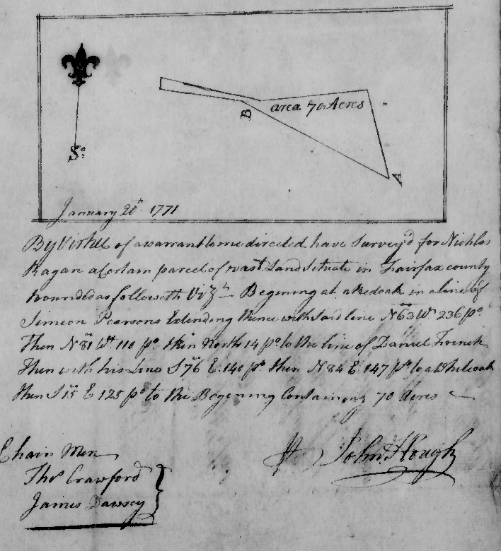
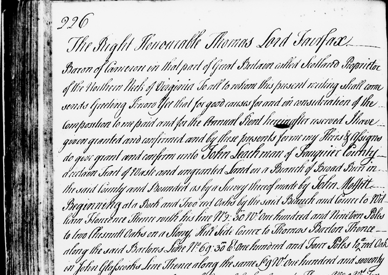
colonial surveys were simple documents, referencing features on the ground such as red oak trees
Source: Library of Virginia, survey for Wren, James. grantee (April 5, 1773)
The Secretary of the Colony prepared a "patent" (land deed, known later as a "grant") based on the survey. He kept one copy and forwarded another to the Governor. After the Governor approved the patent, the copy would be delivered to the new landowner.
The chain of title starts with the patent issued by the Secretary and bound into books at his office. Land was subdivided, re-surveyed, and re-sold over the years, but the Secretary was not involved in subsequent land transfers. Later deeds and surveys documenting new parcels and new ownership were recorded in the files of just the local county court.
Once a patent was issued, the land was supposed to be settled within a period of three years. Unless trees were cleared and crops planted, ownership was supposed revert back to the colony. That requirement was designed to spur settlement and deter land speculation, and affected individual "minor" grants. Land owned by someone who died without heirs was "escheated" back to the colony and then became available for purchase.
In theory, but not in practice, land which was not actually settled within three years was supposed to be returned to the colony. Both those acquiring land and the colonial officials responsible for the process were willing to bend, twist, and ignore legal requirements in order to maximize the opportunities to transfer acreage out of the colony's ownership.
Abuses of the system included allowing people to file illegitimate claims for headrights. In straightforward corruption, a claim could be filed for more immigrants than actually arrived on a ship. In exchange for other favors, county officials and clerks working for the Secretary of the Colony could award illegitimate headrights by not checking the paperwork closely.
Sometimes both a ship captain and a person paying the transportation costs obtained headrights for the same individuals transported to Virginia:7
"The Land Grant System in Early Virginia," The Coleman Family, Rootsweb, December 27, 2007, https://freepages.rootsweb.com/~mobjackbaycolemans/genealogy/v03landgrant.htm (last checked February 8, 2026)
Unpaid labor enriched the gentry. Virginia planters who imported slave labor from the West Indies or directly from Africa were awarded 50 acre hreadrights per enslaved person, just as they were awarded 50 acres per indentured servant. Trips across the ocean were financed by speculators to bring people to the colony for sale. If both the captain and the purchaser managed to claim a headright, an imported person could be worth 100 acres.
George Menefie was the first to claim a large number of headrights for one shipment of slaves. He acquired 1,150 acres for the 23 slaves he imported along with 37 white indentured servants in 1638. The headright claims for the servants listed the names of the individuals, but headright claims for slaves rarely identified the names of individual slaves.7
Laura A. Croghan, "'The Negroes to Serve Forever': The Evolution of Blacks's Life and Labor in Seventeenth-Century Virginia," Masters Thesis, William and Mary, 1994, p. 18-20, https://scholarworks.wm.edu/cgi/viewcontent.cgi?article=5602&context=etd (last checked April 27, 2025)
The rules were applied differently to larger grants. Land speculation was a major part of the gentry's acquisition of wealth and power throughout the colonial period.
The son of King Charles I awarded the largest land grant in Virginia. King Charles II was rallying supporters to eventually defeat the Puritans led by Oliver Cromwell, who had deposed Charles I and executed him. In September 1649 the son, who was in exile in France, awarded all the land between the Potomac and Rappahannock Rivers to seven supporters. Eventually the sixth Lord Fairfax inherited all the claims. After the boundaries were defined by surveys in the mid-1700's, the Fairfax Grant totaled 5.2 million acres.
The Fairfax Grant could have been dwarfed by the Vandalia grant to the Great Ohio Company. The land speculators in that company came close to being awarded 20 million acres in 1774. Political rivalries in London delayed the final action required for the massive grant, and then the American Revolution eliminated the capacity of King George III to give away lands in the Ohio River watershed. Had the British won the American Revolution, the acreage of that grant might have been reduced in order to provide land bounties to loyalists and British Regulars who enlisted to fight the rebellious colonists.
The royal governor had the authority to issue grants until 1710:10
Warren R. Hofstra, p.1286, "'The Extention of His Majesties Dominions': The Virginia Backcountry and the Reconfiguration of Imperial Frontiers," The Journal of American History, Volume 84, Number 4 (March, 1998), p.1286, https://doi.org/10.2307/2568082 (last checked February 8, 2026)
Governor Spotswood and his Council of State gave large land grants in the Piedmont to members of the gentry. The Tidewater elite controlled the Governor's Council that (together with the governor) issued land orders and grants for chunks of land measured in the tens of thousands of acres. The governor and Council set deadlines for settling large grants with new immigrants, such as the 100,000 acres given to Jost Hite in 1730. Those deadlines were often extended when land speculators were unable to recruit the number of settlers required within the required time frame.
Officials in Williamsburg altered the standard procedures for disposing of land in order to stimulate settlement west of the Blue Ridge in the 1730's. There were no county courts administering land west of the Blue Ridge until the creation of Orange County in 1734. Another decade passed before a county court became operational in the Shenandoah Valley.
Treasury rights and headrights required actions by county surveyors. In 1730, Governor Gooch and the Council calculated that the threat of French and Native American incursion on the western edge of the colony was too great to wait for gradual immigration. They issued nine vaguely-worded land orders for 385,000 acres to land speculators between 1730-1732, in the expectation that speculators could recruit white Protestant settlers to establish small farms west of the Blue Ridge.
The new immigrants would be different from the traditional Anglicans living in Tidewater. The primary objective of Governor Gooch and the Council was to populate the Shenandoah Valley with people who would be loyal to the Virginia colonial government. They feared the French would establish control there first, working in partnership with their Shawnee and Delaware allies, and English settlement would be blocked at the Blue Ridge.
until Orange County was created in 1734, no Virginia county court or surveyor operated west of the Blue Ridge
Source: Newberry Library, Atlas of Historical County Boundaries - Virginia
The Virginia gentry dominated the Governor's Council even more than it controlled the House of Burgesses. Though the governor was appointed by the king in London and given instructions to direct the royal interests in the colony, colonial land policy ended up being designed to increase the wealth of the Virginia elite. Royal governors accommodated themselves to the "First Families of Virginia" (FFVs), and acquired land personally despite official policy.
By 1696 the Surveyor General of Customs reported that 5 million acres of the colony (there are roughly 25.3 million acres of land in modern Virginia) had been awarded in large grants to the members of the Governor's Council. Almost all was held for speculation; only 1% had been developed for farms. The elite had ensured their economic future at the expense of actual settlers by transferring the colony's most valuable asset - land - into their personal ownership.
Governor Spotswood, like his predecessors after Berkeley, sought to limit the size of individual grants as a routine matter but retained the power to award large land grants. He granted 3,000 acres to John Fontaine for accompanying him on a 200-mile trip to Fort Cristanna.1
John Fontaine, Fontain, John Alexander, Edward The Journal of John Fontaine, an Irish Huguenot Son In Spain and Virginia 1710-1719, 1972, p.12, https://archive.org/details/journalofjohnfon0000font (last checked February 13, 2026)
Later in 1716, Spotswood took Fontaine and about 50 others on what may the second-most publicized Virginia real estate expedition (after the trip of Meriwether Lewis and William Clark to the Pacific Ocean in 1803-1805. The Knights of the Golden Horseshoe trip across the Blue Ridge to the Shenandoah River inclkudedfour surveyors and members of the gentry interested in land speculation.
The travelers hunted for meat along the way, but they brought a copious supply of liqour from Williamsburg. The travelers were not "roughing it" while camping; the trip was a party event. On September 16, 1716, they camped at the Euphrates (Shenandoah) River west of Swift Run Gap. They discovered the local bedrock was too hard to carve a record of their arrival, but managed to engrave initials in a tree before drinking multiple toasts of different types of alcohol to celebrate the occasion.
Spotswood supposedly gave a golden horseshoe to the gentlemen who accompanied him as a memento of the trip. Horsehoes, unneeded in the sandy soils of Tidewater, had been added to the hooves of the horses at Germanna to provide protection while walking on the rocks in the Piedmont and the Blue Ridge.
The "show me" tour made clear that men who obtained land cheap from the colony could make a profit, if enough new settlers could be attracted to the Shenandoah Valley. The governor also raised awareness of how fortifying passes in the Blue Ridge was one option to block French and Native American raiders from crossing into the lightly-settled western Piedmont.
Spotswood ended up being a major landowner himself, but he chose to acquire land just east of the Blue Ridge. The "knights" brought from Tidewater also chose to get grants in the Rapidan River watershed; none took up land west of the mountains.10
"The 1716 Expedition - The Knights of The Golden Horseshoe," Piedmont Trails, October 29, 2020, https://piedmonttrails.com/2020/10/29/the-1716-expedition-the-knights-of-the-golden-horseshoe/; John Fontaine, Fontain, John Alexander, Edward The Journal of John Fontaine, an Irish Huguenot Son In Spain and Virginia 1710-1719, 1972, pp.13-14, https://archive.org/details/journalofjohnfon0000font (last checked February 13, 2026)
Outside of large grants, privatization of land was done by transfering small parcels to claimants who acquired headrights and treasury rights. That process was decentralized; two essential steps occurred at the county level:10
"About the Virginia Land Office Patents and Grants/Northern Neck Grant and Surveys," Library of Virginia, http://www.lva.virginia.gov/public/guides/opac/lonnabout.htm; "The Virginia Land Office," Research Notes Number 20, Library of Virginia, https://www.lva.virginia.gov/public/guides/Research_Notes_20.pdf; Warren R. Hofstra, "'The Extention of His Majesties Dominions:' The Virginia Backcountry and the Reconfiguration of Imperial Frontiers," Journal of American History, Volume 84 (March 1998), Note 10 on p.1286, https://doi.org/10.2307/2568082; Paul W. Gates, History of public land law development, Public Land Law Review Commission, p.35, https://hdl.handle.net/2027/uc1.32106000891595?urlappend=%3Bseq=53%3Bownerid=9007199266889467-57 (last checked December 5, 2025)
Those who obtained warrants, surveyed tracts, and actually acquired the documents which certified their exclusive ownership of a particular parcel (land patents), might sell 100 acres for as much as three pounds (60 shillings) in the 1700's. For land purchased by a treasury right at 10 shillings/100 acres, that was a 600% markup - not accounting for the survey costs.
Land in the Shenandoah Valley in the 1730's was far cheaper than the price required for land in Pennsylvania, which sold at 10-15 pounds/100 acres. The cheap land triggered Scotch-Irish and German immigrants to walk from Philadelphia into Frederick, Augusta, Rockingham, and other counties further south. When Virginia created a Land Office in 1779 and began to sell unappropriated western lands to finance Revolutionary War costs, the price was 40 pounds for 100 acres.11
Thomas Perkins Abernethy, Three Virginia Frontiers, Peter Smith, 1962, p.39, p.55, p.60, https://books.google.com/books?id=XmgatAEACAAJ; The Virginia Land Office," Research Notes Number 20, Library of Virginia, https://www.lva.virginia.gov/public/guides/Research_Notes_20.pdf (last checked April 5, 2018)
On the edge of settlement, freed indentured servants and immigrants moving south from Pennsylvania established their own codes for acquiring land. By occupying land far from a county court, new settlers could clear forests and create farms without paying anyone for the land rights. Colonists thought cultivating the land generated a pre-emption right to own that land.
Any legal claims to land by Native Americans, based on their use of hunting/grazing without obvious transformation of the landscape, were ignored by backcountry settlers. Possession and transformation into farms equaled ownership, in the eyes of the settlers on the western edge of the colony.
Treaties negotiated by men authorized by the colonial government in Williamsburg, in meetings held mostly in Pennsylvania and New York, determined when the original residents officially ceded land claims legally and were no longer allowed to hunt in traditional areas. Such treaties were essential in order to get royal governors to issue large land grants to groups such as the Ohio Company. Some Cherokee claims to Kentucky were resolved by private negotiations not authorized by colonial officials, especially Richard Henderson's Transylvania purchase.
The first colonists to occupy a valley would select the best land for a farm, using their knowledge of different tree species to recognize sites with the most fertile soil. Planting a field demonstrated a commitment to occupy land, and established a "corn right" for 100 acres. Building a cabin created a "cabin right." Cutting marks on trees defined boundaries of other claimed land, known colloquially as a "tomahawk right" for the hatchet used to cut into the bark.
Public awareness of a claim, and its boundaries, was a key to acquiring title to land in colonial Virginia. Witness trees and surveyor's monuments showed responsibility of development had been shifted from the king/queen in London. The transfer to private ownership was a public process that ended with a document. The word for that document, "patent," was derived from the Latin word for "open."
Owning 50 acres was sufficient to make a living as a farmer. A patent granted all rights for further development of the parcel to new owner, but colonial officials were supposed to ensure first that at least three of the 50 acres had been improved/cultivated before transferring the rights of the king/queen. Building a 16 x 20 foot "claim house" qualified as improvement, but no one had to live on the land in person.12
Larry Hoefling, Chasing the Frontier: Scots-Irish in Early America, iUniverse, 2005, p.35, https://books.google.com/books?id=og7NJHT0PqQC; Warren R. Hofstra, The Planting of New Virginia: Settlement and Landscape in the Shenandoah Valley, Johns Hopkins University Press, 2005, pp.119-121, https://books.google.com/books?id=guS_QwTKdp8C; "University of Virginia Academical Village Cultural Landscape Report Part 1," Office of the Architect, University of Virginia, December 2013, p.28, http://www.officearchitect.virginia.edu/pdfs/CLRFullDec2013.pdf
Backcountry land claims established by preemption were created with parcels large enough to support a family. Later settlers would generally respect such claims and choose other property to carve their farms out of the forest, unless the claims were so extensive that the boundaries reflected an effort to "lock up" high-quality land for speculation rather than actual use.
A person would arrive, often years later and assert the land was their property, based upon some legal documentation processed at the county court or further away in Williamsburg. At that point the first settlers occupying land by preemption had two choices. They could abandon their farm and move further west, or agree to pay for the land.
Abandoned farms might have higher theoretical value, since land was cleared and some fences and buildings might still be usable, but those with a legal right then had to find a buyer. Squatters who chose to stay were charged a higher price than they would have paid for a treasury right, but typically paid nothing for years of previous use and might receive generous terms to pay over several years.
A third option, to resist the claim of the person with legal rights to the land, was tried at least once. George Washington visited western Pennsylvania in 1784 and found squatters on lands he had been awarded for his service in the French and Indian War and the American Revolution. The occupants were Scotch-Irish Presbyterians who had lived there for a decade.
They felt their improvements, and resistance to incursions by Native Americans, qualified them to be owners rather than renters with an obligation to pay an absentee landlord. Washington's prominence as the military hero of the American Revolution did not awe the group, who called themselves the Covenanters after Presbyterian Scots who had opposed Charles I in the 1640's. After Washington made clear that he had the resources to ensure his ownership of the land through the courts, 13 of the Covenanters decided it would be better to pay and acquire clear title.
However, Washington drove too hard a bargain and set a price of twenty-five shillings an acre. It could be paid in three annual installments, but he insisted on interest. The Covenanters refused to pay, Washington filed suit in Pennsylvania court in 1786, and a jury awarded him title to the 13 farms. The Covenanters maintained their righteous attitude and abandoned their farms rather than pay George Washington. He still owned the farms when he died in 1799.
After the American Revolution, the new Virginia state government legalized some preemption claims. A few early settlers west of the Blue Ridge ended up obtaining free land. Those who did not follow the process for legalizing their preemption claims could be evicted by the landowners. In the 1780's, George Washington had to go through that process for parcels he had acquired in western Pennsylvania.sought to 13
"George Washington, Covenanter squatters Historical Marker," ExplorePAhistory.com, http://explorepahistory.com/hmarker.php?markerId=1-A-28F; "Thomas Smith to George Washington, 9 February 1785," Founders Online, National Archives, https://founders.archives.gov/documents/Washington/04-02-02-0245-0002; "George Washington to Thomas Smith, 14 July 1785," Founders Online, National Archives, https://founders.archives.gov/documents/Washington/04-03-02-0116; "Washington as Land Speculator," Library of Congress, https://www.loc.gov/collections/george-washington-papers/articles-and-essays/george-washington-survey-and-mapmaker/washington-as-land-speculator/ (last checked December 30, 2025)
When Governor Dinwiddie arrived in 1751, he discovered that many purchasers of the colony's land were stopping short of getting a patent. Parcels were surveyed so boundaries were legally established and no one else could claim that acreage, but the paperwork was not submitted in Williamsburg for an official title to be issued.
By not obtaining a patent, landowners avoided triggering the requirement to pay quitrents (property taxes) to the colony. Residents were obligated to pay an annual per capita tax to the county to fund local government operations, including the salary of Church of England ministers, but no quitrents were collected from unpatented land to fund the salaries of colonial officials.
Land speculators were able to prepare surveyed parcels for sale, but holding costs were minimized while waiting until the population increased. The population in the English colonies was growing fast. Once demand increased, those parcels would be sold at a higher price. In the meantime, Governor Dinwiddie realized that no taxes were being collected from unoccupied land.
Governor Dinwiddie tried to require that land had to be patented after survey, and that he could charge a fee for processing each patent. Such fees were common in other colonies, but had not been established in Virginia. An attempt to do so by Governor Howard in 1689 had been blocked when Virginia landowners convinced the Privy Council to overrule him.
In April, 1752, the Governor's Council authorized a fee of one pistole (equivalent to 18 shillings) for processing each patent. The Board of Trade in London approved the fee in February, 1753. Members of the gentry, who had large numbers of surveys waiting to be finalized, were at risk of having to make a significant one-time payment plus start paying annual quitrents on unsold land. The costs of land speculation would climb dramatically.
At the end of 1753, the House of Burgesses declared that the "pistole fee" was invalid become the colonial legislature had not authorized the tax. The House of Burgesses sent Peyton Randolph as a lobbyist to convince the Privy Council in London to overturn the fee.
Randolph was the Attorney General for the colony, with a salary paid from taxes collected for the operation of the colonial government (such as quitrents and taxes on ship arrivals and hogsheads of exported tobacco). Governor Dinwiddie dismissed Randolph from that office after he chose to be a lobbyist for the House of Burgesses, challenging in London the decisions of the governor in Williamsburg.
The Governor's Council appointed its own lobbyist, James Abercromby, to support their authority to impose the pistole fee. In 1754, the Board of Trade decided on a compromise. It authorized the fee, but only for parcels east of the Allegheny Mountains, larger than 100 acres, and not to be occupied by new immigrants. The Privy Council also directed Governor Dinwiddie to restore Peyton Randolph to his position as Attorney General.
As a result, the Privy Council allowed a royal governor to impose a new tax without the approval of the House of Burgesses. Because the impact was limited, the gentry accepted the compromise decision. That was the last time the wealthy Virginia families were willing to allow taxation without representation.14
"The Pistole Fee Dispute," Encyclopedia Virginia, Virginia Humanities, https://encyclopediavirginia.org/entries/pistole-fee-dispute-the/ (last checked December 13, 2025)
On the Northern Neck, there was a slightly different process for selling land. Charles II granted that territory to six allies in 1649, and had the power to control land transfers after the 1660 Restoration of the monarchy. In the 1680's Lord Culpeper ended up as the primary owner of that grant, as well as governor of Virginia.
Demand for land north of the Rappahannock River increased during his lifetime, but he received little revenue from the grant. There were two major land sales completed before 1689, and they were handled by Lord Culpeper in England. After he died in 1689, his wife Margaret Culpeper inherited his 5/6th's share. Her daughter owned the remaining 1/6th share. Thomas Sixth Lord Fairfax eventually began to manage the Northern Neck land claims for his wife and mother-in-law.
Lord Fairfax appointed land agents who lived on the Northern Neck to sell parcels from what became known as the Fairfax Grant. The land agents for the proprietor included Philip Ludwell, George Brent, and William Fitzhugh. They processed the paperwork for Northern Neck grants (i.e., land sales) rather than the Secretary and Governor in Jamestown/Williamsburg.
Lord Fairfax established his own land office, separate from the colonial government. That office could accept surveys of parcels within the boundaries of the Fairfax Grant which were produced by people other than the official county surveyors. George Washington completed several surveys in Frederick, Hampshire, and other counties outside of Culpeper, where he served as the county surveyor in 1749-50.15
"Washington as Public Land Surveyor," George Washington Papers, Library of Congress, https://www.loc.gov/collections/george-washington-papers/articles-and-essays/george-washington-survey-and-mapmaker/washington-as-public-land-surveyor/ (last checked April 5, 2018)
George Washington surveyed parcels pursuant to warrants from the Proprietors Office
Source: Library of Congress, Plat of survey for John Lindsey of 223 acres in Frederick County, Va. (by George Washington, 1750)
Virginians could also acquire land through special military service in the French and Indian War, Lord Dunmore's War, and the Revolutionary War. Annual, routine militia service did not qualify for special compensation. To recruit the soldiers and officers, Virginia's governor and General Assembly authorized issuing military warrants that could be used for future land grants.
The need for military land bounties started in 1753. When Governor Dinwiddie learned that the French were building forts on Lake Erie and on the Ohio River, he sent George Washington to notify the French commander at Fort LeBoeuf that the Virginia government viewed the French as trespassers. Virginia claimed the land in the Ohio River Valley based on the Second Charter issued by King James I in 1609.
Washington was rebuffed by the French; they claimed the same land based on the traditional Right of Discovery. René Robert Cavelier, Sieur de La Salle had led an expedition that paddled down the Mississippi River over 70 years earlier. On April 9, 1682, he had erected a cross at the mouth of the Mississippi River and claimed the entire watershed in the name of King Louis XIV.
In 1749, 250 soldiers led by Pierre Joseph Celeron, sieur de Blainville, left Montreal and floated down the Ohio River. They buried six lead plates at the confluences of major tributaries to affirm the French claim:16
"Cavelier De La Salle, Rene-Robert," Dictionary of Canadian Biography, https://www.biographi.ca/en/bio/cavelier_de_la_salle_rene_robert_1E.html; "12-31 1749 French Claims to Ohio River Valley," Remarkable Ohio, https://remarkableohio.org/marker/12-31-1749-french-claims-to-ohio-river-valley/; "Fort LeBeouf," Clio, https://theclio.com/entry/17787 (last checked DEcember 9, 2025)
After George Washington reported back to Governor Dinwiddie in January 1754 that diplomacy had failed, the Ohio Company sent 100 men in 1754 to build a company fort at the Forks of the Ohio (now modern-day Pittsburgh). Control of the Forks of the Ohio would force the French and the rival Pennsylvanian land speculators to acknowledge that Virginia's boundaries included the Ohio River watershed.
To support the Ohio Company, Governor Dinwiddie dispatched a special 300-person expedition to protect the construction force. Though the Ohio Company rather than the colony was constructing the fort, it was an outpost of the colony. Private and public interests were mixed together, since mmbers of the Governor's Council were also investors in the Ohio Company.
To get members of militia companies to volunteer for an expedition that would march outside of their counties to the Forks of the Ohio, Governor Dinwiddie declared on February 19, 1754 that he was allocating 200,000 acres of the colony's land for enlistment rewards ("bounties").
100,000 acres for the land grants were to be contiguous to the new fort. The other 100,000 acres were to be located on the south/east side of the Ohio River. From the perspective of Virginia officials, all 200,000 acres were within the boundaries of Augusta County. The governor's plan to issue land grants was not constrained by the possibility that a fort located at the confluence of the Allegheny and Monongahela rivers could be within the boundaries of Pennsylvania.
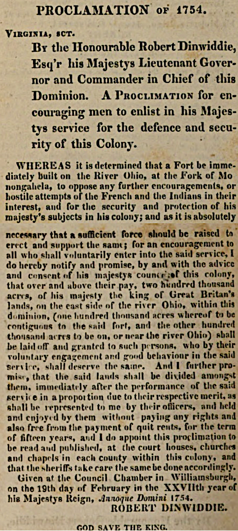
to recruit soldiers in 1754, Governor Dinwiddie promised free land plus a 15-year exemption from quit rents (property taxes
Source: William Waller Hening, The statutes at large
For the bounties to be valid, the British needed to expel the French from the Ohio River valley. Officials in Montreal, Quebec, and Paris expected that claims to land west of the Appalachians would be awarded in the name of the King of France. If the French established permanent military bases on the Ohio River, the Ohio Company would not be able to survey and sell 500,000 acres in the Ohio River Valley. Its 1748 land grant, which King George II had affirmed in 1751, would not be honored in Paris or Quebec.
Governor Dinwiddie appointed Joshua Fry as Colonel of the provincial force, with George Washington as Lieutenant Colonel. Colonel Fry died before the first components of the military force left Alexandria, so George Washington took charge.
Governor Dinwiddie's land bounty incentive was needed to recruit 300 volunteers for the Virginia "provincial" forces, but Washington had great difficulty gathering enough from the western counties. In 1754, he was just a 22-year old man from far away on the other side of the Blue Ridge. He lacked a reputation, and he laced the family connections needed to attract many followers from Frederick County. About 20 years later, Washington discovered again that recruiting soldiers to fight in the American Revolution was as difficult as recruiting soldiers for the French and Indian War.
In theory, every male Virginian over the age of 18 was prepared to fight as a member of the colonial militia. There was no process to "enlist" in order to join the militia organized in each county. According to colonial law, once a white male turned 18 he was automatically in the militia and responsible for having a musket or rifle.
The requirement to serve was mostly ignored during times of peace east of the Blue Ridge, where threats from Native Americans were minimial. Militia gatherings in Tidewater and the Piedmont were at times just social events.
That changed with the outbreak of the French and Indian War. According to a law passed in 1757, the militia obligation lasted until a man turned 50 years old. In every Virginia county, there were supposed to be companies of 32-68 men who assembled in their district for monthly militia training except in January and February. All companies were supposed to gather together in a general muster twice a year. In the 1750's, county leaders in the sparsely-settled western part of Virginia had not had time to create well-organized, well-trained militia companies.
Men who were supposed to be carving out time for monthly militia duty were busy starting farms on the edge of European settlement. Cutting down trees, clearing fields, planting crops, and building structures in the wilderness required all of their available time.
Many living on scattered farms in the backcountry, particularly in Augusta County and the Augusta District, failed to appear at the required times for militia training. In theory, they could be fined by the officers who assembled for a court martial hearing. In reality, the captains and County Lieutenant lacked the capacity to force men to show up.
The greatest threat to the settlers after the 1744 Treaty of Lancaster came from Shawnee and Delaware hunting and war parties. Families prepared to defend their individual homes against raids, creating fortified houses that could protect against a one-day attack. There was little desire to invest the extra time required to train with others and create an effective local militia unit that could go on offense, or march away from home to defend another area.
Colonels in charge of the county militia technically had the power to draft men of military age to serve in Dinwiddie's expeditionary force, but drafting men was a last resort. Land bounties were used to recruit volunteers, often landless laborers, who were willing to march away from home and fight in another area. It was politically unrealistic to try to force men to leave their farms in 1754, when France and Great Britain were officially at peace and there was no active war underway with Native Americans.
Some county officials proposed releasing men from the local jail to serve under Fry and Washington. Washington expressed his frustration with his recruitment efforts in a letter to his brother, saying:17
"Washington and the French & Indian War," Mount Vernon, https://www.mountvernon.org/george-washington/french-indian-war/washington-and-the-french-indian-war; "An act for regulating and disciplining the Militia (May 5, 1777)," Encyclopedia Virginia, https://encyclopediavirginia.org/primary-documents/an-act-for-regulating-and-disciplining-the-militia-may-5-1777/; "Robert Dinwiddie to George Washington, January 1754," Founders Online, National Archives, https://founders.archives.gov/documents/Washington/02-01-02-0031 (last checked December 30, 2025)
Before Washington's provincial force could come near the Monongahela River, the French sent troops from Fort LeBoeuf down the Allegheny River. They displaced the Ohio Company's construction team and started to construct Fort Dusquesne. Washington ended up ambushing a French detachment while it was asleep, then retreated to escape the French response. He was too slow to get away. He built Fort Necessity for defense, then had to surrender it in 1754.
Following that defeat, the General Assembly sought to recruit soldiers into a special colonial unit, a provincial army in which the soldiers would be paid. The October, 1774 "Act for raising levies and recruits to serve in the present expedition against the French, on the Ohio" included a provision to protect families of soldiers who might not be able to return to farming:18
"An Act for raising levies and recruits to serve in the present expedition against the French, on the Ohio (October 1754)," Encyclopedia Virginia, https://encyclopediavirginia.org/primary-documents/an-act-for-raising-levies-and-recruits-to-serve-in-the-present-expedition-against-the-french-on-the-ohio-october-1754/ (last checked December 12, 2025)
By 1756 the backwoods skirmish had erupted into the Seven Years War, known as the French and Indian War in North America. A land bounty originally expected to be claimed by just a few soldiers led by Fry/Washington ended up being a key recruitment tool for many Virginia troops for nine years.
In 1763, the war ended with the French ceding all claims to New France and surrendering their forts stretching to the Mississippi River. The British obtained legal ownership (by European standards) of Canada and the Ohio River and Mississippi River watersheds. For the first time, France accepted boundaries that were consistent with Virginia's claims under the 1609 charter. Peace with France created the potential for the Ohio Company to survey and sell parcels, and for veterans to claim their Ohio River land bounties.

the statue to the First Virginia Regiment in Richmond was removed, along with all Confederate monuments on city land, in 2020
Source: Wikipedia, Virginia Regiment
Peace with the Native American tribes took longer to achieve and delayed colonial officials in Williamsburg from processing the land bounties promised by Governor Dinwiddie. After the outbreak of Pontiac's War in 1763, King George III issued the Proclamation of 1763 that prohibited colonists from settling west of the Appalachian Mountains. In theory, keeping colonists and Native Americans separate would reduce the need to pay for an expensive set of forts staffed by Regulars.
The proclamation blocked colonial governors from issuing patents for settlers or land speculators to acquire legal title to land in the Mississpi River Watershed. At the same time, it included provisions for veterans of the French and Indian War to qualify for land grants.
Any Virginians who had joined Washington's expedition that ended in surrender at Fort Necessity, and also enlisted afterwards to fight in the Virginia Regiment, qualified for two grants. Such veterans could claim land under Governor Dinwiddie's offer, within the 200,000 acres he had set aside, plus at least 50 acres from King George III - once the king opened western lands to settlement. Those who began to serve after the surrender at Great Meadows were entitled just to the grant awarded by King George III.
By the time King George III issued his Proclamation of 1763 offering land as a reward for having fought during the French and Indian War in a provincial force such as the Virginia Regiment, a family could make a fair living on 100 acres. The king promised a grant that would be large enough to get all soldiers at least halfway there:19
"The Royal Proclamation - October 7, 1763 ," The Avalon Project, Yale Law School, https://avalon.law.yale.edu/18th_century/proc1763.asp; "Petition to Botetourt, 15 December 1769," Founders Online, National Archives, https://founders.archives.gov/documents/Washington/02-08-02-0189; Gabriel Neville, "The New Dominion: Virginia's Bounty Land," Journal of the American Revolution, December 4, 2025, https://allthingsliberty.com/2025/12/the-new-dominion-virginias-bounty-land/ (last checked December 31, 2025)
The process for claiming bounty land started with French and Indian War veterans submitting discarge documents or affadavits from commanding officers and felow soldiers to the governor's office. Once that office determined that the soldier had served for the required amount of time in a Virginia military unit (other than the militia), it provided a military certificate.
The soldier used that certificate to obtain a warrant, a piece of paper from the Land Office managed by the Secretary of the colony in Williamsburg. The warrant proved the soldier was qualified for a land grant. The warrant could then be sold by the veteran to a land speculator, or used to authorize a surveyor to mark the boundaries of a parcel of land.
Warrants were granted for parcels of different sizes based on military rank. King George III specified in the Proclamation of 1763 that common soldiers who had enlisted in provincial forces were entitled to land, but those who served just in the county militia were not entitled to acreage.
Surveyors were supposed to mark the boundaries of each parcel to include the acreage identified in individual warrants. To ensure satisfied customers and avoid a later lawsuit, surveyors often were generous in the acreage they included. The surveyor's documentation was presented to the Secretary of the colony, who then issued a patent (also known as a grant). The patent served as the legal deed to the property, and begins the chain of title for properties that stretches to the current day.
Before the American Revolution, surveyors could mark trees and define boundaries on any unclaimed land. Much of the land just west of the Blue Ridge was unsettled, but little of it was unclaimed.
To find large parcels of unclaimed land that could be divided into separate parcels, surveyors would journey westward into the hunting grounds of the Shawnee, Delaware, and Cherokee. All the food, gunpowder, and surveying equipment was carried on pack horses for a trip lasting several months. Surveyors would complete metes and bounds surveys, chopping boundary markers on trees. They would return with logbooks and sketches, then complete a formal survey document suitable for admission to colonial officials. Wealthy investors such as George Washington would finance the expeditions after accumulating enough warrants to justify the expense.
When a survey was submitted for final approval, anyone with a rival claim could challenge it by entering a "caveat." That blocked the award of land until conflicting claims could be resolved. The further west a surveyor traveled, the lower the chance that anyone would object.
One land speculator with extensive personal experience identifying valuable land in the backcountry was George Washington. As a teenager, he had started to survey parcels west of the Blue Ridge. In 1770, over twenty years later, he was still personally traveling in the Kanawha River valley with William Crawford to select the best parcels for his personal claims.
Washington sent directions to Crawford starting in 1767. The surveyor was supposed to seek out only the best possible land:19
"George Washington to William Crawford, 17 September 1767," Founders Online, National Archives, https://founders.archives.gov/documents/Washington/02-08-02-0020; "Washington as Land Speculator," Library of Congress, https://www.loc.gov/collections/george-washington-papers/articles-and-essays/george-washington-survey-and-mapmaker/washington-as-land-speculator/#N_12_; "Revolutionary War Bounty Land Claims," Library of Virginia, https://lva-virginia.libguides.com/bounty-claims (last checked December 31, 2025)
Crawford informed Washington in 1769 that, when he returned from a trip to Frederick, he discovered:19
"William Crawford to George Washington, 7 January 1769," Founders Online, National Archives, https://founders.archives.gov/documents/Washington/02-08-02-0120 (last checked December 29, 2025)
For French and Indian War veterans, the Proclamation of 1763 and also confusion about the western boundary of Pennsylvania prevented surveyors from getting official approval in the 1760's to carve out parcels. Speculators funded some surveys anyway, but few colonial officials accepted them in the 1760's.
Veterans and land speculators who purchased their rights discovered the Proclamation of 1763, confusion over the Virginia-Pennsylvania boundary, and duplicate promises of land grants to speculators delayed surrveying and patenting.
Virginia's wealthy elite, many of whom were descendants of political refugees who arrived during the English Civil War between 1642-1660, always assumed the Proclamation Line would be only temporary and that the Pennsylvania-Virginia border would eventually be defined. However, the delay in making land available to veterans caused many soldiers to sell their warrants to land speculators like George Washington. The wealthy could afford to pay immediately, and were willing to accept long delays in hopes of a significant profit later when a patent was finally issued. Reflecting that risk, the price paid to veterans for their warrants (the starting point for surveys and then patents) was steeply discounted.
Squatters took advantage of the delays. Without any payment or permission, they occupied river terraces in the Ohio River watershed where the soils were best suited for growing crops. Squatters anticipated that they would have strength in numbers.
The colonial Land Office in Williamsburg closed at the start of the American Revolution. The General Assembly re-opened it in 1779 and allowed a significant number of established (squatting) residents to acquire their parcels by preemption rights. Forcing families off "their" land in the middle of a war would have been bad public policy, and many squatters successfully gambled that posession would lead to legal ownership.
As a major land speculator, George Washington had constant problems with squatters. In 1770, he identified a valuable parcel on the Ohio River that offered a base for operations between Pittsburgh and the lands he owned on the Kanawha River. William Crawford surveyed the property in 1771 and determined the Round Bottom parcel encompassed 587 acres.
The official survey by William Crawford established Washington's primacy for ownership. Still, two other people tried to claim that land by 1773. Washington convinced one to leave. The other, Michael Cresap, built houses on it and started farming the land.
Cresap died in 1775. In 1784 the Virginia Land Office issued a patent to Washington for the Round Bottom property. Cresap's heirs then sought to obtain their own patent, and Washington had to enter a caveat objecting to their claim. He sold Round Bottom in 1798, a year before dying at Mount Vernon. The legal ownership of Round Bottom remained in question until Washington's buyer finally got clear title in 1834.19
"George Washington to Thomas Lewis, 1 February 1784," Founders Online, National Archives, https://founders.archives.gov/documents/Washington/04-01-02-0067; "George Washington to John Marshall, 17 March 1789," Founders Online, National Archives, https://founders.archives.gov/documents/Washington/05-01-02-0309 (last checked March 19, 2026)
As the commander of the 300-man force sent to the Ohio River in 1754, George Washington was entitled to the largest land bounty under Governor Dinwiddie's promise of 200,000 acres. As commander of the Virginia Regiment, he also qualified for 5,000 additional acres from King George III's promise. By purchasing warrants of other French and Indian War veterans, he ended up being entitled to the most acreage from service in that war. That land could be patented only after survey, so getting Lord Botetourt to authorize William Crawford's surveys was essential.
Washington could afford to make risky investments in land that might not produce income for many years, while most veterans desired a quicker reward for their service. Washington invested some of his wealth to buy the land claims of many veterans who did not want to wait for the British and colonial governments to sort out how to make good on the promised bounties. He spent time with the royal governors, particularly Botetourt and Dunmore. In an era where public officials often made decisons based on their private interests, a personal relationship could lead to personal favors regarding Washington's efforts to acquire land.
After the 1768 Treaty of Fort Stanwix, the 1768 Treaty of Hard Labor, and the 1770 Treaty of Lochaber eliminated the claims of the Iroquois and Cherokee, Washington tried to use his personal relationship with the royal governor of Virginia to get permission to survey and patent lands in the Ohio River watershed.
In 1769, Washington succeeded in getting Lord Botetourt and the Governor's Council to approve surveying the 200,000 acres promised to those who had served in the military force that ended up surrendering at Fort Necessity in 1754. The authorization was finalized on December 15, 1769. The colonial officials authorized up to 20 surveys along the Kanawha River.
At an August 2, 1770 meeting in Fredericksburg, other investors who had acquired large numbers of military warrants agreed to finance the surveys required to define parcel boundaries and obtain land deeds (patents). That decision was reaffirmed at a 1771 meeting in Winchester. Not all who were entitled to Governor Dinwiddie's land bounty provided funding for the surveys, creating frustration among the others who did fund the speculative investment.
To avoid conflict with various land company grants, existing settlers, Pennsylvania officials, and other land speculators actively claiming land near the Forks of the Ohio, those seeeking to claim the 200,000 acres promised by Governor Dinwiddie chose to focus on acquiring land farther west in the Kanawha River valley rather than at the Forks of the Ohio.
In October 1770, Washington personally started surveying parcels along the Kanawha River. That area might was within the boundaries of the Ohio Company's 1749 land grant, but he was closely associated with members of that company and could finesse any objections they might raise.
Washington's friend and physician, Dr. James Craik, plus the surveyor George Crawford accompanied Washington to what is now the middle of West Virginia. The Governor's Council had authorized the College of William and Mary to choose an official surveyor to mark boundaries for parcels within Governor's Dinwiddie's promise of 200,000 acres in 1754. Washington arranged for the selection of Crawford, who had already been hired to do surveying for Washington.19
"George Washington to Botetourt, 8 December 1769," Founders Online, National Archives, https://founders.archives.gov/documents/Washington/02-08-02-0188; "George Washington to Botetourt, 5 October 1770," Founders Online, National Archives, https://founders.archives.gov/documents/Washington/02-08-02-0261; "Petition to Botetourt, 15 December 1769,," Founders Online>, National Archives, https://founders.archives.gov/documents/Washington/02-08-02-0189; "George Washington to Charles Mynn Thruston, 12 March 1773," Founders Online, National Archives, https://founders.archives.gov/documents/Washington/02-09-02-0147; "George Washington to Lord Dunmore, 3 April 1775," Founders Online,, National Archives,, https://founders.archives.gov/documents/Washington/02-10-02-0247 (last checked March 19, 2026)
Washington raced out west after the 1770 Fredericksburg meeting to identify the best parcels for himself. In the mountains of western Virginia, flat acres on bottomland with springs that could water corn, wheat, and other crops were far more valuable than acres on steep mountain slopes that were suitable for just grazing cattle and hogs.
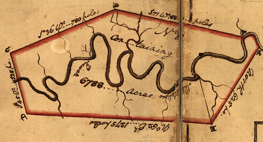
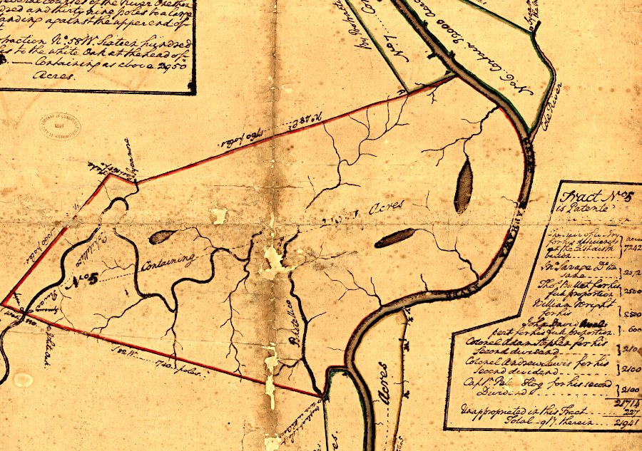
Washington selected tracts that were flat and watered by streams or springs; "bottomlands" had better soils for growing crops than hillsides
Source: Library of Congress, Eight survey tracts along the Kanawha River, W.Va. showing land granted to George Washington and others (1774)
Washington later declared that his lands surveyed along the Kanawha River were "...the cream of the Country in which they are: that they were the first choice of it; and that the whole is on the margin of the Rivers..."19
"George Washington to Presley Nevill, 16 June 1794," Founders Online, National Archives, https://founders.archives.gov/documents/Washington/05-16-02-0192 (last checked December 30, 2025)
On November 23, 1772 the field officers from the 1754 expedition met in Fredericksburg again to allocate among the claimants the 127,899 acres identified in the first 13 surveys along the Ohio and Kanawha rivers. The officers also allocated costs for reimbursing Washington for funding the surveys. He said he was willing to allow a revision of the parcels he would receive if anyone objected, but the officers determined that "there is no great inequality in the Land which is already Surveyed."19
"Resolutions of the Officers of the Virginia Regiment of 1754, 23 November 1772," Founders Online, National Archives, https://founders.archives.gov/documents/Washington/02-09-02-0091 (last checked December 30, 2025)
Washington provided a very different description in 1772, when a veteran who had not funded the surveys questioned how the parcels were allocated:19
"George Washington to Charles Mynn Thruston, 12 March 1773," Founders Online, National Archives, https://founders.archives.gov/documents/Washington/02-09-02-0147 (last checked December 30, 2025)
The Governor's Council approved a second allotment of land under the Proclamation of 1754 on November 4, 1773. The last five certificates covered 72,299 acres of land. The process of distributing the 200,000 acres promised by Governor Dinwiddie involved wealthy investors paying for surveys of large tracts. Men with claims based on service in the French and Indian War, or who had purchased the warrants from such veterans, were allocated a certain number of acres within each tract defined by a large survey. There were 60 soldiers entitled to a part of one tract which included 28,627 acres.
Getting the surveys authorized was the first step in transferring land into private ownership. Getting the acres allocated was the second step, finally accomplished in 1773. In a third step, additional surveys were required to mark the boundaries of separate parcels for each person within each of the surveys, based on the acres to which each individual was entitled. The last step was for the Secretary of the colony to issue a patent (deed) signed by the governor, transferring title.
When George Washington reported that the last allocation of the 200,000 acres within the large initial surveys, he noted his frustration that some veterans had not advanced any money to fund those initial surveys and he was expected to pay the surveyor:19
"George Washington to Lord Dunmore and Council, 3 November 1773," Founders Online, National Archives, https://founders.archives.gov/documents/Washington/02-09-02-0283 (last checked December 30, 2025)
In 1775, British officials in London declared that the surveys of the 200,000 acres were invalid. That decision radicalized Virginia's elite even further, since they viewed it as harsh economic retribution for their political advocacy to change Parliament's policies. George Washington initially though the report was "altogether incredible, then wrote to Governor Dunmore on April 3, 1775 and asked him to intervene. Washington emphasized:19
"George Washington to Lord Dunmore, 3 April 1775," Founders Online, National Archives, https://founders.archives.gov/documents/Washington/02-10-02-0247 (last checked March 20, 2026)
Dunmore decided he had to support the policies determined in London. He was already planning to seize the gunpowder stored in the magazine in Williamsburg, complying with orders sent to all colonial governors in an effort to prevent insurrectionists from getting armed. Governor Dunmore wrote a terse rejection to Washington on April 18::19
"Lord Dunmore to George Washington, 18 April 1775," Founders Online, National Archives, https://founders.archives.gov/documents/Washington/02-10-02-0262 (last checked March 20, 2026)
Land speculators included Virginia's wealth elite and its appointed royal governors. After Governor Botetourt died, Lord Dunmore transferred from New York to Virginia in 1771. Dunmore was a land speculator when he was royal governor of New York. THere he sought grants of unsettled lands far east of the Proclamation of 1763 line. In his new colony, Dunmore again sought to gain personal wealth by acquiring land in Virginia, but the unsettled land was west of the Proclamation Line.
The 1768 Treaty of Fort Stanwix and the 1770 Treaty of Lochaber had resolved (at least to the English) the Iroquois and Cherokee claims to territory south of the Ohio River. However, after the treaties were ratified in London, royal officials did not issue instructions allowing colonial governors to issue patents west of the Appalachians.
Land speculators who had purchased warrants from French and Indian War veterans, in anticipation that the royal constraints would be lifted, pressed to have surveys authorized. George Washington sought to get surveys approved for the 5,000 acres to which he was entitled as commander of the Virginia Regiment, plus another 8,000 acres he could patent after purchasing warrants issued to others who had served between 1754-1758.
19
"George Washington to William Preston, 28 February 1774," Founders Online, National Archives, https://founders.archives.gov/documents/Washington/02-09-02-0374) (last checked February 16, 2026)
Defining parcels would allow speculators to allocate land among themselves. Surveyed but still-unpatented claims had significant value in an economy where cash was scarce, and approval of surveys was expected to be followed by approval of patents.
Dunmore made a few exceptions to the prohibition of authorizing land transfers west of the 1763 Proclamation Line, but most of the time he refused to allow official surveys. Despite that constraint, the speculators funded survey expeditions that would establish prior rights to parcels, once British officials allowed conversion on land west of the Alleghenies into private ownership.
Different groups of speculators were in competition. In 1773 William Bullitt, associated with the Ohio Company and an ally of George Washington, led an expedition that surveyed lands in Kentucky. The Fincastle County surveyor, William Preston, refused to authorize Bulltt's surveys because no Fincastle County surveyor had participated, and at the time Kentucky was part of Fincastle County.
Preston was allied with the Loyal Land Company and the Greenbrier Company. Speculators in those land companies wanted to patent the best lands in Kentucky before allowing competing land companies to file claims.
Governor Dunmore visited Fort Pitt in the summer of 1763, where he made arrangemebnts with Dr. John Connolly to acquire western lands. Dunmore promised Connolly 2,000 acres at the Falls of the Ohio River, now Louisville, Kentucky. Dunmore and his Governor's Council heard an appeal from William Bullitt on December 15, 1773.
The Loyal Land Company and the Greenbrier Company were disappointed by the decision announced the next day, December 16. The governor allowed all officers to claim the 1,000 acres to which they were entitled under the Proclamation of 1763 "wherever they should desire," so long as a previous survey was not affected.
Governor Dunmore also fulfilled a promise and issued a patent to Dr. Connolly for his 2,000 acre tract, which William Bullitt had surveyed. Preston refused to accept Bullitt's 1773 surveys, but was willing to resurvey the lands. In 1774 he sent his deputy John Floyd on an expedition to complete surveys along the Kentucky River and near the Falls of the Ohio.
Settlers were already crowding into the region, not waiting for the legal process to acquire land. Daniel Boone had tried to lead a party from the Poweels River Valley through the Cumberland Gap in 1773. His son was killed on that trip and the group turned back, but Boone returned to Kentucky in 1774. James Harrod, who had explored central Kentucky in 1773, led a different group of settlers down the Ohio River in 1774 and established Harrodsburg on the Kentucky River.
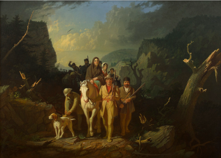
Daniel Boone led settlers into Kentucky in 1774 despite the ban on surveying/patenting land in the Proclamation of 1763
Source: Kemper Art Museum, Daniel Boone Escorting Settlers through the Cumberland Gap (George Caleb Bingham, 1851-52)
Floyd led his men on foot down the New River to its confluence with the Gauley River. After passing Kanawha Falls, the 16 men made canoes and floated down the Kanawha River. They surveyed some parcels as they went. Shawnee resistance to their presence was clear, and William Preston sent messengers to recall the surveyors. Daniel Boone traveled extensively throughout Kentucky to warn all surveyors and settlers as Dunmore's War broke out. Not all managed to flee Kentucky alive, but the land hunger remained strong and Harrodsburg was reoccupied in 1775.
19
"Fincastle County Surveys," Early Kentucky Land Records, 1773-1780, Genealogy trails History Group, https://genealogytrails.com/vir/fincastle/fincastlesurveys.html; Gabriel Neville, "The New Dominion: Virginia's Bounty Land," Journal of the American Revolution, December 4, 2025, https://allthingsliberty.com/2025/12/the-new-dominion-virginias-bounty-land/; Robert F. Collins, "A History of the Daniel Boone National Forest, 1770-1970," 1976, pp.33-38, https://www.google.com/books/edition/A_History_of_the_Daniel_Boone_National_F/2eoTAAAAYAAJ (last checked February 17, 2026)
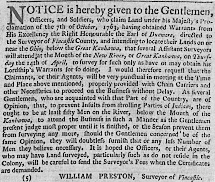
in 1774, William Preston advertised in Williamsburg that he planned to survey parcels located west of the 1763 Proclamation Line
Source: Virginia Chronicle, Virginia Gazette (February 24, 1774, p.3)
The colonists expected that those surveys, approved by Preston, would be processed by the Land Office and patents would be issued. On December 16, 1774 Governor Dunmore appeared to be willing to allow processing of the necessary paperwork to patent lands in the Ohio River watershed despite offical instructions. Part of his motivation was that surveyors from Pennsylvania were marking boundaries of parcels in the Ohio River Valley, and Virginia was at risk of losing its claim to western lands.
Everyone's expectations were overcome by events, Dunmore's War in 1774 and then the American Revolution. When the royal governor fled Williamsburg in June, 1775, the process for approving surveys and issuing patents to French and Indian War veterans stopped.19
"George Washington to Lord Dunmore, 2 November 1773," Founders Online, National Archives, https://founders.archives.gov/documents/Washington/02-09-02-0282 (last checked December 30, 2025)
A restart occurred in 1779. The General Assembly passed a land law on May 3, 1779 to create a Land Office that could process land bounties awarded to soldiers who enlisted in the state forces or Continental Army. The land law also made it possible for holders of warrants and surveys issued while Virginia was still a colony to obtain a deed, and for the new state to sell land for cash:19
William Waller Hening (editor), "An act for establishing a Land office, and ascertaining the terms and manner of granting waste and unappropriated lands," The Statutes at Large, Being a Collection of All the Laws of Virginia, 1822, pp.50-65, https://jeffersonswest.unl.edu/archive/view_doc_jef.00060.html (last checked December 31, 2025)
The Virginia government seized land owned by loyalists during the American Revolution. It was sold by the Register of the Land Office, with revenue used to pay off the loyalist's debts. Any remaining value was kept by the state government. The colony and then the state still re-acquires a small amount of property through escheat, when a landowner died without heirs. The responsibility for disposing of escheated assets was transferred to the Secretary of the Commonwealth in 1924 when the Land Office was abolished. In 1952, the state librarian was given responsibility for issuing the grant for escheated land.19
"The Virginia Land Office," Research Notes Number 10, Library of Virginia, February 2010, https://old.lva.virginia.gov/public/guides/Research_Notes_20.pdf (last checked December 31, 2025)
On June 22, 1779, over three years after declaring independence from Great Britain, the General Assembly authorized giving away parcels of land to attract volunteers to serve during the Revolutionary War. All lands within the state could be claimed.
To qualify for a land bounty, a soldier had to shift from short-term involuntary militia duty and commit to serving for three continuous years in the State Line (within Virginia) or Continental Line (which served primarily in other states, until the 1781 Yorktown campaign). Men could also serve as sailors in the State Navy. For many families, the continuous commitment took a key worker away from the farm for three harvest seasons.
By the end of the American Revolution, soldiers and sailors who enlisted from Virginia were entitled to 100 acres if they had served for three years and an additional 100 acres if they committed to serve to the end of the war. Noncommissioned officers were entitled to twice that amount.
Officers below the level of general were awarded between 2,000-6,000 acres plus an additiional 1/3 bonus. Brigadier Generals were granted 10,000 acres and Major Generals were given 15,000 acres.
After the military service was completed, veterans obtained certificates that they had served a sufficient time in a Virginia unit. Affidavits from officers testifying that a person qualified for the bonus were submitted to the governor. As described by the Library of Virginia:20
"Revolutionary War Rejected Claims for Bounty Land," Library of Virginia, http://www.lva.virginia.gov/public/guides/opac/rejectedabout.htm (last checked April 6, 2018)
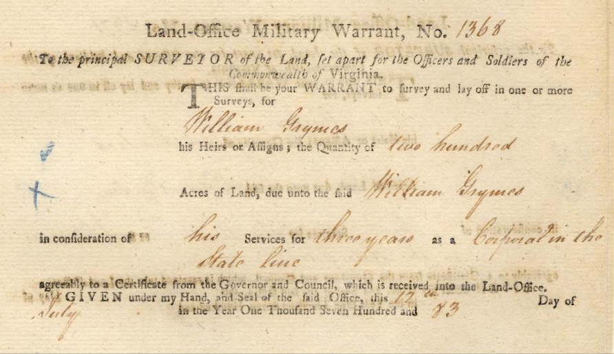
William Grymes earned 200 acres from his Revolutionary War military service as a corporal in the State Line
Source: Kentucky Secretary of State, Revolutionary War Warrant 1368.0
Between July 14, 1782 - August 5, 1876, the office of the governor issued 9,926 certificates to authorize Revolutionary War veterans or their heirs to claim land based on military service. Major Generals were entitled to 15,000 acres, and for large bounties multiple warrants might cite the same certificate for proof of service.
Heirs were entitled to land if their ancestor died while serving as a soldier or sailor in the military, prior to completing three continuous years of service. Descendants claiming their ancestor was entitled to a land bounty had to prove 1) the ancestor met the qualifications and 2) they were the legal heirs entitled to exercise the military warrant.
Many soldiers sold their military warrants for quick cash, soon after getting the documents. Land speculators with capital to invest, including George Washington, purchased many of the military warrants at a discount. Years later, the speculators used them to acquire tracts and then sell the land for a profit.
The Kentucky Secretary of State "Frequently Asked Questions" page explains how military warrants were converted into land. The process for the Revolutionary War warrants also applied to warrants issued for Lord Dunmore's War in 1774 and the earlier French and Indian War.21
"FAQs," Kentucky Secretary of State, https://www.sos.ky.gov/admin/land/military/Pages/FAQs.aspx; "Revolutionary War Bounty Land Claims," Library of Virginia, /a> (last checked December 12, 2025)
In 1830, the US Congress passed the Scrip Act. By then, almost all claims were filed by descendants. The law allowed state warrants to be used to purchase Federal land. At the time, such land was available in the Florida Territory, the Michigan Territory, the Arkansas Territory, and the unorganized Missouri Territory that composed the rest of the Louisiana Purchase. Starting in 1852, all Virginia claims based on Revolutionary War service had to be converted into scrip for acquisition of Federal lands.22 Moody Morse Peabody, "Map of the United States: compiled from the most authentic sources," Library of Congress, 1831, http://hdl.loc.gov/loc.gmd/g3700.ct003557; "Revolutionary War Bounty Land Claims," Library of Virginia, /a> (last checked December 12, 2025)

land grants were used to recruit soldiers and officers to serve during the French and Indian War
Source: Library of Congress, Three-thousand acre land grant to the heirs of Hugh Mercer, Kentucky County, Virginia
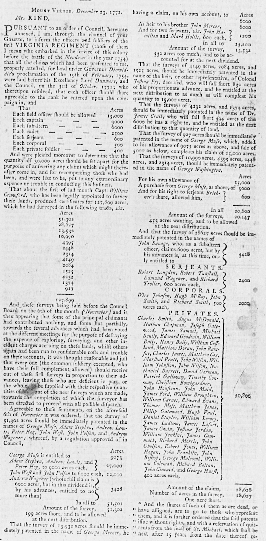
George Washington managed the surveys required for patenting parcels to veterans of the French and Indian War
Source: Virginia Chronicle, Virginia Gazette (January 14, 1773, pp.1-2)
indentured servants were still being imported just before the American Revolution
Source: Virginia Chronicle, Virginia Gazette (December 17, 1772, p.3)