Interstate 66 (I-66)
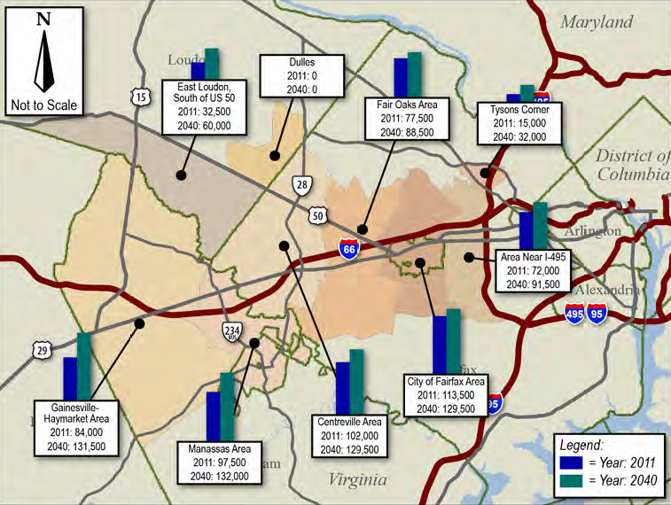
predicted population growth in western Prince William is expected to generate customers willing to pay for use of the HOT Lanes
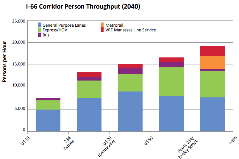
Source: Virginia Department of Transportation, Tier 1 Final Environmental Impact Statement and Tier 1 Record of Decision (Figure 2-5)
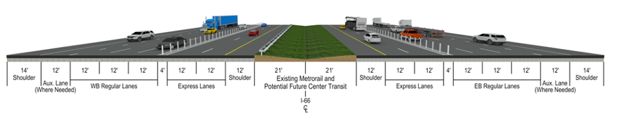
HOT Lanes construction will preserve a path for future Metrorail, except from Centreville to Manassas
Source: Virginia Department of Transportation, Transform I-66 Outside the Beltway, What will I-66 look like when the project is completed?
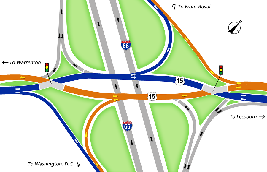
the Route 15 bridge over I-66 in Haymarket (Prince William County) was converted into a diverging diamond interchange in 2016
Source: Virginia Department of Transportation, I-66 and Route 15 Interchange Reconstruction
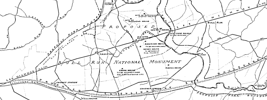
in 1935, planning for the future Manassas National Battlefield Park included the route of a new highway that is now I-66
Source: National Park Service, Preliminary Study for the Proposed Boundaries of Bull Run National Monument (1935)
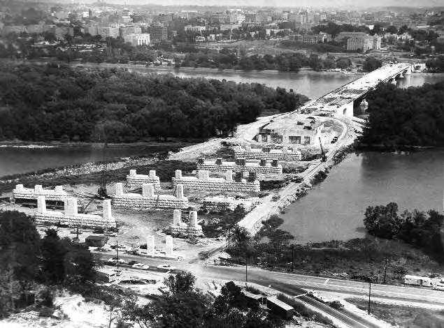
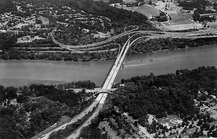
the Teddy Roosevelt Bridge (shown under construction) carries I-66 into Washington, DC
Source: US Army Corps of Engineers, Capital Engineers: The U.S. Army Corps of Engineers in the Development of Washington, D.C., 1790-2004 (p.249)
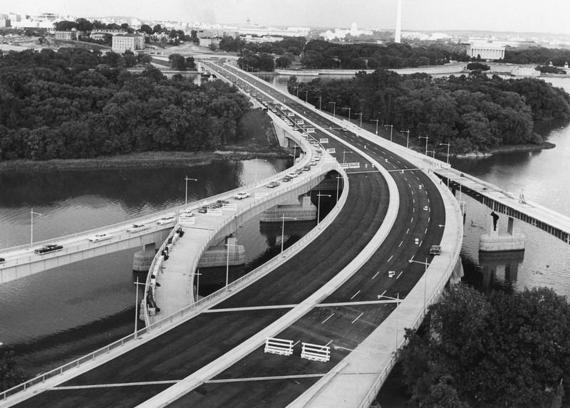
the Teddy Roosevelt Bridge, near completion
Source: District of Columbia Library, File #2535: "Theodore Roosevelt Bridge 008"
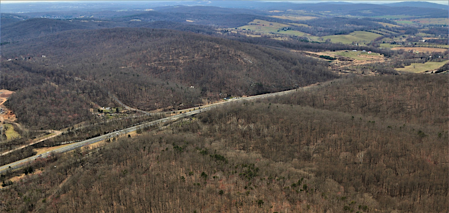
I-66 passing through Thoroughfare Gap, on border of Prince William and Fauquier counties
Source: Historic Prince William, Aerial Photo Survey 2019
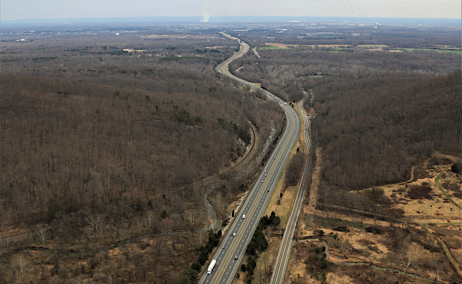
looking east into Prince William County, where I-66 passes through Thoroughfare Gap
Source: Historic Prince William, Aerial Photo Survey 2019
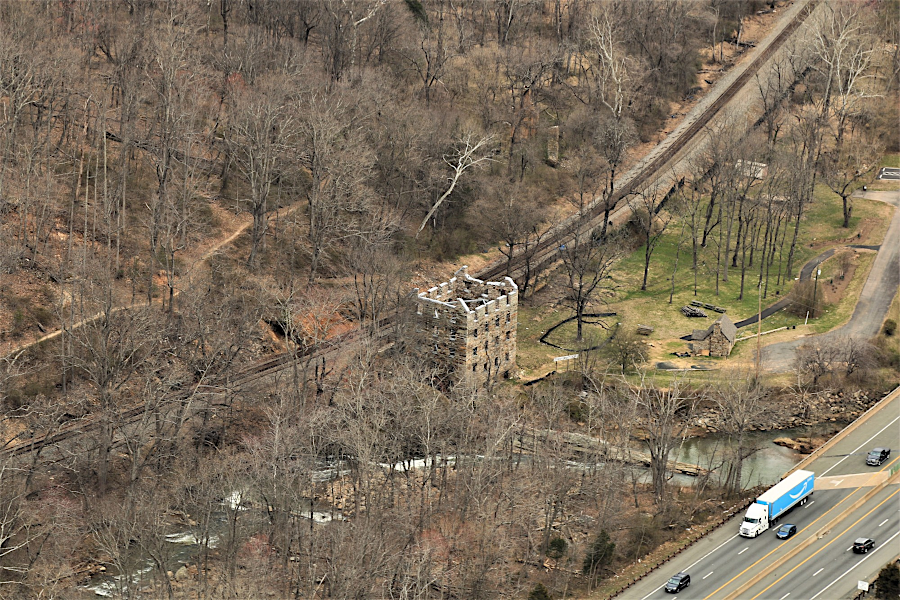
Chapman's Mill, visible from I-66 where it passes through Thoroughfare Gap
Source: Historic Prince William, Aerial Photo Survey 2019
Plans for I-66 through the District of Columbia included building a new six-lane bridge across the Potomac River at the Three Sisters islands. The three rocks were, according to local legend, the site where three Anacostian maidens drowned while trying to canoe across the river to meet their lovers from another Native American tribe.1
In Virginia, I-66 would split at Spout Run and trucks would be allowed to use the Three Sisters Bridge into the District. Only cars would be permitted to cross the Potomac River on the Teddy Roosevelt Bridge. Highway construction within the District would have included building a Potomac Freeway from the Three Sisters Bridge downstream to the existing Whitehurst Freeway, plus a new Glover-Archbold Parkway to carry traffic to the north.
In 1967, the Federal government reorganized local government for the District of Columbia. The new leaders reflected local opposition to construction of the major highways that would disrupt neighborhoods, and were consistently in favor of funding the proposed Metrorail subway system and opposed to building the Three Sisters Bridge. Powerful members of the US House of Representatives from Kentucky and Illinois forced the new city council to pursue construction anyway, despite a 1969 referendum when 85% of voters opposed the bridge.
In 1971, support piers for the bridge were built up to the surface of the Potomac River. However, construction stopped after the US Court of Appeals ruled that the Federal government had not followed its procedures for approving the project, and in 1972 the massive flooding after Hurricane Agnes removed the unfinished piers.2
how the Three Sisters Bridge would have looked
Source: District of Columbia Department of Transportation (D.Dot), Three Sisters Bridge
to move towards DC from Gainesville, there are alternatives to driving on I-66
Source: Virginia Railway Express (VRE), VRE Broad Run Expansion Project
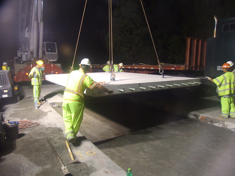
a 2009 repaving project used precast concrete slabs on a ramp lane leading to US-50 West
Source: Federal Highway Administration, Slab Positioned Into Place
a ramp lane leading to US-50 West
Links
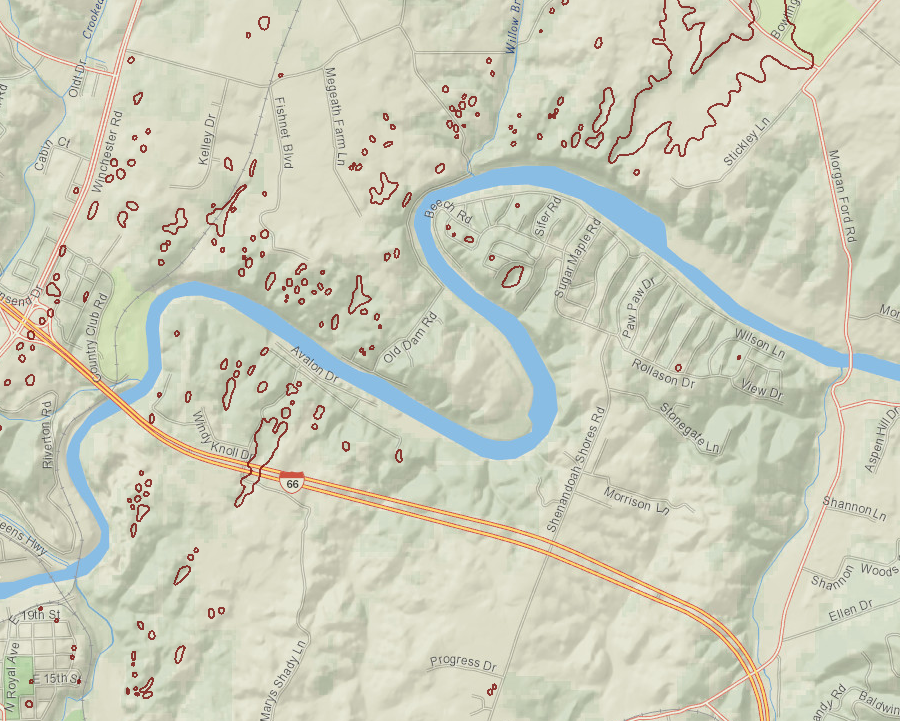
the western end of I-66 crosses karst topography with sinkholes in the Shenandoah Valley near Front Royal
Source: Virginia Department of Conservation and Recreation (DCR), Natural Heritage Data Explorer
References
1. "Why Is It Named The Three Sisters (Islands)?," Ghosts of DC blog, October 4, 2013, https://ghostsofdc.org/2013/10/04/named-three-sisters-islands/ (last checked August 4, 2019)
2. "Never Built Three Sisters Bridge Across The Potomac," Ghosts of DC blog, April 13, 2015, https://ghostsofdc.org/2015/04/13/never-built-three-sisters-bridge-across-potomac/ (last checked August 4, 2019)
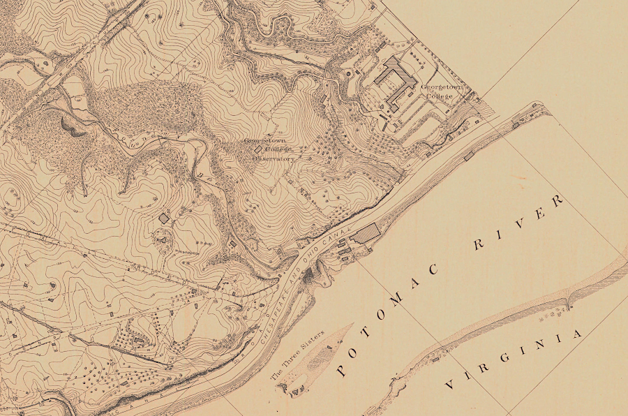
transportation planners proposed building I-66 into the District of Columbia, crossing the Potomac River at the islands known as the Three Sisters
Source: National Oceanic and Atmospheric Administration (NOAA), Topographical Survey of the District of Columbia
From Feet to Space: Transportation in Virginia
Virginia Places