How the Counties Were Named
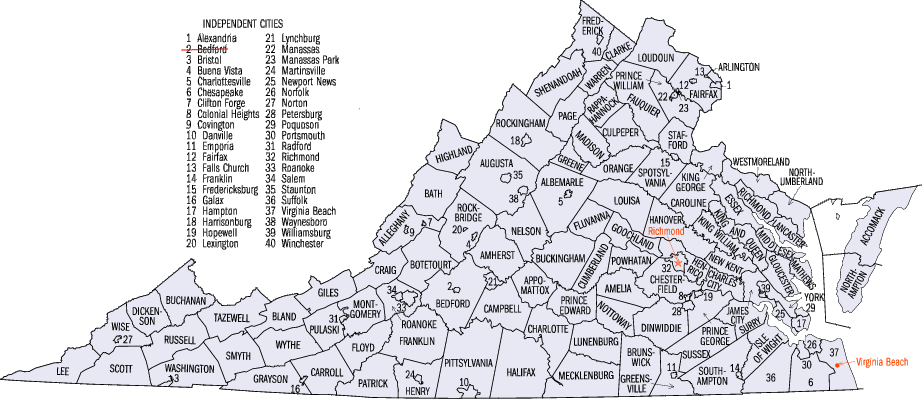
the names of most cities and counties in Virginia reflect the political conditions at the time; local jurisdictions created after 1775 do not honor English monarchs and their supporters
(Bedford is now a town, not an independent city)
Source:
Bureau of Census
The history of Virginia and the evolution of its local governments are reflected in place names.
One of the first decisions of the settlers who arrived in Jamestown in 1607 was to name the points of land at the entrance to the Chesapeake Bay, and the modern names still commemorate the two sons of King James. Native Americans who lived in the area had already named the major river after their paramount chief, but the English replaced "Powhatan" with the name of their own king.
The first Virginia settlement was also named after King James. The second settlement, Henricus, was given the name of the King's oldest son in 1612. The first General Assembly in 1619 requested the Virginia Company to change the "savage name of Kicowtan." Company officials in England chose to rename it after King James' daughter Elizabeth, and in 1634 the General Assembly designated the new local government in that area Elizabeth City County.1
Some Native American place names were retained. Words such as Chesapeake, Rappahannock, and Potomac were used long before the colonists arrived, and survive to this day.
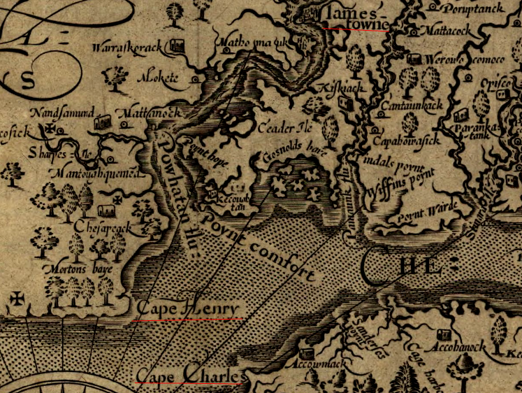
starting in 1607, colonists chose replacements for Native American names that honored major figures back in England, beginning with King James and his two sons Prince Henry and Prince Charles
Source: Library of Congress, Virginia (map by John Smith, 1624)
|
The names of local Native American towns were used for two of Virginia's first eight counties created in 1634. Accomac County is still on the map, but three years later Warrosquyoake County was renamed Isle of Wight County.
The General Assembly created new counties as the population increased and expanded away from the capital at Jamestown, Williamsburg, and ultimately Richmond. The names of those counties reflect the politics of the time.
In the colonial era, the legislature honored key English officials by naming counties after families or places associated with those officials. Frederick and Augusta counties, for example, were named after the oldest son of King George II and his wife. Prince William was named after a younger son of George II. Spotsylvania County was named after colonial governor Spotswood; Goochland County was named after Gov. Gooch, Dinwiddie County was named after Gov. Dinwiddie...
Pittsylvania County was created at a time when Virginia was frustrated with how Great Britain was governing the colonies. In Parliament, William Pitt was championing a different policy, and proposed granting more authority to the colonies. The names of the counties just to the west indicate that reconciliation failed. Those two counties were named after Patrick Henry.
At the time when population growth justified creation of new counties in the western Piedmont, Virginia stopped honoring the English and started honoring its home-grown rebels. Today, over 50% of counties still honor English officials or places associated with them.2
There's a story behind the name and the timing of the creation of each county that is now part of Virginia. Scott County is named for the leader of the Yankee military that invaded Virginia in 1861 - but Virginia no longer has any county named for Thomas Jefferson and George Mason. They ended up in Kentucky and West Virginia, when those portions of Virginia became separate states.
The county of Illinois disappeared after Virginia ceded the Northwest Territory to the Congress, initially as an incentive to get Maryland to sign the Articles of Confederation. Illinois County has since been carved up to create the tates of Ohio, Indiana, Illinois, Michigan, and Wisconsin.
Links
References
1. "Uncovering Traces of Historic Kecoughtan," Center for Archaeological Research, College of William and Mary, http://www.wm.edu/sites/wmcar/research/pentran/index.php (last checked January 9, 2016)
2. Charles M. Long, Virginia County Names, Neale Publishing Company, 1908, p.22
Counties in Virginia
Virginia Places