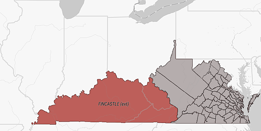
Fincastle County existed between December 1, 1772 - December 30, 1776
Source: Encyclopedia Virginia, Fincastle County 1772-1776
Fincastle County existed between December 1, 1772 - December 30, 1776
Source: Encyclopedia Virginia, Fincastle County 1772-1776
Fincastle County was created in 1772 from Botetourt County, whose boundaries extended all the way to the Mississippi River. Lord Botetourt was a very popular governor of the Virginia colony between 1768-1770. He died as the tensions between colonists and British officials were increasing and making the job much more difficult.
John Murray, the Earl of Dunmore and Viscount of Fincastle, succeeded Lord Botetourt. Fincastle County was named for his son Lord Fincastle.1
Fincastle County was created as population grew west of the Blue Ridge, primarily in the valleys of the Holston and New Rivers. Clinch River settlers were occupying land claimed by the Loyal Land Company based on its 1749 grant. Those settlers, such as Jacob Castle and others who arrived in 1769 at Castle's Woods (now Castlewood in Russell County), did not join in the petition to create the new county. That:2
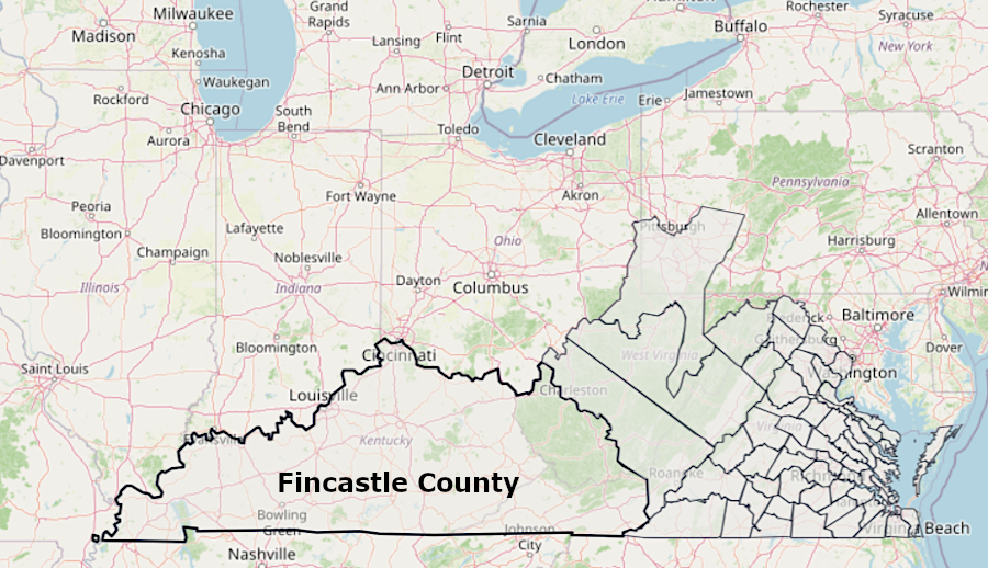
Fincastle County boundaries stretched to the Mississippi River
Source: Newberry Library, Atlas of Historical County Boundaries
Fincastle County was located west of the Proclamation of 1763 line which, in theory, limited settlement by Virginia colonists to the lands east of the Eastern Continental Divide. In the 1768 Treaty of Hard Labor and the 1770 Treaty of Lochaber, the Cherokee agreed to open much of the western lands. Those treaties allowed the General Assembly to create the new county in 1772 without drawing the ire of London officials.
After 1772, colonists coming down the Wilderness Road to settle on the western side of Pine Mountain, moving into the Kentucky River watershed in violation of the Proclamation of 1763, passed through Fincastle County. The last community those settlers passed through was Castle's Woods on the Clinch River, now the town of Castlewood in Russell County.
In 1773, William Russel and Daniel Boone were leading a group towards Cumberland Gap when the Shawnee attacked. The oldest sons on Russell and Boone were both among those who were killed. The two young men ended up being buried in the same grave.3
In 1774 the royal governor, Lord Dunmore, sought to gain support from the western colonists by fighting the Shawnee and pushing them north across the Ohio River. Militia from Fincastle County fought in Dunmore's War and helped win the key battle at Point Pleasant on October 10, 1774. That war ended with the Treaty of Camp Charlotte, in which the defeated Shawnee surrendered their claim to the territory south of the Ohio River.
While returning home after the treaty was negotiated, the militia gathered at Fort Gower on the Ohio River (now Hockingport, Ohio). At the time, the most western settlement in Virginia was in Fincastle County at Castle's Woods, 170 miles south and 35 miles further west of Fort Gower. Castle's Woods eventually evolved into Castlewood, now in Russell County.
The men at Fort Gower received news of the Continental Congress, which had met in Philadelphia and passed a nonimportation agreement. With the support of representatives appointed by the Virginia Convention, the colonies had united and agreed to a joint response to Parliament and King George III.
The militia officers on the Ohio River endorsed the actions of the Continental Congress and passed the Fort Gower Resolves on November 5, 1774. Those resolves boldly asserted the willingness of the backcountry leaders to fight if necessary to address the colonial grievances. The document expressed support for King George II, but also included the commitment to:4
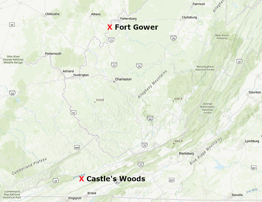
when the Fort Gower Resolutions were approved in 1774, what is now Castlewood in Russell County was the western-most settlement
Source: ESRI, ArcGIS Online
The lead deposit discovered by Colonel John Chiswell, which became a key source of lead needed for bullets in the American Revolution, was located in the new county. The justices of the peace, appointed by Governor Dunmore to form the first county court for Fincastle County, assembled at the lead mines on January 5, 1773.5
On January 20, 1775, leaders of Fincastle County assembled at McGavock's Tavern in Fort Chiswell, or perhaps at the courthouse near the lead mines, to endorse the nonimportation policy which had been adopted by the Continental Congress and the First Virginia Convention.
Nonimportation was designed to apply economic pressure on Great Britain, forcing it to reverse the Coercive Acts adopted after the Boston Tea Pary in 1773. Similar agreements to stop purchasing goods from Great Britain had been effective in getting Parliament to cancel the 1765 Stamp Tax and the 1766/1767 Townshend Acts, which tried to extract taxes from the North American colonies to help repay debts incurred in the French and Indian War.
The 15 "freeholders" who passed the Fincastle Resolutions sent them to Virginia's delegates at the Continental Congress, plus Purdie's Virginia Gazette for publication in Williamsburg. The leaders in the remote county must have recognized that stopping their purchases of imported goods would have no economic impact in London. There were few residents west of the New River; most purchases from Great Britain were made by planters in Tidewater Virginia.
However, the Fincastle Resolutions, like the Fort Gower Resolves, made clear that settlers in the backcountry were united with the rest of the colonists in challenging British authority. The Proclamation of 1763 and the inability to finalize surveys on land granted to Loyal Land Company constrained the ability to purchase land legally. Settlers in western counties feared their investment in carving farms out of the wilderness would be lost.
Fincastle County was one of the last in the colony to pass a resolution objecting to British policies and calling for action. The delay occurred because the local militia had marched north in Dunmore's War, eventually fighting at Point Pleasant. The resolutions from Augusta, Botetourt, and Pittsylvania counties were also late. They were more assertive regarding the threat of fighting, with the Fincastle Resolutions including:6
William Preston was chosen to be county surveyor when Fincastle County was established. In that role, Preston's approval was required before surveys done by others could be submitted to the colonial land office for processing. That enabled him to assist the Loyal Land Company, with which he was allied, by rejecting surveys conducted by rival land speculators.
Preston directed his deputy county surveyors from his plantation house, Smithfield, which he built between 1772-1774. Today Smithfield is adjacent to the Virginia Tech campus in Blacksburg.
With support from George Washington, Thomas Bullitt led a party into Kentucky in 1773 to survey parcels for patenting based on warrants issued to veterans of the French and Indian War. Preston rejected those surveys as unauthorized, but Bullitt and his backers soon convinced Governor Dunmore to overule the Fincastle County surveyor.
Preston then sent his own deputy county surveyors into Kentucky in April 1774. He hiring some men who had been part of Bullitt's party in 1773. The first "official" Fincastle County survey was completed along the Ohio River, opposite the mouth of Scioto River, by deputy county surveyor John Floyd on May 2, 1774.
Preston's men surveyed 145,000 acres until July, when Shawnee killed several men and forced the surveyors to flee. One group walked east, crossing the mountains to return to the New River. Another group floated down to New Orleans and caught a ship to get back to Virginia.7
Fincastle County was abolished in 1776 and divided into three new counties - Montgomery, Washington, and Kentucky (which later became the state of Kentucky). The decision to extinguish the name "Fincastle" rather than retain it for one of the new counties reflected the new status of the royal governor.
Lord Dunmore had led the military opposition to the "rebels" in Virginia in 1775-1776. He issued an emancipation proclamation in 1775 that offered to free enslaved men that were owned by the rebelling colonists and were willing to join the Ethiopian Regiment in his army. Dunmore's Proclamation was a turning point in forcing reluctant colonists to join the revolution, rather than accept a social and economic transformation which might threaten the institution of slavery.
For similar reason, "Dunmore County" was renamed "Shenandoah County."8
"Fincastle" remains on Virginia maps with the town of Fincastle. It has been the county seat of Botetourt County since 1772.9