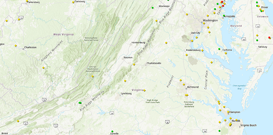
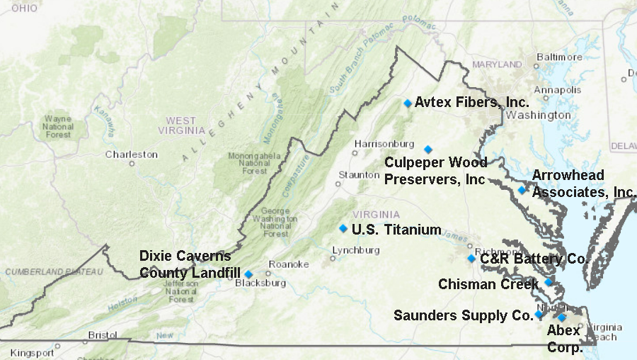
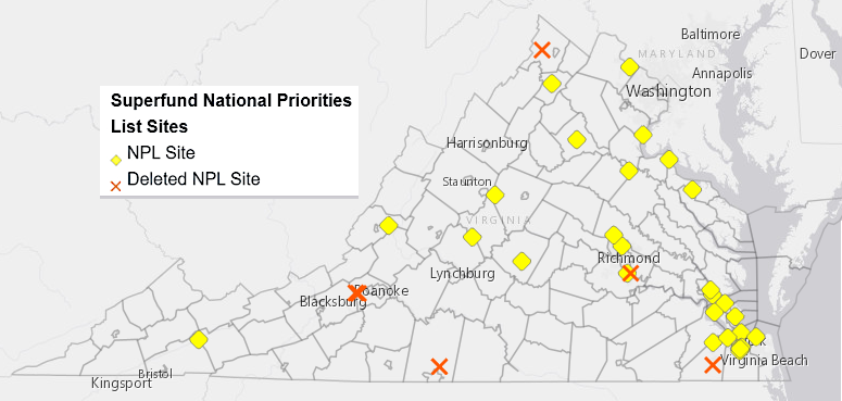
location of the 36 Superfund sites in Virginia in 2021
Source: Environmental Protection Agency Header Controller Superfund National Priorities List (NPL) Where You Live Map
location of the 36 Superfund sites in Virginia in 2021
Source: Environmental Protection Agency Header Controller
Superfund National Priorities List (NPL) Where You Live Map
The "Superfund" program to clean up the most-polluted sites in the United States began in 1980, when Congress passed the Comprehensive Environmental Response, Compensation, and Liability Act (CERCLA). Congress had increased Federal oversight of toxic materials with passage in 1976 of the Resource Conservation and Recovery Act (RCRA), which helped the states begin regulating the handling and disposal of hazardous wastes, and the Toxic Substances Control Act (TSCA), which helped to identify the sources of hazardous materials.
Public reaction was strong in 1978 to the discovery of the health impacts from municipal and industrial chemical wastes which had been dumped into Love Canal in New York. Pictures of waste-disposal drums rusting in the ground, and reports of illnesses and birth defects, caused President Carter to approve emergency financial aid. It was the first time disaster aid had been authorized for something other than a "natural" disaster.1
It was obvious that the costs of cleanup would be high. The owners of sites and operators of polluting facilities were considered to be Potentially Responsible Parties (PRP's), with a financial obligation to remove the risks of the hazardous materials. Recognizing that some landowners and polluting companies had gone out of business, and that cleanup costs would exceed the financial resources of those parties that could be held accountable, Congress created a Hazardous Substance Superfund Trust Fund for the Federal government to pay for cleanups.
The Superfund was funded by an excise tax on crude oil and imported petroleum products, an excise tax on 42 chemical feedstocks and imported chemical derivatives, and a special environmental tax on corporate income. In 1995, the US Congress let the taxes expire and in 2014 authorization for the corporate income tax was repealed. By 2003 all the tax revenue in the Hazardous Substance Superfund Trust Fund had been spent, and the US Congress began to appropriate General Fund revenues for restoration of sites. Some other revenue, including cost recoveries from Potentially Responsible Parties, was also available.
In 2021, the US Congress passed a major infrastructure bill that reinstated taxes on the 42 chemical feedstocks and imported chemical derivatives. The tax on crude oil and imported petroleum products was included in a separate "Build Back Better" bill which did not pass in 2021.2
The Environmental Protection Agency (EPA) created a computerized inventory of potential hazardous substance release sites, the Comprehensive Environmental Response, Compensation, and Liability Information System (CERCLIS).
All sites reported to the Environmental Protection Agency as potentially hazardous were included in CERCLIS. After a public process including a Hazard Ranking System (HRS) screening, the most serious sites identified for long-term cleanup were included in the National Priorities List (NPL), which was Appendix B of the National Oil and Hazardous Substances Pollution Contingency Plan.
Most sites that produce hazardous waste in Virginia do not qualify for inclusion on the National Priorities List. If the waste that has been created is a small amount, is being stored appropriately, or is being cleaned up under state oversight, then the site will not rank high enough in the Hazard Ranking System screening to qualify for national attention.
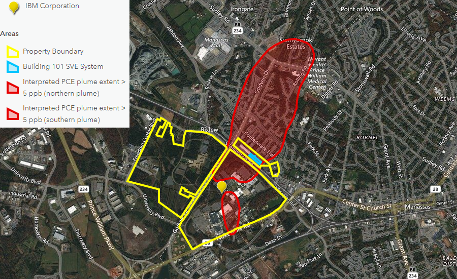

the chip-manufacturing plant in Manassas created a plume of groundwater contaminated with solvents, but the site does not qualify for the National Priorities List
Source: Environmental Protection Agency (EPA), Hazardous Waste Cleanup: IBM Corporation in Manassas, Virginia and Cleanups In My Community Map
Financial institutions were reluctant to approve loans for sites listed in CERCLIS, even after the Environmental Protection Agency had determined a site did not qualify for inclusion in the National Priorities List. The Environmental Protection Agency then moved sites which did not qualify to the CERCLIS Archive:3
The CERCLIS system was replaced in 2016 with the Superfund Enterprise Management System (SEMS), with a SEMS-Archive to document reported sites which were not on the National Priorities List.4
By August 2022, 36 sites in Virginia were part of the Superfund program. Of the 36, six had been added and then deleted, one was managed through an alternative to the National Priorities List, and 29 were still on the list:5
30 Sites in Virginia on National Priorities List
| Site Name | Jurisdiction |
|---|---|
| ABEX CORP. | City of Portsmouth |
| ARROWHEAD ASSOCIATES, INC./SCOVILL CORP. | Westmoreland Couny |
| ATLANTIC WOOD INDUSTRIES, INC. | City of Portsmouth |
| AVTEX FIBERS, INC. | Warren County |
| BUCKINGHAM COUNTY LANDFILL | Buckingham County |
| CHISMAN CREEK | York County |
| CULPEPER WOOD PRESERVERS, INC. | Culpeper County |
| DEFENSE GENERAL SUPPLY CENTER (DLA) | Chesterfield County |
| FORMER NANSEMOND ORDNANCE DEPOT | City of Suffolk |
| FORT EUSTIS (US ARMY) | City of Newport News |
| GREENWOOD CHEMICAL CO. | Albemarle County |
| H & H INC., BURN PIT | Hanover County |
| HIDDEN LANE LANDFILL | Loudoun County |
| KIM-STAN LANDFILL | Alleghany County |
| L.A. CLARKE & SON | Spotsylvania County |
| LANGLEY AIR FORCE BASE/NASA LANGLEY RESEARCH CENTER | City of Hampton |
| MARINE CORPS COMBAT DEVELOPMENT COMMAND | Prince William County |
| NAVAL AMPHIBIOUS BASE LITTLE CREEK | City of Virginia Beach |
| NAVAL SURFACE WARFARE CENTER - DAHLGREN | King George County |
| NAVAL WEAPONS STATION - YORKTOWN | York County |
| NORFOLK NAVAL BASE (SEWELLS POINT NAVAL COMPLEX) | City of Norfolk |
| NORFOLK NAVAL SHIPYARD | City of Portsmouth |
| NWS YORKTOWN - CHEATHAM ANNEX | York County |
| PECK IRON AND METAL | City of Portsmouth |
| RENTOKIL, INC. (VIRGINIA WOOD PRESERVING DIVISION) | Henrico County |
| SAUNDERS SUPPLY CO. | City of Suffolk |
| ST. JULIENS CREEK ANNEX (U.S. NAVY) | City of Chesapeake |
| SALTVILLE WASTE DISPOSAL PONDS | Smyth County |
| U.S. TITANIUM | Nelson County |
1 Site in Virginia With a Superfund Alternative Approach (SAA)
| Site Name | Jurisdiction |
|---|---|
| NASA WALLOPS FLIGHT FACILITY WALLOPS ISLAND, VA | Accomack County |
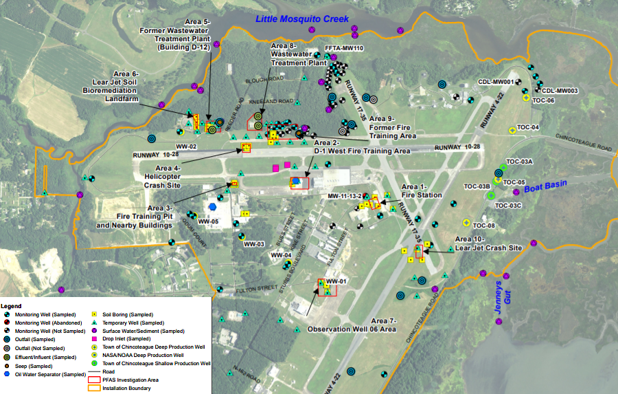
multiple sites were tested for contaminants at the Wallops Flight Facility
Source: National Aeronautics and Space Administration (NASA), Site Investigation Report
for Per- and Polyfluoroalkyl Substances (Figure 3-1)
6 Sites in Virginia Deleted From National Priorities List
| Site Name | Jurisdiction |
|---|---|
| C & R BATTERY CO., INC. | Chesterfield County |
| DIXIE CAVERNS COUNTY LANDFILL | Roanoke County |
| FIRST PIEDMONT CORP. ROCK QUARRY (ROUTE 719) | Pittsylvania County |
| MATTHEWS ELECTROPLATING | City of Roanoke |
| RHINEHART TIRE FIRE DUMP | Frederick County |
| SUFFOLK CITY LANDFILL | City of Suffolk |
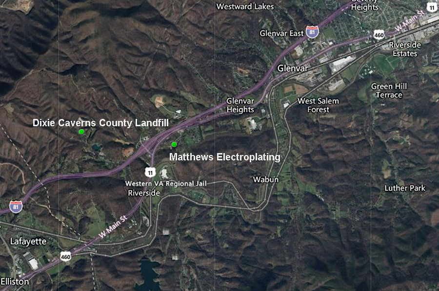
the National Priorities List no longer includes the Dixie Caverns County Landfill or the Matthews Electroplating site
Source: Environmental Protection Agency (EPA), Superfund National Priorities List (NPL) Where You Live Map
Since 2002, the Environmental Protection Agency has offered Potentially Responsible Parties (PRP's) the option of a Superfund alternative approach (SAA) agreement. The one site in Virginia overseen through that approach is the portion of the NASA Wallops Flight Facility formerly used by the US Navy, before the National Aeronautics and Space Administration (NASA) acquired the facility in 1959.
The Department of Defense is funding the cleanup of the Formerly Used Defense Site (FUDS) areas of the Wallops Flight Facility. The National Aeronautics and Space Administration is responsible for dealing with contamination from per- and polyfluoroalkyl substances (PFAS) which were in firefighting foam used in training and after a . The National Aeronautics and Space Administration and the Environmental Protection Agency agreed in 2020 to manage the site under the Federal Facility Superfund Alternative Approach, with National Aeronautics and Space Administration responsible for managing the cleanup of sites contaminated by both Federal agencies:6
In 2016, tests revealed that per- and polyfluoroalkyl substances (PFAS) were detected in three of the seven wells on the Wallops Flight Facility which supplied drinking water to the Town of Chincoteague. Those wells were closed and the National Aeronautics and Space Administration drinking water system was used to supply water to the town. After installing a using granular activated carbon treatment system to remove the contaminants, in 2021 the Town of Chincoteague was again able to use all of its deep and shallow wells for production.7
contaminants from firefighting foam affected drinking water wells at the Wallops Flight Facility
Source: National Aeronautics and Space Administration (NASA), Site Investigation Report
for Per- and Polyfluoroalkyl Substances (Figure 2-3)
Two of the 29 sites still on the National Priorities List had partial deletion actions by August, 2022:8
| Site Name | Jurisdiction |
|---|---|
| FORMER NANSEMOND ORDNANCE DEPOT | City of Suffolk |
| RENTOKIL, INC. (VIRGINIA WOOD PRESERVING DIVISION) | Henrico County |
The Environmental Protection Agency (EPA) plans for all contaminated sites to be cleaned up, rather than to be permanently abandoned with no productive use. After remediation, formerly-contaminated sites ("brownfield" sites in contrast to undeveloped "greenfield" sites) will become available for other uses. Every five years, the Federal agency reviews the status of cleanups at each listed site.
Complete remediation would allow for unlimited use and unrestricted exposure (UU/UE), with no restrictions placed on the potential use of land or other natural resources. Less-than-complete remediation still allowed for limited use, allowing a brownfield to be used for constructing a building but not as farmland for growing vegetables. By 2021, nine sites in Virginia were being re-used in some fashion:9
- Abex Corp.
- Arrowhead Associates, Inc./Scoville Corp.
- Avtex Fibers, Inc.
- C & R Battery Co., Inc.
- Chisman Creek
- Culpeper Wood Preservers, Inc.
- Dixie Caverns County Landfill
- Saunders Supply Co.
- U.S. Titanium
by 2021, reuse of once-contaminated land has occurred at nine brownfield sites in Virginia
Source: Environmental Protection Agency (EPA), Superfund Sites in Reuse in Virginia
At the Rentokil site in Henrico County, all of the wood treating equipment was removed from the site in 1991 and neighbors with wells were connected to a municipal water system. In 2009 a portion of the site contaminated with pentachlorophenol (PCP), creosote, chromated copper arsenate, chromated zinc arsenate, xylene, and fire retardants was deleted from the National Priorities List to facilitate industrial/commercial development. The Federal agency deleted former Wetland Areas B and C and the groundwater at former Wetland Area C, but retained the rest of the site (including groundwater at Wetland Area B) on the National Priorities List.10
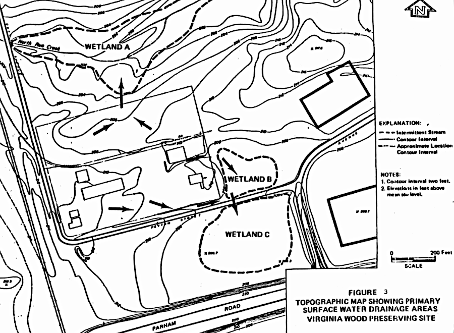
a partial deletion of the Rentokil site from the National Priorities List allowed for industrial/commercial development on a portion of the brownfield
Source: Environmental Protection Agency (EPA), Rentokil, Inc. (Virginia Wood Preserving Division) Richmond, VA Cleanup Activities
Reuse of a once-contaminated brownfield site involves non-standard risks compared to developing a greenfield site. The Jordan Bridge was rebuilt across the Southern Branch of the Elizabeth River through the Atlantic Wood Industries site contaminated with creosote, pentachlorophenol, polynuclear aromatic hydrocarbons, dioxins and metals. In the process, the contractor excavating and disposing of the sediment in the Elizabeth River stacked it too close to the piers of the Jordan Bridge. Three of them shifted between 1.5 -3.5 inches, but the displacement was still within safety tolerances for the bridge.11
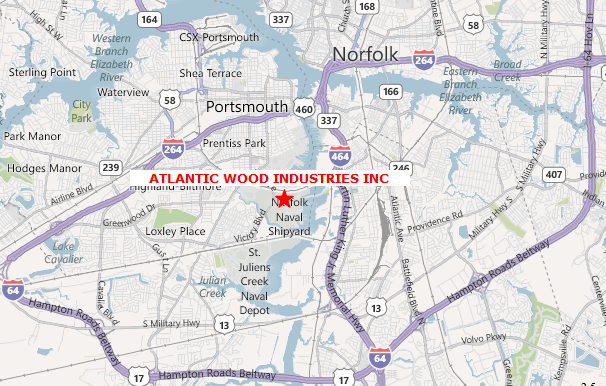
Atlantic Wood Industries in Portsmouth, VA
Source: Environmental Protection Agency
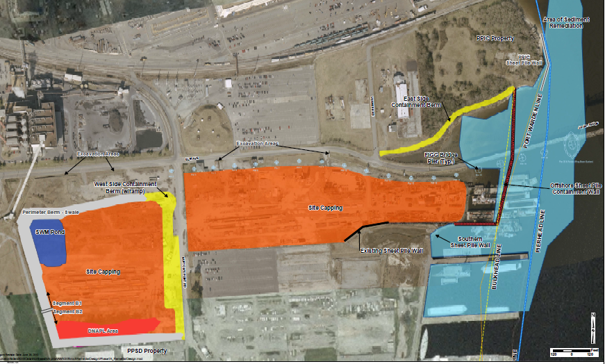
Atlantic Wood Superfund site, where contaminated sediments will be excavated and stored at Atlantic Wood Superfund site (City of Portsmouth)
Source: Environmental Protection Agency Atlantic Wood Industries, Inc
Six Superfund sites in Virginia have been removed from the Superfund list after remediation was completed.
In 2022, the Environmental Protection Agency (EPA) removed the C&R Battery Company from the Superfund list. That facility had dismantled lead car/truck batteries in order to recover the metal. Soil was contaminated as acid was drained from the batteries. The site was on the Superfund list from 1987-2022.12
In 2024, cleanup began of the Hidden Lane Landfill Superfund site in Loudoun County. The landfill operated between 1971-1984, and had been placed on the Superfund list in 2008. Trichloroethylene (TCE) in the soil at the base of the landfill had leached into the groundwater and contaminated nearby wells. The Proposed Remedial Action Plan was issued in 2021.
In the Broad Run Farms community, 40 houses had treatment systems installed on private wells. As part of the 2024 cleanup, another 100 houses were connected to the public water system in order to eliminate their use of groundwater. The connection fee, $8,000 per house, was part of the $8 million cleanup cost.13
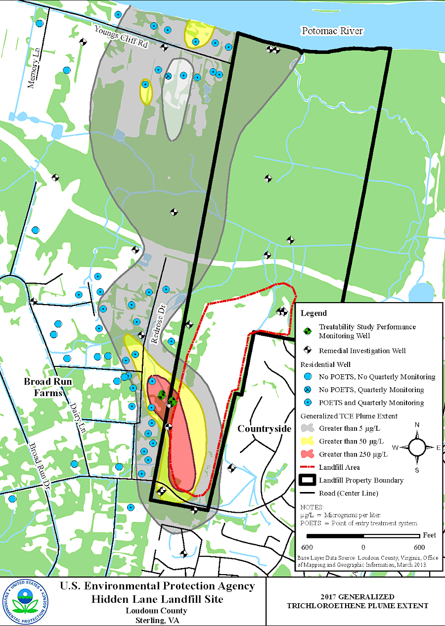
the Hidden Lane Landfill cleanup began in 2024
Source: Environmental Protection Agency Hidden Lane Landfill NPL Site Interim Action Proposed Plan Public Meeting (April 26, 2018)
Superfund sites in Virginia
Source: Virginia's Land and Energy Navigator (VALEN)
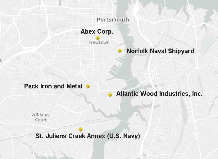
five sites along the Elizabeth River are on the National Priorities List
Source: Environmental Protection Agency (EPA), Superfund National Priorities List (NPL) Where You Live Map