Where Are the Appalachians?
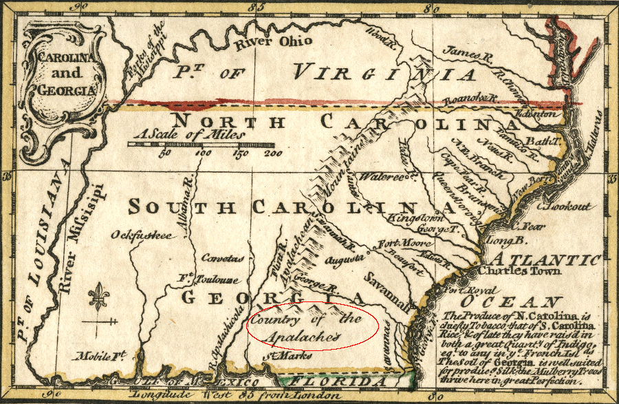
the Spanish discovered the Appalachee near modern Tallahassee, Forida, and the name of the group of Native Americans was applied to the mountains to the north
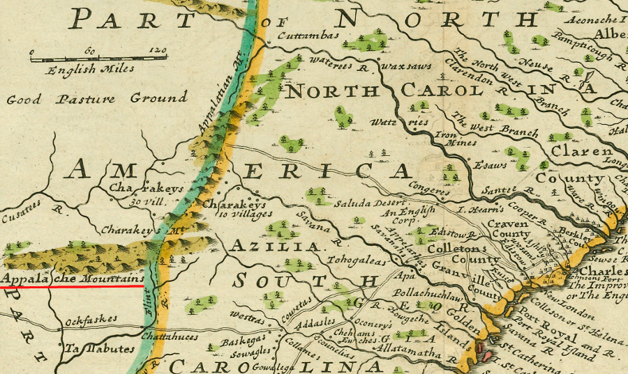
Source: David Rumsey Historical Map Collection, Carolina And Georgia (by Emanuel Bowen and John Gibson, 1758)
The Appalachians are named after the Appalachee, a Native American tribe that lived at modern-day Tallahassee, Florida.
The Appalachee traded with other Native American tribes to the east. Those eastern tribes traded with the French, after a Huguenot group established a colony at Fort Caroline in 1564. The colonists believed that the copper sold by their traders originally came from the mountains where the Appalachee lived.
Nearly all of the French colonists were killed by the Spanish when they destroyed the colony started by the "heretic" Protestants from a rival European nation. Jacques Le Moyne managed to escape and get back to Europe, where he is thought to have recreated his maps and sketches. He also reported that gold, silver, and copper were in the mountains.
Later mapmakers, and then explorers who encountered mountains west of the Coastal Plain, called them the Appalachians.1
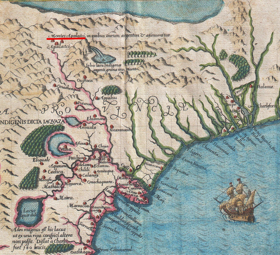
Jacques Le Moyne's widow sold his materials to Theodore de Bry, who produced a map in 1591 that included "Montes Apalatci"
Source: Geographicus, De Bry and Le Moyne Map of Florida and Cuba (by Theodore de Bry, 1591)
Physically, the "mountains" of Virginia start at the Blue Ridge, but defining the Appalachians vs. the Blue Ridge vs. the Alleghenies is a judgment call. The cultural terms for the Appalachians mountains does not always match the geological distinctions.
The "Valley and Ridge Province" extends between the Blue Ridge and the Allegheny Front, and stops at the edge of the Allegheny Plateau. If a person lumps the Blue Ridge in with the mountains of West Virginia and Kentucky, then Floyd County, Mount Rogers, and Galax are part of the Appalachians - but should the New River Valley and Bristol be included? If a person splits out the various provinces so only the Allegheny Plateau west of the Allegheny Front qualify as "Appalachia," then what is the appropriate label for the cultural patterns of the Blue Ridge (including mountain music and moonshine)?
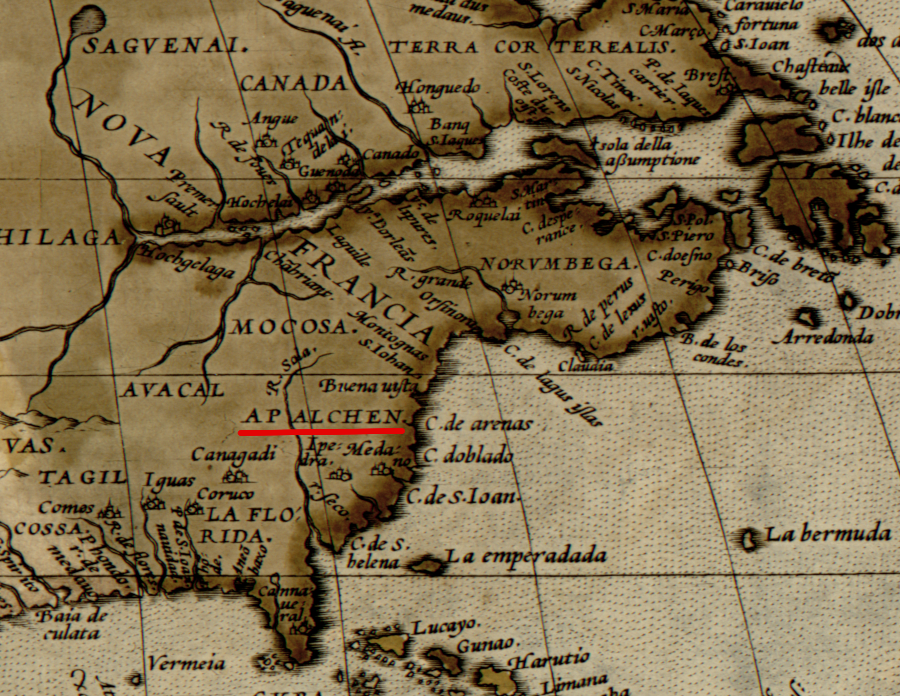
in 1570, Abraham Ortelius applied the named used by Jacques Le Moyne to the region inland from the Atlantic coastline
Source: Library of Congress, Theatrum orbis terrarum, Americae sive novi orbis, nova descriptio (by Abraham Ortelius, 1570)
Where you grow up might makes a difference. People who grow up in the Shenandoah Valley or the New River Valley don't always assume the mountains are to the west. Residents of Blacksburg or Roanoke may refer to specific mountains - Tinker Mountain, Brush Mountain, etc. - rather than say "I'm going mountain biking in the Blue Ridge on Saturday."
Virginian who grow up near the Fall Line or in Tidewater, are more likely to be "lumpers" who call all those bumps to the west the Appalachians. In contrast, those who grow up west of Route 15 are probably "splitters" who distinguish the Blue Ridge from the Appalachian Plateau, and consider the Shenandoah and other valleys in-between to be a unique region. Alleghany County could be considered part of the Allegheny Mountains, even though there spelling is not consistent - and much of the county is, geologically, in the Valley and Ridge physiographic province.
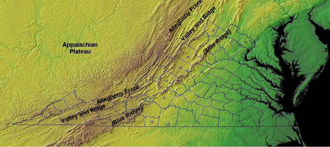
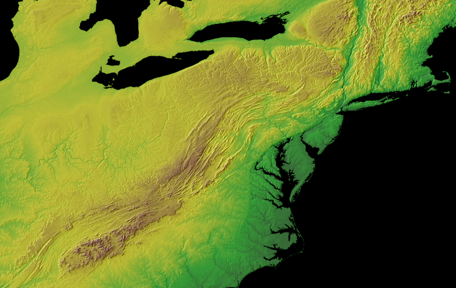
Virginia topography and geology defines physiographic provinces, but people can define regional boundaries by cultural as well as physical patterns
Source: National Oceanographic and Atmospheric Administration (NOAA), The Global Land One-kilometer Base Elevation (GLOBE), Project Conterminous 48 USA states
bedrock deformed by the collision of the North America and Africa tectonic plates roughly 300 million years ago has been shaped by erosion since then, and now form a range of mountains stretching from Georgia to the Maritime provinces of Canada
Source: National Oceanic and Atmospheric Administration, GLOBE: A Gallery of High Resolution Images
the name of a Native American group in Florida was applied to the mountain range stretching towards the north
Source: J. Carter Brown Library, Carolina (by Herman Moll, c.1763)
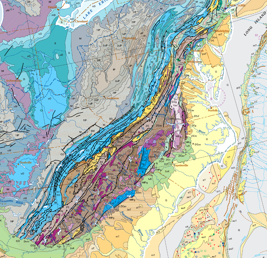
from a geological perspective, the Appalachians extend north into Canada and south into Alabama
Source: US Geological Survey (USGS) and Geologic Society of America (GSA), Geologic Map of North America - South
From a geologic perspective the Blue Ridge, the Valley and Ridge province, and the Appalachian Plateau are distinctly different.
The one billion year old core of the Blue Ridge was created during the Grenville orogeny, perhaps when the supercontinent Rodinia formed. The Blue Ridge core rocks are igneous rocks, with a coating of younger volcanic lava that was later metamorphosed. The Blue Ridge's core bedrock was created during a mountain-building episode when tectonic plates collided.
In contrast, just to the west in the Shenandoah Valley are sedimentary layers that are only half the age of the Blue Ridge granite and grandiorite. The limestones in the Valley and Ridge physiographic province are "only" 500 million years old, dating from the Cambrian Period or even later. The oldest of those sedimentary layers were deposited in a peaceful ocean environment at the edge of a continental plate, comparable to the setting of the Bahamas today.
the limestone formations in the Valley and Ridge province were deposited on the edge of the tectonic plate before the collision with Africa
Source: Ron Blakely, Paleogeography and Geologic Evolution of North America - Late Cambrian (500Ma)
Further west, the rocks in the Appalachian Plateau are also less than half the age of the core of the Blue Ridge, and most sedimentary layers in the Appalachian Plateau are younger than the rocks exposed in the Valley and Ridge. The layers in the Appalachian Plateau are also flat. The energy of the collision between Africa-North America roughly 300 million years ago tilted and twisted the sedimentary layers in the Valley and Ridge province, but further west the layers were not crumpled by the energy is the tectonic collisions. Erosion has stripped away more of the layers in the Valley and Ridge province, while younger rocks remain in the Appalachian Plateau.
One other distinction between the Blue Ridge and the Appalachian Plateau: the Blue Ridge has been pushed westwards perhaps 40 miles by the collision with Africa. It appears to have broken free from its original roots to the Grenville-age basement, and been shoved west on top of the younger rocks exposed now in the Shenandoah and New River valleys. The rocks of the Appalachian Plateau have drifted with the rest of the continental plate, but have not been shoved from their original site of deposition.
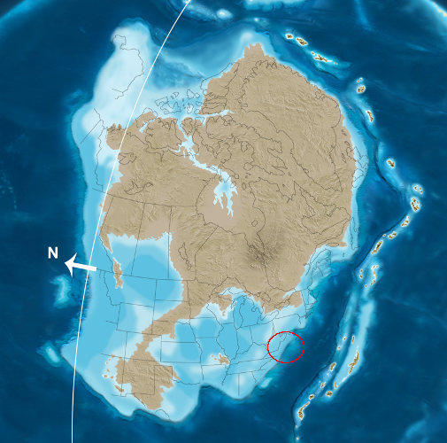
If considered as a mountain chain rather than as a cultural region, the Appalachians are also located in Canada, Greenland, Ireland, Scotland, Scandinavia, and Africa. The mountains uplifted by the creation of Pangea were divided when the supercontinent broke up. As the Atlantic Ocean formed, portions of the Appalachians moved with the shifting tectonic plates to new locations.2
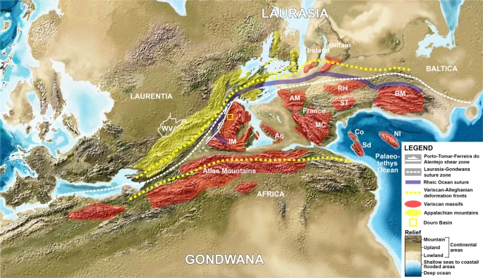
the Appalachian Mountains which were created with Pangea are - geologically - on both sides of the Atlantic Ocean now
Abbreviations: WV: West Virginia; IM: Iberian Massif; Aq: Aquitaine; AM: Armorican Massif; MC: French Central Massif; RH: Rheno-Hercynian terrane; ST: Saxo-Thuringian terrane; BM: Bohemian Massif; Sd: Sardinia (Italian island); Co: Corsica (French Mediterranean island); NI: Variscan basement of northern Italy.
Source: Scientific Reports, Iberian-Appalachian connection is the missing link between Gondwana and Laurasia that confirms a Wegenerian Pangaea configuration (Creative Commons license)
References
1. "1591 De Bry and Le Moyne Map of Florida and Cuba," Geographicus, https://www.geographicus.com/P/AntiqueMap/Florida-debry-1591; Joyce Rockwood Hudson, Apalachee, University of Georgia Press, 2012, p.394, https://books.google.com/books?id=Gg_E7z55SYsC (last checked December 8, 2017)
2. Pedro Correia, J. Brendan Murphy, "Iberian-Appalachian connection is the missing link between Gondwana and Laurasia that confirms a Wegenerian Pangaea configuration," Scientific Reports, Volume 10, Article number: 2498 (2020), https://doi.org/10.1038/s41598-020-59461-x (last checked June 13, 2022)
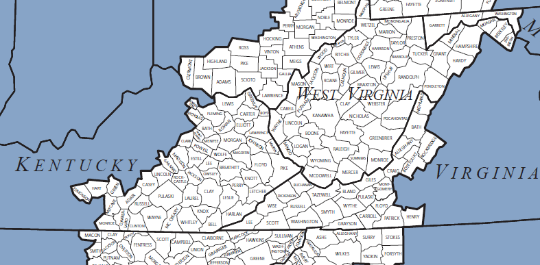
none of the northern Blue Ridge counties in Virginia north and east of Rockbridge ended up within the Appalachian Regional Commission boundaries
Source: Appalachian Regional Commission, The Appalachian Region
Regions of Virginia
Rocks and Ridges - The Geology of Virginia
Virginia Places