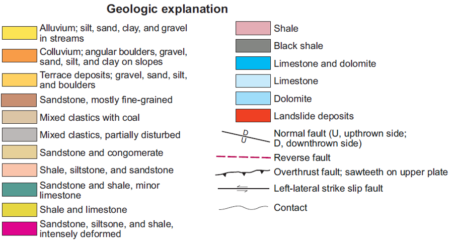
bedrock at Cumberland Gap consists of sedimentary layers, disrupted by thrust faulting and even a meteorite impact
Source: Kentucky Geological Survey, Geology of Cumberland Gap National Historical Park
bedrock at Cumberland Gap consists of sedimentary layers, disrupted by thrust faulting and even a meteorite impact
Source: Kentucky Geological Survey, Geology of Cumberland Gap National Historical Park
Cumberland Gap is a crack in Cumberland Mountain. The bottom of the gap, at 1600 feet in elevation, is 400 feet lower than the ridge top to the south, including the summit of Tri-State Peak.1
The bedrock consists of sedimentary layers deposited between 416-300 million years ago, when the area was at the edge of the North American continental plate. Limestones accumulated below the Sauk Sea and Tippecanoe Sea, while shales and sandstones were deposited in foreland basins during the Taconic and Neo-Acadian orogenies. The flat-lying sediments were thrust westward and tilted 40° to the northwest during the Alleghenian Orogeny.
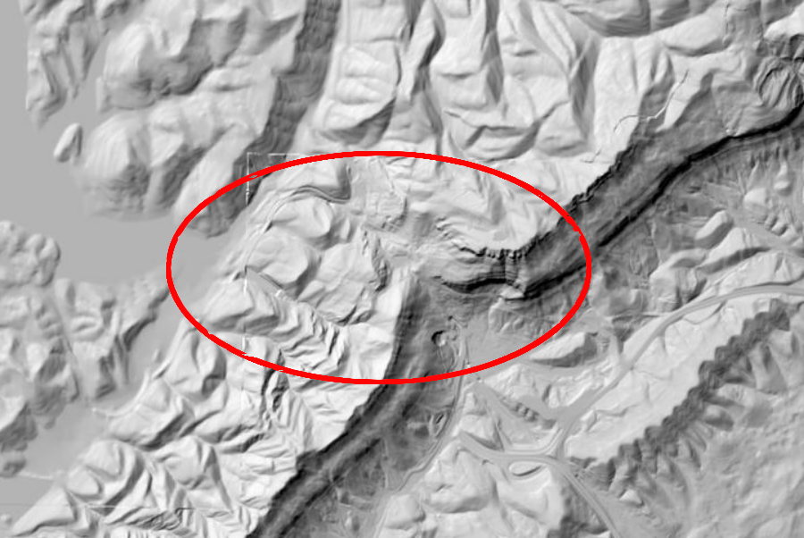
In the course of the trusting and tilting, the Pine Mountain Thrust Sheet cracked. The Rocky Face Fault weakened the bedrock where it intersected the Pine Thrust Fault, and erosion created a low gap through the sandstone ridges that form Cumberland Mountain and Pine Mountain. Cumberland Mountain created a 100-mile long barrier, but Cumberland Gap in the Allegheny Front opened a "vital gateway to the west during the early expansion of the United States."
An asteroid slammed into the Earth's crust 300 million years ago, roughly at the same time that Pangea formed and the Pine Mountain Thrust Sheet was shoved inland. The impact created the depression in which the town of Middlesboro, Kentucky is now located, and the stresses in the bedrock simultaneously formed a serious of faults around the circular basin. When cracks in the bedrock from the asteroid impact and the Rocky Face Fault created during the formation of Pangea were later exposed to more-recent erosion, a zone of weakness led to the formation of Cumberland Gap.2
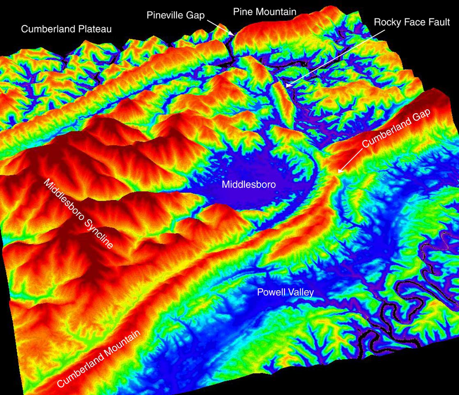
a digital elevation model (DEM) reveals the Middlesboro Bason and shows that Cumberland Gap and Pineville Gap are features of the Rocky Face Fault
Source: Kentucky Geological Survey, Field Guide to the Middlesboro and Flynn Creek Impact Structures (Figure 3)
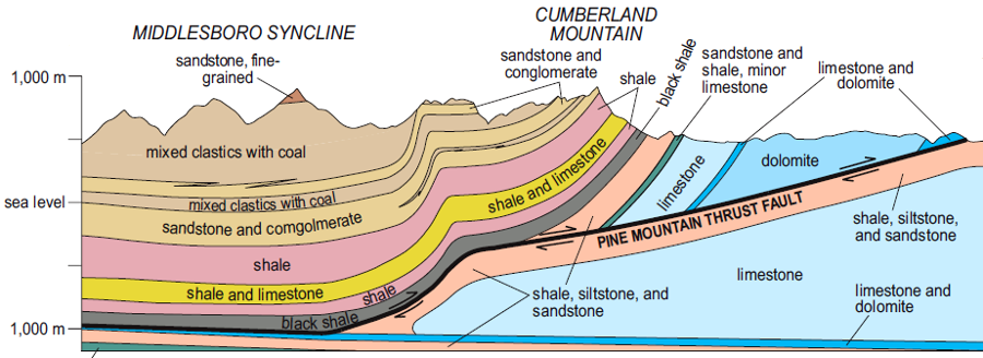
The Pine Mountain Thrust Sheet (also known as the Cumberland Overthrust Sheet) is a block of sedimentary rock about 4,000 feet thick and roughly 125 miles on each side. It was broken free, pushed up and over adjacent rocks, then forced westward and rotated during the collision between tectonic plates called the Alleghenian Orogeny.
Each of the four sides is marked by faults, where the block of crust was cracked free and displaced. The leading edge on the northwest is now known as the Pine Mountain Thrust Fault. The southwestern edge moved 11 miles, while the northeastern end moved 4 miles. The block is folded in the middle, with once-flat sedimentary layers bent down to form the Middlesboro Syncline.3
Many such blocks of rock were cracked free, then pushed on top of the same sedimentary layers that had once been next-door neighbors. If you cut a ham and cheese sandwich and slide one half sideways and on top of the other, you can create the equivalent of a thrust sheet.
Gondwana (northwest Africa) and Laurentia (North America) merged to create the supercontinent Pangaea. Gondwana slid up and over the Avalon and Taconic terranes that had previously been accreted to the edge of Laurentia in the Taconic and Neo-Acadian Orogenies, cracking them free and sliding them west over the limestones, shales, and sandstones that had accumulated in the Sauk, Tippecanoe, and Kaskaskia seas. Rock formations that had once been adjacent to each other as horizontal neighbors ended up being cracked and stacked vertically, and tilted as well.
Gondwana compressed the continent like a musician squeezing an accordion, and "Africa" ended up on top of "North America." The edge of Africa may have sat on top of North America as far west as modern-day Kentucky, 300 million years ago.
Those rocks have eroded away. What was once part of Gondwana, pushed up and over the edge of Laurentia, has been washed downstream and blown downwind to create younger sedimentary layers in the Mississippi Valley and on the Coastal Plain.
The front edge of the thrust sheet is the Pine Mountain Thrust Fault, at the base of Pine Mountain. It may mark where deformation from continental collision finally stopped, as the energy of the tectonic collision was dissipated by folding and faulting of sedimentary layers in the Valley and Ridge province.
The Pine Mountain thrust sheet was bent, twisted, and cracked as it was pushed up and slid for miles across the top of rocks that had once been adjacent. Erosion has stripped away overlying formations. The sandstone-rich Lee Formation has been slower to erode, and today forms the ridges of Pine Mountain and Cumberland Mountain.
Cutting through the mountains is an ancient crack in the thrust sheet, the Rocky Face Fault. Differential erosion has carved the Pineville and Cumberland gaps where that fault weakened the bedrock. The Cumberland River still flows through Pineville Gap. Cumberland Gap is now being eroded on the west side by Little Yellow Creek, and on the east by Gap Creek.4

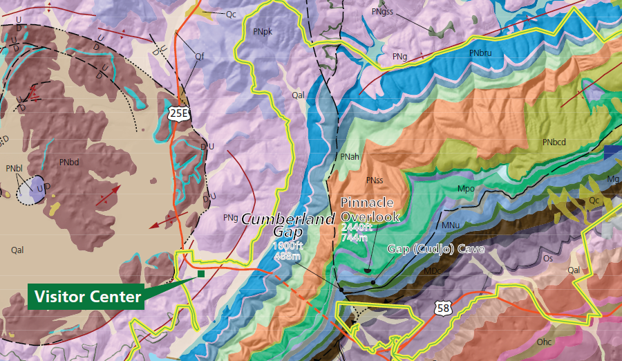
Pinnacle Overlook is in sandstone, while the caves underneath are in limestone
Source: National Park Service, Gap Cave – A Primer
The cap rock at the top of Cumberland Mountain is formed by the Pennington and Lee sandstone formations. Across the state boundary in Kentucky, erosion in the sandstone has created an overhand known as Sand Cave.
Within the Greenbrier Limestone formation, groundwater has etched out over 30 caves. There are vertical shafts as deep as 125 feet, and the longest connected cave system extends for 16 miles.
Soldier's Cave got its name in the Civil War, when Union and Confederate troops occupied Cumberland Gap.
Gap Cave, the only one open to the public, evolved in the 500' thick Newman formation. The stream coming out of its entrance made it easy to find as soon as humans reached the area. The first documented record dates from the visit of Dr. Thomas Walker in 1750.
Gap Cave has five levels, reflecting how changes in groundwater levels, carved the karst topography in the last 3-5 million years. The National Park Service notes:5
In 1888, the owner of the land with the cave blasted out a new entrance and created a commercial attraction known as King Solomon's Cave. When Lincoln Memorial University purchased the land in 1920, it renamed the geological feature Cudjo's Cave. Soldier's Cave was illuminated with electric lighting in 1934 to attract more visitors during the Great Depression, and a tunnel excavated to connect it to Cudjo's Cave.
The National Park Service purchased Cudjo's Cave in 1992 and continued public tours. The Federal agency considers the graffiti carved and scrawled on the walls to be a historic resource, with items older than 50 years protected under the Antiquities Preservation Act. Public tours have been continued, but the electric lighting was removed to stop the growth of algae on the cave formations.6
Cumberland Mountain is part of the Pine Mountain thrust sheet
Source: Kentucky Geological Survey, Geology of Cumberland Gap National Historical Park
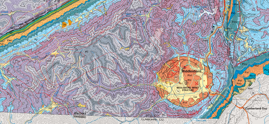
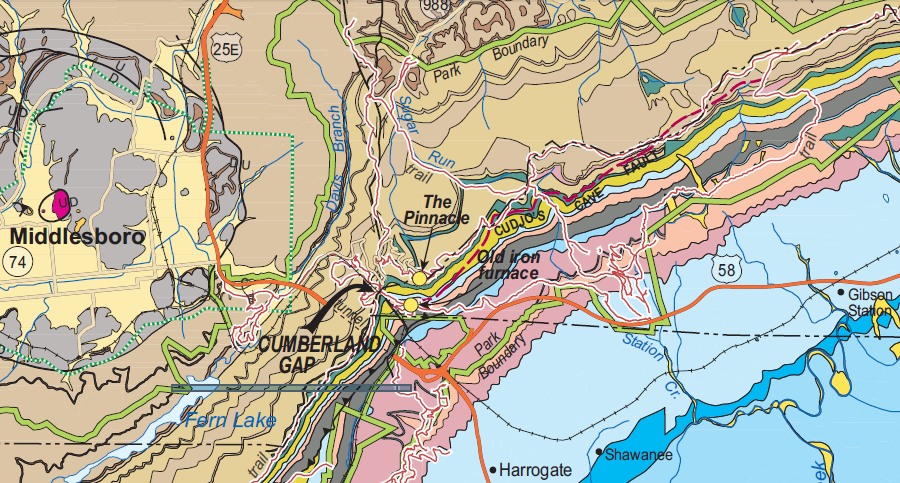
Cumberland Gap is located east of the Middlesboro impact structure and the edge of Pine Mountain Overthrust Fault
Source: Kentucky Geological Survey, Geologic map of the Middlesboro and part of the Bristol 30 x 60 minute quadrangles, southeastern Kentucky
Cumberland Gap is located east of the Middlesboro impact structure and the edge of Pine Mountain Overthrust Fault
Source: National Park Service, Digital Geologic Map of Cumberland Gap National Historical Park and Vicinity, Kentucky, Tennessee and Virginia
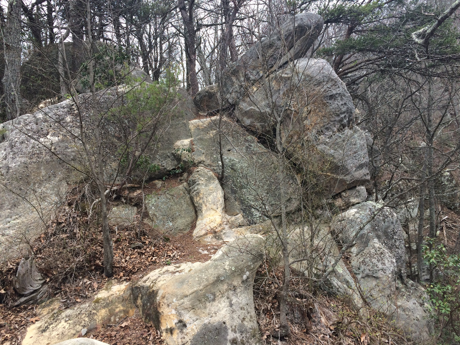
Cumberland Mountain is formed from a slower-to-erode sandstone conglomerate, the Lee Formation
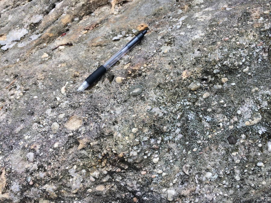
the Lee Formation is a conglomerate
Daniel Boone cut a road through Cumberland Gap, the lowest spot possible, to facilitate settlement of Kentucky
Source: US Geological Survey, National Map