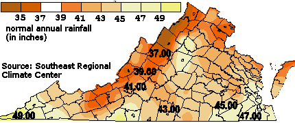
average normal rainfall, 1971-1990
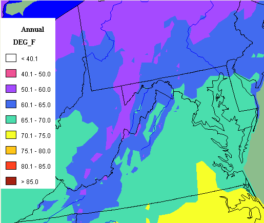
The greatest rainfall and warmest temperatures are in the southeast corner of the state, where the Chesapeake Bay and the Atlantic Ocean provide warmth and moisture. There is also a rain shadow in the southern ("upper") Shenandoah Valley, which receives 10 inches less rain in an average year than the Dismal Swamp in the cities of Suffolk and Chesapeake.
average annual precipitation for Virginia is 42-43 inches - but there are areas (rain shadows) near the mountains that receive significantly less
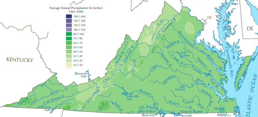
Source: US Geological Survey National Atlas
Why is there a rain shadow in the Shenandoah Valley and the New River Valley, but not near Norfolk? Mountains in West Virginia force the winds in the jet stream coming from the Pacific Ocean, and storms from the Gulf of Mexico, to move higher in elevation. Air pushed up in elevation cools to the "dew point" where moisture condenses and clouds form.
Rain falls from those clouds in West Virginia, and the remaining relatively-dry air blows over the Shenandoah Valley and the New River Valley. In the winter, the moisture dals as snow. Ski resorts are concentrated in West Virginia, especially near Canaan Valley, in order to take advantage of the extra snowfall.
On the eastern edge of the Shenandoah Valley and New River Valley, the Blue Ridge forces air currents bringing moisture from the Atlantic Ocean to move up in elevation. The moisture falls as rain and snow on those mountains, and the remaining relatively-dry air blows over the Shenandoah Valley and the New River Valley.
Warm air can hold more moisture than cool air. When people take a shower, the warm air quickly cools when it hits the mirror in the bathroom, so moisture condenses and fogs up the mirror. The same thing happens on a larger scale outdoors. When the sun goes down in the evening, the air in the neighborhood cools. In Virginia during the summer, the air may cool enough to reach dew point and leave a film of moisture on windshields. In the winter, frost may form on a car windshield when it is close to 32 degrees Fahrenheit.
There is an "orographic" or mountain effect when air masses are pushed up by the Appalachians or Blue Ridge. The air cools as it rises, at an adiabatic lapse rate of approximately 3 degrees per 1,000 feet in Virginia.
In theoretically dry air the adiabatic lapse rate is 5.4°F/1,000 feet rise in elevation, but moisture in the air affects the rate of cooling. The "wet" adiabatic lapse rate varies based on the amount of moisture and the temperature of the air, ranging between 2.2°F/1,000 feet to 3.8°F/1,000 feet rise in elevation.1
The mountains essentially squeeze the clouds the way a kitchen worker might squeeze a sponge, extracting the moisture before it can fall on the Shenandoah Valley or New River Valley. Since North American air masses typically come from the west due to prevailing winds, extra rain and snow often falls in West Virginia.
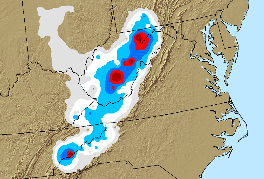
Superstorm Sandy brought a major snowfall to West Virginia
Source: National Oceanographic and Atmospheric Agency (NOAA), National Overview - October 2012 Sandy precipitation totals
When the relatively-dry air crosses the Allegheny Front at North Mountain on the western border of Shenandoah and Frederick counties, it drops into the Shenandoah Valley. Just as it cooled at the adiabatic lapse rate, it also warms when it drops in elevation. The effect of the "rain shadow" is magnified by the warm air, drying the valley soils east of the Appalachians.
The rain shadow works in both directions. When Hurricane Fran crossed from North Carolina through the Virginias into Ohio, the mountains squeezed the clouds on the eastern side of the Blue Ridge and a second time at the Allegheny Front. That generated both massive amounts of rain in Virginia and a very reduced amount of rain in the Ohio River Valley, until the storm regained strength and drenched central Ohio.
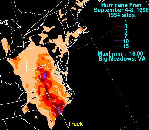
orographic effects from Hurricane Fran - 16" of rain at Big Meadows
Source: National Weather Service, Hurricane Fran - September 4-8, 1996
"Virginia's Climate" says:2
The adiabatic lapse rate is obvious in the average temperatures as well as the average precipitation statistics. In the days before air conditioning, wealthy Virginians would travel to the resorts in the Blue Ridge and the mountains west of the Shenandoah Valley. The hot springs and mineral springs were thought to have a therapeutic effect, in the days before modern medical cures. However, the cooler temperatures and less-humid air were clearly more comfortable than the hot, muggy coastal plain, even for those who did not get in the naturally-heated water.
In addition, summer mosquitoes spread yellow fever in Norfolk, Richmond, and Alexandria, carrying disease from sailors infected in other ports. Spending summer in the mountains was more comfortable, and healthier for those who could afford to get away from infected sailors and the disease-transmitting mosquitoes.
Why didn't the rich Virginians vacation at Virginia Beach in the summer before the Civil War? One reason: there was no easy way for vacationing families loaded with luggage to get to the oceanfront until a resort developer finally built a railroad from Norfolk to the Atlantic Ocean in the 1880's.
More significantly, the houses near the beaches of Princess Anne County were still hot and muggy in the summer. Only after World War II, once air conditioning allowed tourists to beat the heat indoors, did Virginia Beach became a major destination resort for summertime recreation.
1. Milton Beychok, "Atmospheric lapse rate," The Encyclopedia of Earth, last updated March 31, 2013, http://www.eoearth.org/view/article/170859/ (last checked October 13, 2015)
2. "Virginia's Climate," University of Virginia Climatology Office, http://climate.virginia.edu/description.htm (last checked September 13, 2014)