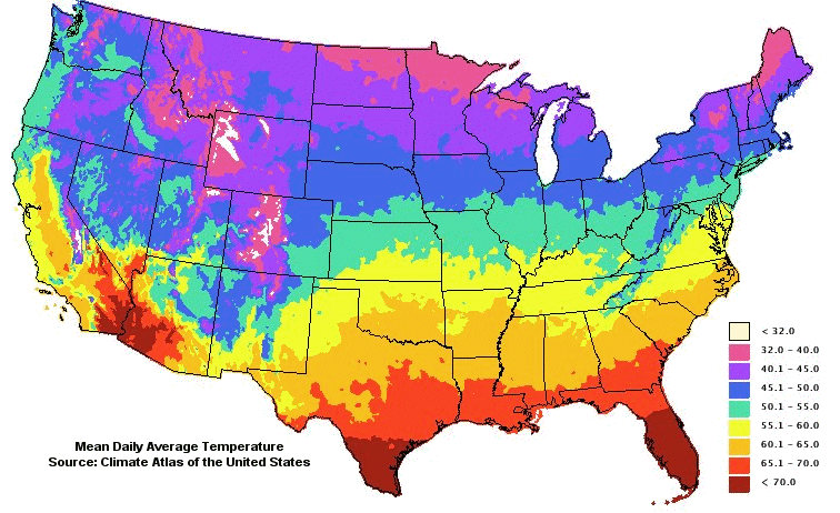
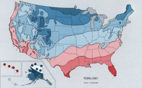
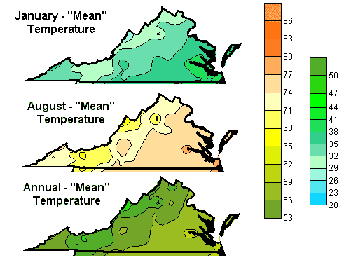
the Mean Daily Average Temperature on Virginia's coastline differs from the average temperature in the mountains along the western edge
Source: National Oceanic and Atmospheric Administration (NOAA), Climate Atlas of the United States
"Climate is what you expect; weather is what you get"
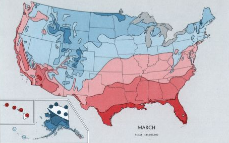
the Mean Daily Average Temperature on Virginia's coastline differs from the average temperature in the mountains along the western edge
Source: National Oceanic and Atmospheric Administration (NOAA), Climate Atlas of the United States
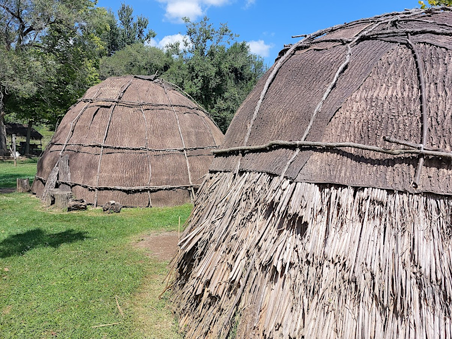
Modern residents consider Virginia to be a four-season state. The Native Americans first encountered by the colonists at Jamestown in 1607 defined five separate seasons, based on the cycles of growing, gathering, and storing food.
The end of winter and beginning of spring was popanow. In that season, the Native Americans relied upon food they had previously stockpiled. If the corn crop had been poor, the winter meals would rely upon stored fruits such as persimmons, nuts and acorns, and stews with dried fish, meat, and whatever items might be available. There were no apples or honeybees to provide sweets; those invasive species had not been introduced yet.
The arrival of anadromous fish marked the beginning of cattapeuk, the time in early spring when crops could be planted. Women would wade into rivers and use their feet to extract tuckahoe tubers, a rich source of carbohydrates. Rising sap made it easier to strip bark from trees, for use in repairing a family's yi-hakin or building a new house.
The cohattayough season stretched until mid-summer. Crops required attention in the fields, with people pulling weeds and guarding the fields to scare away animals interested in eating the plants. Cohattayough was also a good time for foraging in the woods, so on some days just a few people were left in the towns to protect the crops.
Harvest time at the end of summer was known as nepinough. Corn fields had been planted several weeks apart, so harvest stretched across several weeks as the plants matured.
At the end of the harvest, the new taquitock season was marked by ritual celebrations. This was also hunting season; towns were abandoned for communal hunts. The deer and other meats and skins were processed during taquitock, and food stockpiled for the coming popanow season. The availability of food, the dryness of trails, and the openness of the woods as leaves fell also made taquitock a favored time for raids between rival groups.1
in the cattapeuk season when sap was rising, Native Americans stripped bark from trees to repair/replace their yi-hakin
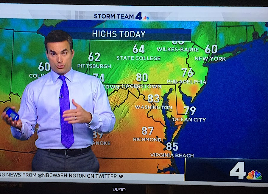
However one might classify the seasons, August days are on average hot and humid, while January days are typically cold and dry. The warmth in the air in early Spring, and the chill in the air in the Fall, "feel" different from other seasons. That is the climate pattern.
People planning an outdoor event for any particular day in August or January need to check the weather prediction within just a few days of the event, to calculate the probable temperature and chance of precipitation for that one day. Weather varies far more than climate. Computer models struggle to predicts the path of hurricanes more than 72 hours from the present, and the American and European computer models provide different results. Artificial intelligence may improve accuracy, but weather will always be "what's happening now."
In contrast to weather, climate is defined by long-term averages. Weather changes rapidly within 24 hours, but climate changes gradually over the decades. Weather patterns repeat themselves, such as hot and humid summers. When patterns change (as opposed to daily weather conditions), then the climate has changed.
It requires many measurements, averaged out, to document if climate change is trending towards an ice age or global warming. The National Oceanic and Atmospheric Administration (NOAA) measures climate in 30-year averages known as "climate normals." The 1961-1990 climate normal and the 1971-2000 climate normal were slightly different, because the climate shifted slightly.
When the 1991-2020 "new normal" was released it 2021, average temperatures were a half-degree higher than in the 1981-2010 climate normal. The averages reflected that 2010-2020 was the hottest decade recorded since documentation became consistent in 1880. The National Oceanic and Atmospheric Administration has also created new multi-year averages, in addition to the 30-year climate normal average, to illustrate how the climate was changing over time.
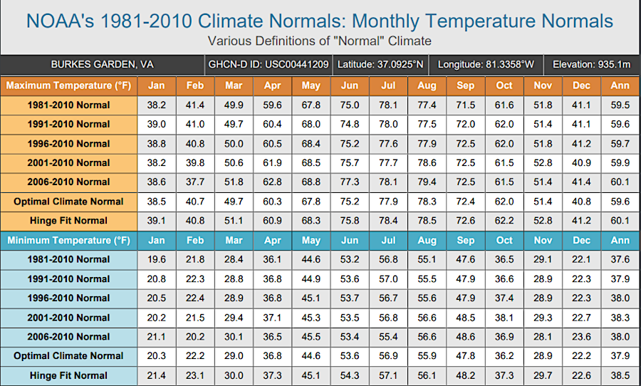
starting in 2021, National Oceanic and Atmospheric Administration provided multiple estimates of monthly temperature normals using different definitions of "normal"
Source: National Oceanic and Atmospheric Administration (NOAA), Supplemental Monthly Temperature Normals
Newscasts typically report whether temperatures are above or below normal. The latest climate normal is the basis for those reports. The shift in the climate normal each decade resets the baseline, and that obscures the trend of global warming. However, most people remember only the last two-eight years as "normal," using a timeframe even shorter than the last 30 years.2
The National Weather Service has divided the continental United States into 344 climate divisions, with six in Virginia, to document monthly temperature and precipitation values.
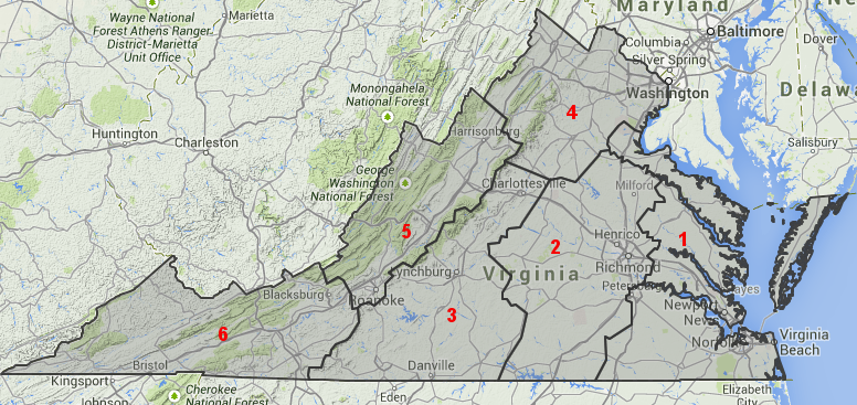
there are six climate divisions in Virginia: 1) Tidewater, 2) Eastern Piedmont, 3) Western Piedmont, 4) Northern, 5) Central Mountain, 6) Southwestern Mountain
Source: National Climatic Data Center, Climate Data Online
The Virginians paying the most attention to climate change may be on the coastline, anticipating sea level rise - but the operators of ski resorts are also concerned. As the climate warms, the capacity to offer good skiing before the Christmas holidays becomes less reliable and the ski resorts have to emphasize summertime hiking, zip lines, etc.
Just to the west of Winchester, Canaan Valley (West Virginia) gets 100 inches of snow annually. That helps to support looooooooong ski seasons that are the envy of ski resort owners less than 70 miles away in Virginia. The Virginia ski resorts get 25-50% of that total, and must manufacture snow at Massanutten, Bryce, or Wintergreen.
winter storms from the Great Lakes and Gulf Coast drop 100 inches of snow annually in West Virginia's mountains (redder zones indicate greater snowfall)
Source: National Weather Service Baltimore/Washington Forecast Office, Normal Annual Snowfall Map
On average, it rains or snows in Virginia for roughly 110 days each year. The number of overcast days, is greater, especially in the winter when gray clouds cover the sky for days at a time.
Colorado cities advertise that the sun shines 300 days/year, but remember that there are lies, damned lies, and statistics. Denver's claim is based on the sun being visible for just a minimum of one hour per day. Denver gets less than 16 inches of rain each year, but precipitation can be measured there nearly 90 days/year on average.3
Statewide averages will not help in planning a backyard picnic, but do provide a base for comparing Virginia with other places and for comparing places within Virginia.
Average rainfall for the entire state is 43.5" annually, but when it rains in Bristol the sun could be shining in Chincoteague. The Shenandoah Valley is relatively dry, a "rain shadow" getting only 33" of rain each year as storms soak the mountains on either side. In contrast, the higher elevations in southwestern Virginia get over 60" of rain annually.
Storms moving west-to-east across the North American continent have their moisture squeezed out by the mountains in West Virginia. Moist air drops in temperature 3.3 degrees Fahrenheit for every 1,000 feet increase in elevation (the "adiabatic lapse rate"). For each 3,000 feet increase in elevation, the air will be 10 degrees cooler on average.
Orographic (mountain-caused) cooling occurs as air masses are forced upward. It is fundamental physics that the motion of atoms and molecules slows down as air cools. When an air mass rises and cools, water vapor transitions from gas and forms into liquid droplets while releasing heat.
Water droplets condense and form clouds that block sunlight from reaching the ground. Clouds reflect sunlight, cooling the earth and reducing electricity generated by solar panels. Different types of clouds form under different conditions, and even 15,000 years ago the first people living in Virginia could use cloud patterns to predict the weather.
Water droplets initially suspended by air currents may collide and form raindrops and snowflakes, becoming so heavy that they fall to the ground. By the time air masses moving eastward over West Virginia's mountain ridges reach the Shenandoah Valley, they have been "squeezed like a sponge" and are relatively dry.4
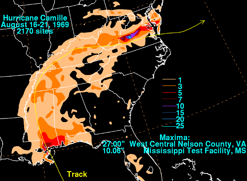
the heaviest rains ever recorded in Virginia from a tropical cyclone occurred in Nelson County in 1969, when Hurricane Camille was slowed by the Blue Ridge
Source: National Weather Service, Hurricane Camille - August 16-21, 1969
Weather patterns, including strong storms such as hurricanes, totally ignore political boundaries. Statistics for a statewide average obscure local patterns and storm impact. Hurricane Floyd dumped 17 inches of rain on Williamsburg on September 16, 1999, but the city of Roanoke received just 1 inch of rain that day.
Political boundaries do affect water management. Roanoke kept its water restrictions in place after September 16, 1999, since the Carvins Cove reservoir was still 25 feet below the spillway. Roanoke County's Spring Hollow Reservoir near Salem, just a few miles away from the city reservoir at Carvins Cove, received enough runoff from its watershed to supply sufficient water all summer for county residents. (Since then, the two jurisdictions have joined the Western Virginia Water Authority and water operations are synchronized.)
Based on the averages since 1885, it would appear Virginia is getting hotter and wetter. Temperature and rainfall averages increase slowly. As global warming adds more heat into the atmosphere and ocean, the increasing intensity of storms and wildfires is causing a fast increase in insurance coverage costs.
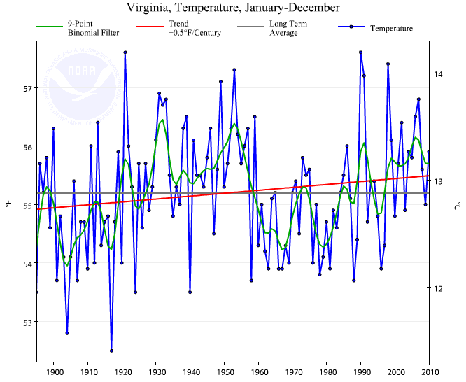
trend of average annual temperature in Virginia, 1895-2010
(red line indicates average temperature is increasing by 0.5°F per century)
Source: National Oceanic and Atmospheric Administration/National Climatic Data Center Temperature, Precipitation, and Drought Time Series
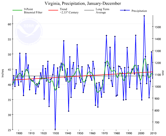
trend of average annual precipitation in Virginia, 1895-2010
(red line indicates precipitation is increasing over 2" per century)
Source: National Oceanic and Atmospheric Administration/National Climatic Data Center Temperature, Precipitation, and Drought Time Series
Key factors that shape Virginia's climate, aside from global weather patterns and latitude, include:
Water heats and cools slower than dry land. Because Hampton Roads is adjacent to the Atlantic Ocean and Chesapeake Bay, it has a more moderate climate than inland cities. Norfolk has less of a temperature range than Bristol, 350 miles west of the Atlantic Ocean. The high temperatures in the summer are higher in Bristol, and the low temperatures in the winter are lower in Bristol.
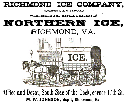
in the 1800's, ships transported ice from northern ports for sale to customers in Richmond
Source: "The Chesapeake & Ohio Railway Directory, Containing an Illustrated History and Description of the Road," Richmond Ice Company (p.476)
The minimum temperatures in November-March show how Hampton Roads stays warmer, thanks to the mitigating impact of the water:
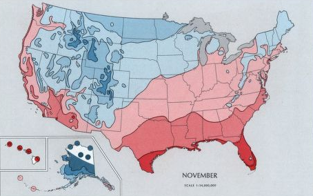
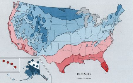
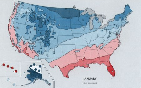

the minimum temperature in November-March show how Hampton Roads stays warmer, thanks to the mitigating impact of the nearby water
Source: Library of Congress, "The national atlas of the United States of America," Monthly Minimum Temperature
Virginia has a "temperate" climate. According to the climate classification system developed by Wladimir Koppen and refined by Glen Trewartha, Virginia's climate has a "mild mid-latitude" climate, and is in the subcategory of "Humid subtropical." It is coded "Cfa" on the Koppen classification system because the climate is mild, with no dry season and a hot summer.
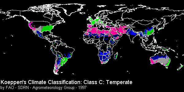
Source: United Nations Food and Agricultural Organization (FAO), New gridded maps of Köppen's climate classification
The Food and Agricultural Organization map shows other countries where the average temperature of the coldest month is <18°C and >-3°C, and the average temperature of warmest month exceeds 10°C. The green zones are places that have at least 30 millimeters of precipitation in the driest month, so the vegetation in those places will be comparable to Virginia.
The sub-tropical part is easy to understand - because we get frosts, we're not tropical. However, if you've ever been in Virginia through a summer, you know it's not the heat, it's the humidity that makes the summers "sticky." Warm temperatures with high relative humidity make it difficult for moisture to evaporate from the skin.
Humidity is what people in Tidewater complain about most often in the summer. East of I-95, the Potomac/Rappahannock/York/James rivers and their tributaries drain to the Chesapeake Bay, providing plenty of water to evaporate in the summer sunshine. Before air conditioning appeared in the 1930's, the best way for Virginians to escape the heat was to retreat to mountain resorts.
Highland County's name reflects its elevation. Because cooler air holds less moisture, a human body can cool off easier through evaporation.
When people in Arizona say "it doesn't feel like 100 degrees, it's so dry out here," they are referring to the ability of evaporation to cool off a body. The same cooling effect is available in the mountains of Virginia. Until the 1900's, Tidewater residents traveled to the resorts at Mountain Lake, The Homestead, White Sulfur Springs, and other higher-elevation, lower-humidity vacation spots with ceiling fans.
In contrast, the modern summer vacation destination of many summer vacationers from Richmond is a cottage at Virginia Beach or along a Tidewater river (saying they are going to the "riv-ah"). Much of Virginia Beach's modern popularity reflects the ubiquitous availability of air conditioning in stores, movie theaters, and homes.
The New River Valley in Virginia is attracting retirees due in part to its climate. Northern residents who retired and moved from the Snow Belt to Florida are returning to a place with seasons. The retirees may not want to return all the way back to harsh winters, however, so they choose to settle in an area that is both north of Florida and higher in elevation. Those who settle in places like Asheville (North Carolina), Blacksburg, and Roanoke are known as "halfbacks" who made it only halfway back to their old home.
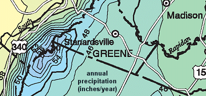
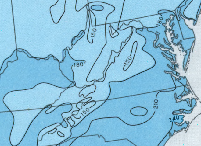
"isohyets" (lines of equal precipitation) showing effect of
Blue Ridge Mountains on precipitation patterns
Jimmy Buffet has suggested that we can change our attitude by changing our latitude. The reverse is also true - our personal comfort zone can be based on maintaining the same latitude.
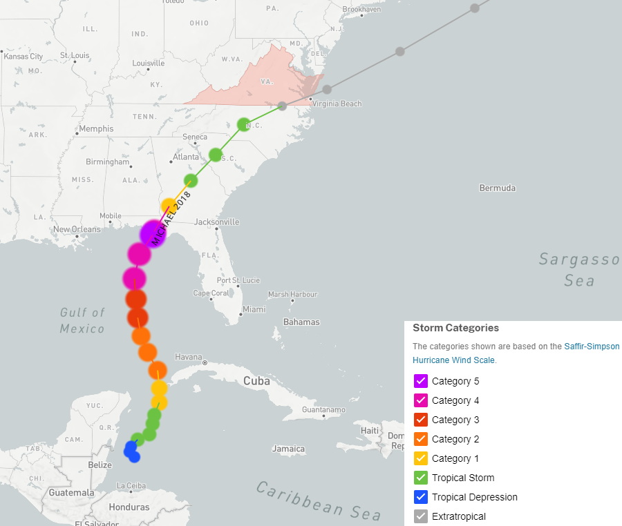
hurricanes lose intensity as they move north, away from the heat at tropical latitudes
Source: National Oceanic and Atmospheric Administration (NOAA), Historical Hurricane Tracks
When the state's economic development agents encourage companies from Korea and Japan to open facilities in Virginia, they describe how the company's managers can deal with the cultural differences - and one positive factor is that Virginia has a similar climate to "home."
Latitude alone does not determine the weather patterns or ecology of a place. Follow the original Virginia/Carolina border (the 36° parallel of latitude) eastward across the Atlantic Ocean. England is far north of its old colony of Virginia. Sailors who settled the first two English colonies in North America sailed from Plymouth (north of the 50th parallel of longitude) and London (north of the 51st parallel of longitude) to Jamestown, just north of 3736° latitude.
The early English colonists did not sail due west to Virginia. If they had tried sailing due west in a straight line, they would have ended up in Canada, north of the mouth of the St. Lawrence River in Labrador and Newfoundland - where the Vikings first settled in North America.
The English colonists first sailed south towards the Equator, then they turned west.
The 36° parallel, the southern border of Virginia after Carolina was chartered initially, crosses through the Straights of Gibraltar, south of Spain where modern Clementine oranges are harvested each September. The parallel goes across Malta, south of Italy, Greece and Turkey, and through Tehran in Iran and Mosul in Iraq. It touches the northern border of Tibet, crosses China between Shanghai and Beijing, then goes across South Korea before reaching Tokyo. In California, that parallel is just south of Silicon Valley.
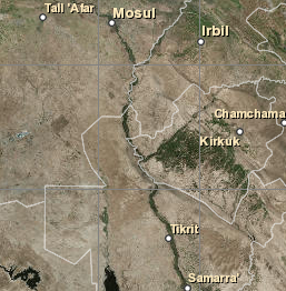
What's at latitude 36° north, longitude 45° east?
Source: ESR!, ArcGIS Online
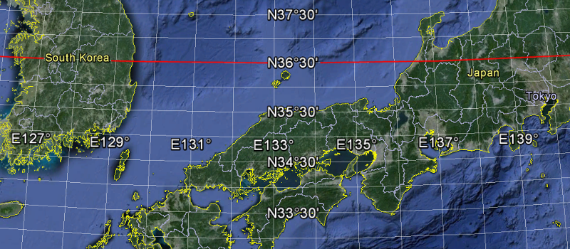
the 36° 30' latitude of Virginia's southern border, in Asia
Source: Google Earth
Virginia gets frosts and snowstorms from the cold polar air masses, especially in January. The shortest days of winter are in December, but the coldest days come weeks later in January. There is a lag time. The landmass of Virginia keeps cooling even after the December 21/22 winter solstice, when days start to get longer. For several more weeks after the winter solstice, Virginia radiates heat faster than the short winter days can re-heat the land... one reason February can feel like the longest month of the year, despite having the shortest number of days.
Hampton Roads has a longer growing season, with 240 days between the last freeze in Spring and the first freeze in Fall, thanks to the moderating impact of large water bodies in the region
Source: Library of Congress, "The national atlas of the United States of America," Freeze-Free Period
Climate shapes vegetation. Colonists in Eastern North America were disappointed when they tried to grow crops common to Western Europe at 36° latitude. Citrus and silkworms thrived at that latitude as Western Europe, but the Virginia winters were too harsh due to the winter frosts. When Europeans reached Southern California, they found a parallel region with a "Mediterranean" climate similar to Spain - and where orange and olive groves are successful.
occasionally, weather reports suggest a simple relationship between warm lower latitudes and cooler higher latitudes
Thomas Jefferson recorded in his Garden Book that the vegetation in May, 1774 was growing as if the winter was over until a late frost arrived:5

Atlantic Ocean and warm Gulf Stream keeps wintertime temperatures warmer in southeastern Virginia
Source: National Oceanic and Atmospheric Administration/National Ocean Service, The Gulf Stream Current
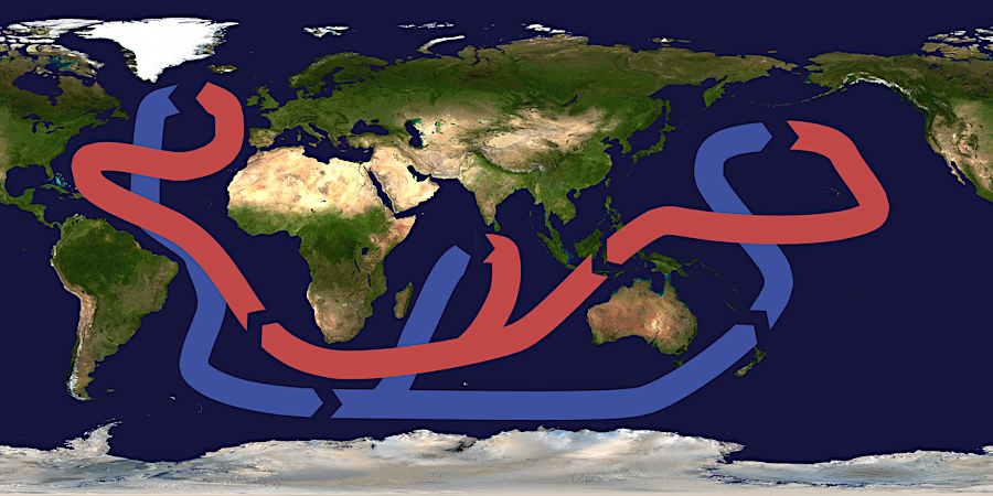
the Atlantic Meridional Overturning Circulation (AMOC) moves warm water (red) from the Equator towards the poles, and recirculates colder/saltier water (blue) at depth
Source: Wikipedia, Heinrich event
Tables of statistics, such as the Historical Climate Summaries for Virginia, can be useful even though hard to read. The monthly climate summary for Fredericksburg, using data from 1930-1997, shows how precipitation (including snow) and temperature normally vary between November and February:
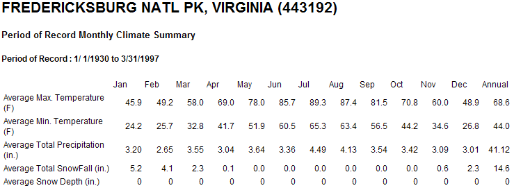
Source: Southeast Regional Climate Center, Fredericksburg National Park
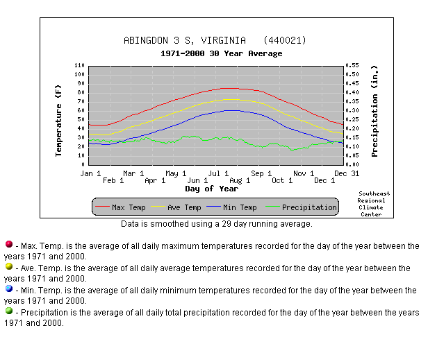
Graphs to visualize the data can show key points easily. A brief glance at the graphic below shows that the temperature in Abingdon rises and falls in a predictable pattern each year, while the precipitation pattern is not so consistent:
The climate normals over the last 30 years will vary from the averages established by records over the last century, back to 1895 in some cases. A comparison of today's with the climate of the Pleistocene 18,000 years ago (when Pennsylvania was half-buried by ice and there was no Chesapeake Bay), or at the end of the Paleozoic 250 million years ago (when massive coal deposits formed), shows than climate change over geologic time has been dramatic.
The 30-year normals reflect just the patterns of the last 30 years. Climate changes, though not as rapidly as the weather. The averages of the last 30 years may include warmer temperatures, higher moisture, etc. than averages calculated using all the data collected for over 100 years since 1895, but the patterns are consistent.
Perhaps surprisingly, however, the warming climate has not generated an increase in the number of days with temperatures exceeding 90°F. A common perception that "days are getting hotter" may be true on average throughout the year, but is not reflected in the data for the number of 90°F+ days:6
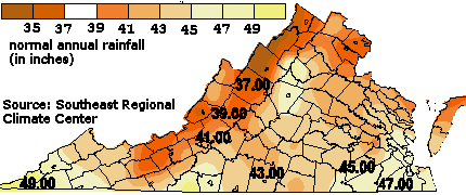 average normal rainfall, 1971-1990 |
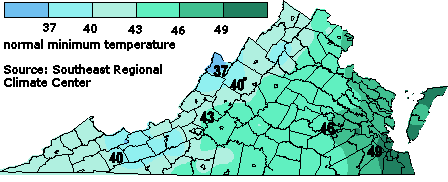 average normal minimum temperature, 1971-1990 |
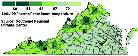 average normal maximum temperature, 1971-1990 |
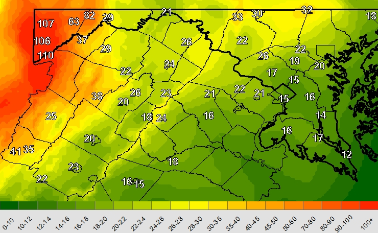
 Mean Temperature - August (note the location of the "hot spots" and "cool places") |
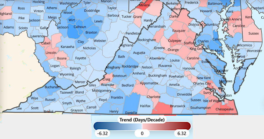
over the last 40 years, the number of days in Virginia with temperatures exceeding 90 degrees has dropped (as shown in blue) in the majority of counties
Source: Urban Sustainability Directors Network, Climate and Hazard Mitigation Planning (CHaMP) Tool
There is a pattern to the temperature differences in Virginia. Not every place has the same weather, and not every place in Virginia has the same climate.
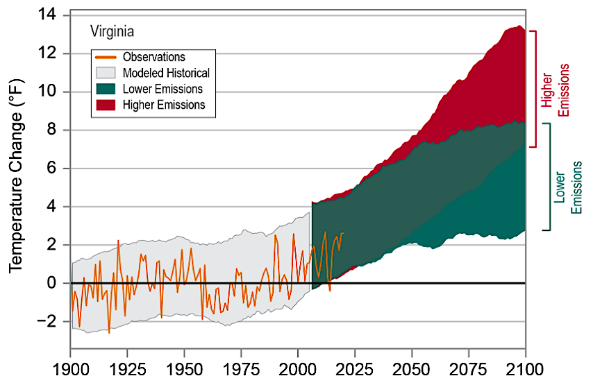
observed and projected temperature change in Virginia
Source: National Oceanic and Atmospheric Administration (NOAA), Climate Summary - Virginia
On the map below, the temperatures in Bath/Highland counties are different from temperatures in Richmond/Norfolk. The vegetation in the mountains is different from vegetation on the Coastal Plain because the highest/lowest temperatures, average temperatures, and snow/rainfall patterns are different. The growing season between the last frost of the Spring and the first frost of the Fall constrains what plants can grow in different places. When vegetation changes, the animals change.
The cool summer temperatures show why the rich Virginians went to the mountain springs and resorts during August in the 1800's before the invention of air conditioning - and why they did not go to the mountains in the winter before skiing became a sport.
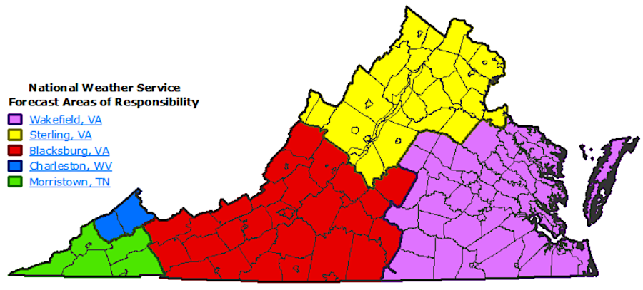
six different National Weather Service offices provide weather forecasts for places in Virginia
Source: National Weather Service, Virginia NWS Office County Breakup
Changes in the climate reflect changes in the amount of carbon dioxide in the atmosphere. Global warming is triggered by the greenhouse effect, with higher percentages of CO2 generated by the use of fossil fuels to supply energy since the beginnings of the Industrial Revolution in the late 1700's.
The increase in carbon dioxide does not ensure that every day will be warm, however. Those who dispute the science of climate change, and even those who acknowledge the cause and effect of burning fossil fuels, may conflate short-term cold weather and snowstorms with long-term changes in average climate patterns. Stephen Colbert supplied a succinct response to that approach with a tweet in 2014:7
Average Temperatures in Virginia
Source: SERCC, Historical Climate Summaries and Normals for the Southeast
the Atlantic Ocean and Chesapeake Bay hold heat, lengthening the growing season between last frost in Spring and first frost in Fall
Source: Virginia Cooperative Extension, Vegetable Planting Guide and Recommended Planting Dates
Individuals as well as government agencies, corporations, and non-government organizations can take action to minimize the increasing levels of greenhouse gas emissions. One option is to offset carbon emissions by the use of Renewable Energy Certificates (RECs). Each REC is a legal instrument certifying the production of 1 megawatt-hour (MWh) of renewable electricity generation.
RECs are sold most commonly by corporations generating electricity at solar facilities. That income helps justify the investment in new renewable generation capacity. RECs are purchased typically by corporations in states that require using a certain percentage of renewable energy. Some corporations may be able to build their own solar facilities or generate enough electricity by other renewable means to meet the state requirements, but other companies purchase RECs in order to comply.8
Another option is to offset emissions by sequestering carbon. In addition to natural sources of carbon dioxide (CO2) and methane (CH4), there are natural "sinks" which convert those gases into a different form that does not increase global warming. About 100 billion tons of carbon dioxide goes through this natural cycle every year.9
There are various techniques to convert CO2into a different form. Spreading iron filings in the ocean can increase the amount of dissolved carbon dioxide that naturally becomes a solid mineral and sinks to the ocean floor. Expensive machinery can perform Direct Air Capture (DAC), a carbon-negative technology.
The simplest option for sequestering carbon is to plant vegetation. Photosynthesis will extract CO2 from the atmosphere and create carbohydrates in plant tissue.
Some companies such as Verra certify offset credits, based on the claim that they have protected existing "sustainable" forests/grasslands or planted new vegetation. Trees sequester carbon in wood; grasses sequester carbon in their roots. Protecting an existing forest/grassland ensures the vegetation will continue to sequester carbon, assuming a fire does not quickly convert the plant tissue into smoke.
Revenue from the sale of offset credits is used to purchase tropical rainforests and prevent deforestation. However, some claims of avoided deforestation are questionable. "Phantom credits" may be closer to a financial greenwashing exercise than a solution for global warming.10
In addition, protecting existing vegetation does not extract any additional CO2 from the atmosphere beyond the natural cycle. Eliminating sources, such as closing electricity generating plants burning fossil fuels and replacing them with facilities generating electricity from wind and solar, creates a net reduction in emissions. Weatherizing homes and replacing use of natural gas to renewable energy also creates a net reduction in emissions.
Increasing the number of trees on earth, converting grasslands with low sequestration rates into forests with greater sequestration rates, could have an impact:11
The claim that an average tree sequesters about 50 pounds of carbon dioxide per year may be excessively high. OneTreePlanted calculated that if 400 trees were planted per acre (1,000 trees per hectare), on average for the first 20 years of growth each tree would remove 22 pounds (10 kilograms) of CO2 from the atmosphere.12
To deal with seasonal changes in temperature and water availability, animals like bears and groundhogs hibernate/estivate underground or in sheltered places. Insects pupate, or overwinter as eggs. Birds migrate south.
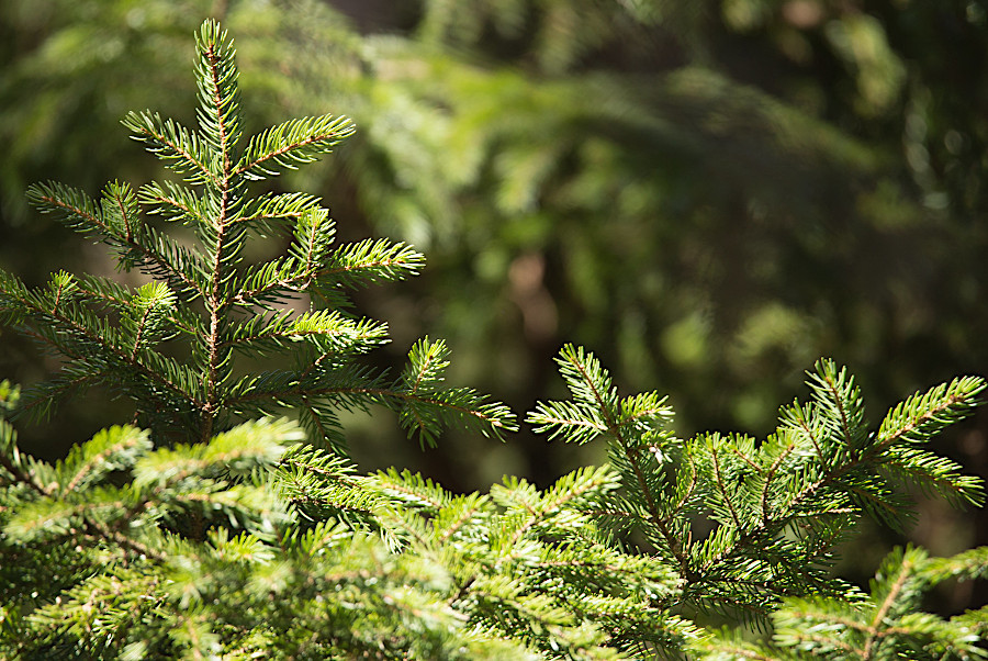
Deciduous trees drop their leaves and protect next year's growth with bud scales. Conifers close their stomata more often to avoid dehydration in the cold, dry air. Non-woody herbs ("forbs") and grasses go dormant, or die in the Fall after spreading seeds that will grow in the Spring.
Species are always adapting, but many plants and animals appear unable to adjust to the speed of the current climate change. Some species survived the last 18,000 year of global warming by moving to higher elevations, but in Virginia the relatively cool conditions in the Blue Ridge are disappearing. Other species are migrating to higher latitudes now, so local populations in Virginia are being extirpated.
Red spruce and Fraser fir, which today form "sky island" forests, are impacted by the reduction in high-elevation clouds as well as by warmer days and nights. Sunnier days reduce the condensation that provides about one-third of the water to the trees, and in drier conditions trees struggle to move water from roots to the needles at the top and at tips of branches. Lack of water reduce resin production, enabling beetles and other pests to damage trees more extensively.
global warming could cause "sky island" forests with red spruce to disappear from Virginia's high elevations
Source: Shenandoah National Park, Red Spruce says "Hello"
Plants and animals have evolved to rely upon the timing of cyclical and seasonal biological events ("phenology"). Spring ephemerals such as bluebells flower beneath trees that have no leaves. The sunlight reaching the ground allows photosynthesis to occur. Once the leaves emerge and intercept the sunlight, spring ephemerals go to seed and wait another 10-11 months to emerge again.
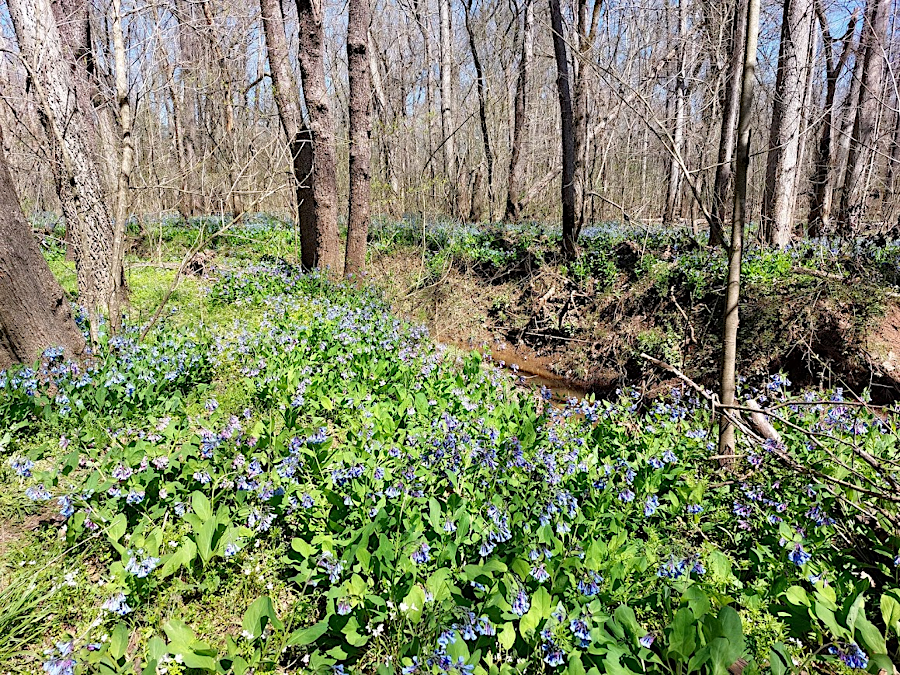
the Bluebell Festival is scheduled in late March/early April at Merrimac Farm Wildlife Management Area, and two weeks later all the flowers are gone
As Spring starts, balls of seeds that hung on sycamore trees over the winter finally break apart. Sycamores scatter seeds at roughly the same time that annual high water periods recede in stream channels, exposing mud flat habitat that is suitable for sycamore sprouts.
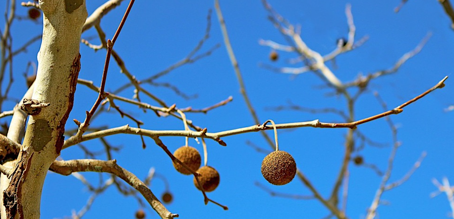
winds distribute sycamore seeds when mud flats appear in the Spring
Source: Pixabay, a bare tree with fruit hanging from its branches
Seeds of multiple species sprout after the last day of frost. Flowers appear at approximately the same time as pollinators emerge or arrive. Birds migrate back to Virginia, build nests, and lay eggs when their food sources become most available.
The slow process of evolutionary change is being exceeded by the faster pace of a warming planet:13
For example, two chickadees need to gather 6,000-9,000 caterpillars to feed their clutch of young birds in the nest. If the warming climate causes insects to merge and morph into adult forms earlier than normal, chickadee eggs may hatch too late for the parents to collect the essential food source. Young chickadees need energy-rich caterpillars, not seeds, berries, or nectar that might still be readily available, in order to survive.14

a pair of chickadees collect 6,000-9,000 caterpillars to feed one clutch of nestlings
Source: Wikipedia
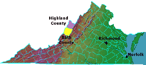
Bath and Highland counties, and cities of Richmond and Norfolk
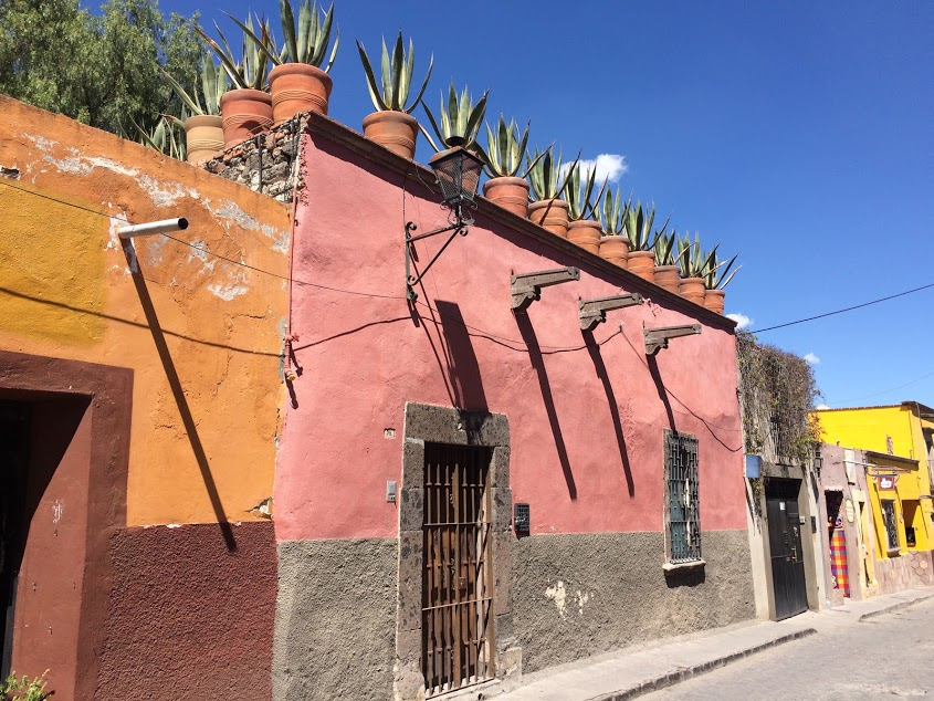
gutters and downspouts are not the same everywhere - in San Miguelle de Allende, Mexico, runoff is directed to the street over the heads of pedestrians on the sidewalk
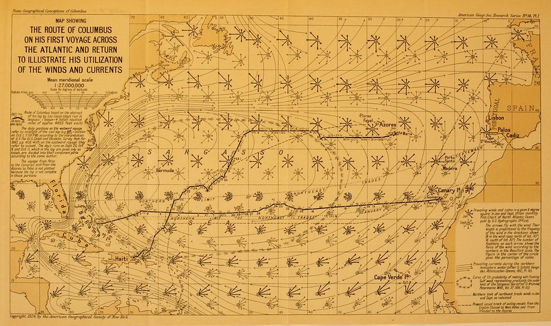
in 1492, Columbus knew to sail south to catch the trade winds near the 30° latitude caused by descending winds of the Hadley cell and the Coriolis effect
Source: Open Library, The route of Columbus on his first voyage as evidence of his knowledge of the winds and currents of the Atlantic
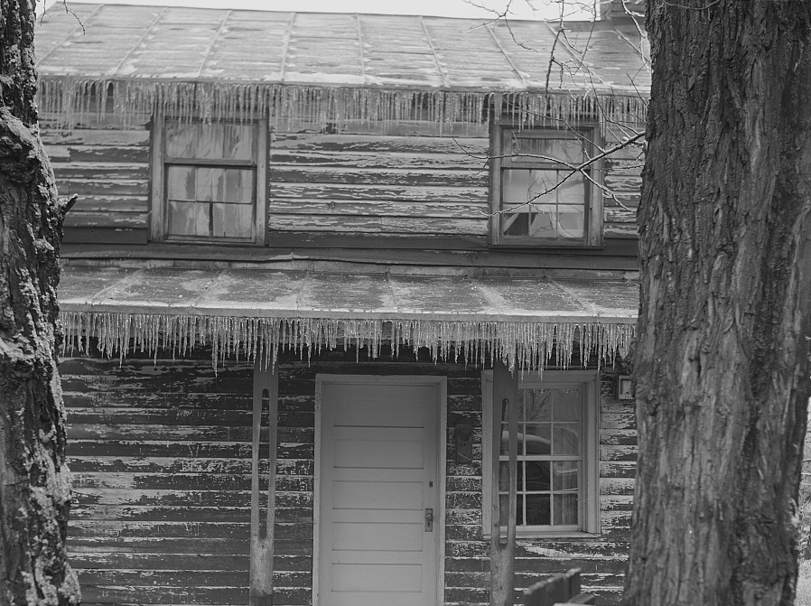
icicles in Harrisonburg
Source: Library of Congress, Harrisonburg, Virginia
the Mean Daily Average Temperature on Virginia's coastline differs from the average temperature in the mountains along the western edge
Source: National Oceanic and Atmospheric Administration (NOAA), Climate Atlas of the United States
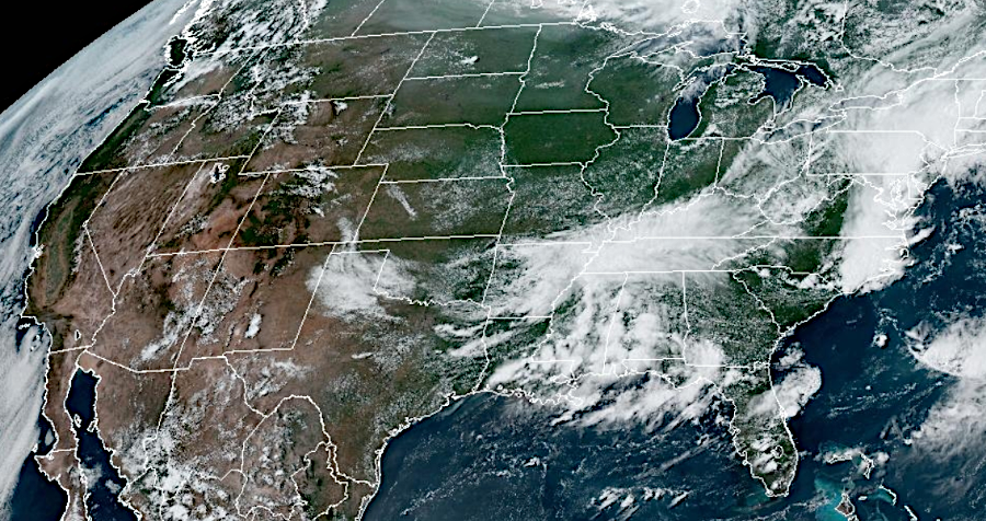
radar imagery of a typical cold front in July, moving eastward to Virginia
Source: Cooperative Institute for Research in the Atmosphere (CIRA) and National Oceanic and Atmospheric Administration (NOAA), GOES-East CONUS - GeoColor (July 9, 2023)
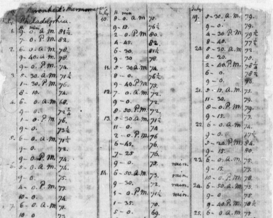
Thomas Jefferson recorded temperature throughout the day when writing the Declaration of Independence in Philadelphia, and for many years at Monticello
Source: Library of Congress, Weather Record, 1776-1818
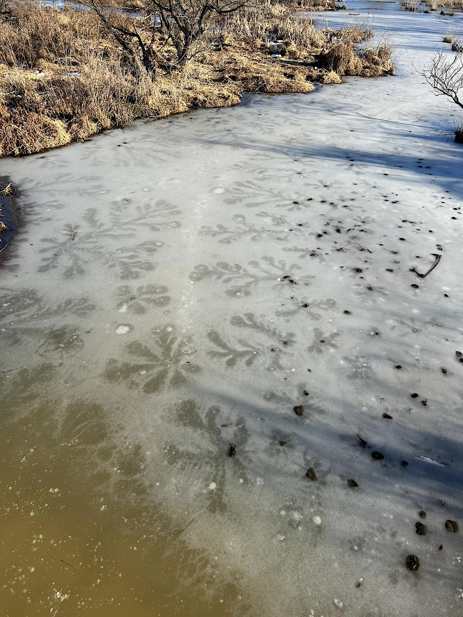
lake stars/ice stars, rare in Virginia, formed on the ice at the Neabsco Boardwalk in January 2025 when water oozed up through a hole in the ice and spread slightly before freezing
Source: Prince William County Department of Parks and Recreation, Facebook post (January 29, 2025)