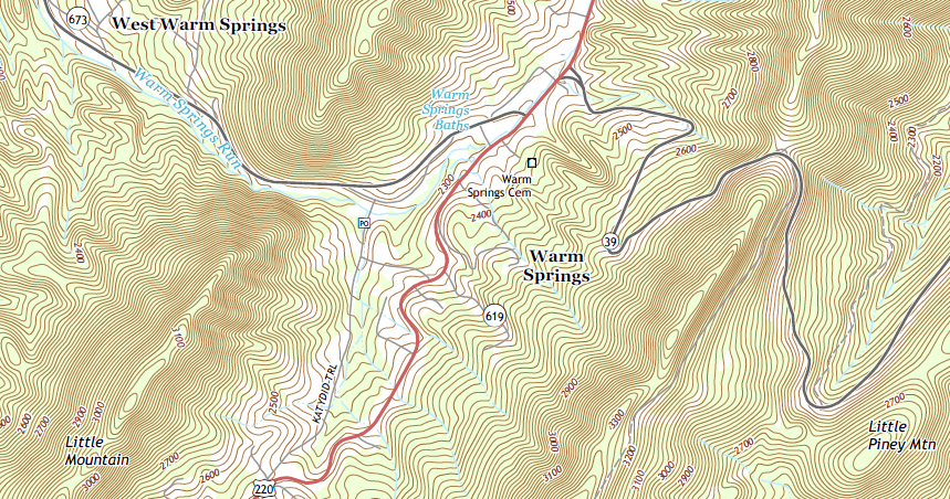
topographic map showing contour lines near Warm Springs in Bath County (contour interval: 20 feet)
Source: US Geological Survey (USGS), Warm Springs, VA 7.5-minute topographical map (2016)
NOTE: if you are a geography major, this material will be "old hat" to you. If your background is in another discipline, this might provide a useful refresher.
topographic map showing contour lines near Warm Springs in Bath County (contour interval: 20 feet)
Source: US Geological Survey (USGS), Warm Springs, VA 7.5-minute topographical map (2016)
The DeLorme Atlas and Gazetteer, like the 1:24,000 quadrangle (quad) maps of USGS, provides "topographic" (topo) maps. Such maps show the elevation of mountains and valleys with contour lines, with the elevation differences represented by light brown lines illustrating the height of the land above sea level.
Once you get the hang of it, you can see how the lines display the location of hills and valleys. Note that the contour intervals in the DeLorme Atlas and Gazetteer are in meters. Convert the metric units to traditional English units, and you'll discover that 40 meters is roughly 131 feet.
The legend on the inside cover of the DeLorme Atlas and Gazetteer explains the colors and categories of information displayed on the map. The legend is the equivalent of a secret decoder ring for interpreting the lines and colors on the paper. You need good eyes to distinguish the symbols on the maps for pipelines vs. powerlines, or woodland vs. orchard - but get out your reading glasses, flip through a few maps, and get to know how to interpret the information.
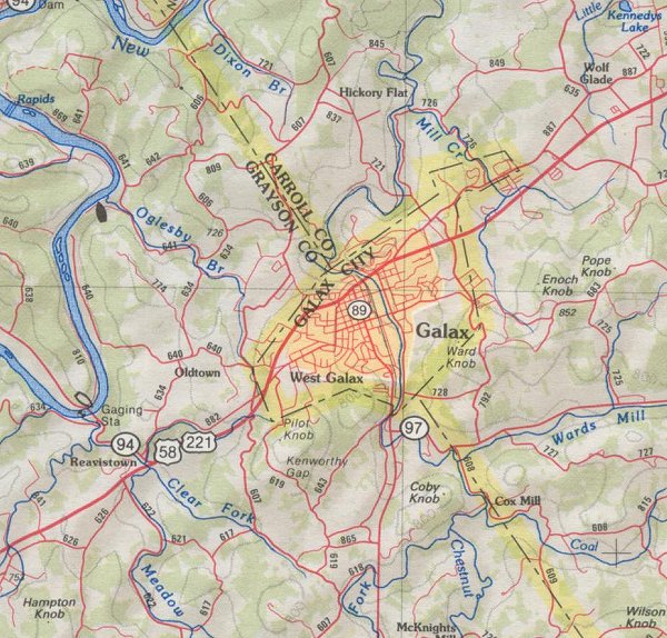 urban areas are portrayed in the atlas as orange, streams are blue, roads are red, forested areas are green, open fields are white, and county/city boundaries are dashed black lines highlighted in yellow - but what are the squiggly brown lines? |
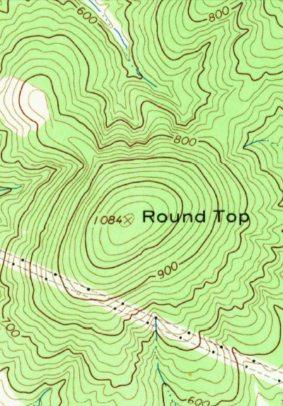 USGS topo map showing contour lines for Round Top mountain in Albemarle County near Charlottesville |
Not all maps have contour lines - the Virginia Department of Transportation (VDOT) highway map uses shading to show elevation, while a watershed map may totally omit the topographic layer of information. Most of the topographic maps we will use in this class will include other lines to show the location of roads, rivers, and urbanized areas - but by definition, a "topo" map will always show contours of elevation.
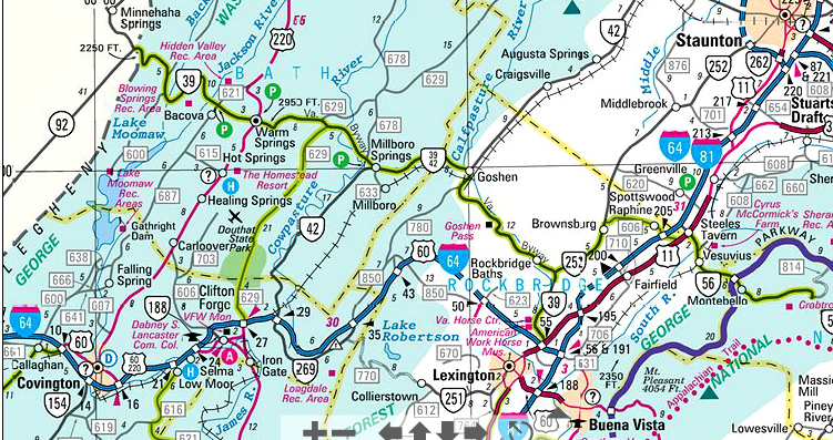
highway maps would be unreadable if they showed elevation through contour lines, so look for shading instead
Source: Virginia Department of Transportation (VDOT), State Transportation Map (2016)

Compare the topographic map and the aerial photo of Cumberland Gap, at the far southwest corner of Virginia. That gap offered the easiest path through the Allegheny Front, in the 1700's. Daniel Boone and his axemen cut the Wilderness Road through the low spot in the mountain barrier in 1775, and settlers poured into Kentucky. The Native Americans in the area resisted, and Kentucky becane a "dark and bloody ground" as Cherokee chief Dragging Canoe had predicted.
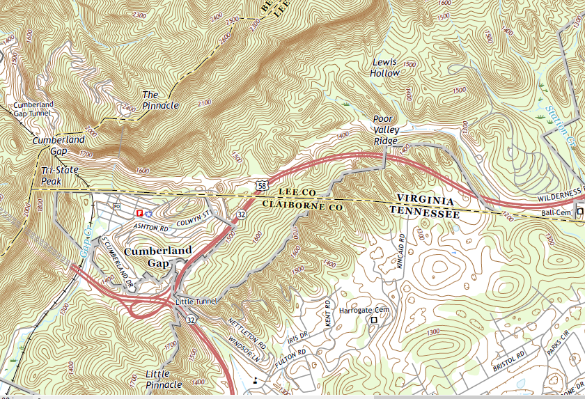
topographic map of Cumberland Gap
Source: US Geological Survey (USGS), Middlesboro South, KY-TN-VA 7.5-minute topographic map
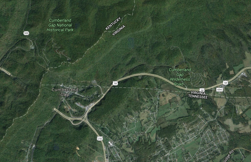
in the topographic map, did you notice the highway now goes underneath Cumberland Gap in a tunnel?
Source: Google Maps
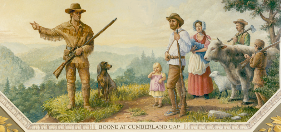
in 1775, the land speculators of the Transylvania Company paid Daniel Boone to blaze a path westward from Cumberland Gap into Kentucky's Bluegrass Region
Source: Architect of the Capitol, Boone at Cumberland Gap
If you use a radar sensor, you can see the mountains on an image without the clutter of all those contour lines drawn by a cartographer (or a computer...). Photos and radar images are not topographic maps, but they do allow us to "see" the mountains. Can you visualize topographic lines in your head, even when they are not displayed on a photo?
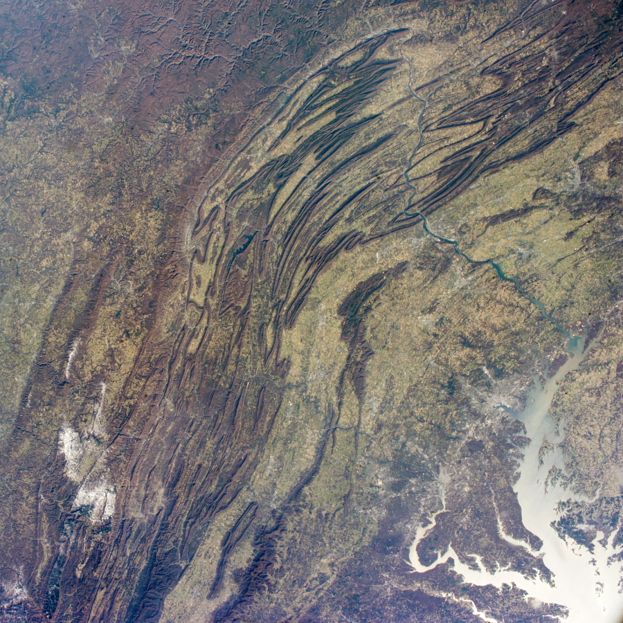
mountain topography - can you spot Massanutten Mountain, west of the Potomac River?
Source: US Geological Survey (USGS) Earth Observatory, Appalachian Mountains
CAUTION: maps are printed in different scales; some maps measure elevation in meters rather than feet. One meter is roughly 3.3 feet, so 10 meters = about 33 feet, or roughly 10 yards. The scale of the DeLorme Atlas and Gazetteer maps is identified on the bottom of each page. The contour lines are 40 meters apart on the maps in that atlas, compared to 20 feet apart on the 1:24,000 scale USGS topo maps.
SECOND CAUTION: Virginians were not always creative when choosing place names; they repeated themselves, and recycled names that had been used in other places. There is more than one Blacksburg, and many "Little River" streams in Virginia. There is more than one mountain in Virginia named after cobblers, or people named Cobbler.
There is a Cobbler Mountain in Bath County:
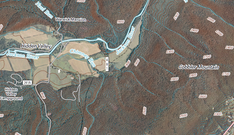
Cobbler Mountain near Warm Springs in Bath County
Source: US Geological Survey (USGS), Warm Springs, VA 7.5-minute topographical map (2016)
There is a Big Cobbler Mountain, and a Little Cobbler Mountain, in Fauquier County.
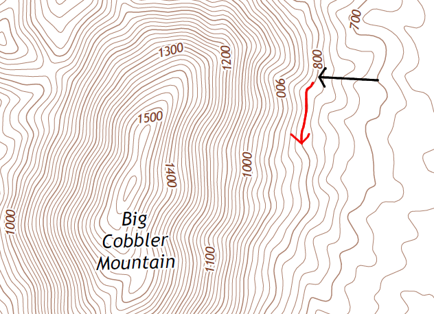
If you were walked up Big Cobbler Mountain and followed the black arrow, you would be walking uphill from 700 feet to 800 feet above sea level. If you chose to walk around the mountain on a path that followed the contour lines, you would follow the red arrow and be walking at the same elevation - neither uphill nor downhill. You might get tired stepping over boulders and fallen trees, but you won't be walking uphill or downhill. When you follow a contour line, you are walking at a constant elevation.
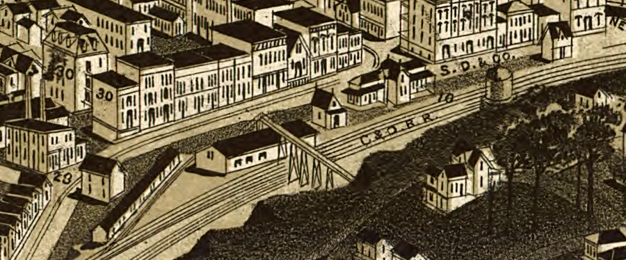
Flat trails are easy for hikers - and essential for railroads. When railroads build their lines, the surveyors identify the contour lines. Rail construction is designed wherever possible to avoid going uphill or downhill.
Locomotives with smooth steel wheels on smooth steel rails can haul massive loads on level tracks, but those locomotives lose much of their power on an uphill grade where the tracks rise as little as 1" in elevation for every 100 feet of horizontal distance. Braking a multi-ton train on a downhill slope is also a major challenge. The railroad depot in downtown Staunton was located at a low point in the track, requiring trains to climb whether headed east or west. That station was destroyed in 1890, after a Chesapeake and Ohio (C&O) train lost its brakes and a car plowed right through the building.
|
Bicyclists tend to be especially conscious of contours. The Washington and Old Dominion (W&OD) bike path in Northern Virginia is a flat trail that was built originally for a railroad to connect Alexandria with the coal fields of Hampshire County (in what is now West Virginia).
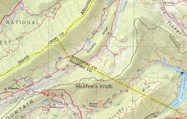
The tracks were never extended west of Purcellville into the Shenandoah Valley and then further west into the coal fields. It was too expensive to create a flat route through the Blue Ridge in western Loudoun County by carving a tunnel or a massive trench through the mountains. Look at any map of the western part of Virginia, and train your eyes and brain to recognize ridges vs. valleys. Then compare maps of the southwestern corner of Virginia with maps of the southeastern corner. It should be obvious that the Eastern Shore is flat, while Lee County has valleys and mountains. Wonder which area has waterfalls? Surfing might be better in Virginia Beach, but the tallest mountain there is an old solid waste landfill known as Mt. Trashmore. Where the contour lines are printed very close to each other, you are looking at a steep hillside. In the image to the right, there's a relatively flat plateau to the west of Trimble Mountain (in this case, "north" is to the top and "west" is towards the left side of the map). If you bicycled on Forest Road 95, you'd stay on relatively level ground until you get near Todd Lake. However, if you took your mountain bike from the road up to the top of Elkhorn Mountain, you'd have a steeper climb - and a rather exiting descent, compared to road biking. Hikers on the Appalachian Train are also conscious of contours. As described in the legend on the inside cover - you really are getting out your paper copy of the atlas and checking these things as we go, right? - the DeLorme Atlas and Gazetteer maps portray the trail as a series of black circles. As shown on the map below, near Roanoke the trail stays relatively level on Catawba and Tinker Mountains. There is just a slight diversion to climb McAfee's Knob north of Route 311, before you reach the Botetourt County line. |
|
In addition to getting familiar with the legend for the DeLorme maps, you should also get savvy about standard USGS topographic symbols - see Topographic Map Symbols if these are not already familiar to you.
Feeling confident? Test yourself - use the index in the Virginia Atlas and Gazetteer to find Glasgow, and then trace the James River eastward as it flows downhill past Lynchburg and Richmond to the Chesapeake Bay at Norfolk. Compare the topographic contours on maps #18/19 with maps #34/35.