At the end of this section, you will be able to:
- identify the corners of Virginia
- describe how three charters established different boundaries of Virginia
- describe how the Maryland, District of Columbia, and Pennsylvania boundaries have evolved over time, and some impacts from the changing locations of those boundaries
- explain why Maryland "owns" the entire Potomac River, not just half
- describe how Accomack County have been shaped through political rivalries and sea level rise
- identify the boundary between state/Federal control in the Atlantic Ocean, and the role of the state in leasing the Outer Continental Shelf for wind turbines and oil and gas platforms
- locate places in Virginia with the USGS Geographic Name Information System (GNIS), and trace a river upstream in the Virginia Atlas and Gazetteer, recognizing their differences in map scales
- use online resources at the Library of Congress to explore Northern Virginia on the historic map of Virginia produced by Joshua Fry and Peter Jefferson in 1755
|
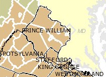
Political boundaries change - notice the original Prince William County
boundaries in 1732, before Fairfax, Fauquier, Loudoun, and Arlington counties were created
Source: Newman Library - Atlas of Historical County Boundaries
|