Rivers and Watersheds of Virginia

At the end of this section, you will be able to:
  • list the major watersheds of Virginia, draw a rough outline of them on a map of the state, and identify the direction in which the major Virginia rivers flow
  • explain the diference between "watersheds" and "divides," and draw the Eastern Continental Divide on a map of Virginia
  • locate the "headwaters" vs. "mouth" of Virginia rivers
  • distinguish between the Chesapeake Bay shoreline and the Chesapeake Bay watershed
  • explain how stream piracy alters watershed boundaries
  • explain why Virginia has only two natural lakes, and describe the unique characteristics of each one
  • identify the location of Dragon Run, and explain why efforts are underway to protect it from development
  • explain why so many Virginians drink what was once sewage
  • use the EPA "Surf Your Watershed" site to obtain specific information regarding individual watersheds

Headwaters of the Potomac River, near the Fairfax Stone in West Virginia
headwaters of the Potomac River, near the Fairfax Stone in West Virginia
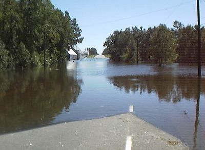
floodwaters over US 460 after Hurricane Floyd (Sussex County)
Source: National Weather Service, Floyd '99 at NWS Wakefield, VA


Week 3: Rivers and Watersheds of Virginia
Geography of Virginia