Assignments for Class 3: Rivers and Watersheds of Virginia
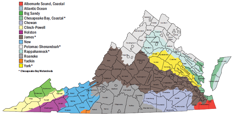
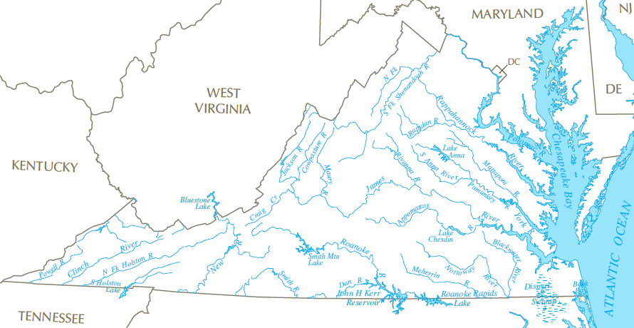
Virginia watersheds (do any Virginia rivers drain into Tennessee, Kentucky, or West Virginia?)
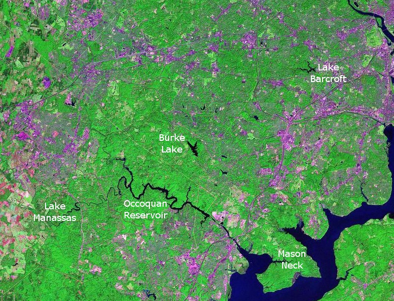
southern Fairfax County/northern Prince William County, from I-66 to Lake Montclair
(can you spot Lake Barcroft, Burke Lake, Occoquan Reservoir, Lake Manaassas, or Mason Neck? Compare your answers with an image listing those places...)
Source: NASA, Stennis Space Center
- Watershed and Divides (get very clear on the relationship between ridges that separate watersheds and the path of rivers themselves - on a map, watersheds are large areas while rivers are thin blue lines)
many - but not all - streams in southeastern Virginia are tributaries of the Chesapeake Bay
Source: Virginia Department of Conservation and Recreation, River Basins in Virginia
the Yadkin River watershed in Patrick County drains to the Pee Dee River, not to Albemarle Sound or the Chesapeake Bay
Source: Virginia Tech, Restoring Forest Cover to Your Watershed
The three main watersheds in Southwest Virginia drain into the Ohio River, so they are not tributaries to the Chesapeake Bay. Their fourth order USGS HUC code will not start with 02
Even if you are a native Virginian (bless your heart...), you might call it the "Stawn-ton River" instead of the correct "Stan-ton River." How you pronounce place names might reveal you to be a foreigner/alien when you visit some some spots in the state, unles you practice your pronuncification in advance.
"layers" displayed on this map include topography, rivers and waterbodies, and political boundaries - but no roads are displayed
identify the Northern Neck, Middle Peninsula, and Peninsula regions of Virginia, located east of the Fall Line between the Potomac, Rappahannock, York, and James rivers
observe how the divide along the Blue Ridge was used to define natural boundaries for counties, similar to the way the Fairfax Grant's southern edge was based on the Rapidan and Rappahannock Rivers)
Most "wind gaps" in the Blue Ridge may be located where movement along geologic faults cracked the bedrock and facilitated erosion... but it is possible that several more rivers once cut water gaps through the mountains, before stream piracy altered flow patterns. Today, only the Potomac, James, and Roanoke rivers still flow through the Blue Ridge in Virginia.
Rivers in far southwestern Virginia located west of the Eastern Continental Divide will drain to the Gulf of Mexico, not directly to the Atlantic Ocean. (The Eastern Continental Divide is located in three physiographic provinces - clearly the physiographic province boundaries are not based on watershed boundaries...)
Lake Drummond is designated as one of Virginia's Exceptional State Waters; designation prohibits permanent new "point source" pollution sources, or increased discharges from pipes or other point sources, into the protected water
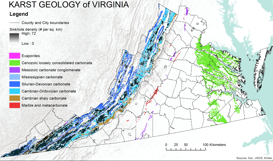
sinkholes might develop in carbonate bedrock deposited on the Coastal Plain when sea levels were higher, but sinkholes are most common west of the Blue Ridge
Source: Virginia Department of Conservation and Recreation, Selected karst features of the northern Valley and Ridge
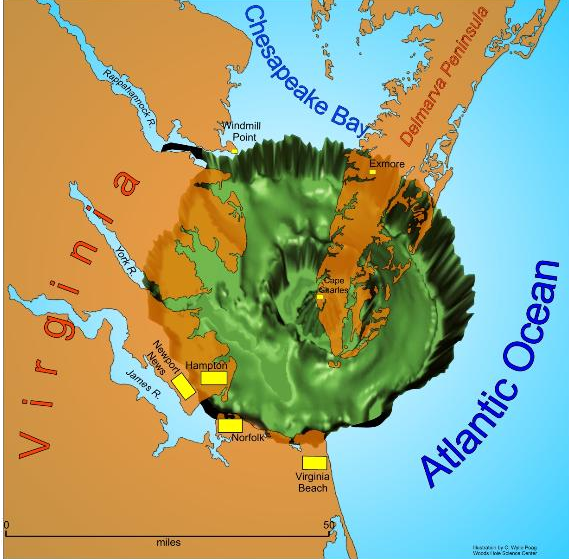
4) The Chesapeake Bay Bolide
Most geological change in Virginia has occurred gradually, one rainstorm/earthquake at a time. Normal rainstorms wash a little sediment towards the Chesapeake Bay or Gulf of Mexico, and that regular erosion reshapes the surface topography of Virginia in a very gradual process. Odds are good that anyone living in Virginia for enough years to get a college degree will experience a hurricane or storm that drops more than 3" of rain in just a day, creating landslides in the mountains, collapsing the banks of small streams to send a slug of sediment downstream, and boosting the profits of NBC-TV (which bought the Weather Channel).
"Singularities" are exceptionally rare, dramatic events that trigger substantial change in just hours. About 35 million years ago near the end of the Eocene epoch, an icy comet or rocky meteor (a "bolide") crashed into the Atlantic Ocean off the Virginia coast.
The bolide blasted out a deep hole, cracking bedrock as much as seven miles down. The splash sent a wave of water inland, a tsunami that may have have washed up to - and even over - the Blue Ridge. (Yeah, that qualifies as a singularity... though 65 million years ago, a larger bolide impacting in the Gulf of Mexico triggered the end of the dinosaurs.)
The sediments carried inland across the Piedmont by that tsunami have long since washed away. Erosion has etched away at the Piedmont, moving it grain by grain to the Coastal Plain. The bolide impacted into the ocean, and 35 million years later the crater is buried underneath 1,500 feet of sediments. The specific site of the impact is now dry land, covered by sandbars and barrier islands as the Delmarva Peninsula developed on top of the impact site.
Virginia changes over time. Most physical changes are gradual, as are most cultural changes. The Supreme Court ordered desegregation of Virginia schools "with all deliberate speed" in 1955. The residue of racial prejudice is still evident in Virginia's housing patterns, socio-economic statistics, and still-segregated churches over 60 years later, but the changes in Virginia society since the days of "Jim Crow" are obvious. The changes in Virginia's topography are also obvious, when examined in geologic time rather than the scale of human lifetimes.
If you are so clumsy that you spill a drink while wandering through downtown Roanoke, will the melting ice end up in the Chesapeake Bay? And did you note the small watershed at the southern corners of Carroll and Patrick counties? It drains into the Yadkin River of North Carolina, then into the Pee Dee River of South Carolina, and ultimately the Atlantic Ocean. Rain can fall east of the Blue Ridge and not run into either the Chesapeake Bay *or* into Albemarle/Pamlico Sound. WARNING: many depictions of Virginia hydrography ignore the Yadkin/Pee Dee watershed.
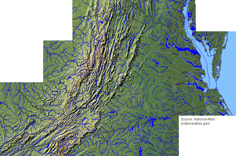
watershed divide at the headwaters of the Shenandoah River (arrows show the direction of the flow of the water - downhill, of course, but in different directions -
so think of the watershed divide as the tip of the roof separating the Shenandoah River on the north from the James River on the south)
Source: National Atlas
I'm flagellating an expired equine to excess, but you really gotta learn the watershed concept in order to understand the political debate over the Chesapeake Bay cleanup.
Representative Bob Goodlatte from the 6th District is trying to block funding of the Environmental Protection Agency's program to implement mandatory limits on pollution going downstream from the Shenandoah Valley to the bay. The farmers care about the Bay, Rep. Goodlatte cares about the Bay, and his district includes a chunk of the bay's watershed. Still, the threat of the Environmental Protection Agency regulating farming activities, from disposal of chicken litter to how close cows can graze next to streams, is a potent political issue for all elected officials and candidates for office.
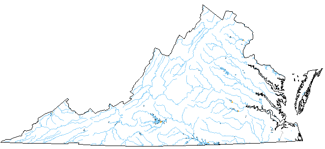
rivers in Virginia
Source: US Geological Survey National Atlas
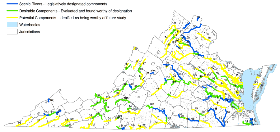
designated and potential Scenic Rivers in Virginia
Source: Virginia Department of Conservation and Recreation, Scenic Rivers Program
- in the map above, which of the five major physiographic regions in Virginia appears under-represented? (NOTE: since this map was produced, one new stretch in that physiographic region has been added)
parcel boundaries, showing fragmented ownership in Dragon Run watershed, complicating conservation efforts
(buildout analysis based on comprehensive plans showed almost 40,000 houses or other structures could be built on those parcels)
Source: Dragon Run Management Framework
Web Exercises
- Take a tour of Northern Virginia.
- Use the Surf Your Watershed tool from the Environmental Protection Agency, to identify the watershed for the place you chose for your site reports
(when you enter the zip code for GMU (22030) and click "go" - why does it list more than one watershed in response?)
- use the Virginia Hydrologic Unit Explorer to find the watershed for the site you chose for your field reports and Neighborhood Portfolio
search GNIS for features in Virginia called "lakes"
Map Exercises
- Trace the Bay using the DeLorme Virginia Atlas & Gazetteer. Get familiar with the political jurisdictions that have Chesapeake Bay shoreline in Virginia, as well as the brigdes/tunnels in Hampton Roads
- using the Drainage Basins and Watersheds of Virginia map from William and Mary and the Delorme Virginia Atlas and Gazetteer, take a trip down I-81 and decide in which watershed you would find Winchester, Harrisonburg, Staunton, Lexington, Roanoke, Blacksbur/Radford, and Bristol
Videos
- could you do better than the victims in the What is a Watershed video, co-produced by EPA and The Weather Channel?
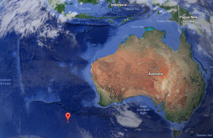
- watch "Travels Around George Mason University" on GMU-TV. Note that the website address for the class has changed since this segment was recorded. Also, remember that the antipode of the Fairfax Campus of GMU will be a location in the Southern Hemisphere, at roughly 39 degrees south of the equator. (My high tech geo-locator globe used in the video distracted me; the antipode is not 51 degrees south of the equator. The Antipodes Map is correct, while my statement in the video is... wrong. Duh. My bad.)
the antipode to the Fairfax Campus of George Mason University, the opposite side of the globe, is a spot in the Indian Ocean
Source: Google Maps
Site Visit
Examine a stream in the area chosen for your site visits. If you chose a highly-developed urban area, major portions of the streams may have been paved over and converted into storm sewers. Looking at local topography, can you identify the old stream valleys... and who might suffer from flooded basements during big storms?
For the field trip report, observe and report on the following:
- what is the name of your stream, and where did you choose to observe it? (If you don''t know its name, what name would you suggest would be appropriate for that stream, and why did you pick that name?)
- from the banks of the stream (or the bridge), determine what direction is upstream
- where is a watershed divide for your stream? If walking or driving in a certain direction, where would you say you had "crossed the divide" and entered the "headwaters" of another stream?
- what is the name of the stream on the other side of your watershed divide? (Remember, the "headwaters"of a stream is at the opposite end from the mouth of the stream. The headwaters will be at the highest location in that portion of the stream's watershed. For example, the furthest uphill headwaters of the Potomac River is marked by the Fairfax Stone in West Virginia, while the mouth is where the Potomac River enters the Chesapeake Bay.)
- do the sides of the stream (the "banks") and the bottom on the stream (the "bed") appear natural with green vegetation and minnows swimming in the pools of water, or has the stream been changed (degraded) extensively by human development? if so, what development had the greatest impact?
- are there any obvious environmental protections, such as protected buffer strips of vegetation, along the stream? Are there stormwater ponds, low dams, or other "built/engineered" controls that might reduce flood damage?
- do you think the runoff from a September rainstorm will be filtered and slowed to a gradual seepage before entering the stream, or will the rainfall rush almost immediately into the stream and stimulate a quick rise in water level downstream?
- what might be affected downstream by increased water levels? would a flash flood cover a greenway, soccer field, or parking lot... or are there buildings occupied by people, located right on the edge of the streambank?
- how could a potential homeowner, looking at a house near a creek, discover the risk of a flood at that location?
- based on what you know about your stream, you could articulate an informed opinion: should new buildings be permitted in the area that will flood so long as the owners are willing to buy flood insurance, or should the government define a boundary where no development should occur?
Great Falls of the Potomac River after heavy rainfall in September, 2011
(the waterfalls are located primarily in what state?)
 Virginia watersheds (do any Virginia rivers drain into Tennessee, Kentucky, or West Virginia?)
 southern Fairfax County/northern Prince William County, from I-66 to Lake Montclair
 many - but not all - streams in southeastern Virginia are tributaries of the Chesapeake Bay
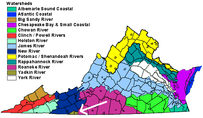

 "layers" displayed on this map include topography, rivers and waterbodies,

 designated and potential Scenic Rivers in Virginia

