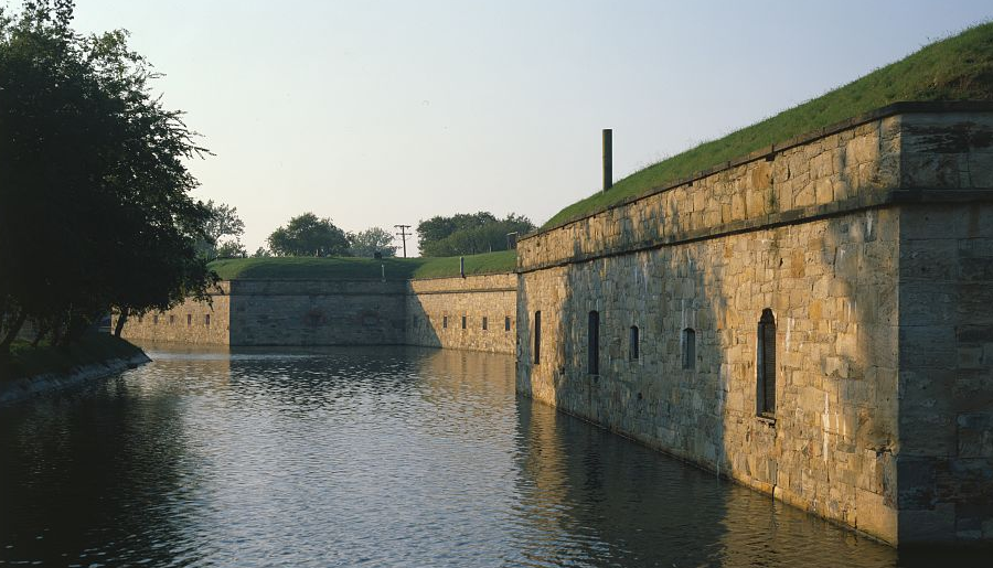
a moat surrounds Fort Monroe on Old Point Comfort
Source: Fort Monroe Authority, Master Plan 2013 Presentation to the Fort Monroe Board of Directors (October 24, 2013)
a moat surrounds Fort Monroe on Old Point Comfort
Source: Fort Monroe Authority, Master Plan 2013 Presentation to the Fort Monroe Board of Directors (October 24, 2013)
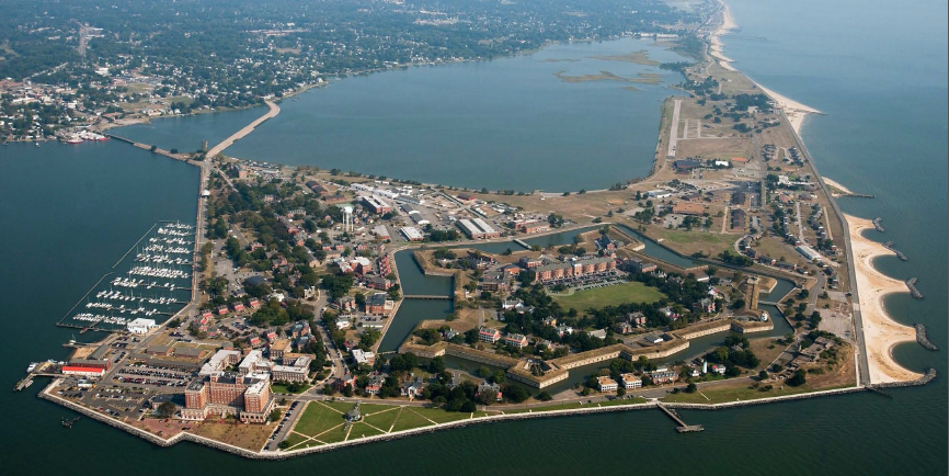
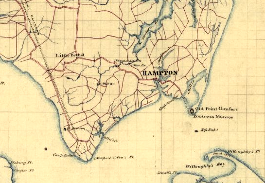
Fort Monroe is the last fort to be constructed on the tip of the Peninsula, replacing predecessors such as Fort Algernon (1610) and Fort George (1730). That tip, named Point Comfort by the English colonist who arrived in 1607 and were pleased to find a deep water channel sheltered from the storms in the Atlantic Ocean, is now known as Old Point Comfort. Another similar peninsula 20 miles north at Mobjack Bay is called New Point Comfort.1
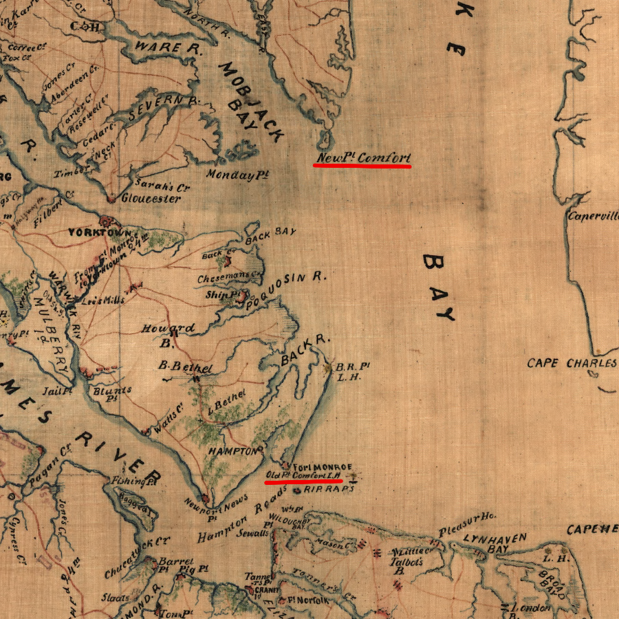
Old Point Comfort marked the James River entrance, and New Point Comfort marked the entrance into the York River
Source: Library of Congress, S.E. portion of Virginia and N.E. portion of N'th Carolina (by Thomas Jefferson Cram, 186_)
Ships sailing to Jamestown could come ashore and get fresh water at Point Comfort. Ships could also discharge cargo and in 1619, "20. and odd Negroes" were landed there, after being seized by privateers from a Portuguese slave ship. At Point Comfort, Governor Sir George Yeardley and Abraham Peirsey, the cape merchant of the colony responsible for managing supplies, purchased the first Africans brought involuntarily to Virginia.2
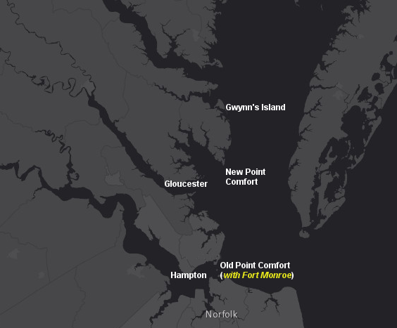
like Old Point Comfort, New Point Comfort is a sand spit on which a lighthouse was constructed to guide ships away from shoals - but no fort was built at New Point Comfort
Source: ESRI, ArcGIS Online
Starting in 1607, Virginians have used that site for defensive purposes. Fort George, the last fortification built there before Fort Monroe, was destroyed in a 1747 hurricane. For nearly 80 years afterwards, including the difficult times of the Revolutionary War and the War of 1812, Virginia was invaded successfully by hostile European enemies because there was no American fort on Old Point Comfort.
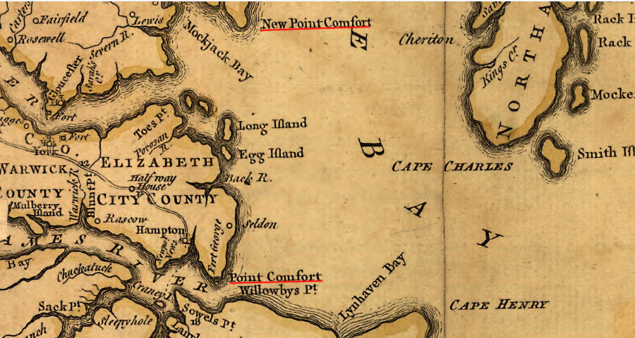
the Fry-Jefferson map recorded both Point Comfort and New Point Comfort
Source: Library of Congress, A map of the most inhabited part of Virginia (by Joshua Fry and Peter Jefferson, 1757)
The need for military protection at the mouth of the James River was made clear when Portsmouth and Norfolk were seized by Lord Dunmore and his British ships at the start of the Revolutionary War. The Virginia Navy was too weak to deter the British warships from sailing wherever they wished.
When the Royal Navy atempted to capture Hampton in 1775, riflemen in Colonel William Woodford's Second Virginia Regiment killed sailors exposed on the decks. The riflemen successfully blocked the fleet from sailing up the Hampton River, but there was no fort on Point Comfort with cannon to sink British ships. Fort George, which had been built in 1728, had been destroyed in a 1749 hurricane.
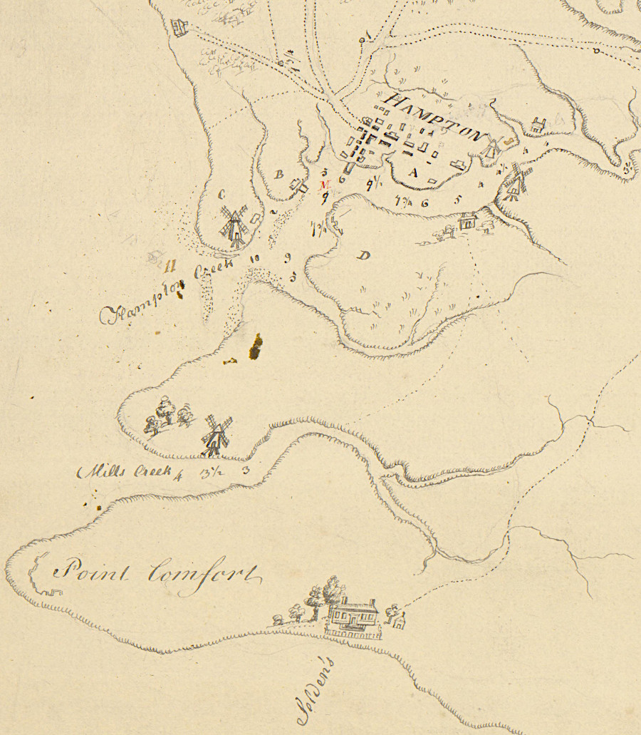
Point Comfort was not fortified at the start of the Revolutionary War
Source: University of Michigan, William L. Clements Library, A sketch of the east end of the peninsula where on is Hampton (1781)
After the Revolutionary War, the new Federal government built the first and second "systems" of forts in other locations. The first structure funded by the new United States government at Old Point Comfort was a 54' tall lighthouse. It was built in 1803 to facilitate interstate and international commerce. Oil lanterns illuminated a light that could be seen for 14 miles.3
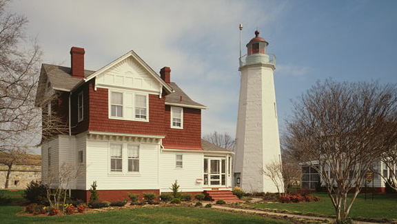
Fort Monroe lighthouse
Source: Library of Congress, Fort Monroe, Old Point Comfort Lighthouse, Ingalls Road, Hampton, VA
In 1813, after the quickly-built fortifications on Craney Island blocked the British Navy from moving up the Elizabeth River and destroying the Gosport Navy Yard, the British seized the Old Point Comfort lighthouse. They landed troops on the Peninsula, captured Hampton, and pillaged the town. (The lighthouse survived the Civil War because the Union forces retained control of Fort Monroe throughout that conflict.)3
The trigger for construction of the Third System of forts was the inability of the United States to block the British Navy during the War of 1812. Fort Monroe, the largest in the Third System, was started in 1819; the still-surviving Quarters No. 1 dates from that year. The incomplete fort was occupied in 1824 and served as the home of the Artillery School of Practice, but construction continued for another decade.
Much of Old Point Comfort has been covered since then with structures associated with the military base, including hotels such as the Hygeia and Chamberlin that catered to fort contractors, families of officers, and tourists seeking a resort experience at Hampton Roads. The military and private developers at Old Point Comfort have modified or torn down structures there since the base was established; Fort Monroe is not a time capsule of buildings preserved since original construction or even the Civil War.4
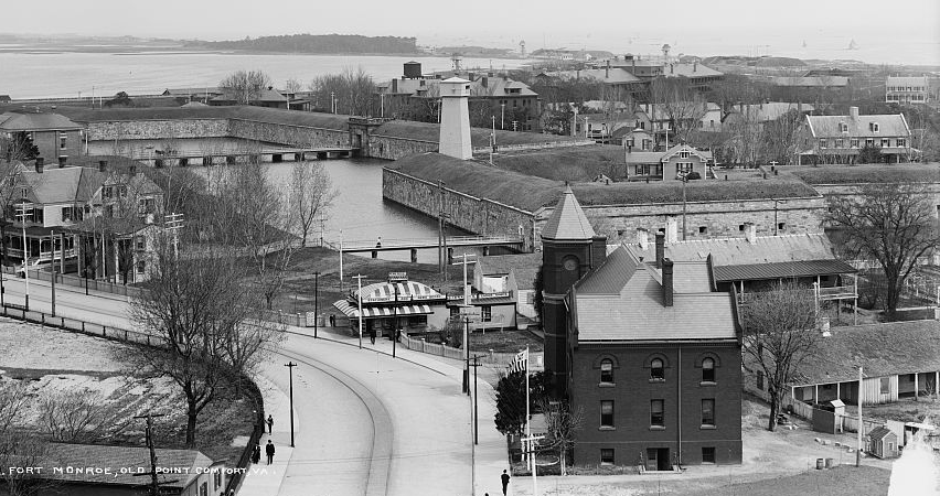
Fort Monroe around 1905, as seen from The Chamberlin
Source: Library of Congress, Fort Monroe, Old Point Comfort, VA
Virginia donated 250 acres at Old Point Comfort to the Federal government for Fort Monroe, plus 15 acres of submerged land at the Rip-Raps shoal off Old Point Comfort to build Fort Calhoun. The state formally agreed to donate the land in 1821, two years after the Federal government started construction. The deed transferring the land to the Federal government was finally executed in 1838, and the state sold an additional 31 acres of submerged lands underneath Mill Creek to the Federal Government in 1908.5
The fort was based on the designs of a French military engineer, Simon Bernard. It was named for President James Monroe, who was in office when construction started. Building a large stone fort at Old Point Comfort was a challenge. The soft sand and clay that had been deposited by currents at Old Point Comfort made a poor foundation for the heavy stone structure.
The military engineers in the US Army chose to build Fort Monroe out of stone, while bricks were used for constructing other Third System forts. There are no rock quarries near that site on the Coastal Plain, and the engineers rejected the first rock purchased from a quarry on the York River as too soft. Stone that met the engineer's standards for hardness was shipped from Georgetown on the Potomac River. To adjust to soft soil conditions, engineers modified the hexagonal design of the fort on the west side and created an uneven shape with seven sides.6
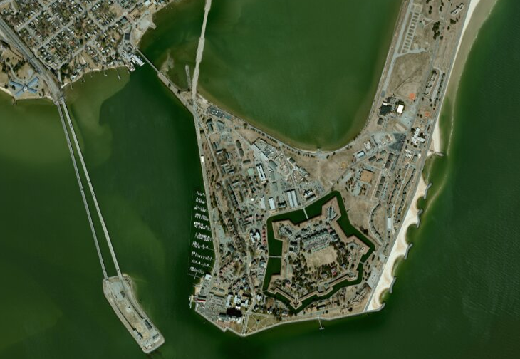
Fort Monroe is at the eastern tip of the Peninsula, next to the Hampton Roads Bridge-Tunnel
Source: ESRI, ArcGIS Online
Based on the experience of the War of 1812, the Secretary of War wanted to be prepared in case an enemy crossed the Atlantic Ocean with a major army as well as a fleet of warships. The instructions to build such a massive stone fort at Old Point Comfort were based upon the supposition that:7
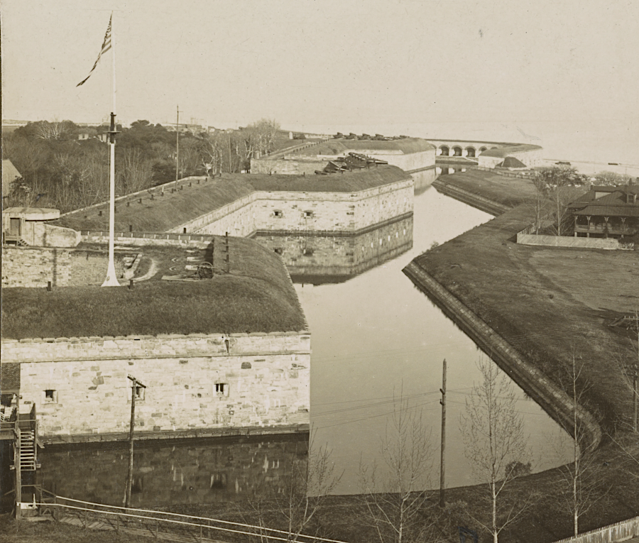
The 10-foot thick walls behind the 8-foot deep moat could support 400 cannon of various sizes. The huge Lincoln Gun, installed at Fort Monroe in 1862 after the battle between the CSS Virginia and USS Monitor, fired solid shot (cannonballs) weighing 437 pounds.8
Fort Monroe was designed (perhaps excessively...) to resist a siege by a European army
Source: Library of Congress, General view of the west rampart and moat, looking from the south
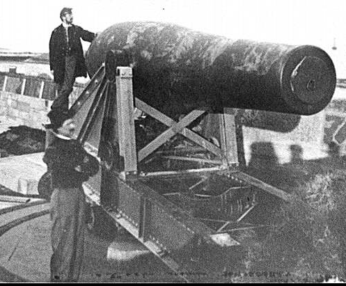
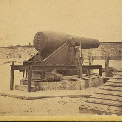
during the Civil War, massive guns at Fort Monroe were intended to block Confederate ships from using Hampton Roads
Source: Library of Congress, Fort Monroe, Va. The "Lincoln Gun," a 15-inch Rodman Columbiad and The 15 in. gun at Fortress Monroe, Va
Robert E. Lee was one of many US Army engineers who worked on the largest stone fort in the United States. The reach of the massive cannon at Fort Monroe was still inadequate; enemy ships could maneuver through the gap between Willoughby Spit/Cape Comfort to enter the shipping channels up the Elizabeth River into Norfolk/Portsmouth and up the James River to Richmond.
To limit that threat, the Rip-Rap Shoals a mile offshore from Fort Monroe were converted from a shallow sand bar/oyster bar into Fort Calhoun. In 1862, when the former US Secretary of War John C. Calhoun was identified most closely with his advocacy for secession, Fort Calhoun was renamed Fort Wool. Union General John Wool commanded Fort Monroe, and just before Fort Calhoun was renamed he had led the Union forces that captured Norfolk from the Confederates.
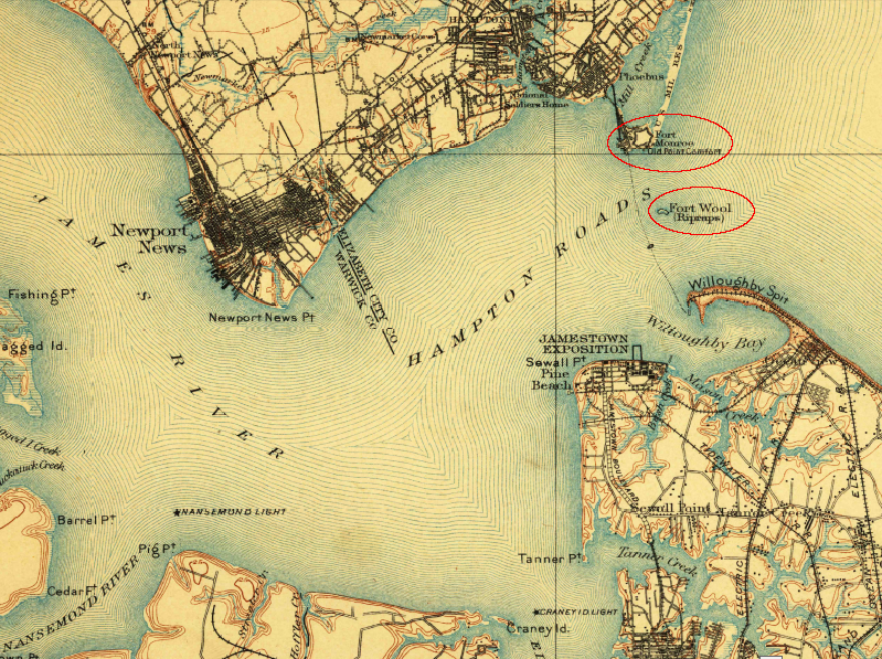
cannons at Fort Monroe could not control the Hampton Roads shipping channels, so Fort Wool was constructed on the Rip-Raps shoal
Source: US Geological Survey (USGS), Norfolk Special 30x30 topo (1907)
Fort Monroe remained in Union hands during the entire Civil War, and was a key base for the 1862 Peninsula Campaign. Though that massive stone fort was intended to withstand attack by a hostile navy, cannon at Fort Monroe were fired only once at an enemy - the CSS Virginia, when that ironclad dueled with the USS Monitor in 1862. Though cannonballs bounced off the CSS Virginia, the shore batteries were effective when targeting other ships in the Confederate fleet. In February 1865, the guns of Fort Monroe protected the River Queen when Abraham Lincoln used that boat to meet with Confederate negotiators at the Hampton Roads Peace Conference.9
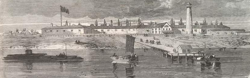
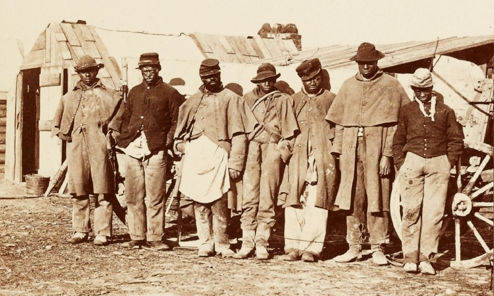
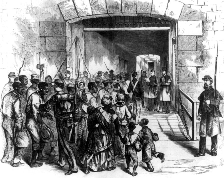
the Federal army retained control over Fort Monroe, and it became "freedom's fortress" for contrabands
Source: Illustrated London News, The Civil War in America. Fort Monroe, Virginia, as seen from the James River (May 25, 1861)
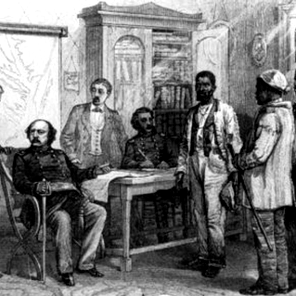
The fort's most historic role may have come at the beginning of the war, when General Benjamin Butler refused to return escaped slaves to Virginian slave-owners on May 23, 1861. President Lincoln had reassigned Butler, a Democratic politician from Massachusetts, to Fort Monroe after creating an uproar in Baltimore by declaring martial law rather than seeking to mollify secessionists there to keep Maryland in the Union. At Fort Monroe, Butler once again created controversy.
Three enslaved men, Frank Baker, Shepard Mallory and James Townsend, fled by boat across the James River and sought asylum at the fort in April, 1861. Confederate Major John Cary went to Fort Monroe and demanded their return. Union General Benjamin Butler cited Virginia's secession from the Union, which in Southern eyes created an international boundary, and declared that the Fugitive Slave Act no longer applied. Instead, Butler was seizing the three men as enemy property or "contrabands of war."
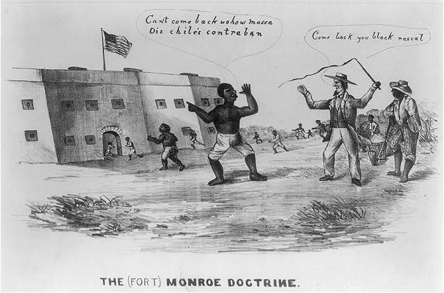
at Fort Monroe, Union soldiers provided the force that allowed escaped slaves to cite their status as contrabands and block attempts to return them to Virginia plantations
Source: Library of Congress, The (Fort) Monroe Doctrine
Confederate Colonel Charles K. Mallory claimed his three enslaved men were property. Legally, he was trapped by Butler's claim that the three men were contraband property.
Butler did not declare those slaves to be free men. Still, by refusing to return them to their owner, he initiated the process that led to Lincoln changing his war aims. Congress passed the First Confiscation Act of 1861 and the Second Confiscation Act of 1862, and Lincoln announced the Emancipation Proclamation in September, 1862. Using the Union military to create safe havens for escaped slaves helped shift the focus of the Civil War from just reuniting the 33 states, and added the war aim of eliminating slavery.
Cary was later promoted to Colonel. After the war, he served for several years as superintendent of public schools in Richmond and became a leading advocate of the "Lost Cause" interpretation of the Civil War and a champion of the effort to build a monument in Richmond to former Confederate President Jefferson Davis. Two schools were named after Colonel Cary, in Hampton and Richmond. The Hampton school was renamed in 2021, and the Richmond School Board started the process to rename its Cary Elementary in 2022.
Fort Monroe is sometimes called "Freedom's Fort" as a result of General Butler's decision to classify escaped slaves as contrabands and retain them within Union lines:10
Source: National Park Service, Escaped Slaves and Fort Monroe and the "Contrabands of War"
Harper's Weekly quickly publicized the arrival of fugitive slaves at Fort Monroe and the decision to treat them as contraband of war
Source: Library of Congress, Stampede among the Negroes in Virginia - their arrival at Fortress Monroe (1861)
The cannon at Fort Monroe provided protection for US Navy ships when the CSS Virginia sailed out of the Elizabeth River in March, 1862. When the Union army landed at Willoughby Point and marched towards Norfolk, the Confederates abandoned the Norfolk Navy Yard and destroyed the CSS Virginia. The rest of the Confederate Navy in Virginia moved up the James River, and was trapped upstream for the remainder of the war. Fort Monroe never had to fire its cannon again at the enemy.
The primary role for Fort Monroe during the Civil War was to serve as a supply depot and hospital for wounded soldiers. Engineer Wharf could not handle all the traffic, so Baltimore Wharf was built in 1862 to provide a new landing spot for steamships. (Baltimore Wharf lasted for 99 years, but after steamship travel ended it was removed in 1961.)11
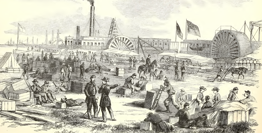
during the Civil War Fort Monroe stockpiled and shipped supplies, and served as a hospital
Source: Frank Leslie's Illustrated History of the Civil War, Reception of Wounded Soldiers by the Federal Authorities at Fortress Monroe, VA - The Cars Conveying Them to the Hospital - Surgeons Dressing Their Wounds (p.152)
As the population at the fort increased, the demand for water increased beyond previous supply available from cisterns. Union forces moved across Mill Creek and "invaded" Virginia on May 13, 1861 in order to access a fresh water well. At that site, Camp Hamilton evolved into a refuge for escaped contrabands known as Slabtown.12
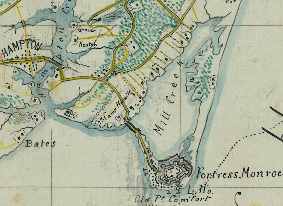
as Federal soldiers were sent to Fort Monroe in 1861, Camp Hamilton was established to provide a more-reliable water supply
Source: National Archives, Sheet No. 1 Military Reconnaissance and Library of Congress, Camp Hamilton, Fortress Monroe, Va
In the 1860's, 1890's, and early 1900's the US Army drilled wells, some over 2,000 feet deep, but never found fresh water. The military ended up building a plant to distill drinking water, then finally connected to the system that supplied Newport News.13
The absence of fresh water at Old Point Comfort was not understood until the US Geological Survey determined that aquifers had been disrupted by the impact of a metor or comet ("bolide") 35 million years earlier. The sedimentary layers at Fort Monroe that normally accumulate fresh rainwater were filled instead with salt water that had been trapped by the ancient impact.14
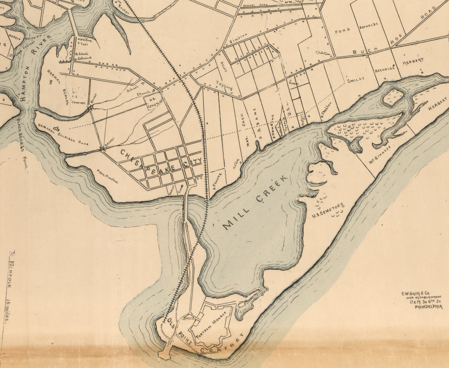
After the Civil War, the US military continued to use Fort Monroe as a major base. In 1893 a trolley line linked Baltimore Wharf with Phoebus, parallel to Ingalls Street and crossing a new bridge completed in 1890 over Mill Creek. In 1895, an electrical system was installed, and it was followed a year later by the first sewage system.15
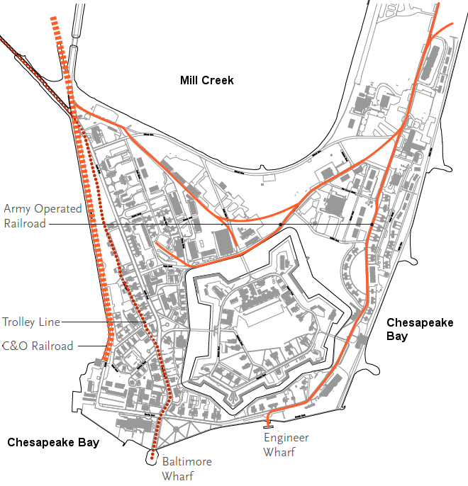
Fort Monroe once had a Chesapeake and Ohio rail terminal, a trolley on Ingalls Street, and a US Army railroad to service the Endicott batteries
Source: Fort Monroe Authority, Fort Monroe
National Historic Landmark District
The Civil War had demonstrated that rifled cannon on ironclad ships had made masonry forts vulnerable. Though Fort Monroe was unique in the Third System of forts with stone rather than brick walls, it too was no longer able to resist attack. The cannon on the walls of the fort were intended to blast holes in the hulls of attacking ships, but the ironclads ended up with more-powerful cannon that could blast holes in the fort's walls.
Between 1891-1901, Fort Monroe was upgraded with new waterfront batteries that had a longer range, based on the recommendations of Secretary of War William Endicott. The Endicott batteries included mortars designed to launch projectiles in a high arc to crash through lightly-armored decks of warships, rather than the heavily-armored hulls:16
Fort Monroe was upgraded with Endicott batteries in 1891-1901
Source: Library of Congress, Fortress Monroe, Old Point Comfort, Va. (1901)
The Spanish fleet based in Cuba never tested the defenses of Fort Monroe during the 1898 Spanish-America War. The US Army required removal of the Hygia Hotel in 1902, anticipating expansion of Fort Monroe, but the land was left vacant.
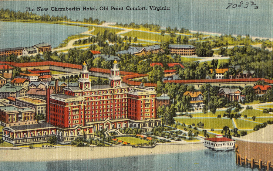
The Chamberlin (second version, built after a 1920 fire destroyed the first hotel) benefitted from a recreational waterfront at Fort Monroe
Source: Boston Public Library, The new Chamberlin Hotel, Old Point Comfort, Virginia
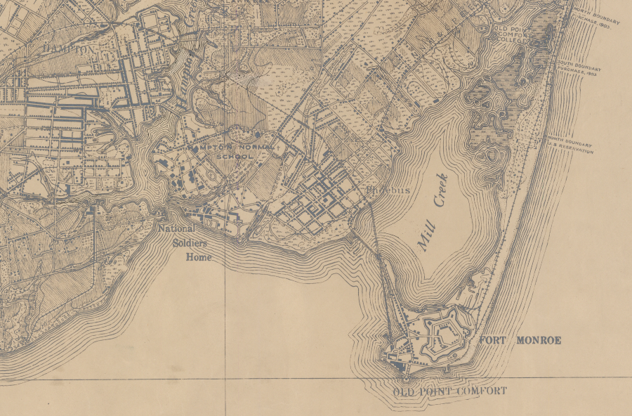
The Coastal Artillery School was created in 1907 and placed at Fort Monroe. The addition of that unit led to new construction outside of the stone fort. Many of the structures on Ingalls Road, the "main street" of the fort connecting the Main Gate to Baltimore Wharf, were built after 1907 to support the Coastal Artillery School.17
locating the Coastal Artillery School at Fort Monroe in 1907 led to construction of additional facilities on Ingalls Road
Source: US Geological Survey (USGS), Hampton 7.5x7.5 topographic map (2013)
Fort Monroe's guns provided no effective defense against German U-boats in World War II. The outdated artillery pieces at Fort Monroe were melted down for scrap metal, and control of Hampton Roads was ensured by ships (including submarines) and aircraft rather than coast artillery. Fort Monroe was used to train artillery officers until the end of World War II. In 1974 the fort assumed its last major mission, serving as the headquarters of the US Army Training and Doctrine Command (TRADOC).
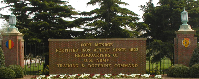
Fort Monroe served as the headquarters for the Training And Doctrine Command (TRADOC) from 1973 until closure of the base in 2011
Source: Fort Monroe Online Heritage Project, Fort Monroe Main Gate
Hurricane Isabel in 2003 demonstrated the vulnerability of Old Point Comfort to flooding, causing $100 million in damage. Isabel was just a Category 2 hurricane but the storm arrived at high tide. Water levels rose three feet higher than the previous record flooding in 1933, destroying piers and flooding military housing units within the moat. One resident commented:18
The US Army response after Hurricane Isabel was the Fort Monroe Flood Proofing project, including a new seawall costing $20 million. It was 9.5 feet high, two feet higher than the old seawall, and provided protection against floods expected to occur once every 25 years rather than the old 5-year flood protection. The US Army Corps of Engineers also installed gates on nearly 30 storm drain outfalls. The back flow preventers reduced the risk of flooding basements, and minimized the potential of new flooding washing nutrients into the Chesapeake Bay.
Those major parts of the Fort Monroe Flood Proofing project were completed even after the Base Realignment and Closure (BRAC) Commission determined in 2005 that Fort Monroe should be closed. As a result of the BRAC decision to reduce costs by consolidating military installations, military activities at Fort Monroe were transferred to Fort Eustis (except for two units sent to Fort Knox) by the end of 2011.
The BRAC process calculated that benefits of closing the base would far exceed costs, though the local community would lose 3,600 military, civilian, and contractor jobs. The $72 million in costs to close the base would be recovered in just one year.19
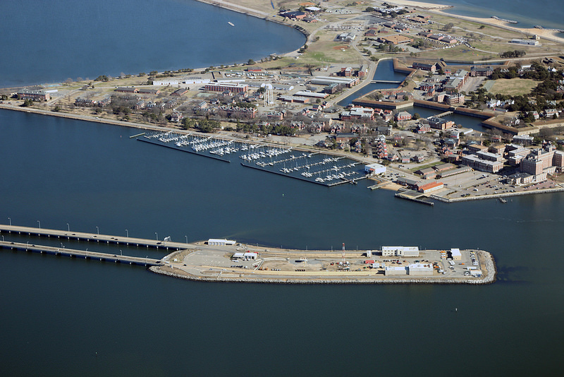
travelers on the Hampton Roads Bridge-Tunnel can see Fort Monroe
Source: Virginia Department of Transportation, Hampton Roads Bridge Tunnel
One of the many impacts of closing the military base: future costs to recover from storms and to protect structures at Old Point Comfort from sea level rise will have to be funded from sources other than the Department of Defense budget.20
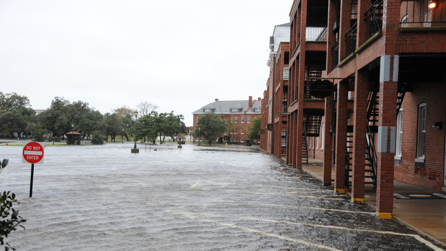
flooding at Fort Monroe (shown here after a November, 2009 northeaster) still occurs despite the Fort Monroe Flood Proofing project
Source: Fort Monroe Online Heritage Project, November Nor'easter
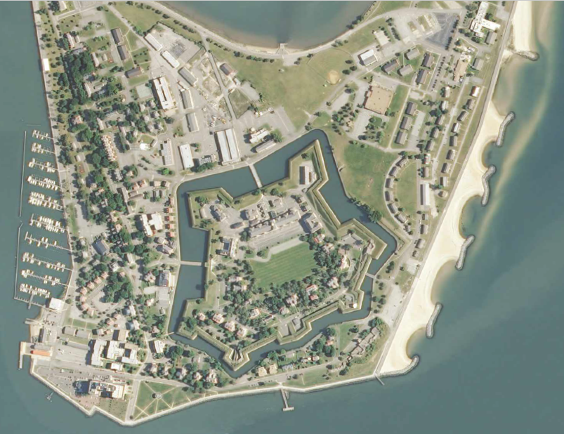
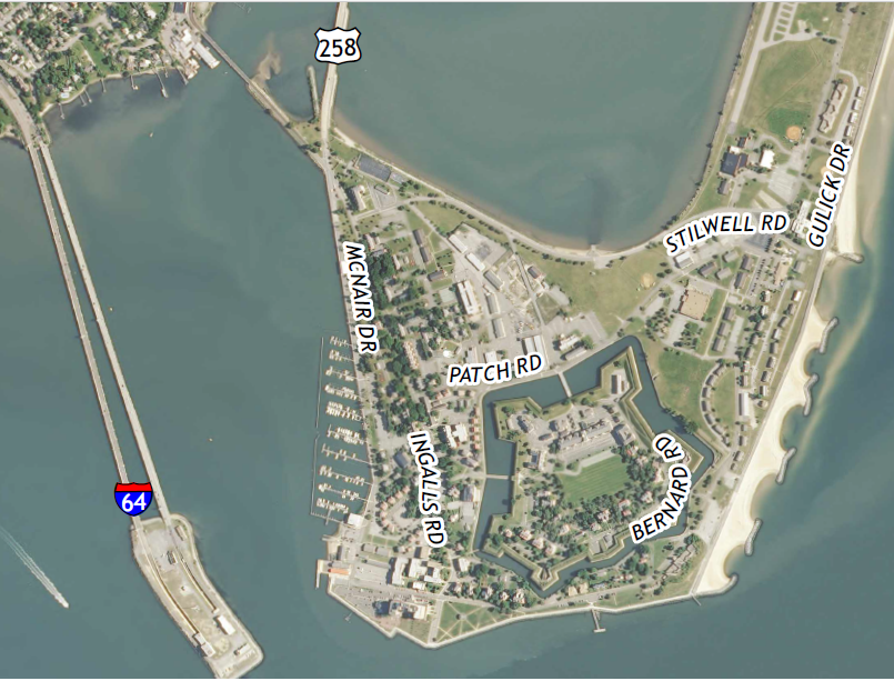
the eastern shoreline at Fort Monroe is protected by artificial breakwaters, while the western side has a marina sheltered from storms by Point Comfort
Source: US Geological Survey (USGS), Hampton 7.5x7.5 topographic map (2013)
In 2018, Amazon invited communities to compete for the location of its second headquarters. The Hampton Roads proposal centered on using the North Gate Redevelopment area of Fort Monroe, plus the Woodlands Golf Course. Fort Monroe could offer a million square feet of vacant building space in a compact location, with adaptive reuse of those structures with a historic designation.
Amazon did not pursue the possibility. The transit and airport transportation choices, and the larger pool of a skilled workforce, led the company to choose a site in Arlington County for half of HQ2.21
no railroad was built to Fort Monroe until Harrison Phoebus convinced the Chesapeake and Ohio Railroad to build a trestle across Mill Creek to the Hygeia Hotel in 1890, for tourists to access Old Point Comfort
Source: Library of Congress, James City, York, Warwick, and Elizabeth City counties, Virginia (1892)
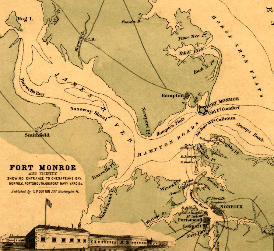
guns at Fort Monroe did not have the reach to control the shipping lanes, so Fort Calhoun (renamed Fort Wool) was constructed on the Rip Raps shoal
Source: Library of Congress, Fort Monroe and vicinity showing entrance to Chesapeake Bay, Norfolk, Portsmouth, Gosport Navy Yard &c.
1. "Old Point Comfort," Encyclopedia Brittanica, http://www.britannica.com/place/Old-Point-Comfort (last checked August 30, 2015)
2. Martha McCartney, "Virginia's First Africans," Encyclopedia Virginia, Virginia Foundation for the Humanities, July 12, 2012, http://www.encyclopediavirginia.org/virginia_s_first_africans (last checked August 30, 2015)
3. "Historic Sites & Walking Tour," Fort Monroe Authority, https://fortmonroe.org/explore/historic-sites/; "Lord Dunmore's Navy in Hampton Roads, 1775-1776, Part I: The Battle of Hampton," Hampton Roads Naval Museum, October 27, 2016, https://hamptonroadsnavalmuseum.blogspot.com/2016/10/lord-dunmores-navy-in-hampton-roads.html (last checked December 23, 2022)
4. "Old Point Comfort, VA," LighthouseFriends.com, http://www.lighthousefriends.com/light.asp?ID=444; "Foundation Document - Fort Monroe National Monument," National Park Service, July 2015, p.7, http://www.nps.gov/fomr/learn/management/upload/FOMR_FD_2015.pdf (last checked August 30, 2015)
5. "The Architectural Heritage of Fort Monroe," National Park Service, 1987, p.10-11, http://www.nps.gov/parkhistory/online_books/nnps/fort_monroe.pdf (last checked December 23, 2014)
6. "Fort Monroe," Virginia Department of Historic resources, National Register Nomination Form, 1976, http://www.dhr.virginia.gov/registers/Cities/Hampton/114-0002_%20Fort_Monroe_1975_Final_NHL_Nomination.pdf; "Fort Monroe Historic Preservation Manual and Design Standards," Hanbury Evans Wright Vlattas + Company, August 2011, p.1B.2, http://www.fmauthority.com/wp-content/uploads/Design-Standards-Aug2011_Volume1_compressed.pdf
(last checked August 31, 2015)
7. J. Arnold Dalby, A History of Old Point Comfort and Fortress Monroe, VA, Landmark Steam Book and Job Presses, 1881, p.33, https://books.google.com/books?id=cEdEAQAAMAAJ (last checked January 20, 2015)
8. "Fort Monroe's Lasting Place in History," Smithsonian, July 4, 2011, http://www.smithsonianmag.com/history/fort-monroes-lasting-place-in-history-25923793/; "Fort Monroe," Fort Wiki, http://www.fortwiki.com/Fort_Monroe; "Defending Civil War Fort Monroe with the massive Lincoln Gun," Newport News Daily Press, April 2, 2014, http://www.dailypress.com/features/history/our-story/dp-defending-civil-war-fort-monroe-with-the-massive-lincoln-gun-20140402-post.html (last checked December 23, 2014)
9. "The Ironclad Ram Virginia-Confederate States Navy And Her Memorable Engagements of March 8 and 9, 1862," Southern Historical Society Papers, Volume 32, 1904, p.243-249, http://cssvirginia.org/vacsn4/original/cw04shsp.htm (last checked December 23, 2014)
10. "Fort Monroe and the "Contrabands of War," National Park Service, http://www.nps.gov/resources/story.htm?id=255; "Slavery, Freedom, and Fort Monroe," Colonial Williamsburg Journal, Colonial Williamsburg, Winter 2010, http://www.achp.gov/fort_monroe_final_story.pdf;
"The Black Roots of Memorial Day," The Root, May 26 2014, http://www.theroot.com/articles/history/2014/05/how_did_fort_monroe_become_freedom_s_fort.html; "Foundation Document - Fort Monroe National Monument," National Park Service, July 2015, p.9, http://www.nps.gov/fomr/learn/management/upload/FOMR_FD_2015.pdf; "Hampton to rename its John B. Cary Elementary and 4 other schools," Richmond Times-Dispatch, May 19, 2021, https://richmond.com/news/state-and-regional/hampton-to-rename-its-john-b-cary-elementary-and-4-other-schools/article_e4b7bfb4-9345-5db5-bde0-2c3dbff96dfb.html; "The Last Confederate," Richmond Style Weekly, April 11, 2022, https://www.styleweekly.com/richmond/the-last-confederate/Content?oid=18651984 (last checked April 13, 2022)
11. "Fort Monroe National Historic Landmark District," Fort Monroe Historic Preservation Manual and Design Standards, Fort Monroe Authority, p.1C.9, http://www.fmauthority.com/wp-content/uploads/06_1C-Natl_Historic_Landmark_District.pdf (last checked August 31, 2015)
12. "Foundation Document - Fort Monroe National Monument," National Park Service, July 2015, p.10, http://www.nps.gov/fomr/learn/management/upload/FOMR_FD_2015.pdf; Fort Monroe: Key to the South, John V. Quarstein, Dennis P. Mroczkowski, Arcadia Publishing, 2000, p.30, https://books.google.com/books?id=kSZv7unExEQC (last checked August 30, 2015)
13. William Bullock Clark, Benjamin LeRoy Miller, Edward Wilber Berry, Thomas Leonard Watson, "The Physiography and Geology of the Coastal Plain Province of Virginia," Bulletin, Virginia Division of Mineral Resources, No. IV, 1912, p.161, https://books.google.com/books?id=XSwQAAAAIAAJ; "Report of the Surgeon General," Annual Reports of the War Department, Government Printing Office, 1904, p.141, https://books.google.com/books?id=AARHAQAAIAAJ; "2013 Consumer Confidence Report on the Quality of Tap Water at Fort Monroe," Fort Monroe Authority, 2013, http://www.fmauthority.com/wp-content/uploads/2013-Consumer-Confidence-Report-on-the-Quality-of-Tap-Water-at-Fort-Monroe.pdf; John V. Quarstein, Dennis P. Mroczkowski, Fort Monroe: The Key to the South, Arcadia Publishing, 2000, pp.30-31, https://books.google.com/books?id=kSZv7unExEQC (last checked December 26, 2014)
14. C. Wylie Poag, "The Chesapeake Bay Bolide: Modern Consequences of an Ancient Cataclysm," US Geological Survey, https://woodshole.er.usgs.gov/epubs/bolide/ (last checked January 24, 2017)
15. "The Architectural Heritage of Fort Monroe," National Park Service, 1987, p.27, http://www.nps.gov/parkhistory/online_books/nnps/fort_monroe.pdf; "Fort Monroe National Historic Landmark District," Fort Monroe Historic Preservation Manual and Design Standards, Fort Monroe Authority, p.1C.9, http://www.fmauthority.com/wp-content/uploads/06_1C-Natl_Historic_Landmark_District.pdf (last checked January 11, 2015)
16. "Foundation Document - Fort Monroe National Monument," National Park Service, July 2015, p.12, p.18, http://www.nps.gov/fomr/learn/management/upload/FOMR_FD_2015.pdf; "Fort Monroe Resource Inventory," Fort Monroe Authority, June 18, 2010, p.4C-294, http://www.fmauthority.com/wp-content/uploads/j_Batteries.pdf (last checked December 23, 2014)
17. "Fort Monroe National Historic Landmark District," Fort Monroe Historic Preservation Manual and Design Standards, Fort Monroe Authority, 1C.5, http://www.fmauthority.com/wp-content/uploads/06_1C-Natl_Historic_Landmark_District.pdf (last checked August 31, 2015)
18. "Isabel Rewrites Fort Monroe History," Newport News Daily Press, September 23, 2003, http://articles.dailypress.com/2003-09-23/news/0309230056_1_unexploded-shells-and-bombs-moat-hurricane-isabel (last checked January 11, 2015)
19. "BRAC DoD Report by Commission Recommendation Number," Defense Base Closure and Realignment Commission, 2005, p.6, http://www.brac.gov/docs/DCN_8107_BRAC_DoD_Report_by_Comissions_Recommendatin_Number.pdf (last checked August 30, 2015)
20. "Norfolk District has unorthodox 'farewell' gift for Fort Monroe," US Army, March 30, 2011, http://www.army.mil/article/54063/Norfolk_District_has_unorothodox__quot_farewell_quot__gift_for_Fort_Monroe/ (last checked January 11, 2015)
21. "Luring Amazon to Hampton described as a worthwhile longshot," Daily Press, December 14, 2018, https://www.dailypress.com/news/hampton/dp-nws-hampton-amazon-20181212-story.html (last checked December 16, 2018)
Fortress Monroe in 1892, before peninsula was expanded by landfilling and accretion
Source: Library of Congress, Map of Elizabeth City CO, VA (1892)
Fort Monroe in 1911
Source: US Geological Survey, Vicinity of Fort Monroe, peninsula between York and James Rivers, Virginia (1910-1911, Sheet 1)