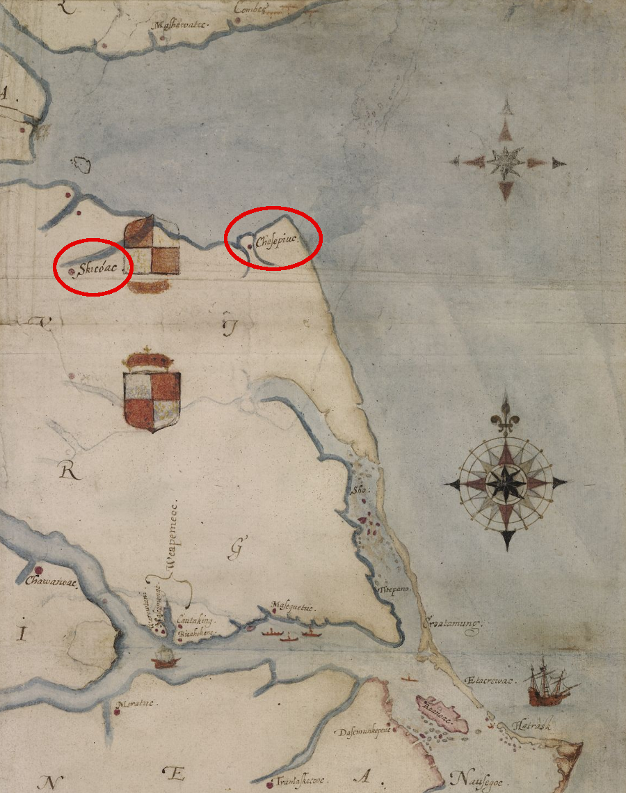
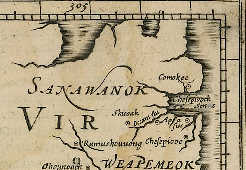
John White documented the locations of two major towns of the Chesapeake tribe after visiting in 1585-86
Source: British Museum, "La Virginea Pars," map of the E coast of N America from Chesapeake bay to Cape Lookout (John White, 1585-1593)
John White documented the locations of two major towns of the Chesapeake tribe after visiting in 1585-86
Source: British Museum, "La Virginea Pars," map of the E coast of N America from Chesapeake bay to Cape Lookout (John White, 1585-1593)
The Chesapeake tribe was conquered by Powhatan. Their territory at the mouth of the Chesapeake Bay, in what today is the City of Virginia Beach, was incorporated into his paramount kingdom around 1607.
The English had started exploring the Chesapeake Bay again in 1603. A ship captain seized captives from the Rappahannock and killed the chief of that tribe, making clear to the Native Americans that the European visitors were a threat.1
That action in 1603 could have triggered Powhatan to expand his territory in preparation for an invasion by alien trespassers, strangers called "tassantassas." Powhatan must have known about the previous attempt of the English to live with the Chesapeake tribe 17 years earlier.
Sometime during the winter of 1585-86, English colonists from Roanoke Island traveled north and spent time with the Chesapeake.
There were at least two Chesapeake towns surrounded by wooden walls (palisades). The main towns were Chesepioc (at modern Great Neck, on the East Branch of the Lynnhaven River) and Skicoak (on the modern Elizabeth River). A third town, Apasus, may have been located at Lynnhaven inlet.
The stay must have been peaceful, because the 1587 colony was supposed to sail through the Chesapeake Bay and land there.
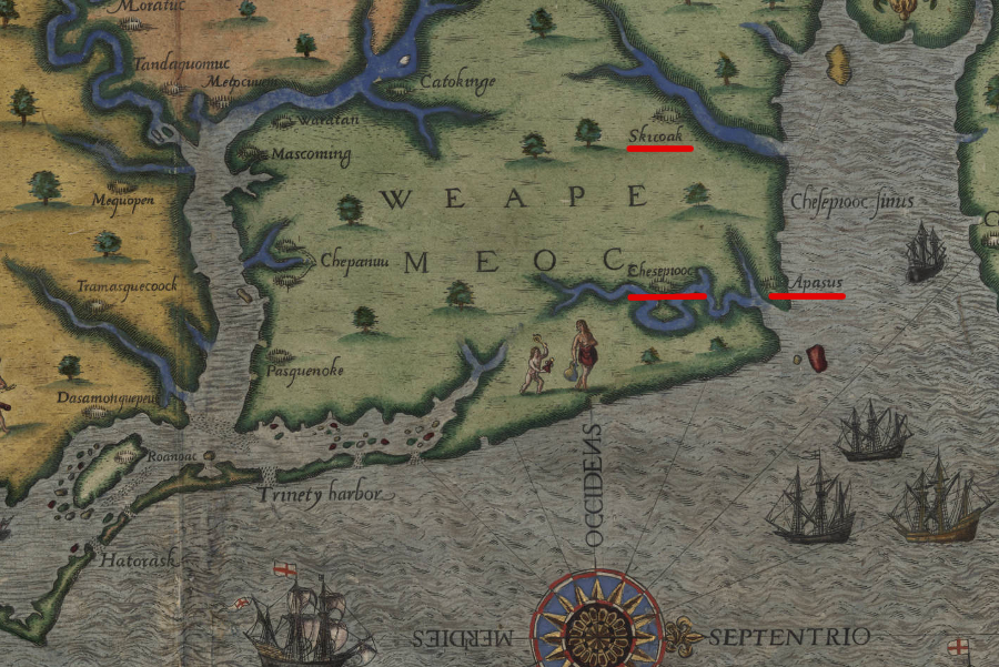
a watercolorist working from John White's original information identified three palisaded towns in the territory of the Chesapeake
Source: University of North Carolina Library at Chapel Hill, Map of Raleigh's Virginia
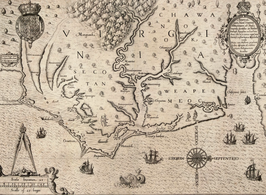
Theodor de Bry published an engraving, based on John White's painting, showing three palisaded towns in the territory of the Chesapeakes
Source: LearnNC, The Carte of All the Coast of Virginia (by Theodor de Bry)
The ship bringing those colonists reached the old site of Roanoke Island first. The pilot, Simon Fernandes, told his passengers that he would take them no further. He may have expected to gain greater wealth from seizing Spanish ships, being a pirate rather than fulfilling the terms of his contract.
Governor John White did not stay with the colony. He returned back with the ship, to arrange for a resupply of the isolated colony. He left behind 117 people. They became known as the "Lost Colony," since none were found when White returned in 1590.2
One speculation about their fate is that some of them moved north, leaving Roanoke Island and moving in with the Chesapeake. By the time the Virginia Company sent its first colonists to Virginia in 1607, the original colonists were probably dead.
They could have died from natural causes over 20 years, in a land with limited food and shelter They could have died from arrogantly picking fights with the Chesapeake or with visitors from other tribes.
The colonists had not shown great respect for a different culture, or negotiating skills to resolve conflicts peacefully, while living on Roanoke Island. Unless they made a dramatic change in their ways of dealing with Native Americans, the colonists probably demonstrated the same behavior among the Chesapeakes that had worn out their welcome on Roanoke Island.3
The 300-400 members of the Chesapeake tribe were outside the boundaries of Tsenacommacah, the territory of Powhatan's paramount chiefdom, until about the time the English arrived in 1607. He had been expanding his control eastward since he inherited six towns. After conquering the Kecoughtans (who lived at what is now the city of Hampton), he seized control of the Chesapeakes just before or soon after Jamestown was settled by the English. In 1608, he would conquer the Piankatank.
He replaced the adult Chesapeake men with loyal subjects and installed a new weroance. William Strachey, who arrived in the colony in 1610, reported that Powhatan had been warned by his priests that:4
John Smith mapped only one Chesapeake town. It appears to be at the location of Skicoak, now the city of Norfolk. The towns of Apasus and Chesepioc, recorded by John White, do not appear on Smith's map.
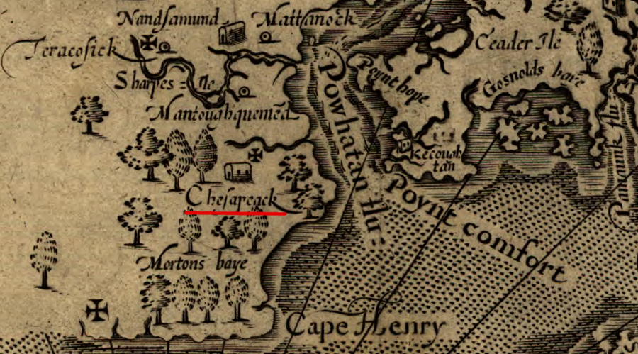
John Smith located the kings house of the Chesapeakes along the Elizabeth River
Source: Library of Congress, Virginia (by John Smith, 1624)
Excavations at Great Neck, on the eastern side of the Eastern Branch of the Lynnhaven River, have revealed what may have been the town of Chesepioc during the 1980's. Bones of 64 people were excavated by the archeologists.
After the US Congress passed the Native American Graves Protection and Repatriation Act, there were no remaining Chesapeake to petition for the remains to be returned from storage and reburied. The Nansemond tribe assumed that responsibility, and the bones were reburied at First Landing State Park.5
the Roanoke colonists discovered the Chesapeakes lived along the Elizabeth and Lynnhaven rivers
Source: Library of Virginia, Alan M. Voorhees Map Collection, Virginia et. Florida (by Gerhard Mercator, 1607)