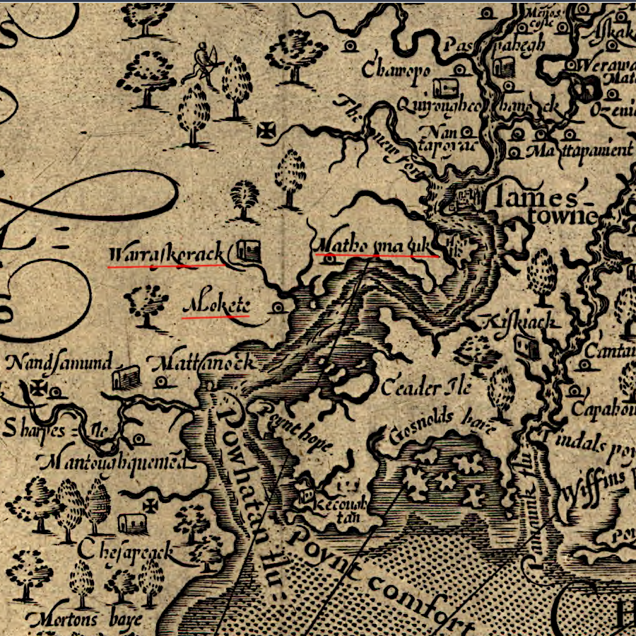
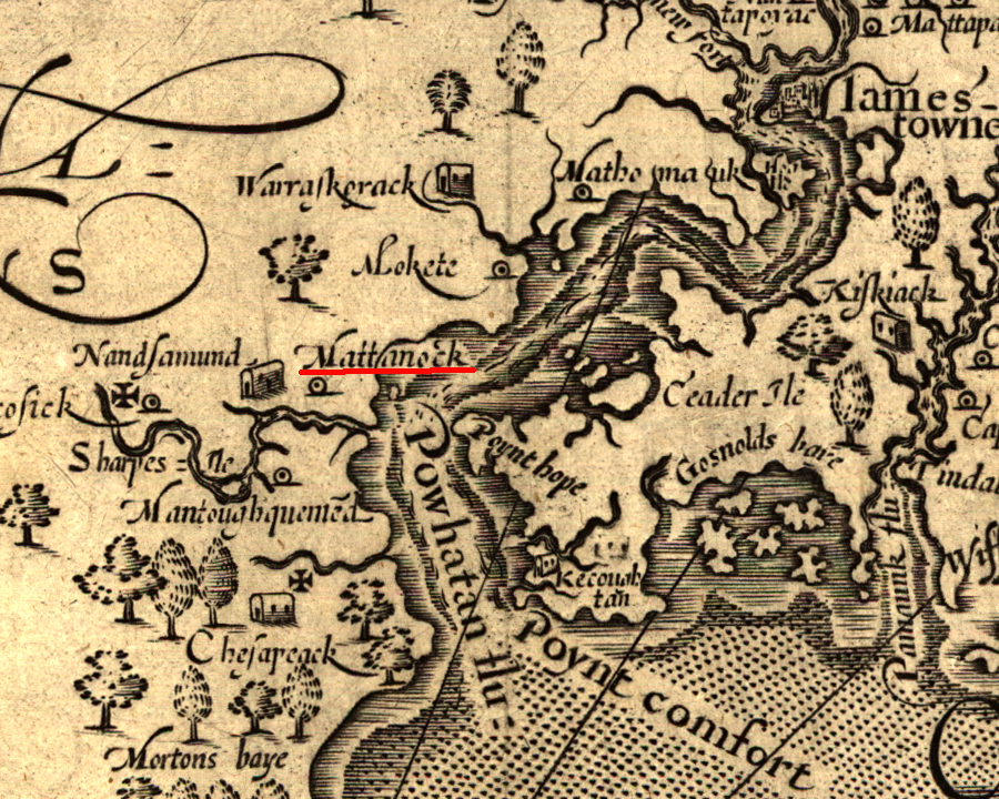
John Smith recorded the location of three Warraskoyak towns centered on the Pagan River
Source: Library of Congress, Virginia (by John Smith, 1624)
John Smith recorded the location of three Warraskoyak towns centered on the Pagan River
Source: Library of Congress, Virginia (by John Smith, 1624)
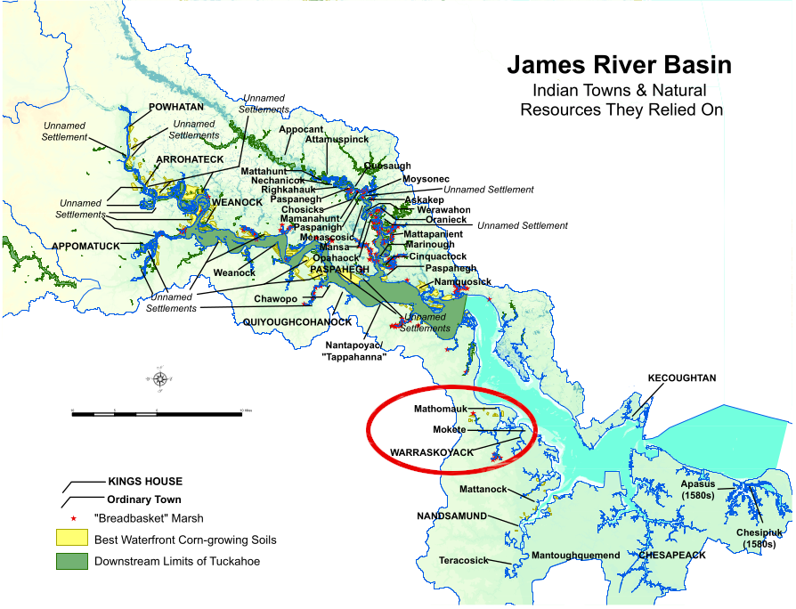
When the English colonists arrived in 1607, they discovered the Warraskoyak living on the south bank of Powhatan's River (which the English renamed after King James). Their main town, mapped by John Smith as the "king's house," was on the Pagan River near the modern town of Smithfield. Two other towns, Mokete and Mathomauk, were located on the south bank of the James River. Between the three towns, Smith recorded that the Warraskoyak had 40 "warriors."1
The Warraskoyak were an Algonquian-speaking tribe in Tsenacommacah. The Warraskoyak weroance, Tackonekintaco, paid tribute to paramount chief Powhatan.
The homeland of the Warraskoyak provided easy access to oysters and fish from the river. It had been occupied for at least 5,500 years. Sea level rise at the end of the last Ice Age drowned the mouth of the Pagan River, and the resulting wetlands were valued food sources for Native Americans long before the evolution of the Warraskoyak tribe.
Inland, across the watershed divide separating the James and Blackwater rivers, hunting and gathering opportunities were rich in what today are labeled Pettit and Belle Meadow pocosins and Pouches, Passenger, and Rattlesnake swamps. In those swamps and woods, the Warraskoyak must have encountered Iroquoian-speaking Nottaway hunters coming up the Blackwater River.
The Algonquian-speaking Quiyoughcohannock lived to their west, upstream on the James River beyond Hog Island. The powerful Algonquian-speaking Nansemond tribe, with 200 warriors according to John Smith, lived downstream on the Nansemond River with a "kings house" on Dumplin Island. The size of the Nansemond tribe would have deterred the Warraskoyak from conflict, if those neighbors chose to hunt near Mokete, Mathomauk, or the king's house of the Warraskoyak.
From those three towns, the Warraskoyak found it easy to canoe out into the James River to trade with the English. They welcomed visitors from Jamestown, bypassing Powhatan with direct trade of food for metal tools and prestige goods. At John Smith's request, they hosted an English boy so he could learn the Algonquian language and facilitate trade and diplomacy.
In early 1608, the Warraskoyak allowed a Paspahegh guide to lead two Jamestown colonists into their territory to search for survivors of the "lost colony" on Roanoke Island. Later that year, they assisted another searcher, Michael Sicklemore, to journey towards the Chowan River on another futile expedition.2
Tackonekintaco also warned John Smith, on his way to Werowocomoco to trade with Powhatan in 1608, that visiting the paramount chief involved great risk:3
Starting in 1619, English colonists established two large settlements in the lands of the Warraskoyak, Basse's Choice and Bennett's Welcome.
Giles Jones was an "ancient" planter who claimed land near the mouth of the Pagan River. Because Jones had arrived before 1618, he was not obligated to "plant" settlers in order to perfect his claim to that land.
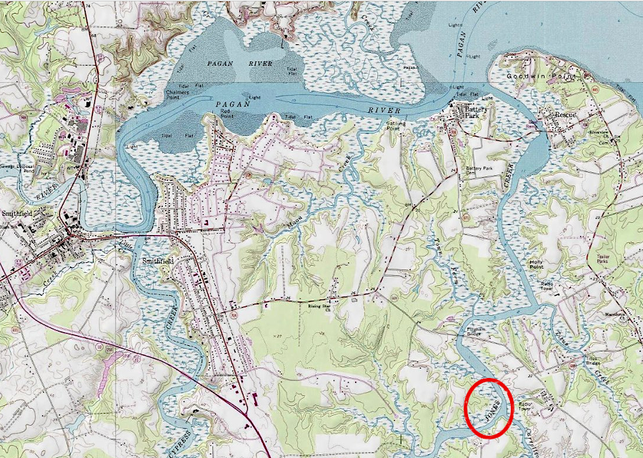
Giles Jones patented land east of the Pagan River, as the English planned to occupy all of the James River waterfront used by the Warraskoyak
Source: ESRI, ArcGIS Online
Captain Christopher Lawne and Lt. Nathaniel Basse partnered to create a new settlement on Warresqueake (now Burrell) Bay, and committed to bring 100 new colonists to Virginia. Lawne arrived with them in April, 1619 on the Marygold, and they started to clear land and built houses at what became Lawne's Creek. Many quickly became sick, the Lawnes Creek Plantation settlement was abandoned, and Christopher Lawne died in November, 1619.
Basse, the other settlers and Lawne's heirs got the patent for that land renewed. They named it the Isle of Wight Plantation and committed to bring 100 more colonists by 1625.
Late in 1621, a London merchant named Edward Bennett got a patent for land downstream of Isle of Wight Plantation that required him to bring 100 people to Virginia. The Sea Flower brought the first recruits in early 1622.
Nathaniel Basse found new investors willing to duplicate the initial plans of Base and Captain Christopher Lawne, for an additional settlement project separate from the Isle of Wight Plantation. Basse's new grant for 300 acres, which he called Basse's Choice, was east (downstream) of the Pagan River.
The various patents for land extended English settlement along all of the James River waterfront which had been territory of the Warraskoyak. The English intentionally planned to displace the Warraskoyak, converting "old fields" used by the tribe to grow corn into tobacco farms without purchasing the Warraskoyak claims to the land or providing any compensation.
Once colonists occupied the patented land, the Native Americans would lose access to the protein-rich food in the river. English hogs and cattle would destroy the unfenced agricultural plots planted by the Warraskoyak. The English pattern of land use made it impossible for continued use of the land by Native Americans.
Not surprisingly, Opechancanough was able to recruit the Warraskoyak to participate in the March 22, 1622 uprising. Over 50 settlers were killed at Bennett's Plantation and Basse's Choice. Basse's house was burned that day.
The English colonists who survived the attack retreated to Jamestown. Governor Yeardley ordered construction of a fort called The Castle at the mouth of the Pagan River. Steady attacks and destruction of corn crops throughout the 1620's forced the Warraskoyak off their lands.
By 1623, Edward Bennett had 33 people living on his land grant, which he renamed Bennett's Welcome. Resettlement included placing four imported Africans on that land.4
60 years after Jamestown was settled, the Warraskoyak presence was still recorded by mapmakers
Source: Library of Congress, Virginia (by John Ferrar, c.1667)
According to tradition, Nathaniel Basse's third son married a member of the Nansemond tribe in 1638. Surviving records suggest that the son died without having children, but many residents in Isle of Wight County with the surname Basse (including members of the Nansemond tribe) suggest they are descendants.5
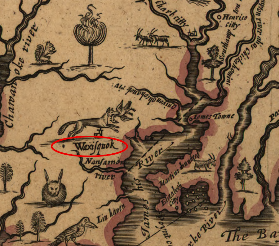
John Smith recorded the location of the Warraskoyak, between Hog Island-Pagan River
Source: National Park Service, Captain John Smith Chesapeake National Historic Trail
Today a group calling itself the Mathomank Village Tribe claims to be descended from inhabitants of the Warraskoyak town at Mathomauk. A resolution introduced in the General Assembly in 2017 to commend the tribe failed to pass, perhaps in part because it included the claims that:6
The group organized as the Rushmere Community Development Corporation. It sought to establish a museum at Tyler (Baileys) Beach, which in the 1960's was an oystering and entertainment district populated by primarily by African-Americans.
The Hughes Heritage and Waterman Conservation Project was an agritourism initiative, a public-private partnership with Isle of Wight and Surry counties, with hopes of obtaining grants to build a fishing pier, marina, and historical interpretation facilities. Included in the initiative were nine landowners whose property was identified as Mathomank Village. The Tyler Beach area was identified as a community with mixed ancestry, highlighting the Native American as well as African-American heritage.
The National Park Service provided a $130,000 grant in 2013-14 to study the proposal. However, the Rushmere Community Development Corporation failed to gain funding from either Surry or Isle of Wight county, and a $6.7 million loan requested from the Communities Facilities program of the U.S. Department of Agriculture was not granted.7
John Smith also documented the Mathomank town at what is now Burrell's Bay
Source: Library of Congress, Virginia (by John Smith, 1624)
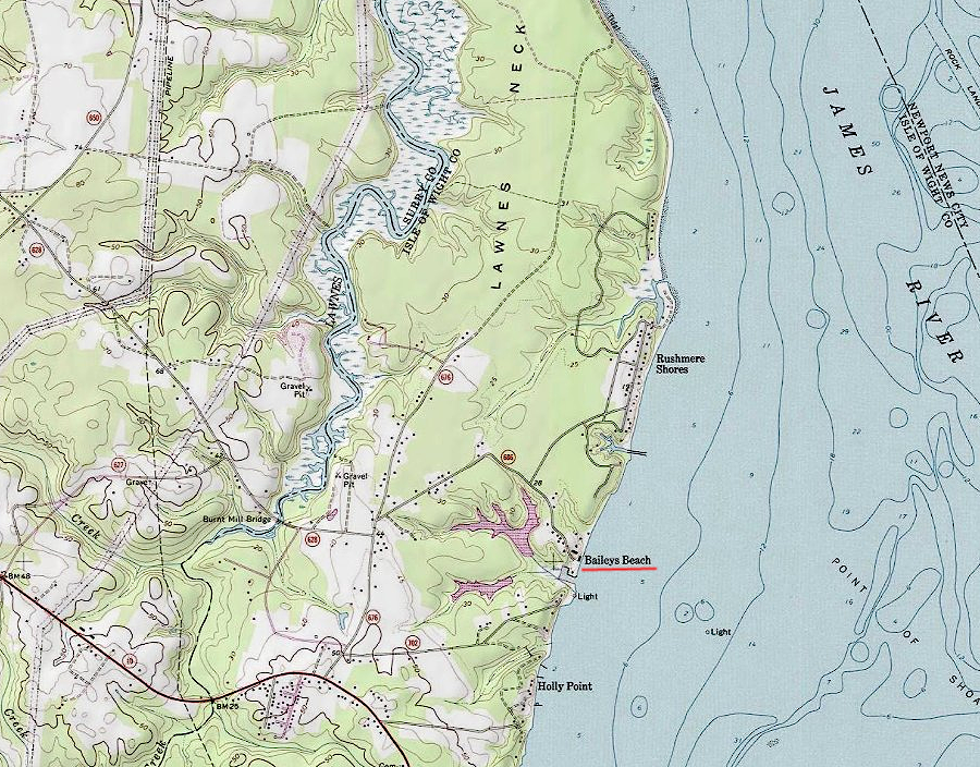
efforts to create a recreation/historical focus highlighting Warraskoyak heritage at Baileys Beach have not attracted the necessary funding
Source: ESRI, ArcGIS Online