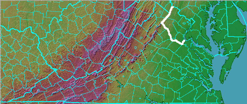
one way to define boundaries of NOVA vs. ROVA
Northern Virginia (NOVA) is different from the Rest of Virginia (ROVA)... but there is no clear consensus on what constitues the boundaries of each region. Over time, the edge of NOVA has crept outwards from Alexandria. Today, few people consider only the political jurisdictions inside the Beltway (I-495) to be part of NOVA.
It's not surprising that regional would be "flexible." After all, how would you define the "Mid-Atlantic states," today. Would you include Pennsylvania? South Carolina? West-by-Gawd Virginia?
Even defining a region in a specific historical time can be so complex, you might choose to just stipluate a few facts so a conversation can just move on. For example, which states joined the Confederacy in 1861? Do you count Kentucky and Tennessee? (The Confederate Congress put 13 stars in their national flag, thus counting those two states.)
How many countries belong to the "free world" today, assuming there is such an alignment? Could you get 10 other people to concur with those boundaries? From the flip side, which countries belong to your non-free world or perhaps "axis of evil" (assuming you think there is such an alignment)?
(Some of us are old enough to remember when the Iron Curtain defined a line on the map separating communist vs. non-communist countries in Europe. Yugoslavia was normally defined on the non-communist side of that line, while Poland was located "behind the Iron Curtain." When President Ford argued in his 1976 election campaign that Poland was not dominated by the Soviet Union, he was roundly criticized... and then the Solidarity movement helped to trigger dramatic sociological change. Twenty years after Ford's comment, the phrase "Iron Curtain" became little more than an item for a Jeopardy game show quiz.)
Socio-economic conditions in the counties of Virginia are no more static than international relationships. In the last century, there has been dramatic changes in Arlington, Fairfax, Loudoun, and Prince William counties, plus the independent cities surrounded by those counties. Most obvious, and easiest to document, are the population changes within the separate counties/cities.
Explore the Historical Census Browser, where you can examine county population statistics and trends between 1790-1960. Check out the Bureau of Census Population of Counties by Decennial Census: 1900 to 1990 file to see more-recent statistics.
Several cautions, in addition to a suggestion that you might be risking eye strain if you try to read the numbers for too long at any one sitting:
- be sure to pay attention to the dates at the top of the columns in the 1960-200 data set, or you might think population in Northern Virginia was declining each decade
- boundaries of jurisdictions have changed, so some substantial population changes between some decades may not represent mass migration
- each census changed the "how to count people" rules of the game, so don't try to perform complicated statistical analyses based on the data... but do notice the trends
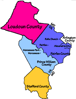
Assume NOVA consists of Alexandria, Arlington, Fairfax, Fairfax City, Falls Church, Fauquier, Fredericksburg, Loudoun, Manassas, Manassas Park, Prince William, and Stafford and the Rest of Virginia (ROVA) consists of the other jurisdictions. You can see dramatic population change in these statistics:
Total population in Virginia in year 2000: 7,078,515
Percentage of Virginia's population in NOVA in year 2000: 28%
Percentage of Virginia's population in ROVA in year 2000: 72%
Total population in Virginia in year 1960: 3,966,949
Percentage of Virginia's population in NOVA in year 1960: 17%
Percentage of Virginia's population in ROVA in year 1960: 83%
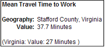
Now explore the Census Bureau's Mean Travel Time to Work calculator for the year 2000. Click on a county, and you can get the statistics for the "average" commute compared to the state average. Those numbers to make sense to you in Northern Virginia, or appear to be too low?
Now look at Where people who live in Prince William County commute to work (and see the map). Do most residents of Prince William County and the independent cities of Manassas and Manassas Park work in the county/cities where they live, or commute to work in another jurisdiction?
In the year 2000, 16,549 people commuted from Prince William, Manassas, and Manassas Park, VA to the District of Columbia. 10,884 commuted to Arlington, while 56,124 commuted to Fairfax... and 68,893 had a shorter commute to jobs in the same jurisdictions (Prince William, Manassas, and Manassas Park) where they lived.
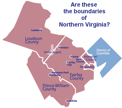
Using these patterns and looking at the following jurisdictions, can you determine the edge of Northern Virginia - or at least the edge where people quit trying to commute to DC?
Finish by examining the boundaries and background information regarding the Northern Virginia Regional Commission. This organization was established right after World War Two, when it was clear that regional planning could increase cost-effectiveness of wastewater treatment facilities, jails, roads, and other public infrastructure. Planning districts were not established for all regions of the state until the late 1960's,
(What is the most expensive service provided by local governments? Virginia has never mandated cross-boundary consolidation of that service: local school systems, maintained separately in most cases by counties and independent cities. In 1972, when desegrgation was still an intense political issue, Federal District Judge Robert Merhige Jr. tried to force cross-boundary busing of students between urban and suburban school districts in Richmond. White parents had moved their families from the city to the suburbs, as integration occurred in city schools. Through his busing order, the judge was trying to counter de facto segregation triggered by this "white flight" across jurisdictional boundaries. Ultimately, the Supreme Court ruled that judges could not force jurisdictions to share school systems in order to remedy past segregation.)