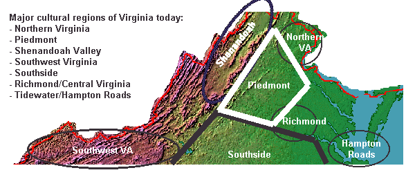
one way to define regions of Virginia
1) look at one way to define the boundaries of Northern Virginia (NOVA) from the Rest of Virginia (ROVA):
- shaded relief map of Virginia
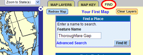
- use the National Atlas to examine Thoroughfare Gap (HINT: Go to the FIND tab and search for Thoroughfare Gap, which the US Geological Survey says is located in Fauquier County)
When you drove I-66 west through the Bull Run Mountains, you may have noticed the ruins of the Chapman (Beverley) Mill on the northern side. Did you know Millbrook Quarry was located on the southern side? Look at an aerial photo or the topographic map. You can see the quarry is now filled with water, and it is a popular training site for scuba divers. This quarry excavated red/purple sandstone for building stone, not black diabase rock for road asphalt.
- use Terraserver to examine the Fall Line at Occoquan and Fredericksburg
- at Occoquan, use the Urban Area photo to find the Graham quarry, excavating 400-million year old granite just upstream from the town of Occoquan, near the dam that backs up the Occoquan Reservoir (the photo was taken before Fairfax Water built a new drinking water treatment plant on Route 123, opposite the former Lorton Prison)
- at Fredericksburg, look on the now-outdated aerial photo showing Embrey Dam, used to provide waterpower to industries in the city until its removal in 2004
2) Now use Google Earth to explore the same places. If not already installed on your computer, you'll have to download it. (Think the extra capabilities in Google Earth are worth the hassles of downloading and learning this tool?)
3) Modern jurisdictions in NOVA vs. ROVA, and follow the links to these sites:
- Historical Census Browser
- Population of Counties by Decennial Census: 1900 to 1990
- Mean Travel Time to Work
- Where people who live in Prince William County commute to work and map
- Arlington County (see map)
- Fairfax County/Fairfax City/Falls Church (see Fairfax County map, Fairfax City map, and Falls Church map)
- Fauquier County (see map)
- Culpeper County (see map)
- Orange County (see map)
- Rappahannock County (see map)
- boundaries
- background information
 4) boundaries of the original settlers in Northern Virginia, and follow the links to these sites:
- Potomac Creek pottery
- image of a 1500's town
- John Smith's map of Virginia
- How the Fall Line Shaped Powhatan's Empire
- Native Americans of the area
- Becoming a Homeplace
- Native Americans in Northern Virginia
- We Have a Story to Tell: Native Peoples of the Chesapeake Region (pages 6-14)
5) Virginia-Maryland Boundary, and follow the links to these sites:
- charter
- 1796 Map of the States of Maryland and Delaware
- Compact of 1785
- DC, Maryland or Virginia? The Formation of the District of Columbia and its Shifting Boundaries
6) The Claiborne Connection (Virginia and Maryland have not always been friendly...)
7) Virginia-District of Columbia Boundary, and follow this link:
- History of the Original Boundary of the District of Columbia
- Boundary Stones of the District of Columbia
8) Library of Congress Maps (zoom in and explore)
- Birds eye view of Alexandria, Va.
- Perspective view of northwest Alexandria: showing location with reference to cities of Washington & Alexandria
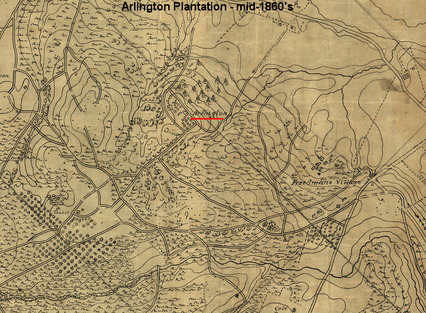
- Detailed map of part of Virginia from Alexandria to the Potomac River above Washington, D.C. 186- (can you see the road pattern around Fort Meyer (and the Lee-Custis Mansion house now in Arlington Cemetery) in this Civil War-era map?
9) How Counties Got Started in Virginia
10) Town and City Boundaries and Annexation
11) Alexandria/Arlington:
- Alexandria
- Alexandria's City Hall
- Arlington Historical Society: Alexandria County, District of Columbia
- Arlington Historical Society: Suburban Alexandria County
- see also City of Fairfax history
12) Newberry Library - Atlas of Historical County Boundaries
- as population grew, county seats (where all real estate tranasctions were recorded) became too distant from the shifting population. To keep county seats within a half-day's ride for most residents, the seats were either moved or the county boundaries were adjusted. To see the changing county boundariers, set month/day on the map as December 31, then look at Northern Virginia boundary changes in:
- 1634, when counties were first created
- 1664, when Stafford County was created from Westmoreland County
- 1721, when Fredericksburg was created (not shown on this small-scale map)
- 1731, when Prince William County was carved out of Stafford/King George counties
- 1742, when Fairfax County was carved out of Prince William County
- 1757, when Loudoun County was carved out of Fairfax County
- 1759, when Fauquier County was carved out of Prince William County
- 1800, when a portion if Fairfax County became part of the District of Columbia (map shows the boundar change starting in 1791...)
- 1849, when Alexandria County (called Arlington County since 1920) was revested to Virginia
- and read Virginia and West Virginia Commentary for some of the complexity in mapping these boundaries
13) The Migrating Courthouse and Shifting Boundaries of Fairfax County
- The Debates over the Retrocession of the District of Columbia, 1801-2004
14) Civil War (the beginning of NOVA being viewed as "occupied Virginia"):
- On to Richmond in 1861
- Alexandria's terse Civil War summary
- Alexandria's more-loquacious Voices from the Past, Alexandria, Virginia 1861-1865
- If you adopt the Union perspective on the Civil War and the official role of the Restored Government of Virginia, the capital of Virginia officially shifted to Wheeling in 1861 after the Confederate leaders in the state held a convention, and then an election in which voters approved secession from the Union. The state capital moved again in 1863 to Alexandria, after West Virginia joined the Union as an independent state. The last move was back to Richmond in 1865, after the defeat of the Confederate armies and the dissolution of the Confederate government.
- However, to agree that the capital moved from Richmond to Wheeling an d then Alexandria, you have to assume secession was unconstitutional and Virginia never had the authority to withdraw from the Union. That was President Lincoln's approach, and it would have permitted the executive branch to manage Reconstruction. The Congressional perspective was different: the states had to be re-admitted to the national union by the Congress. During Reconstruction, the state government was not elected, but instead was appointed by Federal officials. Northern Virginia was part of Military District #1 until Virginia was re-admitted to the Union in 1870.