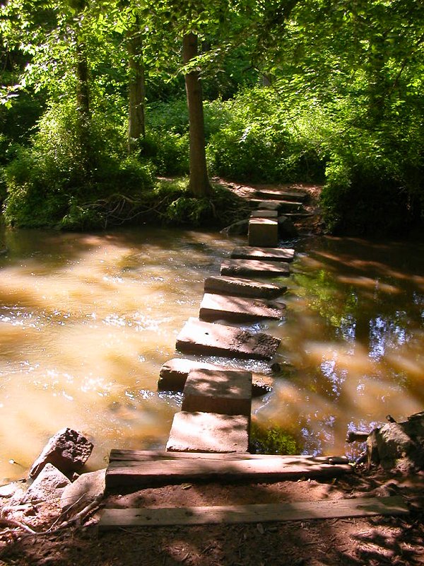
modern foot crossing of Big Rocky Run at Eleanor Lawrence Park, near Centreville
modern foot crossing of Big Rocky Run at Eleanor Lawrence Park, near Centreville
 The very first human residents of Northern Virginia walked everywhere for perhaps 10-15,000 years. They created a network of paths, where they travelled regularly from their towns to good territories for hunting and fishing and gathering of wild foods. Paths also connected their villages, located near good drinking water and agricultural land and the easy fords across the rivers.
You don't need much imagination to assume that the first Virginians made trails through the woods to all the convenient places for crossing ("fording") creeks. Animals would have used the same routes, and the Native Americans may have improved a few deer trails when they started farming in this area about 3-4,000 years ago. Places with names such as Balls Ford Road have a long heritage, one that starts before the land was purchased by the Ball family.
In 1812, Spencer Ball purchased 762 acres west of Bull Run, where the visitor center on westbound I-66 now stands, from his brother-in-law George Carter. Spencer Ball's plantation house, Portici, was located on the hill north of I-66 and just east of the tall, unmarked computer data center at the edge of Battlefield Business Park.
Portici burned during the Second Manassas battle in 1862. George Carter's estate, Oatlands in Loudoun County, gives visitors a sense of how modern McMansions make the "big plantation houses" of the 1800's look very... small.
Virginia's first residents could have arrived here from the Solutria region of France, rowing along the edge of the ice sheets south of Greenland. Even if the first residents migrated north from the Gulf of Mexico, odds are good that the Native Americans used boats from the first days of their arrival.
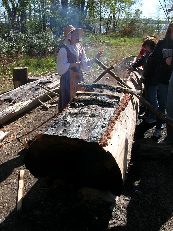
When John Smith rowed/sailed up the Potomac River in 1608, Native Americans were carving their canoes from trees using stone and bone tools, plus fire. Modern re-enactors can create a canoe by these techniques in about a week, and John Smith reported seeing fleets of canoes when he explored the rivers of Virginia.

making canoes with stone and fire
Source: Theodore De Bry Copper Plate Engravings
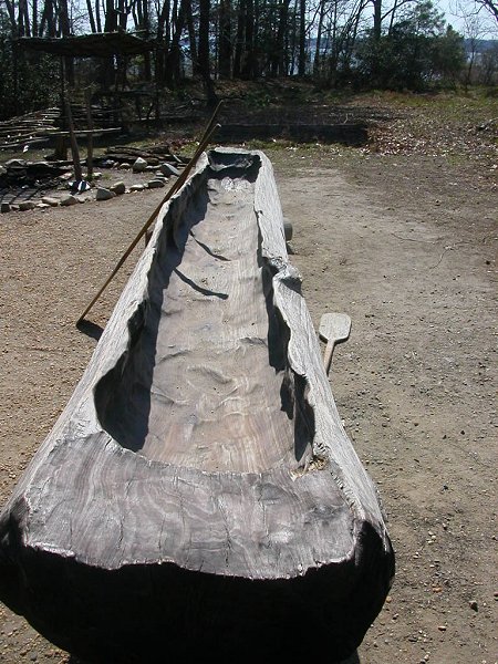
Native Americans did not go out into the woods and select a tall straight tree, then cut it down and carved it into a canoe. They used a tree already washed into the river, or on the river's edge. The Native Americans had no mules or horses to drag trees/finished canoes to the riverbank. Those living west of the Fall Line, away from large rivers, would not have created any canoes.
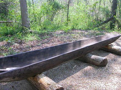
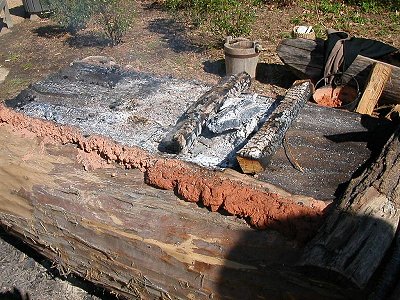
canoe carved from tree trunk (Henricus Historical Park) and using fire in center while protecting edge with mud (Jamestown Festival Park)
To carve a canoe, hot coals would be placed on the section of tree to be removed. Charring the wood made it easier to scrape away. But how did the canoe makers avoid burning sections of tree trunk that were not to be removed?
Mud, good ol' Virginia mud. Mud was plastered on the edges of the trunk, ensuring that only the sections intended to be removed would burn. A thick layer would be slathered carefully on the edge of the tree trunk, and it would stop the fire from weakening the portion of wood that was being retained.
Europeans who settled Northern Virginia after 1650's had other construction techniques for boats
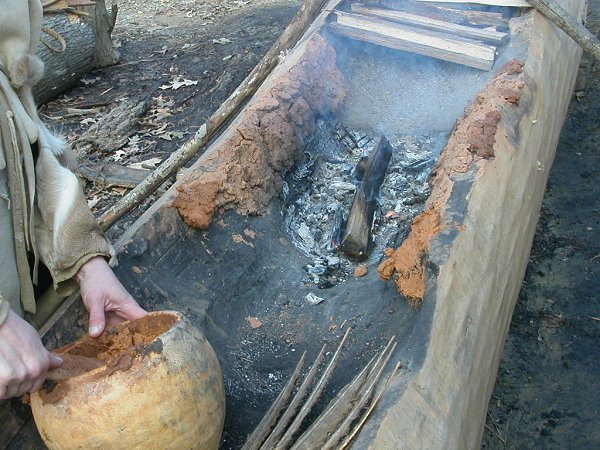
Hand-carved canoe at Jamestown, made by burning the wood in the center and scraping the charred wood with bone and stone tools - protecting the edges with mud, so they did not burn
The Europeans who grew tobacco in Northern Virginia had better technology for their ships - and relied upon it. Tobacco had minimal value in Virginia; it had to be shipped it to Europe for sale. Tobacco was a cash crop (sold for cash), not a food crop that could be used in the colonies. In the colonial era, the customers with cash were in France, Spain, and England.
That's one major reason why earliest settlers patented lands along the rivers. The rich soil in the flat bottomland was a major attractioon, but crops grown on the shore of the Potomac River required far less effort to drag to a ship that could cross the Atlantic Ocean.
Even for personal travel, colonists relied most heavily upon the rivers for long-distance trips. Transportation by water was traditional in England, and the ability to build boats was demonstrated when the convoy carrying the governor to Virginia in 1609 was shipwrecked at Bermuda. The sailors and passengers built two new boats from the wreckage, and Shakespeare incorporated the story into his play "The Tempest."
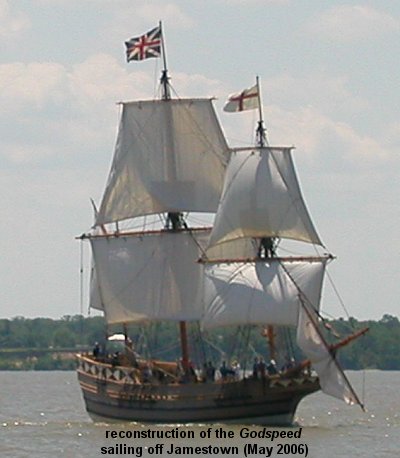
1607 English sailing ship (modern re-creation, at Jamestown)
Once the waterfront property was patented in the 1650's-1670's in Northern Virginia, the plantation owners required roads to transport large barrels (hogsheads) of tobacco to wharves on the Potomac River for export to Europe. Anyone rolling such barrels, sometimes weighing over 1,000 pounds, would have followed the easiest routes: the existing trails. The driest trails between the Chesapeake shoreline and the Fall Line would have followed the low ridges, the watershed divides separating the creeks that drain into the Potomac River.
Most road traffic in colonial Northern Virginia was local, and the beneficiaries of the good roads were the ones required to maintain them. County courts (predecessor to modern Boards of County Suprervisors) required local residents to perform road maintenance. Only a few stretches and bridges were financed through county taxes, rather than mandated labor. When necessary, the county court would issue road orders directing local residents to survey routes and make repairs, such as this one in Fairfax County on September 28, 1749: "Jeremiah Bronaugh and John Graham Gent. are appointed and desired to View the Road and mark out the most convenient way from Pohick Run to Occoquan Ferry and make their report to the next Court."
In 1662, about the time Stafford County was created, the General Assembly in Jamestown required that all roads be 40 feet wide. The horses and wagons of the 17th Century were not speeding down the highway, needing 40-foot wide roads to pass each other safely. That 40-foot width included the ditches needed to keep a roadbed dry in the days before pavement. Most colonial roads were about the width of just one wagon.
modern Thoroughfare Road, west of Haymarket... and about 20 feet wide