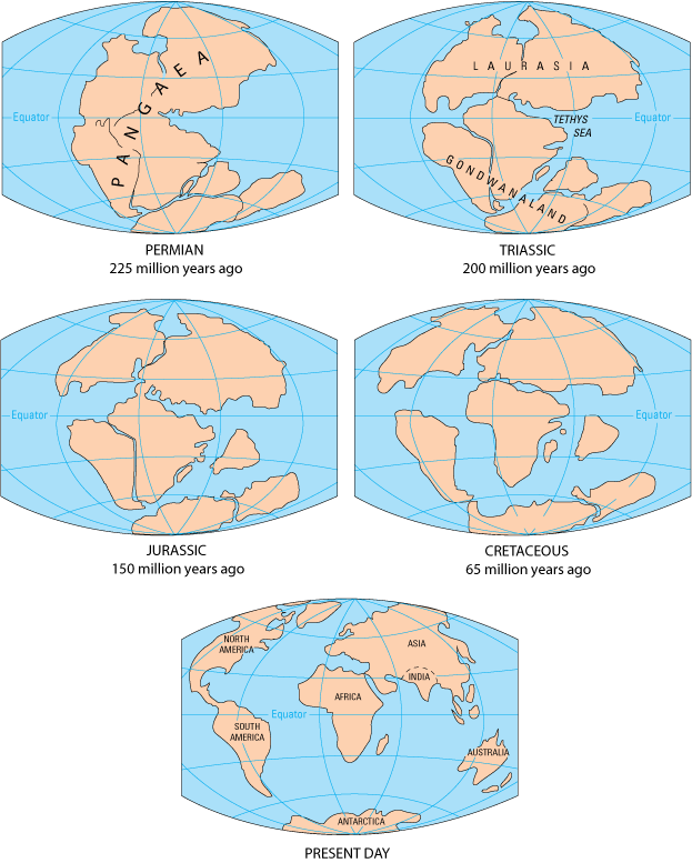
breakup of Pangea
Source: USGS This Dynamic Earth
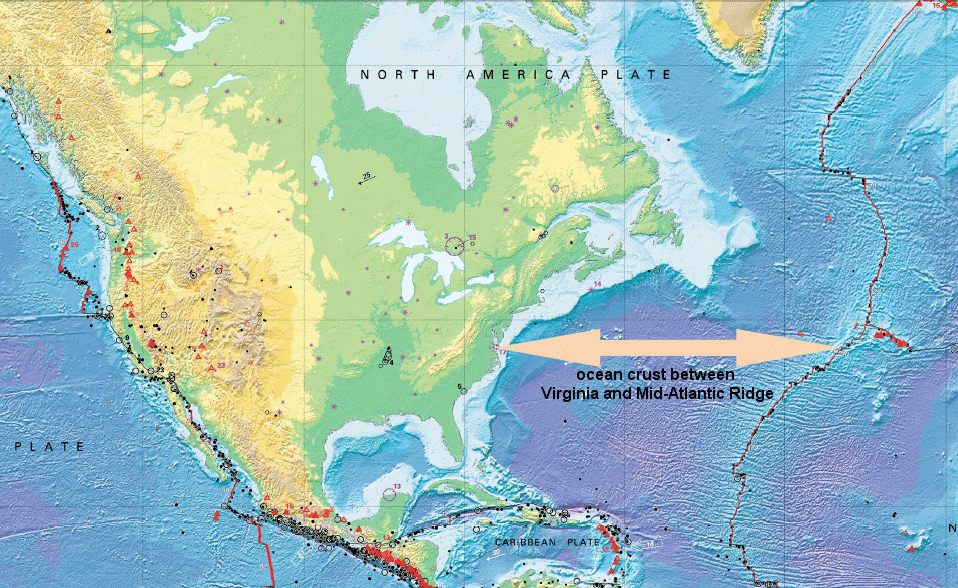
Northern Virginia is moving towards China. The North American continent is drifting west, away from the lava flowing out of the Mid-Atlantic Ridge, by about one inch every year. Since Europe is moving away from the Mid-Atlantic Ridge at the same rate, the Atlantic Ocean is growing wider by almost two inches/year. That speed is slightly faster than the rate at which fingernails grow, and about one-third to one-half of the speed at which human hair grows.1
If someone lives to be 75 years old, during that lifetime Virginia and Europe will have moved 12' further apart.
How did the rocks of Northern Virginia get here, and why are they headed west towards China? That continental drift has been underway for over 200 million years.
breakup of Pangea
Source: USGS This Dynamic Earth
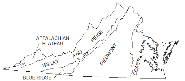
The bedrock of Northern Virginia has three main stories to tell, organized by areas known as "physiographic provinces" because they share similar geological characteristics: the Blue Ridge, the Piedmont, and the Coastal Plain. (The Triassic Basin is a subunit of the Piedmont physiographic province, and has its own sub-story.)
physiographic provinces in Virginia
Source: USGS Ground-Water Dating To Assess Aquifer Susceptibility
The key points:
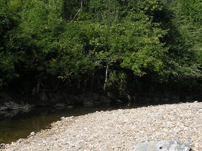
gravel and cobbles, formed as bedrock erodes in Arlington on Four Mile Run at Barcroft Bog (ultimately minerals will dissolve, and quartz grains will form sandy beaches downstream)
Triassic-Jurassic sedimentary rocks form the purple-red sandstone sediments in the Culpeper Basin. The red color shows magma that formed diabase, the hard rock that is quarried today
Source: Virginia Department of Mines, Minerals and Energy Generalized Geologic Map of Virginia
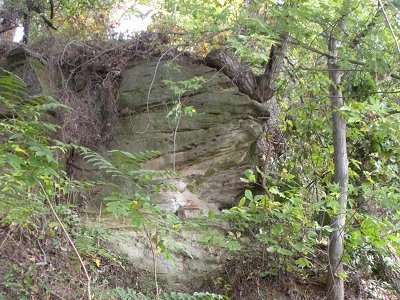
If you define Northern Virginia to include Fauquier and Loudoun counties, then the Blue Ridge mountains forms the western edge of the region. The core of the Blue Ridge is a granite that is over 1 billion years old. That billion-year old rock is coated by a 600-million year old layer of lava. As you drive east from the Shenandoah Valley on I-66 through Fauquier County, all the outcrops of bedrock in the pastures will be the 600-million year old dark lava.
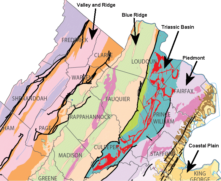
At Thoroughfare Gap, still headed east on I-66, you enter one of the Triassic Period basins in the Piedmont physiographic province. That basin formed when Africa and North America cracked apart, and the Atlantic Ocean developed between the continents. As North America and Africa pulled away from each other, the crust of the earth stretched and cracked. One fault formed at the edge of the Blue Ridge, and there the land dropped down like a trap door with the hinge at Centreville. Today, there is an obvious valley between Thoroughfare Gap and Centreville that marks the location of the Culpeper (or Manassas) basin.
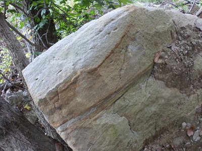
Triassic sediments tilting down to the west (exposed at Luck Stone quarry near Bull Run)
The basin filled with sands and other sediments so rich in oxidized iron that they are distinctively purple when exposed at modern construction sites. At places, the purple sandstones are interrupted by black volcanic rock that rose up (as the crust on the surface thinned and cracks widened) from the molten magma below. Nearly all quarries in the Piedmont province are located where the volcanic rock (diabase or "traprock") is exposed. The purplish sandstone is too soft for use in road construction, but the hard volcanic rock is highly valued for use in roads, building foundations, concrete, and other construction materials.
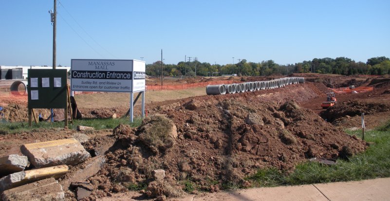
purple/red Triassic sediments exposed at Manassas Mall during Super WalMart construction
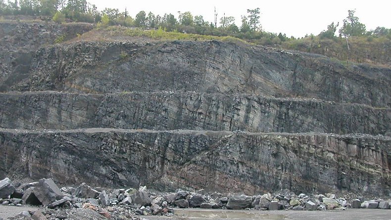
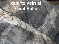
East of Centreville to Interstate 95, you will cross a different segment of the Piedmont physiographic province. Here, construction projects will expose orange/yellow bedrock that is easily broken up by bulldozers without requiring any blasting. On the eastern edge of this province, waterfalls are exposed where rivers have etched through the weathered "saprolite" to a hard bedrock. A series of waterfalls between Baltimore (Maryland) to Augusta (Georgia) is known as the Fall Line; Georgetown, Occoquan, and Fredericksburg mark the location of the Fall Line in Northern Virginia. The bedrock at Great Falls was exposed about 30,000 years ago, when Ice Age erosion stripped off the overlying materials.
This portion of the Piedmont, now far from the Atlantic Ocean shoreline, was once a series of ocean sediment layers. The sediments ended up buried deep under a chain (arc) of islands off the coastline of Virginia, and then were "smushed" against the Blue Ridge when continents collided about 400-200 million years ago.
In that process, the sediments were metamorphosed by the weight of miles of overlying rock. Distinctive minerals formed under heat and pressure indicate the rock now exposed at Great Falls was 15 miles deep underground. Further east in Mather Gorge, downstream near the mouth of Difficult Run, the rock was buried about 20 miles deep and almost melted completely.
Near Interstate 95 and eastward to the Atlantic Ocean is the Coastal Plain physiographic province. It consists of sediments that eroded off the Appalachian Mountains, plus a few marine deposits when sea levels were so high that the Atlantic Ocean shoreline was roughly the location of I-95. Those eroded sediments from the mountains were deposited east of the modern Blue Ridge, but the western edge of the deposits (between I-95 and the Blue Ridge) has been washed away again. Today, we see only the sediments deposited/re-deposited on the current Coastal Plain since the Cretaceous Period, 145 million years ago.
Those sedimentary layers are still horizontal because there have been no continental collisions to push them up on their side, since North America and Africa began to drift apart. In the soft sediments at the edge of the Piedmont and Coastal Plain physiographic provinces, the erosive energy of the rivers is able to carve deep, so hard Piedmont rocks are exposed as the bedrock forming a line of waterfalls at the eastern edge of the Piedmont/western edge of the Coastal Plain.
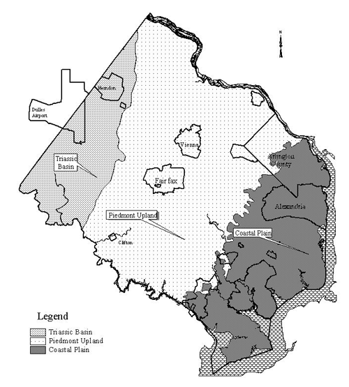
physiographic provinces in Fairfax County
Source: Fairfax County, Ratings of Soils for Urban Development in Fairfax County
Sediments now exposed at the top of the Coastal Plain were never buried deep, so the sand and gravel is only loosely consolidated into rock. Today, gravel pits along the Rappahannock River downstream of Fredericksburg supply aggregate and sand for concrete and asphalt used in local construction projects.
In Stafford County, the soft Aquia sandstone at Governor's Island was quarried in the 1790's to use as building stone in the Capital and President's House now known as the White House, after the stone was painted to help prevent the soft stone from decaying. At what is now Leesylvania State Park, sandstone was so easy to carve from the cliffs that the area became known as Freestone Point.
Freestone Point sedimentary layers and soft sandstone at Leesylvania State Park
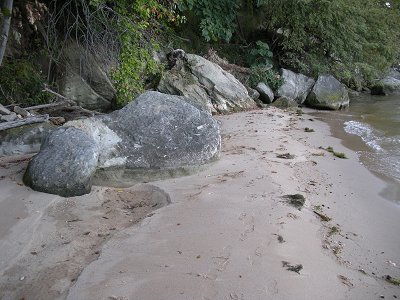
sandstone at Leesylvania, eroding back into individual sand grains
Starting at the Beginning...
Northern Virginia, like the rest of the planet, condensed into a planet about 4.5 billion years ago. As the earth cooled, most of the heavy elements such as iron and nickel sank to the center of the planet, leaving lighter elements such as silicon and calcium in a crust near the surface.
Below the crust is the hot "mantle" rock, occupying the space between the crust at the surface and the iron/nickel core of the earth at the center. The crust (called "lithosphere," if you prefer multisyllabic words) is formed of lighter elements than the mantle, and the elements in the crust are not mixed evenly. About 5% of the crust is still iron - it did not all sink to the center.
Some rocks on the crust have lots of iron, other rocks are rich in calcium and poor in iron, and yet other rocks have lots of silica but little calcium or iron. Mineral composition of bedrock has a strong effect (together with climate) on what vegetation will grow at a particular location. Mines are usually located where a certain mineral is concentrated. For example, a 30-mile wide zone of gold-bearing quartz is located between Montgomery County (Maryland) and Orange County (Virginia). Monroe Park at Goldvein (Fauquier County) commemorates the heritage of gold mining in Northern Virginia.
The thickness of the crust varies between 3-30 miles in different places. Oceans typically have a thin crust formed primarily of iron-rich basalt rocks. Continents are composed of a thicker crust, composed of lighter silica-rich rocks
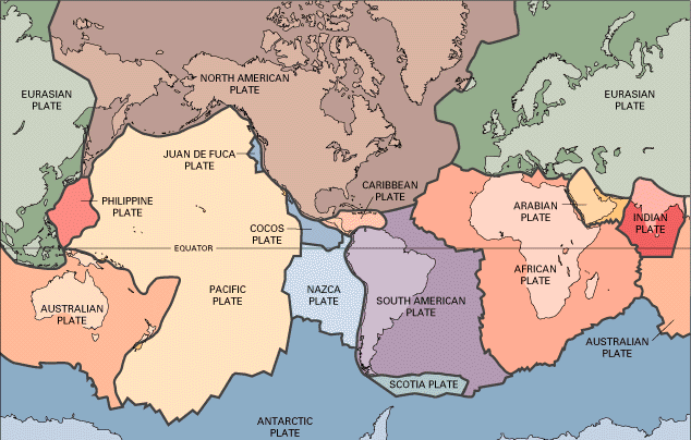
crustal plates (note how Atlantic Ocean seafloor is split in middle between separate plates)
Source: US Geological Survey, This Dynamic Earth
The crust is broken into a dozen or so different plates, which can include both ocean and continental crust. Northern Virginia is near the eastern edge of the continent, but sits in the middle of the North American Plate. That plate stretches from the Mid-Atlantic Ridge in the middle of the Atlantic Ocean to the edge of the Pacific Ocean on the West Coast.
Virginia - in the middle of the North American Plate
Source: US Geological Survey, This Dynamic Earth
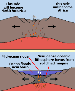
Magma still erupts/oozes from the mantle and reaches the surface of the earth at "spreading centers" that form ocean ridges. At those ridges the magma cools into solid rock, and becomes oceanic crust (rich in iron/magnesium, but also including plenty of silica).
The cooled crust is pushed away from the ridge as more magma emerges at the spreading center, widening the Atlantic Ocean and forming more ocean basalt seafloor (part of the "lithosphere"). In the process, the new rock emerging at the Mid-Atlantic Ridge is forcing Virginia towards China. In 75 million or so years... watch out.
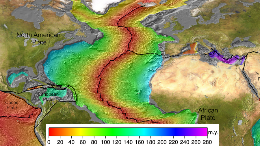
The basalt that forms the floor of the Atlantic Ocean, from the east coast of Maryland/Virginia to the coastline of France/Spain, is not all the same age.
That ocean bottom basalt just east of Ocean City, Maryland solidified into its current form about 150-200 million years ago. The ocean bottom basalt at the Mid-Atlantic Ridge, at the eastern edge of the North American Plate, could have cooled just minutes ago.
Why the age difference? Molten, iron-rich basaltic rock is emerging (from perhaps as far down as the mantle) at the Mid-Atlantic Ridge, where it solidifies. As more molten rock emerges from the crack in the ocean floor, the recently-cooled solid rock is pushed to the side. The engine pushing Northern Virginia towards China is the push from the Mid-Atlantic Ridge.
formation of mid-ocean ridge
Source: US Geological Survey (USGS), The Breakup of Pangea
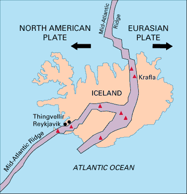
Most of the Mid-Atlantic Ridge is under the surface of the Atlantic Ocean, but Iceland straddles the ridge. The western part of Iceland is part of the North American Plate, while the eastern half is part of the plate with Europe. In the middle of Iceland is the Mid-Atlantic Ridge. The geothermal heating systems of that country tap into the same heat source that is pushing Northern Virginia towards China, and driving continental plates to drift all over the earth.
bedrock in Iceland is much younger than in Virginia
US Geological Survey (USGS), This Dynamic Earth
Only half of Iceland is being pushed westward towards China. That half is traveling west together with the half of the bottom of the Atlantic Ocean - the half between Iceland and North America - plus the North American continent itself. Remember, that part of the ocean floor and the North American continent are joined together in one "plate" that essentially floats on the molten mantle underneath the crust. The western edge of the North American Plate is at the Pacific Ocean coastline of Washington, Oregon, and California. (A portion of California, on the west side of the San Andreas fault, actually belongs to a different plate.)
When ocean plates collide, one is pushed down ("subducted") into the deeper mantle. When a plate of ocean rock runs into a plate of continental rock, the heavier oceanic crust (with a higher percentage of iron/magnesium) is typically pushed underneath the lighter continental plate. After the edge of the ocean crust is pushed deep, it melts. Hot liquid magma from melted crust often rises up to erupt in a chain of volcanoes, such as the Cascade Mountains in western Oregon/Washington.
Lighter minerals such as silica (quartz) melt at a lower temperature and are separated from other rock rich in iron/magnesium. As volcanoes erupt, the silica-rich rocks emerge on the surface first and are concentrated into continents (Africa, South America, Australia, etc.) that will keep growing larger as more crust is "fractionated" through melting. Think of these continents as Cheerios floating in a bowl of milk, bouncing together as the molten rock currents swirl below in the mantle beneath the crust.
No Northern Virginia rocks are 4.5 billion years old, when the crust first formed. All of the rocks in Northern Virginia have been remelted and recycled through the subduction/melting/eruption process (or at least eroded and reconstituted as new sedimentary/metamorphic/igneous rocks) at least once.
The oldest rocks in the Blue Ridge on the western edge of Northern Virginia are the Pedlar and Old Rag granites, about 1.1 billion years old. East of the Blue Ridge and north of the Rappahannock River, our oldest rocks cooled into their current solid form "only" about 450 million years ago. The seafloor of the Atlantic Ocean, the Continental Shelf off the Virginia coastline, is about 180 million years old. The oldest seafloor on earth is underneath the Mediterranean Sea, where the African Plate has not yet collided with Europe.2
the seafloor is far younger than continental crust, since it is recycled more often by subduction
Source: National Oceanic and Atmospheric Administration (NOAA), Age of the Seafloor (vegetation)