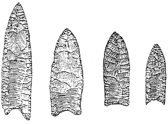
Clovis points, with distinctive "flute" etched out in the center starting at the bottom
Humans did not originate in Northern Virginia. We are all immigrants. Some of us belong to families that arrived earlier than others, but the species of Homo sapiens originated in Africa and then migrated to Northern Virginia.
We have found evidence of the first Northern Virginians from about 11,000 years ago, but people may have arrived even 5-10,000 of years earlier. Those first residents of our area might have paddled here from Southern France, bringing their Solutrean culture with stone tools closely resembling the early Clovis artifacts found in North America.
Clovis points, with distinctive "flute" etched out in the center starting at the bottom
However, the conventional wisdom still says the first Northern Virginians arrived from Siberia, as one or more hunting parties followed mammoths and other big game eastward. Hunting bands travelled across icy marshes that were exposed during a period of low sea levels, when water was trapped in glaciers during the last Ice Age. Ultimately one or more bands of hunters/gatherers arrived here.
The place looked different back then. When sea levels low, there was no Chesapeake Bay. What some group of Native Americans ultimately named the Potomac (or Potowomack) River flowed further east to join the Susquehanna River, which then flowed to the Atlantic Ocean. About 5,000 years ago, the valley of the Susquehanna River was been flooded and the Chesapeake Bay emerged.
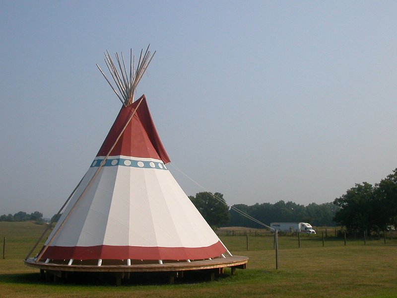
re-creation of skin-based teepee
There are no natural caves in Northern Virginia, so the first settlers had to build their own shelters. What do you think those first settlers used to build their houses? The stereotypes of Native Americans presumes they all lived in teepees made from deerskins and rode horses when the English arrived in 1607.
However, modern horses were not introduced to North America until after the arrival of Europeans. Also, there is no evidence that the original residents of Virginia manufactured teepees. You may find rings of stones, used to hold down the bottom of the skins, on the plains of Montana - but not in Virginia.
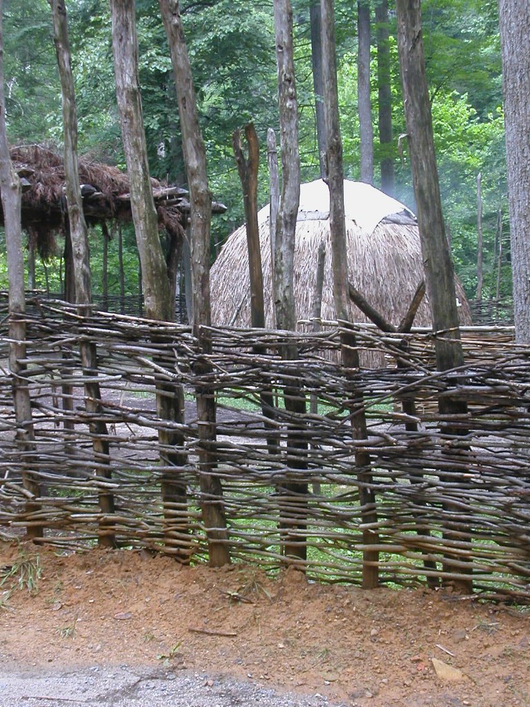
By the time the Europeans arrived, we know that Northern Virginians used reeds (such as cattails) and bark to make the first subdivisions of round or oblong homes.
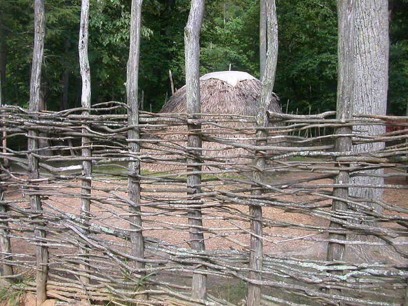
re-creation of reed-based housing
We can use artifacts to also trace some of the tribal relationships between Northern Virginia settlers, long before the first European (John Smith) rowed/sailed up the Potomac River to Little Falls in 1608. Archeologists have used their observation and critical thinking skills to identify unique types of pottery and stone "points" (including arrowheads, scrapers, spear points, and other tools) to identify different Native American cultures. Someday in the distant future, archeologists will excavate places in Northern Virginia. They may date eras by the Time of Filter Cigarettes (filters are very resistant to decay, and can be associated with 20th-Century sites) or the Time of the iPod (presumably that will be a shorter time period).
Look at the detailed description of Potomac Creek pottery. Archeologists excavating sites in our region can identify a time when that style of clay manufacture developed. A change in cultural patterns suggests the arrival of another band of Native Americans, with different skills, at that site.
The first settlers had boundaries for farming plots and houses:1)
Each Native American town sought to control a certain swath of territory. There are no records, written by Native Americans, that document how the earliest Northern Virginia families/tribes determined those boundaries. There are no minutes of anything like a county court or a Home Owners Association generated by the tribes. Do you think it is safe to assume that some aspects of human nature exist in all cultures, including a desire for personal space and control over the resources needed for survival?
The historical record of our region, dating back to 1608, documents that villages were surrounded by palisades. These wooden walls were manufactured by placing tree trunks or smaller sticks into trenches or holes, creating a barrier that blocked an enemy from rushing in and surprising the residents in a Native American town.
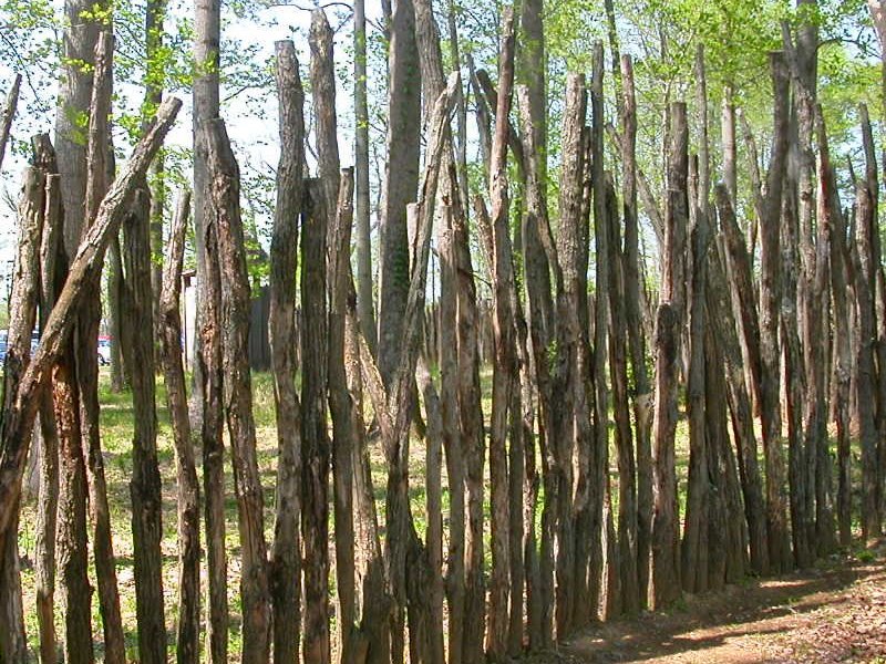
re-creation of palisade
Compare the recreated palisades in earlier pictures on this page to the image of a 1500's town (originally drawn by a member of the famous "Lost Colony" in North Carolina).
What is not clear is whether the Native Americans sought to create a tight barrier, or if they would have left spaces between the logs/sticks in the palisade. Maintenance of a tight palisade would have required more labor, and would have trapped the residents inside the barrier. A loose palisade, with gaps between the vertical members (and perhaps no vines weaving the sticks together) would have slowed an attack less successfully - but would have also allowed some residents to escape out the back side of the town.
But it is clear that the first settlers in Northern Virginia were not living in peace and harmony in 1608, when we get our first written records from John Smith. Those palisades would have been a major public works project for people who had only stone and bone tools to cut and haul the trees, and to dig the holes for the walls.
John Smith determined in 1607-09, before returning to England, that the power of Chief Powhatan was tenuous in Northern Virginia. The paramount chief had established tight control over about 32 tribes that lived east of the Fall Line, between the modern location of Virginia Beach and Fredericksburg. All those tribes spoke the Algonquian language. In contrast, tribes to the west of the Fall Line and north of the Potomac River spoke a Siouan or Iroquoian language, clearly indicating the distinctive cultures.
In 1608, Northern Virginia was on the border of the Iroquoian-speaking Susquehannocks and the Algonquian-speaking tribes, some of which aligned themselves with Powhatan. John Smith met a group of 60 "Sasquesahanocks" in 1608, and described them as follows:2
North of the Patowomack's village at Potomac Creek in Stafford County, Powhatan apparently had little control. Even the Patowomacks were unreliable allies. In 1612, while Pocahontas was visiting the tribe, they conspired with an English sea captain and facilitated her kidnapping by the English. That is how she ended up meeting John Rolfe and marrying him. The Disneyfied version of her love affair with John Smith is not an accurate representation of what happened.
Using the Library of Congress versions, examine John Smith's map of Virginia. Note how deeply he penetrated into Northern Virginia, just one year after arriving at Jamestown. He marked the edge of his "we saw it in person" (as opposed to "we heard about it from the local residents") experience with a Maltese cross. The one circled below marks the location of Little Falls near modern-day Georgetown. Smith's boat could not row upstream of the falls there.
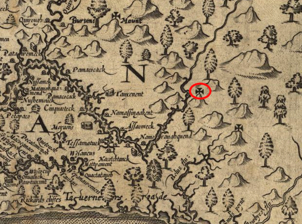
John Smith's 1608 map of NOVA
For more understanding of the first Northern Virginia residents and how they defined their space, read:
- How the Fall Line Shaped Powhatan's Empire
- Arlington Historical Society: Native Americans of the area
- Virginia Historical Society: Becoming a Homeplace
- Northern Virginia Regional Commission: Native Americans in Northern Virginia
- Smithsonian Institution's National Museum of the American Indian: We Have a Story to Tell: Native Peoples of the Chesapeake Region (pages 6-14)