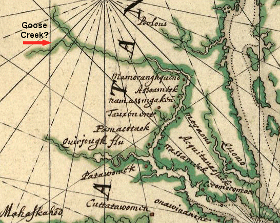
Northern Virginia in 1639
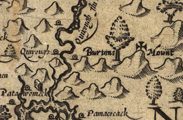
"Patowomack" is modern-day Potomac Creek, while "Quirjough flu" is modern-day Aquia Creek
(Think the unnamed tributary is Goose Creek in Loudoun County - or the Shenandoah River?)
Northern Virginia in 1639
"Patowomack" is modern-day Potomac Creek, while "Quirjough flu" is modern-day Aquia Creek
(Think the unnamed tributary is Goose Creek in Loudoun County - or the Shenandoah River?)
1) Building on last week's map exercise, look again at John Smith's map showing his extent of explorations in Northern Virginia in 1608. (Remember the Maltese cross marked the boundaries of what he actually saw.) He was looking for mineral wealth, especially gold and silver, so he became excited at the prospect of a mine near modern-day Aquia Creek in Stafford County:1
2) Moving ahead in time almost 150 years, look at the Fry-Jefferson map of 1754, and zoom around our region. Great Falls was already named by then, but if you have trouble spelling "Potomac" today... then you might be consistent with earlier mapmakers. Can you see any reason in the physical geography why areas now densly developed, such as Centreville and Manassas, were unsettled 250 years ago?
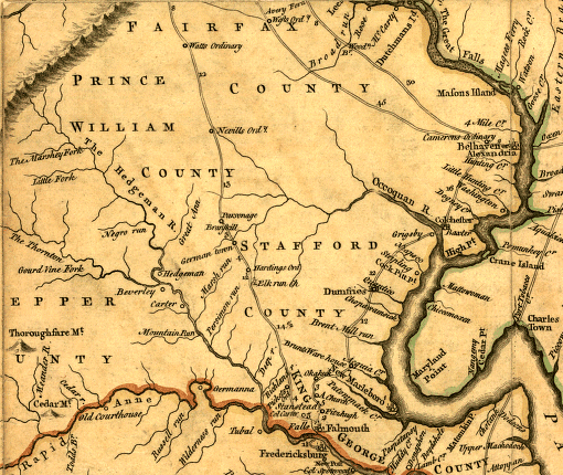
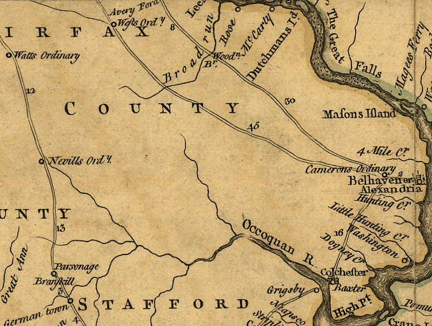
Fry-Jefferson map of Northern Virginia, showing future location of Centreville/Manassas (yes, just blank spots on the map back then...)
Neville's Ordinary was a tavern north of modern-day Warrenton.
Watt's Ordinary was a tavern at the current site of Delaplane, on Route 17 just north of I-66.
- read about the Fry-Jefferson map (note that Peter Jefferson helped survey the Fairfax grant)
- read more about the map (think young Thomas Jefferson made a fair comment on the quality of John Smith's map?)
2) What Happened to the People Who Settled Northern Virginia First?
- Huntley Meadows Park: A Little History by Shirley Scalley
- The Hartwell Site
- November, 2007 issue of The Datum Point
- The Thomas Brown Site, Fairfax County, VA: Archaeologists Get Scoop on Tenant Farmer's Life (it's hard to block modern development of any parcel in a region where land is so valuable, unless the site has a big brick colonial mansion or a house where George Washington may have slept)
3) Conflict during early European settlement of Northern Virginia was religious as well as racial. William Fitzhugh, who acquired the 21,996 acre Ravensworth grant in 1685, tried to attract French Huguenots (Protestant refugees who fled France after that country's king ended official toleration of non-Catholics). Despite the desire of the Virginia colonial officials to import as many people as possible to increase the labor pool for growing tobacco, one particular group of potential immigrants were not welcome - Catholics. (George Washington made a "why can't we all get along" point in 1795 during a fund-raising effort to build the first Catholic church in Virginia. He reportedly made the first contribution.) Look at:
- Ravensworth Grant boundaries (Ravensworth Road was a "rolling road," built to roll large barrels packed with up to 1,000 pounds of tobacco to the port at Colchester on the Occoquan River, just downstream from the Route 1 bridge)
- Parson Waugh's Tumult
- The Brent Family
- Oldest Catholic Church In Fairfax, A National Landmark, Was Built By Irish Railroad Workers
4) Early English settlement in Northern Virginia was complicated by confusion over who owned the land (ignoring the Native American claims completely). The first European settlers were probably indentured servants, tenant farmers, and slaves who occupied land grants to "perfect" the claim and gurantee ownership transferred to the rich Virginia families that had purchased the land. However, it was not clear who had the authority to sell the land. During the English Civil War in the 1640-50's, the king gave all of Virginia between the Rappahannock and Potomac rivers to some allies in that war. The colonial government based in Williamsburg (after the capital moved from Jamestown in 1699) tried to keep selling the land anyway, but lost the right to sell land and issue land grants ("patents") after Lord Fairfax established legal ownership of his proprietary grant in the 1730's.Read:
- The Fairfax Grant
- History of the Fairfax Line
- Northern Neck Land Proprietary Records
5) Under the business model of the 1600's and early 1700's, Virginia tobacco growers shipped their crop to England, and then waited for overseas sale to be completed before receiving credit for their crop. In many cases, small farmers producing only 1-3 barrels ("hogsheads") of tobacco a year would align themselves with large planters generating tens or hundreds of hogsheads a year, and ship it together to England.
A tobacco crop harvested in September might not be shipped and sold for an entire year, leaving the Virginians in debt to English merchants. After England and Scotland agreed to a common king in 1707, English restrictions on "foreign" Scottish entrepreneurs were eased in colonial America. The Scots in Northern Virginia altered the traditional business model for selling tobacco raised in Virginia. They built warehouses and stores in places such as Dumfries and Alexandria (both founded in 1749), and intercepted the tobacco being shipped overseas by small planters in particular. By giving credit or even cash immediately to the Virginia farmers, the merchants created small tobacco trading towns that grew (in the case of Alexandria) into urban centers.
- Dumfries history
- The History of the Prince William County Waterfront
- read Tobacco to Tourism: Celebrating Alexandria's Scottish Heritage
- Carlyle House and a brief biography of John Carlyle, a "factor"
- find the Carlyle House using the city's parcel viewer (address is 121 N. Fairfax Street)
- now you know why there is an annual Scottish Christmas Walk in Alexandria
6) How the Potomac River Shaped the Settlement of Northern Virginia
7) did you know the population of Northern Virginia counties dropped significantly at one time?
- population growth in Northern Virginia
9) see how Northern Virginia has changed into what we see today:
- Fairfax Time Machine (look at Tyson's, Kamp Washington, and Chantilly)
- Development in Kings Park
and
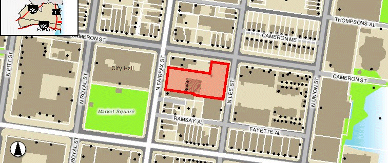
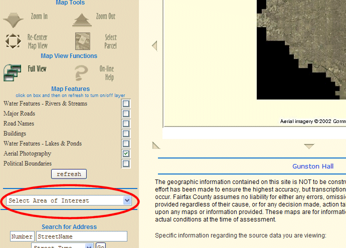
- use the online Geographic Information System (GIS) application to explore the neighborhood today around the GMU Fairfax Campus at My Neighborhood
- use the Aerial/Ortho Photo Viewer to look at Gunston Hall, George Mason's brick colonial mansion, and whatever else interests you in Fairfax County
- read how Ed Risse tries to answer the question Where is Northern Virginia?
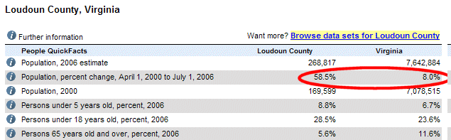
10) Use Census QuickFacts statistics to confirm or revise your assumptions about different jurisdictions, increasing your capacity to discuss the geography of Northern Virginia based on facts rather than just impressions (and perhaps impress not only your friends and neighbors, but maybe even a local city/county official about to make a decision that affects you. Matching our perceptions against the numbers helps us avoid the problem cited in Ed Risse's article, "If you don't know what you are talking about, you don't know what you are talking about."):
- is Fairfax County, Fairfax City, or Falls Church City growing faster than the rest of the state in population? (look at "Population, percent change, April 1, 2000...")
- think the cost of providing schools in Prince William County is a greater percentage of the budget than in the City of Fairfax? (compare "Persons under 18 years old, percent, 2006") Then look at the percentage of residents in those two jurisdictions who are over 65 years old, and may be less inclined to vote for school-related taxes (compare "Persons 65 years old and over, percent, 2006 ")
- think the classic image of a single-family residence in the suburbs is actually true for Stafford, while Alexandria residents are jammed in next to each other in townhomes, condos, and apartments (compare "Housing units in multi-unit structures, percent, 2000")
- Prince William is in a budget crisis, with a substantial increase coming in the local property tax rate. Think the average Virginia resident believes Northern Virginia jurisdictions are relatively rich and should find a way to pay for local services with local taxes, without asking for other regions in the state to supply additional state funding? (compare city/county vs. statewide "Median household income, 2004" and "Persons below poverty, percent, 2004")
11) Current and Projected Demographics:
- look at the detailed Prince William County 4th Quarter 2007 Demographic Fact Sheet Based on the average annual increase in population since 2000, over 1,000 people/month have moved to Prince William County for the last 84 months. Ever wonder why that jurisdiction is stressed about population growth and taxes required to build new roads/schools compared to, say... Fairfax County?
- how we predict the future: Metropolitan Washington Council of Government's Growth Trends to 2030: Cooperative Forecasting in the Washington Region "Smart growth" advocates seek to steer population growth to the locations with existing infrastructure (schools, roads), and to locate new residences near employment centers to minimize commuter traffic. Building new houses on the periphery of the region in Stafford/Prince William/Loudoun, but concentrating jobs at the center in DC/Arlington/Tyson's Corner, will exacerbate the transportation nightmare. Look closely at "Regional Share of Household Growth 2005 - 2030" and then the graphics on page 6 - is the projected growth of the region consistent with the smart growth approach?
12) Finally, glance at The Big Here Quiz. By the end of this semester, you should get a great score for Northern Virginia (but you'll have to look at the sky to see the phases of the moon, and check your watch for times of sunrise/sunset).
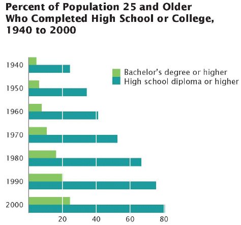
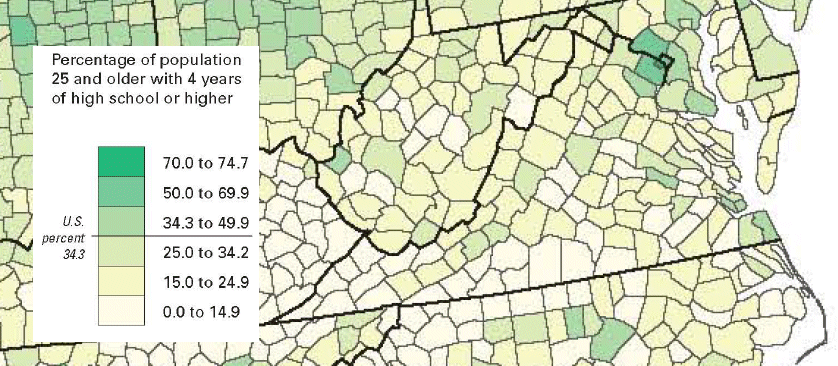
Note how Arlington/Alexandria/Fairfax were "different" even in 1950...
Source: p.162, Census Atlas of the United States
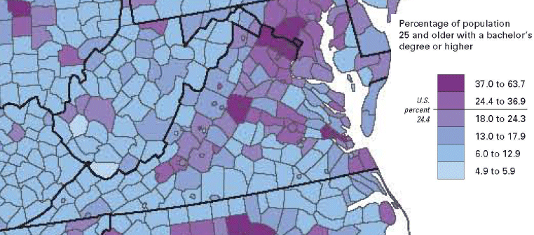
...and offer a more-educated workforce today, making the region attractive to employers
Source: p.163, Census Atlas of the United States