modern wheat field
Northern Virginia's population pattern is easier to document after the Federal government completed a census every ten years, starting in 1790. Prior to the census, population statistics consist of tax records for counties and parishes (Anglican jurisdictions, through which most social services were provided to residents). "Tithables" (free white males over 16 years old, and both male and female slaves over 16 years old) were required to pay a poll tax. Everyone was assessed the same tax; there was no graduated income tax at that time. What little data we have for the colonial population statistics is derived primarily from poll tax records.
In 1742, when Fairfax County was created, the population was around 4,125 people. By 1749, it grew to around 6,2601 as settlement began to occupy land inland from the Potomac and Occoquan rivers. This surge of population has not continued without interruption, however. Fairfax County has over 1 million residents now, and is the most-populated jurisdiction in Virginia - but that concentration of population is a recent phenomenon. For most of its history, Fairfax County has not been the most-populated jurisdiction in even Northern Virginia.
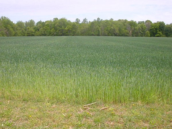
After European settlement, the economy of Northern Virginia was based on tobacco farming. Clearing the forest and exposing the soil creating such massive erosion that the port of Dumfries was blocked by silt, foreclosing the economic growth of the community.
By the time of the American Revolution, nutrients in the Northern Virginia soils were exhausted by constant replanting of the same crop. Many farmers, including George Washington, switched from tobacco to wheat. Farmers built mills along many streams for grinding their own grain into flour, and entrepreneurs like the Tayloe family built "merchant" mills in places like Occoquan so farmers could just bring their wheat for sale.
You can see a preserved and still-operating mill at Aldie in Loudoun County. In Fairfax, the public is welcomed at Colvin Run Mill and George Washington's mill. Ruins of the Chapman/Beverly Mill stand along I-66 at the western edge of Prince William County, and that site is opened to the public occasionally. (How many place/street names do you know in this area that include the word "mill"?)
However, the first decades of the 1800's were a period of economic decline in Northern Virginia. Lands elsewhere were more fertile. As new lands were opened to settlement in Kentucky, Ohio, Indiana, and Illinois, the line separating settlement from backcountry (the frontier) moved west. Slave-based agriculture boomed in the southern states such as Alabama, Mississippi, and Louisiana. Farmers migrated away from Northern Virginia, and many slave-owners sold their "property" to work down south.
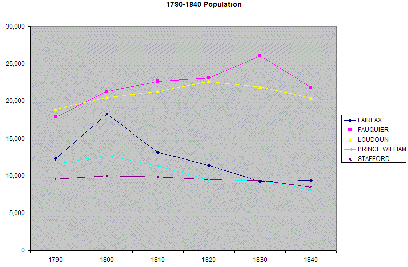
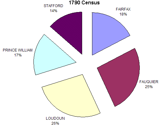
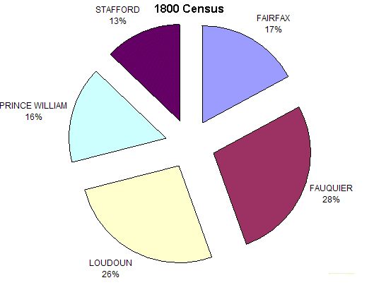
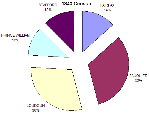
Population north of the Rappahannock River and east of the Blue Ridge grew only 21% in the 70 years between 1790 and 1860:
The location of the national capital on the Potomac River did not stimulate economic growth in the former Virginia portion of the District of Columbia. When residents in Alexandria, DC requested funds for canal and turnpike construction, the Federal government declined - and so did Virginia, since the District of Columbia was not part of Virginia. In 1847, the Federal government "retroceded" that territory back to Virginia, in part because it assumed the District's growth would never reach the point where that land would be needed. (Another possible reason: the US Congress was getting prepared to end slavery in the District of Columbia. Putting the Potomac River between a "free" district and a slave state may have been part of the thinking.)
When World War I stimulated expansion of Federal employment in DC, suburbs finally developed in Arlington/Alexandria. The Northern Virginia suburbs grew dramatically in stages as the Federal government expanded during the Depression, World War II, and the Cold War. Demographers now project continued massive growth to the year 2030, and "the suburbs" have now expanded to include Loudoun, Prince William, Stafford, and other jurisdictions on the periphery of the inner suburbs/core jurisdictions.
You can see the pattern in the statistics from the various censuses:
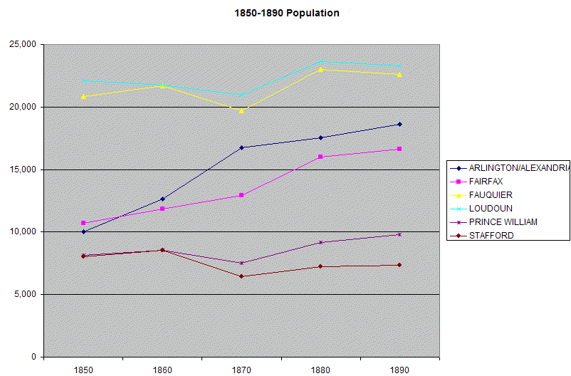
1850-1890 census statistics (note that Alexandria/Arlington are included)
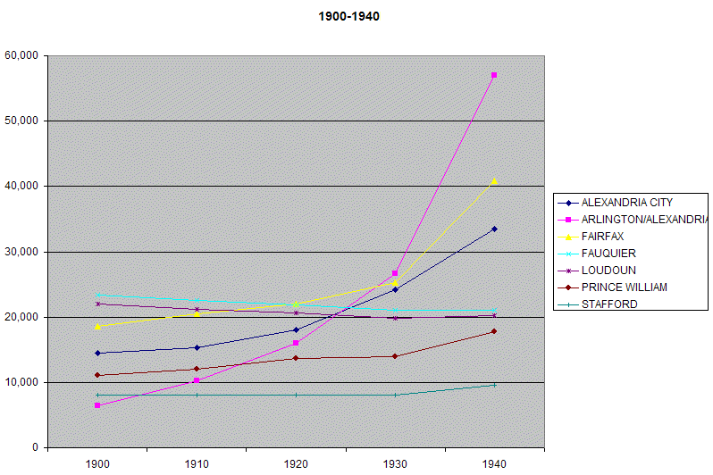
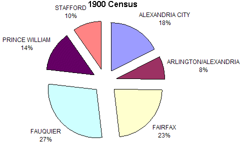
1900-1940 census statistics (note that Alexandria/Arlington are booming
even before the US enters World War II)
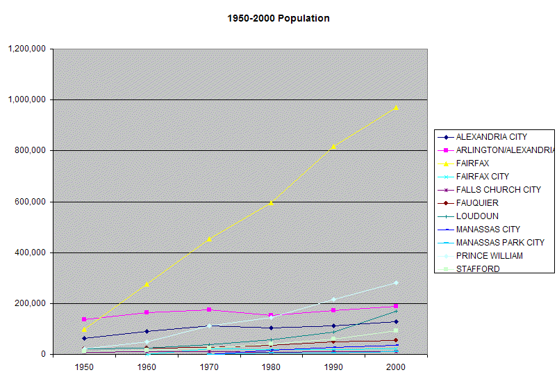
1950-2000 census statistics (note that independent cities were carved out of Fairfax and Prince William counties)
Note how the agricultural population in Fauquier was larger than in Fairfax, before suburban growth occurred:
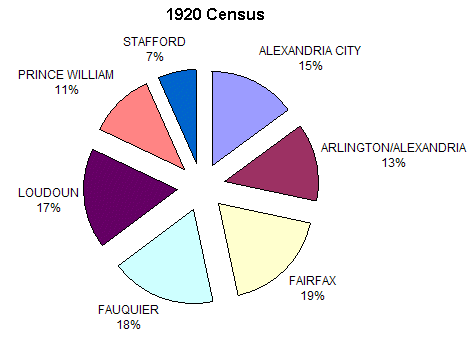
Finally, Fairfax County population exceeds Fauquier County population...