
geographic distribution of the first six state parks established in 1936
Map Source: Color Landform Atlas of the United States
geographic distribution of the first six state parks established in 1936
Map Source: Color Landform Atlas of the United States
Virginia started its state park system with a bang, opening six parks simultaneously in 1936. The governor conducted an opening ceremony at Hungry Mother State Park on June 13, and the first six parks opened to the public on June 15, 1936:
Seashore State Park (now called First Landing)
Westmoreland State Park
Staunton River State Park
Douthat State Park
Fairy Stone State Park
Hungry Mother State Park
Creating the state park system had started a decade earlier. The State Commission on Conservation and Development, created in 1926, had initially focused on acquiring lands to be donated to the Federal government for the creation of Shenandoah National Park. Residents in southwest Virginia advocated for creating what is today's Breaks Interstate Park, while others sought a seashore park on the Atlantic Ocean shorline.
In 1933, William E. Carson was chair of the State Commission on Conservation and Development. He met with President Frankin D. Roosevelt at former president Herbert Hoover's retreat in Rappahannock County, then called Camp Rapidan, and suggested the Civilian Conservation Corps (CCC) should be tasked to develop state parks as well as work on Federal lands. In anticipation of getting CCC labor, the state acquired the land needed to open the six parks.
Land for what became Sailor's Creek Battlefield State Park was acquired in 1937. The Federal government transferred recreation demonstration areas at Bear Creek, Holliday Lake, Goodwin Lake and Prince Edward to the state in World War II, and in 1943 the state was gifted the Southwest Virginia Museum. The Swift Creek Recreation Demonstration Area was transferred from Federal to state ownership in 1946 and renamed Pocahontas State Park. Claytor Lake State Park became part of the system in 1951; local residents had purchased half the land as a donation to the state.
In 1948, a reorganization of state agencies converted the Virginia Conservation Commission into the Department of Conservation and Development. That was divided in 1985, and today Virginia State Parks is a unit in the Department of Conservation and Recreation (DCR).1
Virginia parks were for whites-only when started in 1936, but segregation law required the state to provide equal if separate facilities. In 1939, the Goodwin Lake Recreational Area was opened in Prince Edward County as a "Colored Only" recreation area while nearby Prince Edward Lake was opened as a "whites only" recreation area.
After World War II, legal challenges to segregation included a lawsuit that forced the state park system to upgrade the services it offered to people of color. After Maceo Martin was blocked by Jim Crow laws from entering Staunton River State Park in 1948, he filed suit. The Virginia Conservation Commission responded by enhancing the facilities at Goodwin Lake Recreational Area to make them equal while keeping them separate.
The state added cabins, concession stand and a bathhouse. The swimming area and parking were expanded, and the site was renamed "Prince Edward State Park for Negroes."2
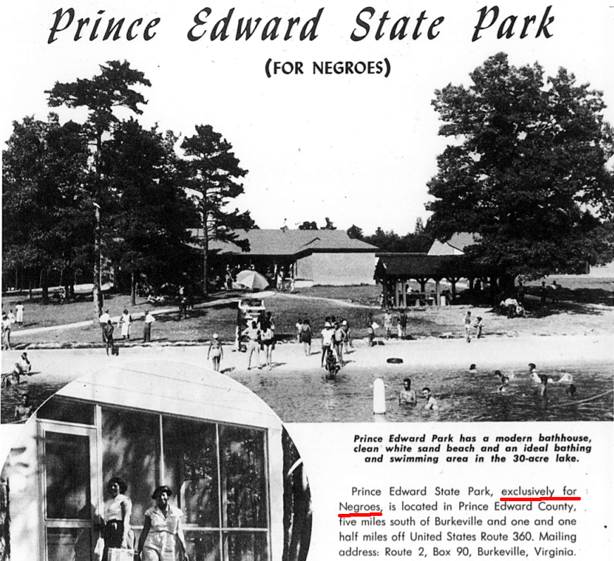
Prince Edward State Park was developed exclusively for Negroes
Source: Virginia Department of Conservation and Recreation, Prince William State Park
To provide recreational opportunities for non-whites blocked from using Douthat State Park after getting pressure from the National Association for the Advancement of Colored People (NAACP), the Dolly Ann Civilian Conservation Corps Camp F24 of the Civilian Conservation Corps developed the Green Pastures Recreation Area in Alleghany County. It was 11 miles away within the George Washington National Forest near Covington. When opened in 1940, Green Pastures provided a lake for swimming, together with a sandy beach, bathhouse, hiking trails, and other facilities.
The Federal government declared that Green Pastures Recreation Area was open for use by whites and non-whites in 1950, and renamed the site Longdale in 1964 to obscure the previous racial restriction. The US Forest Service closed Longdale Recreation Area in 2017 due to budget constraints. The Virginia State Park system obtained a 30-year lease and reopened it in 2021. Governor Northam included $5 million for dam repair and restoration of the Civilian Conservation Corps buildings in his final 2022-2024 budget.3
The Brown v. Board of Education decision by the US Supreme Court in 1954 made clear that the state parks, like the school system, would have to desegregate. To prevent integration, the Virginia Conservation Commission considered closing or selling the state parks. The agency decided instead to lease Seashore State Park to a private operator, anticipating that Federal courts would allow a non-government operation to continue to discriminate by race. The park was closed in 1955 until a court decision would authorize a lessee to do what a government agency could not do.
The state gradually reopened Seashore State Park to public access without requiring segregation; the campground began operations again in 1963. The beach and cabins were not reopened until 1965, after the US Congress passed the 1964 Civil Rights Act.
During the desegregation period when Virginia considered divesting the state park system, no land was acquired to open any new parks. Conservation efforts focused on creating the Natural Areas System, started in 1960.
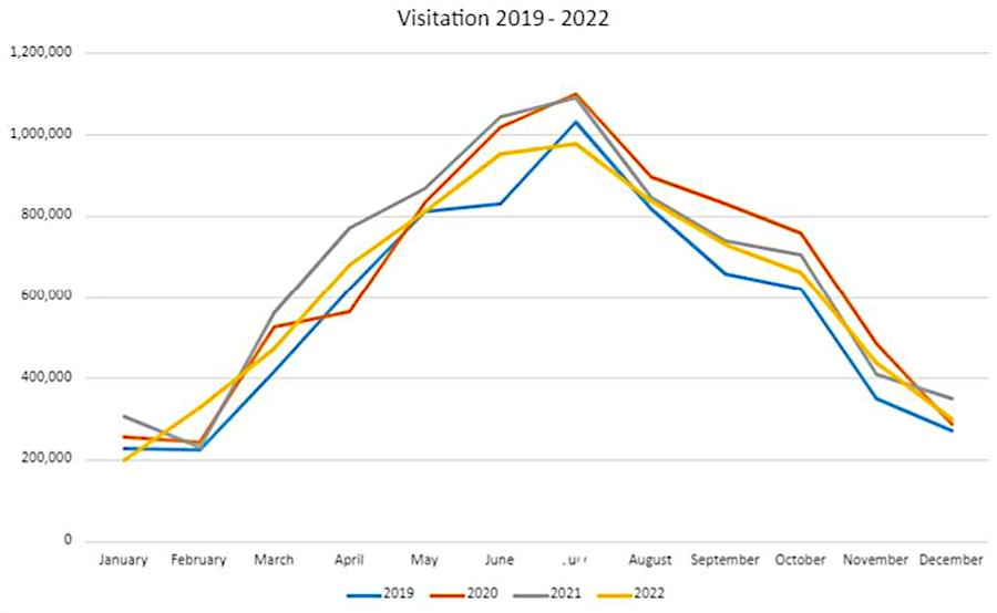
visitation to state parks follows a seasonal pattern
Source: Board of Conservation and Recreation, Minutes, May 4, 2023
The post-World War II baby boom created a strong demand for new parks, and the federal government provided funding through the Land and Water Conservation Fund (LWCF) program. Guided by the state's first Statewide Comprehensive Outdoor Recreation Plan, "Virginia’s Common Wealth," 12 new state parks were established between 1965-1975.
The state focused on developing facilities in the new parks; only one new park was added in the next 15 years. In 1987, Virginia accepted a donation from Norfolk Southern of the abandoned rail line along the New River and created New River Trail State Park.
A 1992 bond issue funded additional facilities in existing state parks and acquisition of land for six new parks. A 2002 bond issue expanded funding for facilities and creation of another five parks. As of 2026, the 90th anniversary of the Virginia State Parks system, there were 44 units with more than 80,000 acres. The most recent park to open was Culpeper Battlefields in 2024.4
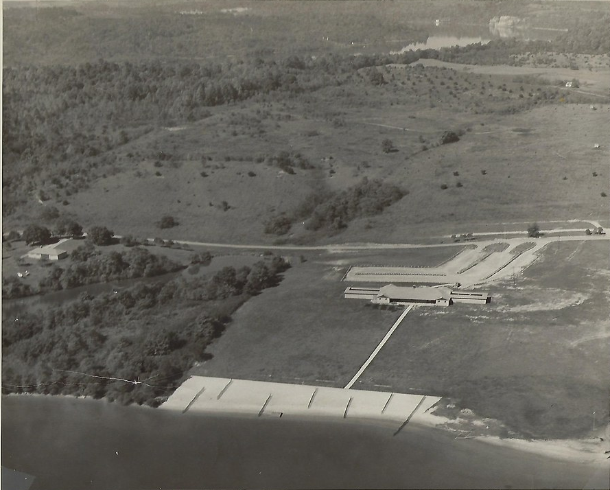
Claytor Lake State Park in early 1950's
Source: Virginia State Parks, Claytor Lake State Park Virtual History Tour
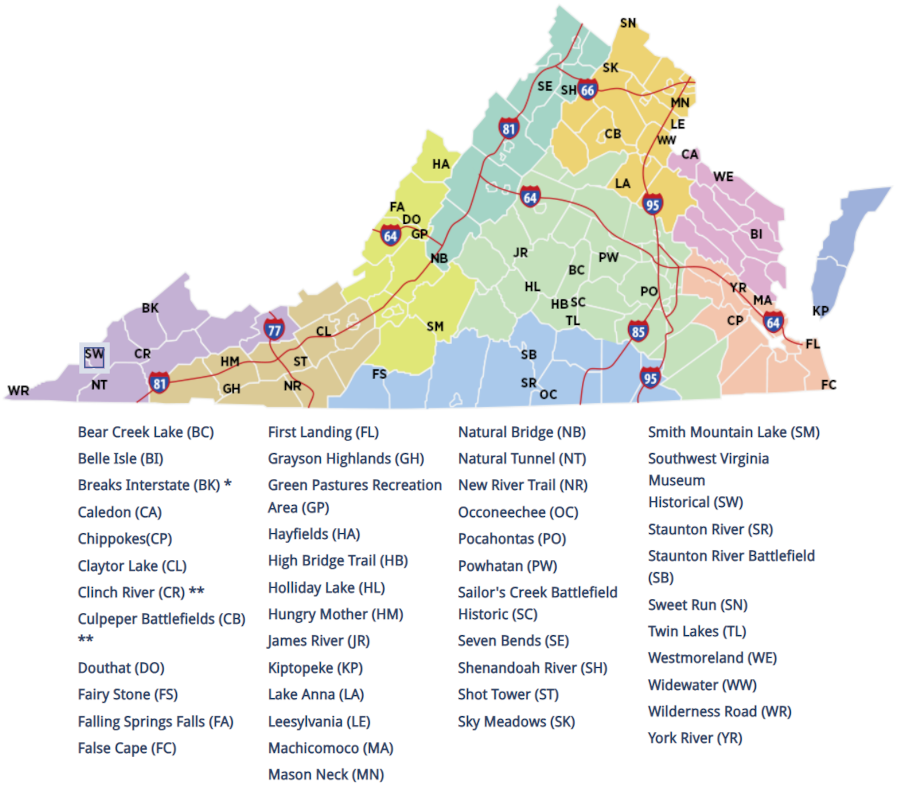
in 2026, there were 44 units in the Virginia State Park System
Source: Virginia State Parks, Find a Park