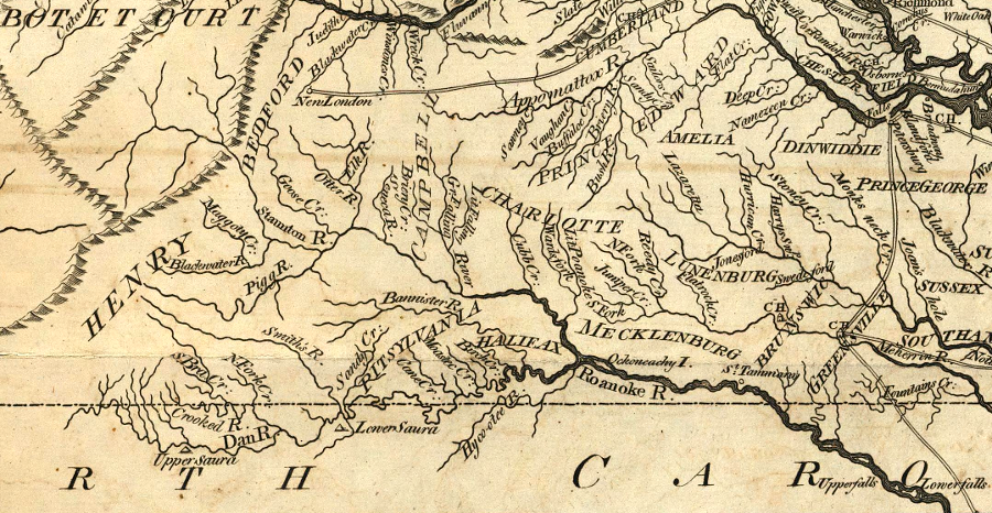
Southside Virginia includes the Roanoke River watershed, south of the James River
Source: David Rumsey Historical Map Collection, The State of Virginia from the best Authorities (by Samuel Lewis, 1794)
Southside Virginia includes the Roanoke River watershed, south of the James River
Source: David Rumsey Historical Map Collection, The State of Virginia from the best Authorities (by Samuel Lewis, 1794)
Southside could be defined very roughly as the region south of the James River, east of the Blue Ridge, west of Tidewater, and north of North Carolina. Much of it is in the Roanoke River watershed. Early English colonists moved up the valleys of rivers that flowed into the Chesapeake Bay, and the Roanoke River watershed was slower to develop.
Formation of counties was slow because population growth was slow. "Southside" was the frontier at Southampton and Brunswick counties.
In the early 1700's the colonial governors were accused of favoring development of the region north of the James River. Governor Spotswood built Fort Christianna, but that lasted only briefly. He focused his speculatins and investments on land in the Rapidan/Rappahannock watershed, where he started his Germanna colony.
The James River and North Carolina boundaries of the region are less controversial than the northern and southern edges of Southside. However, the residents of Chesterfield and Powhatan counties, plus those in Petersburg, Colonial Heights, and Dinwiddie, might prefer to be classified as part of the Richmond-centered "capital region" or Central Virginia now.
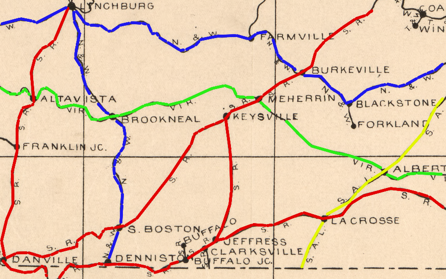
by 1900, Southside was connected to port cities by multiple railroads
Source: Library of Congress, Railway mail map of Virginia (by Earl P. Hopkins, 1910)
Even before the construction of the James River and Kanawha Canal, Lynchburg was economically linked to Richmond. With the construction of the South Side Railroad and the Richmond and Danville Railroads before the Civil War, the Appomattox River watershed was linked closely to Petersburg and the Chesapeake Bay economy.
The nortern edge of Southside could be defined by the Roanoke and James river watersheds, excluding Petersburg and Lynchburg. Everything south of the divides separating the Nottoway/Appomattox and Roanoke/James rivers could be defined as "Southside" now.
One way to define the Southside region is to use the boundaries of the Virginia Beach-Norfolk-Newport News VA-NC, Richmond VA, Lynchburg, and Danville Metro Areas. Whatever is not within those metropolitan areas would be "Southside," by defintion a rural region.
Southampton County would be in Southside, separated from Sussex, Surry, and Isle of Wight counties. An argument could be made that Campbell County should be excluded from Southside and lumped in with the City of Lynchburg. However, a definition of "Southside" with a western edge that does not include Halifax and Pittsylvania counties does not reflect modern (though still vague) cultural undertandings of the region.
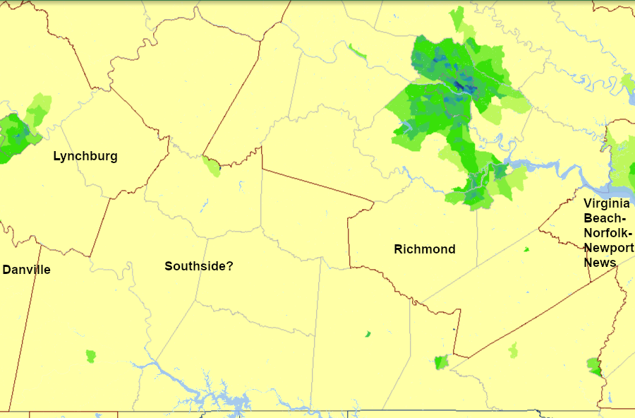
modern Southside Virginia could be whatever is not included in a Metro Area
Source: Bureau of Census, Metropolitan and Micropolitan Population Density by Census Tract: 2010
The watershed divide separating the Chesapeake Bay drainage from the Chowan/Albemarle Sound watershed could be used to define the eastern edge of Southside.
However, this would separate the northern and the southern halves of the modern-day cities of Suffolk, Chesapeake, and Virginia Beach. Few people would consider Back Bay, adjacent to the Atlantic Ocean, to be a section of Southside - it's clearly part of the region known as Tidewater or Hampton Roads, and rebranded as Coastal Virginia.
An historical basis could justify an eastern boundary at the Blackwater River. During the Civil War, the river was the dividing line between the Union-occupied territory and Confederate Virginia. Confederate picket lines were porous enough for thousands of "contrabands" - as the Northern generals categorized the enslaved blacks - to flee east out of Southampton County. Freedom required getting across the Blackwater River and into Nansemond or Isle of Wight counties.
People fleeing slavery had to avoid traveling further east if they wanted to stay legally free. At the start of 1863, the Emancipation Proclamation freed the slaves in only part of Virginia, excluding:2
Enslaved people who crossed the river into the Union camps in Isle of Wight or Nansemond County (now part of the City of Suffolk) were freed by Lincoln's proclamation. However, if they kept travelling east and crossed the Dismal Swamp and entered Norfolk County (now part of the City of Chesapeake) or the cities of Portsmouth and Norfolk, they entered a region occupied by the Union in 1862. Lincoln tried to avoid disturbing local arrangements in Tidewater by exempting slaves in that region.
If the South had managed to stalemate the war and negotiate a settlement rather than surrender, the origin of contrabands in the region could have become an issue. A precedent was set 85 years earlier at Yorktown, when Cornwallis abandoned most of the enslaved people he had taken within his lines. If the Confederates had been as successful as the "rebels" in the American Revolution, the Union might have negotiated the return of contrabands who were living within the area excluded from the Emancipation Proclamation.
The cultural feature of Interstate 95 could be used as the eastern edge, but that would exclude Southampton and Sussex counties. Creeping suburbanization from Suffolk has not reached far enough west to justify including them within Hampton Roads, so by default they may be part of Southside.
"Southside" could be defined by the range of tobacco growing. Three comercial sales "belts" for Virginia or bright tobacco were defined by the tobacco industry - the Old Belt, Eastern Belt, and Border Belt. West of Southside, across the Blue Ridge into Kentucky and Tennessee, farmers grww burley tobacco. That is a darker leaf, air-dried rather than flue-cured like Virginia tobacco.
If tobacco belts were used, then the western edge of Southside would butt up against the Blue Ridge. On the northern edge, Franklin County could be considered part of Southside. though it was known more for moonshining in the mountains rather than for its tobacco. Lynchburg was a major tobacco processing center, so it would be included.
Patrick County could be included or excluded. If watershed boundaries are part of the definition, it may be relevant that the couny seat, Stuart, is in the Pee Dee River watershed. Stormwater runoff and wastewater from the town flows not int the Roanoke River, but through the Carolinas into the Pee Dee River before reaching the Atlantic Ocean far south of the Albemarle Sound.
Economically, the communities west of Halifax County culd be labelled as part of "Southern Piedmont" industrial region rather than part of the more-agricultural, forested Southside. Dr. Jim Fonseca used the boundaries of planning districts to define nine regions of Virginia.3
He based his Southside consisted of three planning districts - Southside (13), Piedmont (14) and Crater (19) - while the Southern Piedmont-Valley Industrial Zone included four districts - New River Valley (4), Fifth (5), Central Virginia (11), and West Piedmont (12).
By that definition, Petersburg was lumped together with South Boston and Halifax, which were split from the Danville Metropolitan Statistical Area. Obviously, the names of the planning districts do not match the names assigned to the regions in the article. It is as much art as science to define the regions of Virginia.
Planning district commissions are voluntary associations, and oundaries change. Surry County has been included in both the Crater and the Hampton Roads districts.
Economic boundaries have meaning. The impacts from post-NAFTA closure of textile plants are of serious concern in Halifax, Pittsylvania, and Henry counties. Further east, the rural roads are filled with timber trucks carry pulpwood to mills in Roanoke Rapids (North Carolina) and Franklin, plus numerous vehicles trailering boats for use on Buggs Island reservoir, rather than tractor trailers loaded with materials for producing sweatshirts and other "fleece goods" from textile mills.
Source: Senate of Virginia
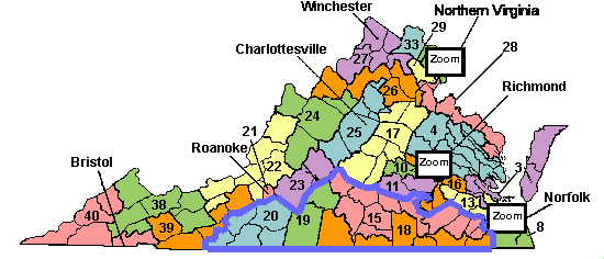
Another way to define "Southside" is by State Senate districts. In particular, the elected representatives from the 15th, 18th, 19th, and 20th districts would traditionally be considered as representatives of Southside Virginia interests. The State Senators from the 23rd and the 11th districts would also be considered close allies, if not card-carrying members of a Southside Caucus.
Population statistics and local government finances can be used to define the edges of Southside.
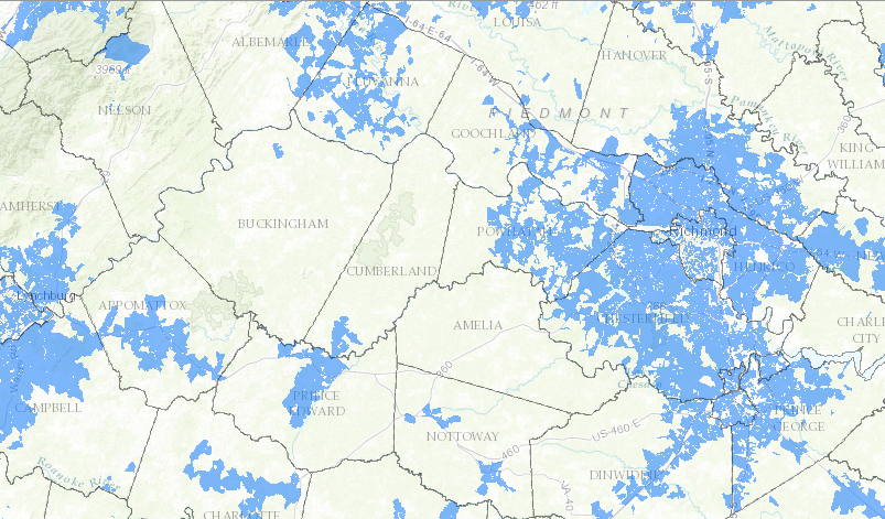
in 2016 the urban centers of Richmond and Lynchburg plus their suburbs had access to televsion and internet services via cable (blue area on map), but Amelia, Cumberland, and Buckingham counties relied upon slower DSL and wireless technology
Source: Virginia Office of Telework Promotion and Broadband Assistance, Coverage Maps
Watershed boundaries shaped population growth in the 1600's and 1700's, and still have significance today.
One characteristic of the modern Roanoke River watershed is the number of large hydropower reservoirs. There may be as many large powerboats in Southside as in Tidewater.
Those reservoirs enhance the water quality downstream, in contrast to most Virginia rivers which have less pollution near their headwaters. As noted in a US Geological Survey report:4
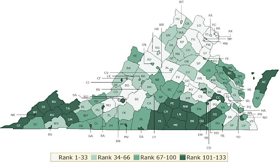
Southwest Virginia and Southside are two regions with particularly poor health
Source: University of Wisconsin Poulation Health Institute, 2019 Virginia Health Outcomes Map