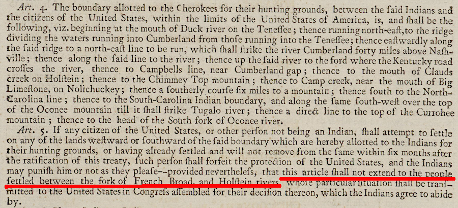
- 1677 Treaty of Middle Plantation (and 1680 addendum)
- - negotiated in 1677 after conclusion of Bacon's Rebellion, in which tribes at peace with Virginia government had been attacked by rebels led by Nathaniel Bacon
- - terms were defined by three royal commissioners (Lieutenant Governor Herbert Jefferies, Sir John Berry, and Francis Morison) who controlled colonial government after they forced Gov. William Berkeley to return to England
- - Cockacoeske ("Queen of Pamunkey") signed for not only Pamunkey, but also for Chickahominy and Rappahannock tribes (English colonists wanted to centralize authority and simplify their control, but other tribes refused to accept subordinate status)
- - signed separately by Cockacoeske's son (Captain John West), the queen of the Wyanoke, king of the Nottoway, and king of the Nansemond
- - English refused to allow king of the Appomatucks to sign in 1677, because they thought he was responsible for unrequited death of colonists
- - additional tribes that signed in 1680 included leaders of the Appomatucks (finally), Iroquoian-speaking Meherrin, Siouan-speaking Monacan and Saponi, plus Nanzatico (Nantaughtacund), Portabaco, and an additional Nansemond king4
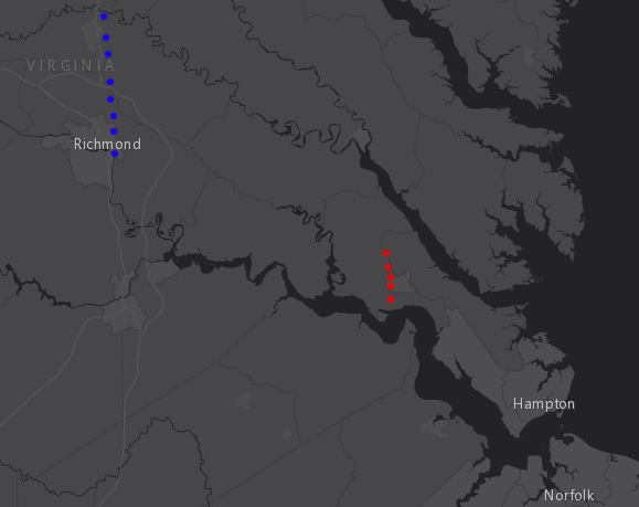
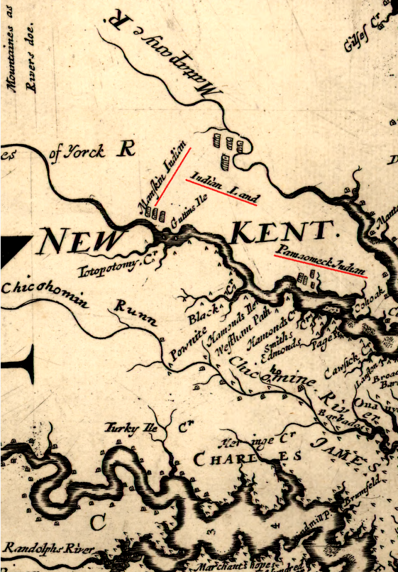
- - established a reservation in King William County (because the now-separate Mattaponi and Pamunkey reservations were established a century before the United States was created, the legal basis for those reservations is based on Virginia state law rather than Federal law.)
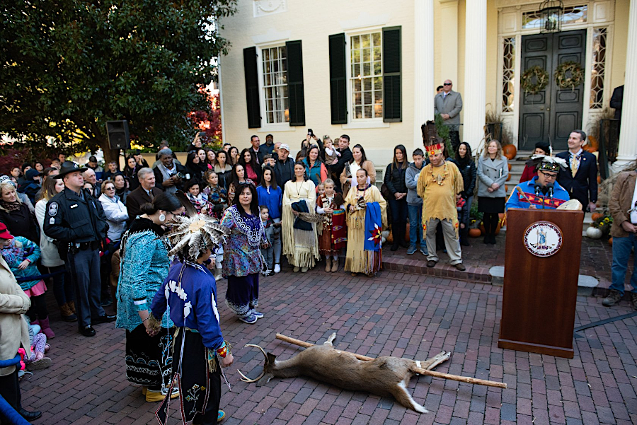
- - confirmed Native Americans would not have to pay quit rents on their reservation land, but required annual symbolic payment of three arrows to the colonial governor in addition to the 20 beaver skins as required in 1646 (a ceremonial gift of deer and/or turkeys is presented to the Virginia governor every year around Thanksgiving, to honor this treaty)
- - banned enslavement of Native Americans who belonged to groups that were friendly with the English
- - required friendly Native Americans "having notice of any March of strange Indians near the English Quarters or Plantations" to alert the English about threats from Susquehanna from Pennsylvania, Iroquois from New York, etc.
- - declared Native Americans would be "Secured and Defended in their Persons, Goods and Properties, against all hurts and injuries of the English" and anyone committing a crime would be punished according to "the Laws of England or this Countrey," suggesting an equal protection of civil rights for both Native Americans and colonists "which is but just and reasonable, they owning themselves to be under the Allegiance of His most Sacred Majesty"
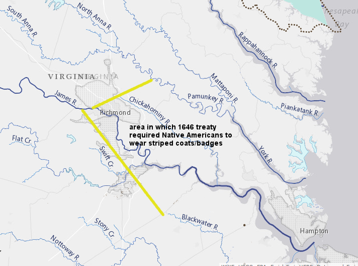
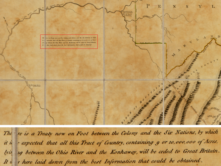
- - created buffer zone of three miles around Native American towns, and made clear colonists could not settle within that zone and would be removed if they tried:5
- "Whereas by the mutaull discontents, Complaints, jealousies, and feares of English and Indians occasioned by the violent intrusions of divers English into their lands, forceing the Indians by way of Revenge, to kill the Cattle & hoggs of the English, whereby offence, and injuries being given, and done on boeth sides, the peace of this his Majesties Colony hath bin much disturbed, and the late unhappy Rebellion by this means in a great measure begunne & fomented which hath involved this Country into soe much Ruine, & misery, for prevention of which injuries and evill consequences as much as possible we may for time to come it is hereby concluded and enacted that noe English, shall seate or plant nearer then three miles of any Indian towne, and whosoever hath made or shall make any encroachment upon their Lands shall be removed from thence...
- authorized Native Americans who were part of treaty to hunt, fish, and gather plants on lands outside reservation, after first receiving a certificate from an English magistrate
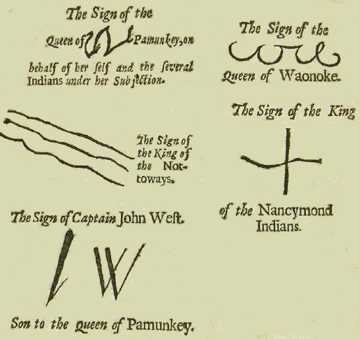
marks of Native American leaders who signed the Treaty of Middle Plantation in 1677
Map Source: College of William and Mary, Articles of peace between the most serene and mighty Prince Charles II. by the grace of God, king of England, Scotland, France and Ireland, defender of the faith, &c. and several Indian kings and queens, &c. : Concluded the 29th day of May, 1677
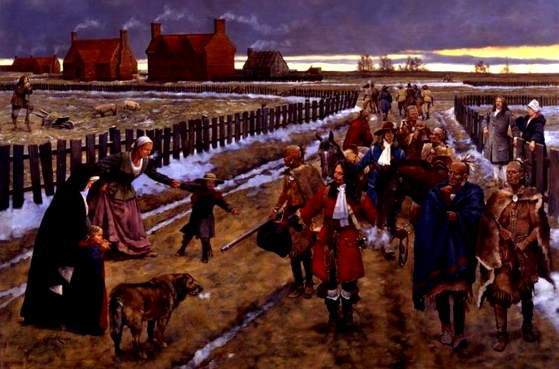
in 1690, the Nottoway tribe brought their annual tribute payment to the governor of Virginia in Jamestown
Map Source: National Park Service, Jamestown in the Winter of 1690 (painting by Keith Rocco)
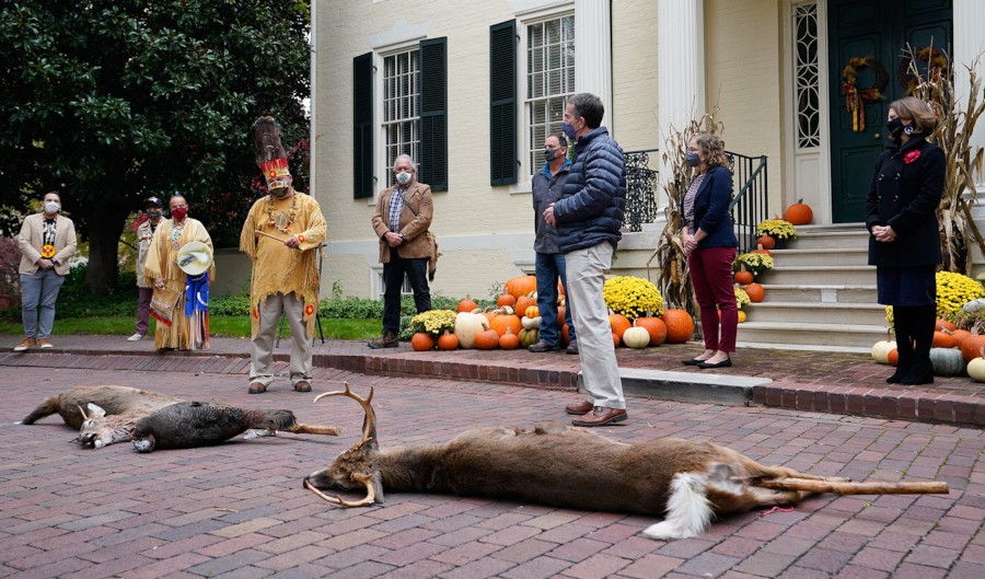
Source: Governor of Virginia, Governor Northam Hosts 343rd Annual Indian Tax Tribute Ceremony, Commemorates Native American Heritage Month in Virginia
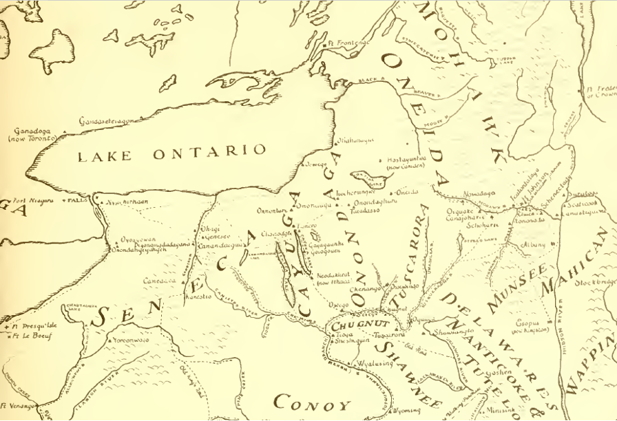
- 1679 Albany Conference
- - established the "Covenant Chain" linking English and Iroquois, after Bacons Rebellion in Virginia and King Philips War in New England
- - made allies of English and Iroquois, who were competing in beaver wars with Huron and other tribes trading furs with French in Montreal
- - permitted Iroquois to hunt and travel trough Manahoac lands, blocked Algonquian tribes in Tidewater from Piedmont
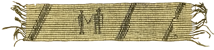
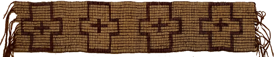
negotiations involving the Iroquois in New York and Pennsylvania including presentation of wampum belts with different color beads creating specific patterns to emphasize key points or "words" spoken by the Native American leaders, and those belts could be brought to future meetings to renew understandings and commitments - while the colonists preferred to document negotiations in written treaties
Source: Frank G. Speck, The Penn wampum belts (opposite p.12, p.16)
- 1684 Albany agreement ("Lord Howard's treaty")
- - after Bacon's Rebellion ended in 1676, Seneca, Onondaga, Cayuga, and Oneida were conducting raids south into Virginia Piedmont, seeking to control local tribes plus Piscataway and Susquehannock disrupted by Maryland/Virginia forces
- - Virginia governor Lord Howard of Effingham (called "Assarigoa" by the Iroquois) traveled from Virginia to Albany to negotiate with the Iroquois in concert with the New York governor, Col. Thomas Dongan (called "Corlear" by the Iroquois, as were all the New York governors)
- - Virginia governor's primary objective was to end warfare in Virginia's western borderlands
- - New York governor's primary objective was to retain control over all colonial negotiations with Iroquois, preventing creation of a new "council fire" in Virginia which might lead to fur trade being diverted away from Albany
- - Iroquois's primary objective was to assert control over Native American groups living in Pennsylvania west of Susquehanna River and in Maryland/Virginia Piedmont (specifically the Cahnawaas - also known as the Conoy, remnants of the Piscataway), to increase power/population of the Five Nations and to facilitate continued raids south to attack the Saponi, Cherokee, and others
- - Seneca, who kept the "western gate" of the Iroquois confederacy, were raiding as far west as Mississippi River and threatening to establish control over fur trade
- - threat of any Virginia attack on Iroquois to stop raids was ended by higher priority of ensuring Seneca were at peace with English and directed trade to Albany, rather than French-controlled Montreal
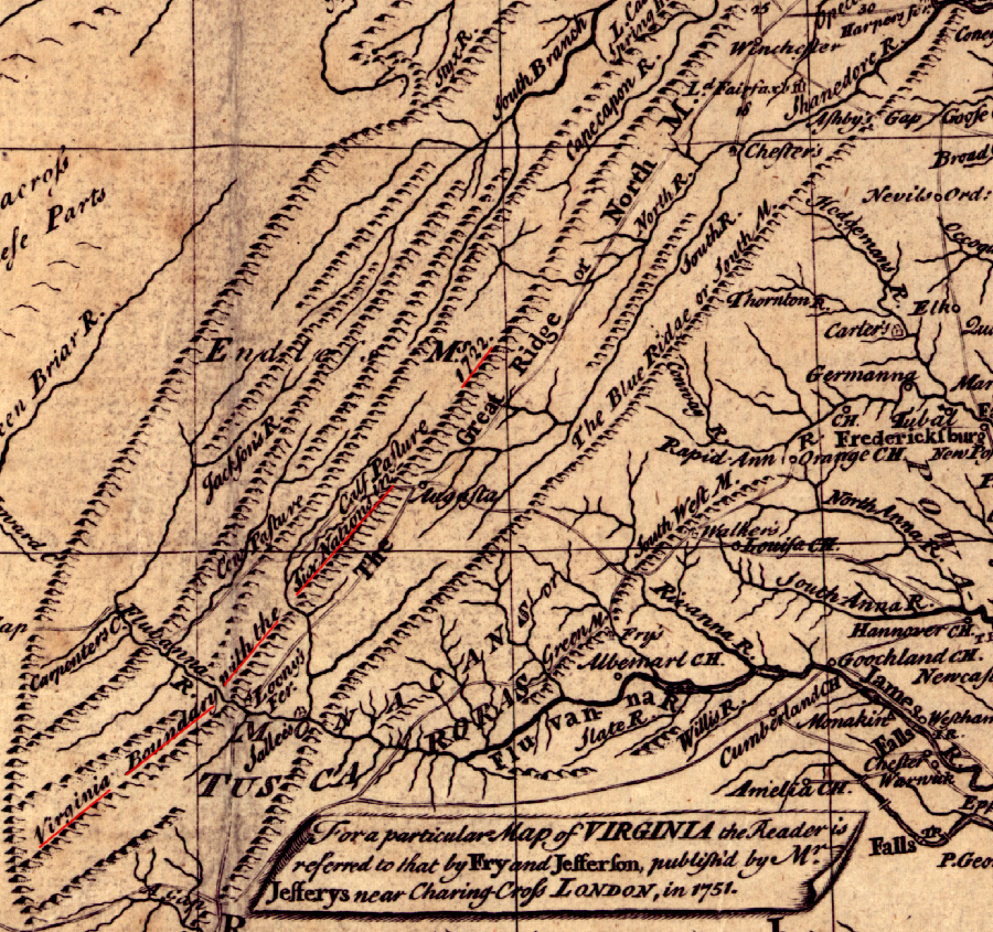
- - Mohawks and Senecas agreed the Iroquois "must not come near the Heads of your Rivers, nor near your Plantations, but keep at the Foot of the Mountains"6
- - from Iroquois perspective, agreement blocked English settlement in Iroquois-controlled Piedmont at base of Blue Ridge, and that territory was used for hunting and travel on Shenandoah Hunting Path/Old Carolina Road until 1722 Treaty of Albany
- - colonists built a blockhouse 15 miles west of the Fall Line (on the western edge of the modern Quantico Marine Corps Base) to protect settlers expected to occupy the Brent Town Grant, in recognition that Iroquois raiding parties would be traveling through the Piedmont7
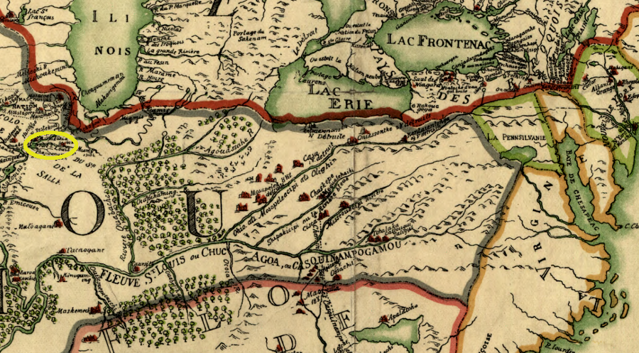
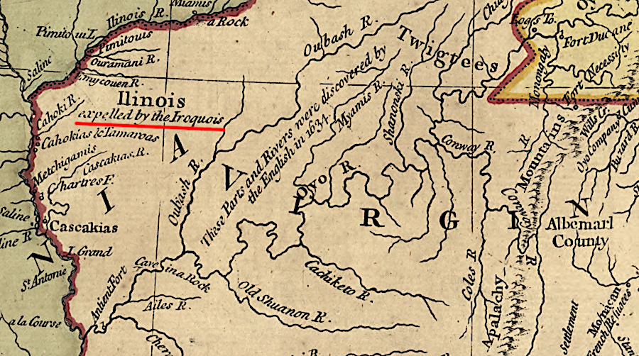
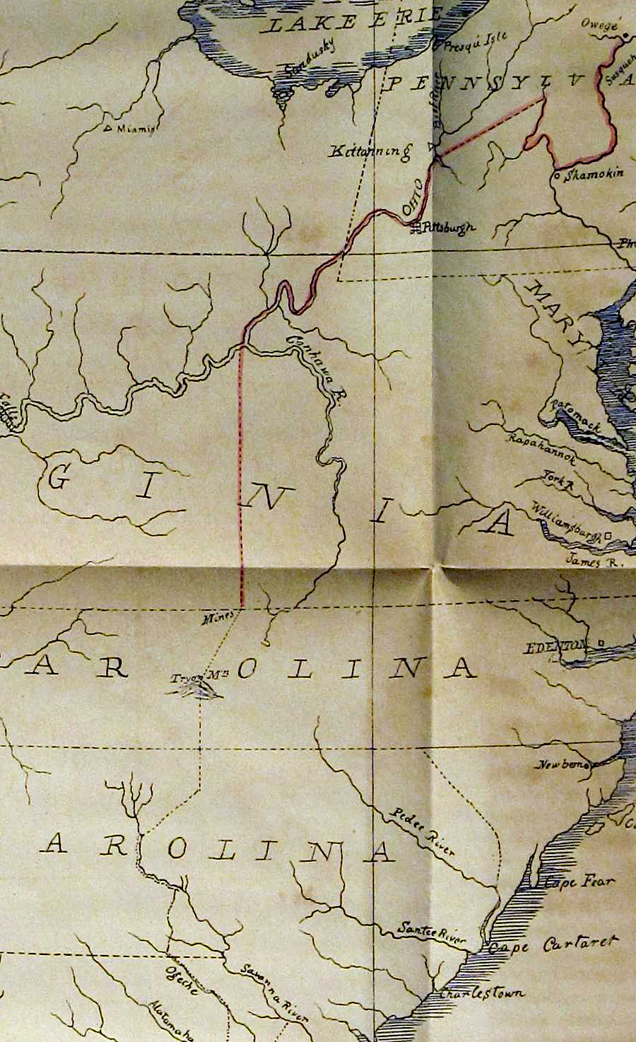
the French repelled Seneca attacks on Fort St. Louis (yellow ellipse) on the Illinois River, but in recognition of Iroquois power Governor Howard minimized his demands in 1684 in exchange for promises to travel/hunt through the western Piedmont, away from the colonial tobacco quarters and farms being settled west of the Fall Line
Source: Library of Congress, Franquelin's map of Louisiana (originally created around 1684)
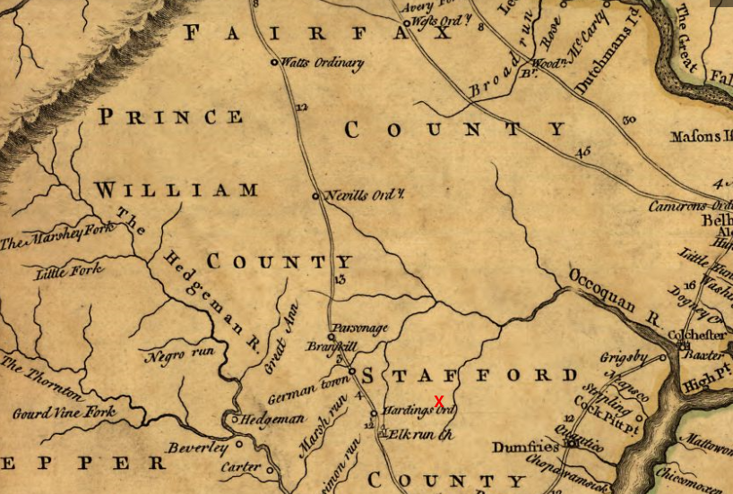
King James II made the Brent Town Grant soon after the Iroquois agreed to "keep at the Foot of the Mountains," and the location of the block house constructed near Dorrell's Run to protect settlers from possible raids (red X) indicates how little of the Piedmont was controlled by the colonists
Source: Library of Congress, A map of the most inhabited part of Virginia containing the whole province of Maryland with part of Pensilvania, New Jersey and North Carolina (by Joshua Fry and Peter Jefferson, 1755)
- 1701 Nanfan Deed
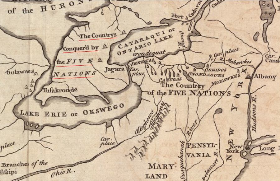
- - during the Beaver Wars in the 1640's, the Iroquois conquered the Huron, Petun, Neutral, and other tribes in Southern Ontario
- - between 1689-1700, Iroquois population was reduced 50% by fighting with French and the western tribes during King William's War; Mississauga and their allies pushed Iroquois out of Ontario by 1700
- - in 1701, the Five Nations (the Tuscarora had not joined yet) granted their claims to the Beaver Hunting Grounds to the English, claiming ownership by Right of Conquest of the land:8
- formerly posest [possessed] by seaven nations of Indians called the Aragaritka whom by a fair warr wee subdued and drove from thence four score years agoe bringing many of them captives to our country and soe became to be the true owners of the same by conquest
- - the Iroquois transferred a block of land "in length about eight hundred miles and in bredth four hundred miles" (including lands west to the Illinois River and extending far south of the conquered territory down to the Ohio River) because they did not control it and sought to get English to conquer it for them, but French were too powerful and established fort at Detroit in 1701
- - in 1726, when colonial settlement was beginning to push the Iroquois westward from their homelands, the deed was modified to authorize Iroquois settlement in a strip of land 60 miles wide along Lake Ontario and Lake Erie
- - Nanfan Deed is cited as basis for Canadian government to allow modern Iroquois to hunt in Southern Ontario's Short Hills Provincial Park9
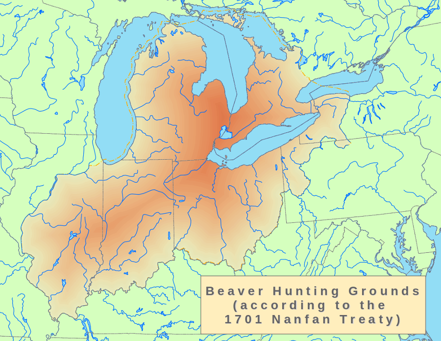
in 1701 the acting colonial governor of New York, John Nanfan, acquired the western lands claimed by the Iroquois after their success in the Beaver Wars)
Source: Wikipedia, Nanfan Treaty
starting in 1755, John Mitchell published maps that were used by the English to assert their claims to lands in North America that were also claimed by the French
Source: David Rumsey Map Collection, Map of the British and French Dominions in North America (by John Mitchell, 1757)
- 1722 Treaty of Albany
- - Governor Spotswood of Virginia and governors of Maryland, Pennsylvania and New York agreed to cooperate in treaty negotiations, despite competition for trade with different tribes
- - treaty renewed the Covenant Chain linking English and Iroquois, while limiting the influence of the French
- - Spotswood obtained Virginia's primary objective when Iroquois agreed to stay to west of the Blue Ridge and not cross into Piedmont south of the Potomac River, confirming previous deals in formal treaty:10
- - we agree to this Article & faithfully promise not to pass over the great River Kahongoronton which the English call Potowmack nor the great Rid[g]e of Mountains which extend along your Frontiers
- - prohibited the Iroquois and their subordinate tribes from occupying any previous settlements east of Blue Ridge, blocking any return to the fort that Piscataway (Conoy) had occupied on Potomac River at what is now called Heater's Island near Point of Rocks, downstream from the Route 15 bridge11
- - last treaty in which the remnants of the Powhatan tribes participated12
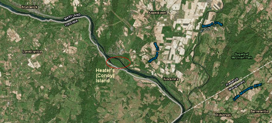
the Piscataways that had lived on Conoy (now Heater's) Island from 1699 until perhaps 1718 could not return even if they had wanted to, after the 1722 Treaty of Albany blocked the Iroquois and subordinate tribes from living east of the Blue Ridge
Map Source: ESRI, ArcGIS Online
the later Virginia interpretation of the 1722 treaty at Albany was that the Iroquois had ceded claims to the Shenandoah Valley, when they agreed not to cross "the great Ridge of Mountains which extend along your Frontiers"
Source: Lewis Evans, A general map of the middle British colonies, Library of Congress
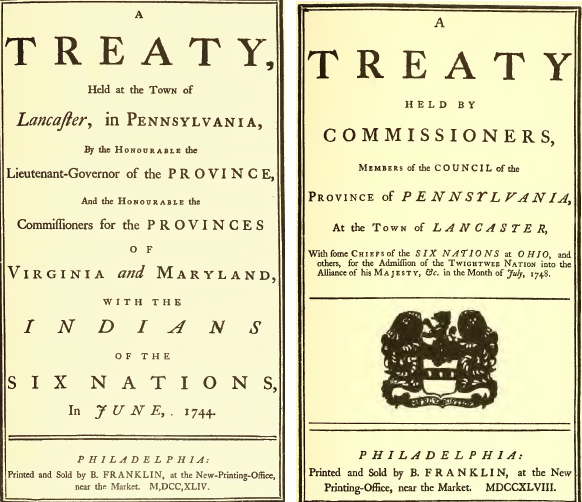
- 1744 Treaty of Lancaster
- - negotiations started after 1742 fight ("Massacre of Balcony Downs") between Iroquois and colonial settlers near the confluence of the Maury and James rivers, in which Captain John McDowell (surveyor of the Borden Grant) died
- - in 1742 the Virginians had not recognized passes issued to Iroquois by Pennsylvania officials for safe passage to go fight Catawbas; a nearby stream is still known as Battle Run13
- - in Treaty of Lancaster, Iroquois sold Virginia their claims to lands west of the Blue Ridge, making a:
- Disclaimer and Renunciation of all their Claim or pretence of Right whatsoever of the said six nations and an acknowledgement of the Right of our Sovereign the King of Great Britain to all the Land in the said Colony of Virginia...
- ...the said Sachims or Chiefs on behalf of the said Six Nations Do hereby renounce and disclaim not only all the Right of the said Six Nations but also recognize and acknowledge the Right and Title of our Sovereign the King of Great Britain to all the Land within the said the said Colony as it is now or hereafter may be peopled and bounded by his said Majesty our Sovereign Lord the King
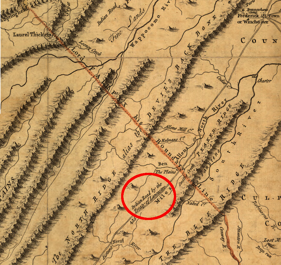
- - 1744 negotiations were required because Iroquois had interpreted 1722 Treaty of Albany phrase "the great Ridge of Mountains which extend along your Frontiers" to be the Blue Ridge, defining a natural barrier separating colonial vs. Native American territory
- - Virginians argued in 1744 that 1722 Treaty of Albany permitted colonial settlement beyond Blue Ridge in the "Back Parts" of Virginia as far as colonial boundaries stretched, and the only the Virginia-allied tribes had been blocked from moving westward across the mountains:
- the white People [are not] prohibited to pass and settle to the Westward of the Great Mountains. It is the Indians tributary to Virginia, that are restrained, as you and your tributary Indians are from passing to the Eastward of the same Mountains, or to the Southward of the Cohongorooton
- - during negotiations, Iroquois described how the 1722 Treaty of Albany had failed to eliminate conflict because colonists settled on lands west of the Blue Ridge:
- You may remember, that about twenty years ago you had a treaty with us at Albany, when you took a belt of wampum, and made a fence with it on the Middle of the Hill [which the Iroquois considered to be the Blue Ridge], and told us, that if any of the warriors of the Six Nations came on your side of the Middle of the Hill, you would hang them; and you gave us liberty to do the same with any of your people who should be found on our side of the Middle of the Hill. This is the Hill we mean, and we desire that treaty may be now confirmed.
- After we left Albany, we brought our road a great deal more to the west, that we might comply with your proposal; but, tho' it was of your own making, your people never observed it, but came and lived on our side of the Hill, which we don't blame you for, as you live at a great distance, near the seas, and cannot be thought to know what your people do in the back-parts: And on their settling, contrary to your own proposal, on our new road, it fell out that our warriors did some hurt to your people's cattle, of which a complaint was made, and transmitted to us by our Brother Onas; and we, at his request, altered the road again, and brought it to the foot of the Great Mountain, where it now is; and it is impossible for us to remove it any further to the west, those parts of the country being absolutely impassable by either man or beast.
- We had not been long in the use of this new road before your people came, like flocks of birds, and sat down on both sides of it...
- - in 1744, "the great Ridge of Mountains which extend along your Frontiers" was clarified to be the Alleghenies - not the Blue Ridge, thus ensuring Iroquois would permit Virginia colonists to settle in the Shenandoah Valley
- - Treaty of Lancaster authorized Iroquois to use the "Great Road" through Shenandoah Valley in order to reach Yadkin River in western North Carolina
- - the English had hoped to arrange peace between Southern Indians (Catawbas) and eliminate the desire of Iroquois to travel south of the Potomac River, but promised to allow travel west of the Blue Ridge:14
- ...if you desire a Road, we will agree to one on the Terms of the Treaty you made with Colonel Spotswood, and your People, behaving themselves orderly like Friends and Brethren, shall be used in their Passage through Virginia with the fame Kindness as they are when they pass through the Lands of your Brother Onas [i.e., Pennsylvania].
- - Iroquois interpreted new boundary of "all the Land in the said Colony of Virginia" (as stated in 1744 Treaty of Lancaster, and later the western boundary of authorized colonial settlement defined in the 1768 Treaty of Fort Stanwix) to be the Ohio River; Iroquois relinquished claims to lands west of Ohio River only after American Revolution in the 1784 Treaty of Fort Stanwix
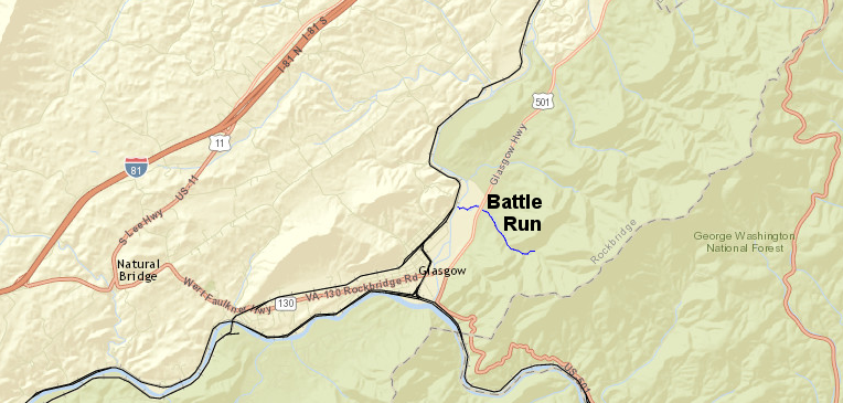
Battle Run was reportedly named for the 1742 fight between colonists and Iroquois
Source: ESRI, ArcGIS Online
in 1744, the Treaty of Lancaster authorized the Iroquois to travel through the Shenandoah Valley to reach the Yadkin river, crossing the Blue Ridge at the Roanoke River water gap
Source: Library of Congress, A map of the most inhabited part of Virginia containing the whole province of Maryland with part of Pensilvania, New Jersey and North Carolina (by Joshua Fry/Peter Jefferson, 1751)
- 1747 Treaty of Philadelphia
- - Native Americans in Ohio River valley surprised colonists by appearing uninvited in Philadelphia and requesting British military action against the French
- - delegation consisted of young "nephews" of older "uncles" in Six Nations, warriors rather than chiefs, and not authorized by Iroquois based in New York to make deals with colonial leaders
- - delegation made clear that Iroquois direction from New York to stay neutral in King George's War had been rejected in Ohio River valley: "the young Indians, the Warriors, and Captains, consulted together, and resolved to take up the English Hatchet against the Will of their old People, and to lay their old People aside, as of no Use but in Time of Peace15
- - Ohio River valley Native Americans were rebelling against Iroquois efforts to dominate lands west of New York, and in competition with the center of Iroquois decision-making at Onondaga had chosen to "kindle a fire" on the Ohio River
- - western Native Americans were frustrated by temporary lack of trading goods and gifts from French at Niagara and Detroit, caused by English navy's effective blockade of trade between France and St. Lawrence River during King George's War
- - key Native American leader of 1747 delegation at Philadelphia was Scaroudy, a member of Oneida nation who lived on Ohio River and served as liaison with Six Nations in New York; key colonial interpreter/negotiator advising the Council of Pennsylvania was Conrad Weiser
- - Pennsylvanians saw opportunity to establish direct trade with western tribes, increasing profits in Pennsylvania by cutting Six Nations and Governor-General of New York out of deals
- - 1747 Native American trip to Philadelphia succeeded in arranging for more direct negotiations16
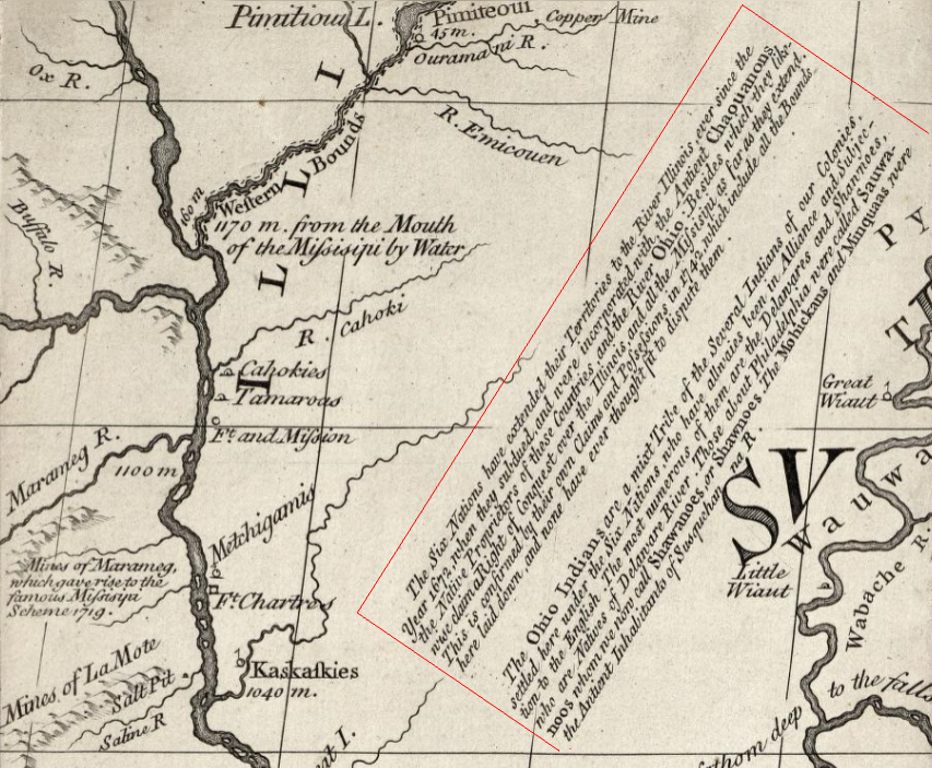
in their diplomatic disputes with the French during the 1700's, the English claimed that they had gained control over the Iroquois and by Right of Conquest had the legal right to all lands under Iroquois control
Source: Yale University, A Map of the country of the Five Nations, belonging to the province of New York; and of the lakes near which the nations of far Indians live, with part of Canada (by Cadwallader Colden, 1747)
- 1748 Treaty of Lancaster
- - two conferences were held at Lancaster, Pennsylvania following the end of King George's War, during which English traders had gained influence because the French could not ship new trade goods across the Atlantic Ocean for Native American customers in the interior of North America
- - Pennsylvania traders sought to bypass the control exerted by the Governor-General in New York ("Corleaer"), so conferences held at Lancaster Pennsylvania rather than at the traditional "council fire" in Albany New York
- - Native American groups in Ohio River valley, supposedly under the authority of the Six Nations, sought to bypass that authority and create a separate confederacy to deal directly with Pennsylvania traders
- - Native American leaders Scaroudy and Tanaghrisson (based at Logstown) were known as "Half-Kings" in Ohio River valley, because they were not authorized by Six Nations in New York to negotiate final deals directly
- - at initial April, 1748 conference, Maryland declined to participate and Virginia relied on Conrad Weiser (who was Pennsylvania's Indian agent) to distribute gifts rather than send a Virginian
- - initial deal granted only Pennsylvania the rights to land and trade, triggering Virginia and Maryland to attend a "do-over" in July, 1748
- - July conference gave rights to the Maryland, Virginia, and Pennsylvania colonies without clarifying how each would define its claims
- - conference established a Chain of Friendship between Pennsylvania-Ohio River groups (including "Twightwee" or Miami), separate from Covenant Chain created between New York-Six Nations17
Benjamin Franklin printed copies of treaty documents, including the speeches of the negotiators
Source: Internet Archive, Indian treaties printed by Benjamin Franklin, 1736-1762

until the English expelled the French from North America in 1763, the English claim to western lands was based on their conquest of the Iroquois and the claim that the Iroquois had established an empire with control over western tribes
Source: Library of Congress, A map of the British and French dominions in North America (by John Mitchell, 1774)
- 1752 Treaty of Logstown
- - Logstown/Logg's Town emerged in the late 1740's as the key location for trade and negotiations between agents of the Pennsylvania/Virginia colonies and leaders of the Mingos, Shawnee, and Delawares (Lenape) in the upper Ohio River Valley
- - Mingo headman Tanaghrisson (the Half King) and Virginia/Pennsylvania traders combined efforts to block attempts by the Wyandots, an Iroquoian-speaking group who had moved from French-controlled Detroit into the Beaver River Valley, to have negotiations occur at their town of Kuskusky (near modern New Castle, Pennsylvania)
- - in 1749 the Ohio Company established its base on the Potomac River at Wills Creek (modern Cumberland, Maryland) and sought to gain some sort of approval by the Iroquois for colonial settlement
- - in 1750-51, Virginia and Pennsylvania agents (Christopher Gist, George Croghan, and Andrew Montour) traveled through the Ohio Country and convinced various groups to come to Logstown for treaty negotiations. It helped that French traders based in Canada and Detroit were offering inferior goods at higher prices, and French officials were demanding to have excessive control over local tribes.
- - in 1752, commissioners representing both Virginia and the Ohio Company (including James Patton) negotiated primarily with Tanaghrisson to get authorization for the Ohio Company to build a blockhouse at the confluence of the Allegheny and Monongahela rivers (Forks of the Ohio)
- - George Croghan, as the Pennsylvania interpreter/representative, supported the primacy of Virginia authority to make the deal because Pennsylvania would not honor his side arrangement to claim 200,000 acres in his own name
- - Tanaghrisson feared negotiators would bypass him and deal directly with Shawnee/Delaware leaders, if he continued to oppose construction of Ohio Company blockhouse
- - Tanaghrisson claimed to act as the representative of the Iroquois Confederacy, and told colonial negotiators that he had crowned Shingas as a Delaware "king"
- - the Delaware chief, Shingas, asserted he had independent authority as he approved the treaty that limited Delaware and Shawnee claims south of the Ohio River
- - the Iroquois never ratified the treaty before the French and Indian War interrupted dealings between colonists and Native Americans
- - the Ohio Company sent William Trent in 1753 to build a fort (named Fort Prince George and also Trent's Fort) at the confluence of the Alleghany and Monogohela rivers
- - the French response to the treaty was to send a force to build chain of forts from Lake Erie into Ohio River Valley, including Presqu'ile, Fort le Boeuf, and eventually Fort Duquesne
- - Governor Dinwiddie sent a force led by George Washington to protect the Ohio Company fort at the forks of the Ohio River. On the journey, Washington's men attacked French troops who were asleep at what is now called Jumonville Glen. The "assassination" of the French leader there triggered the French and Indian War.18
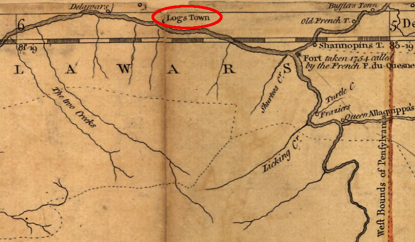
Logg's Town was established around 1748 by the Seneca headman Tanaghrisson, downstream from the Forks of the Ohio (where the French built Fort Duquesne)
Source: Library of Congress, A map of the most inhabited part of Virginia containing the whole province of Maryland with part of Pensilvania, New Jersey and North Carolina (by Joshua Fry/Peter Jefferson, 1751)
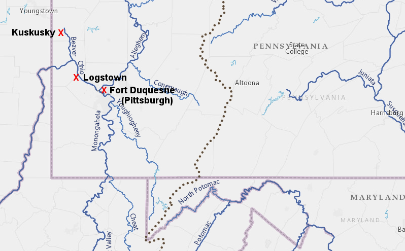
the rival town of the Wyandot's was Kuskusky on the Beaver River, but George Croghan, Conrad Weiser, and Cristopher Gist insisted on doing business at Logg's Town with Tanaghrisson as the representative of the Iroquois Confederacy
Source: ESRI, ArcGIS Online
- 1754 Albany Congress
- - Lord Halifax and other officials in London anticipated the 1748 Treat of Aix-la-Chapelle would not hold and war would erupt again between England and France
- - in 1753 the Board of Trade directed colonial governors of New Hampshire, Massachusetts Bay, New York, New Jersey, Pennsylvania, Maryland, and Virginia to convene a joint meeting with the Iroquois and resolve their complaints together:19
- take care that all the Provinces be (if practicable) comprized in one general Treaty to be made in his Majesty's name it appearing to us that the practice of each province making a separate Treaty for itself in its own name is very improper and may be attended with great inconveniency to his Majesty's service.
- - Benjamin Franklin, a negotiator for Pennsylvania, advanced a plan of union for the colonies modelled in part on the confederation between the Six Nations; included a President-General appointed by the monarch in England and a Grand Council chosen by the colonial assemblies and meeting at least annually, union would centralize negotiation of all treaties with Native Americans; provincial assemblies opposed loss of colonial authority while London officials focused on just the war effort20
- - Virginia sent no representative to Albany meeting; Conrad Weiser (interpreter for Pennsylvania) represented Virginia's interests
- - Connecticut's Susquehanna Company purchased land directly from Iroquois even though it was located within the boundaries of Penn's patent, and Pennsylvania representatives also made a separate land purchase for that colony21
- - the Covenant Chain was "brightened" at Albany, but that did not succeed in uniting the Six Nations on the British side during the French and Indian War
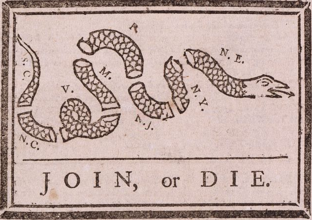
Benjamin Franklin illustrated his argument made at Albany in 1754 for a colonial union with a graphic editorial
Source: Library of Congress, Join or Die (illustration in The Pennsylvania Gazette, May 9, 1754)
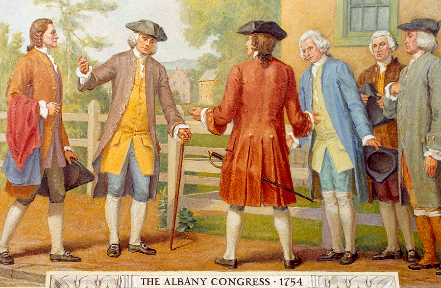
in 1754 Benjamin Franklin (second from left, leaning on cane) discussed the Plan of Albany uniting the colonies with his son William Franklin from New Jersey (far left) and others, including the men on his right - Governor Thomas Hutchinson (Massachusetts), Governor William Delancey (New York), Sir William Johnson (Massachusetts), Colonel Benjamin Tasker (Maryland)
Source: Architect of the Capitol, The Albany Congress, 1754
- 1758 Treaty of Easton
- - since Braddock had been defeated at the start of the French and Indian War three years earlier, colonial leaders in Pennsylvania wanted to ensure both the Delaware (Lenape) and Ohio Country tribes would not support the French
- - attempts in 1756 and 1757 to convince tribes to ally with British, or at least to stop raiding western settlements, failed
- - by 1758, British Navy had finally blocked the French from supplying guns, gunpowder, and other trade items to the Native Americans in Ohio Country
- - Native Americans wanted English colonists to honor previous commitments to keep settlers out of region once French were expelled
- - treaty signed at eastern Pennsylvania at Forks of the Delaware River (Easton) after two years of negotiations, just before French abandoned Fort Duquesne as General Forbes approached
- - Sir William Johnson, British Superintendent of Indian Affairs in the Northern District, and Six Nations (Iroquois) treated Delaware in negotiations as subordinate to Iroquois, in part because erratic Delaware leader Teedyuscung got drunk
- - Johnson said the Ohio River watershed divide would be the western limit of colonial expansion, and promised to reserve Ohio River watershed as Native American territory
- - British succeeded in capturing Fort Duquesne in part because Native American allies deserted the French after learning of the just-negotiated Treaty of Easton
- - English failed to fulfill promise in Treaty of Easton to reserve Ohio River watershed for Native Americans and built forts west of Fort Pitt
- - failure to keep settlers away from Ohio River led to Pontiac's Rebellion in 1763, when General Jeffrey Amherst sent blankets used by smallpox patients to infect the Delaware22
the Six Nations - Seneca, Cayuga, Onondaga, Tuscarora, Oneida, and Mohawk - maintained a peace called the Covenant Chain with the English from the 1670's until the outbreak of the French and Indian War in 1753
Source: Map of the Iroquois confederacy, 1736-1762 (frontispiece to Indian treaties printed by Benjamin Franklin, 1736-1762, 1938 edition)
- 1763 Treaty of Paris
- - after military defeat in the French and Indian War, the French ceded claims to lands north of the Ohio River (including Canada) to the English and transferred control over the Louisiana Territory to Spain
- - English begin to cite Treaty of Paris as basis for their claim to Northwest Territory, replacing old claim that English controlled the land by Right of Conquest over Iroquois23
the Virginians claimed the Iroquois had defeated tribes west to the Mississippi, and the Virginians acquired rights to that territory from the Iroquois
Source: A New and Accurate Map of North America (Carington Bowles, 1771)
- The Proclamation of 1763
- - issued after Great Britain gained control over New France, from the Atlantic Ocean to the Mississippi River
- - created Government of Quebec to manage French Catholics living along St. Lawrence River, and stated Quebec would have an elected General Assembly comparable to existing English colonies in North America
- - banned colonial settlement west of the Eastern Continental Divide, including the Holston River, New River, Greenbriar River and other parts of the Ohio River watershed, and required settlers already there "forthwith to remove themselves from such Settlements"24
- - created Indian Reserve, including "all the Lands and Territories lying to the Westward of the Sources of the Rivers which fall into the Sea from the West and North West"
- - authorized only imperial officials to negotiate for purchase of land within Indian Reserve, and banned private deals between Native American tribes and colonists/colonial governments ("if at any Time any of the Said Indians should be inclined to dispose of the said Lands, the same shall be Purchased only for Us")
- - intended to minimize conflicts with Native Americans (such as Pontiac's Rebellion) by eliminating colonists' intrusion into traditional hunting territories, and thus minimize costs of military protection on western frontier
- - spurred colonial officials and land speculators such as Ohio Company/Loyal Land Company to negotiate land cessions by Iroquois and Cherokee, in theory opening lands to legitimate colonial settlement without triggering Native American conflict (but Shawnee, Mingo, Delaware, and other Native American groups did not concur with later treaties granting rights to settle as far west as the mouth of the Tennessee River)

the Proclamation Line of 1763 created and Indian Reserve, but British officials and colonial leaders then authorized new treaties that moved the settlement line further west
Source: Library of Congress, Cantonment of His Majesty's forces in N. America according to the disposition now made & to be compleated as soon as practicable taken from the general distribution dated at New York 29th. March 1766
- 1764 Treaty of Fort Niagara
- - the Treaty of Paris ended the Seven Years War in 1763 (known in America as the French and Indian War and in Canada as The Conquest), and by terms of the treaty the French-speaking habitants, seigneurs, and clergy in New France became British subjects.
- - France had not negotiated formal treaties to document land cessions in the St. Lawrence River valley from Native American occupants to seigneurs or (after 1663) to the French crown. The King of France granted lands near French forts to religious orders, such as the Ursuline nuns in Quebec City, without acquiring title to those lands through treaties with local tribes. The religious orders then authorized settlers to use different parcels. (For example, the Ursuline order allowed Abraham Martin to graze his livestock on the "Plains of Abraham," where the French and English fought outside Quebec City in 1759.)
- - Proclamation of 1763 acknowledged Native American ownership of lands in New France that Britain acquired in Treaty of Paris, and Treaty of Fort Niagara was the first formal document to transfer lands to British ownership
- - after issuing the Proclamation of 1763 the British required formal treaties with the Native Americans in North America before authorizing settlement on acquired lands (since 1607, colonies mostly ignored/finessed need for any formal legal transfers of Native American land claims)
- - series of negotiations with over 2,000 Native Americans representing 24 nations (including the six Iroquois Nations and many groups living west of Fort Niagara at start of St. Lawrence River - but not the Shawnee or Delaware) strengthened "Covenant Chain" with the exchange of wampum belts
- - British purchased rights to use a four mile strip of land on the Niagara River linking Lake Ontario with Lake Erie, starting chain of title and setting the pattern for British acquisition of land from the First Nations of Canada25
- 1768 Treaty of Hard Labor
- - Pontiac's War in 1763-65 made clear that the British needed to negotiate boundaries with Native Americans; the Proclamation of 1763 alone would not reassure Native American tribes that colonial expansion would block future intrusions into traditional territories
- - British Superintendent of Indian Affairs, Southern Department (John Stuart) was the official British representative who dealt with Cherokee to define new colonial/Native American boundaries
- - the Board of Trade in London authorized Stuart in advance of negotiations to adjust the settlement boundary established in the Proclamation of 1763, moving line of colonial settlement further west to mouth of Kanawha River
- - Virginia's Governor Botetourt directed two Virginia negotiators to move the line further west than John Stuart planned, since the colony had already issued land grants in the area (including the 800,000-acre grant to the Loyal Land Company, the 100,000-acre grant to the Greenbrier Company, and the 100,000-acre Wood's River Grant to Col. James Patton):26
- the principal object of your journey is to convince Mr. Stuart that the Line he proposes to run from Chiswell's mine to the mouth of the Great Konhaway,
will so much contract the limits of this Colony, as to make it extremely prejudicial to His Majesty's Service, as well as injurious to the people who have been encouraged to settle to the Westward of his propos'd Boundary.
- - treaty was negotiated at place in South Carolina (Hard Labor), midway between Charleston and Cherokee towns on upper Savannah River
- - Cherokee ceded claims to land in western Virginia south of Ohio River, downstream to the mouth of the Kanawha River
- - new settlement boundary defined by straight line from mouth of Kanawha River southeast to Chiswell's lead mine (modern Austinville, Virginia) rather than using the Kanawha River itself as the boundary, thus authorizing colonial settlement on some lands west of New River (including William Ingles' ferry, where I-81 now crosses the New River)
- - another straight line defined edge of acceptable settlement, extended southwest from Chiswell's mine to a point in the Blue Ridge on the North Carolina/South Carolina border (reaffirming previous agreements with Carolinians regarding lands east of the Blue Ridge)
- - treaty retained Cherokee claims to most lands southwest of Kanawha river, including that part of Virginia southwest of modern Pulaski/Carroll counties already occupied by settlers such as Samuel Stalnaker
- - Superintendent of Indian Affairs John Stuart bluntly rejected Virginia's requests to move treaty line west to confluence of Ohio River and Cherokee (Tennessee) River, asserting that settlers had moved illegally into Cherokee lands after Proclamation of 1763 and stating:27
- There is nothing more certain than that the Cherokees have and still do claim the Lands between the Kanhaway and the Cherokee river, and I am convinced they never will relinquish their claims to the extent of the wishes of the House of Burgesses of Virginia
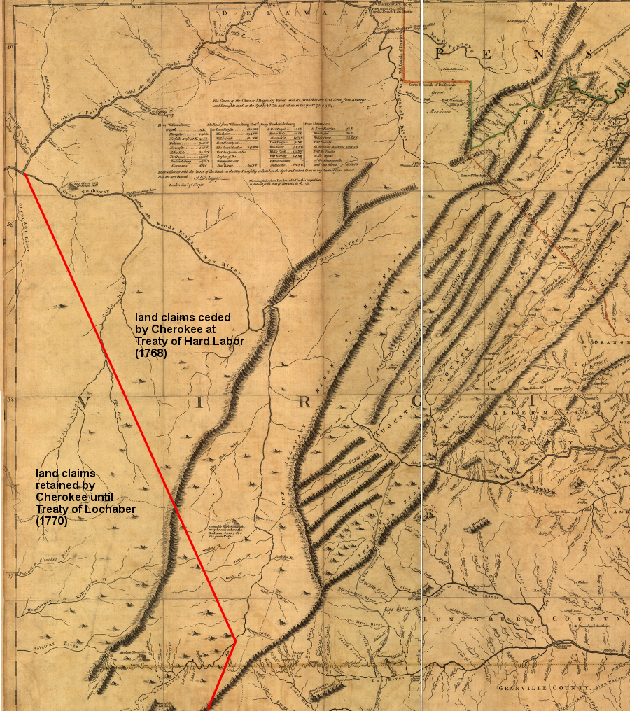
the Cherokee did not agree to abandon their claim to southwestern Virginia and Kentucky in the 1768 Treaty of Hard Labor
Source: Library of Congress, A map of the most inhabited part of Virginia containing the whole province of Maryland with part of Pensilvania, New Jersey and North Carolina. Drawn by Joshua Fry & Peter Jefferson in 1751
the 1768 Treaty of Hard Labor still left much of Virginia west of an authorized line of settlement
Source: Historical Maps of Pennsylvania, 1768.9
- 1768 Treaty of Fort Stanwix
- - British Superintendent of Indian Affairs, Northern Department (Sir William Johnson) was the official British representative who dealt with Iroquois to define new colonial/Native American boundaries in 1768 Treaty of Fort Stanwix
- - British prepared for treaties with both Cherokee and Iroquois in 1768; Cherokee chiefs traveled to William Johnson's home in Iroquois territory and negotiated peace deal between those two nations before negotiations opened for 1768 Treaty of Fort Stanwix with Iroquois and 1768 Treaty of Hard Labor with Cherokee
- - Board of Trade agreed in advance to modify boundary of colonial settlement west, past the line defined in Proclamation of 1763; authorized British officials to acquire claims to land west to Ohio River as far down as mouth of the Kanawha River
- - two representatives from Virginia, Dr. Thomas Walker (investor in Loyal Land Company) and Andrew Lewis (investor in Greenbrier Company), were land speculators with personal interests for extending settlement boundary, wanted authorization for colonists to acquire land beyond Kanawha River in Kentucky
- - English affirmed Iroquois claims to western New York; Iroquois abandoned their claims to lands east and south of Ohio River (which Iroquois used only for hunting and raiding against other tribes)
- - colonial land speculators succeeded in efforts to push western settlement boundary past limit authorized by Board of Trade (mouth of Kanawha River); treaty relinquished Iroquois claims for another 350 miles further west, downstream to confluence of Ohio and "Cherokee" (Tennessee) rivers
- - Six Nations of Iroquois claimed authority to sign treaty for dependent nations; Iroquois claimed those groups were obliged to comply but the Delaware, Shawnee, Mingo, Wyandot, and Ottawa did not sign the treaty on their own
- - Cherokee were not involved in Treaty of Fort Stanwix negotiations, but released their claims to some of the same lands in the 1768 Treaty of Hard Labor and later in 1770 Treaty of Lochaber
- - Shawnee had claims to territory being ceded by Iroquois and Cherokee and were not parties to 1768 Treaty of Fort Stanwix, 1768 Treaty of Hard Labor, or 1770 Treaty of Lochaber, but in 1774 (after Virginia's colonial governor launched Dunmore's War and the Virginians under Andrew Lewis won the Battle of Point Pleasant) Shawnee and other groups were forced to abandoned their claims to those lands south of Ohio River in the Treaty of Camp Charlotte
the Treaty of Fort Stanwix moved the Proclamation Line of 1763 boundary west from the ridgeline of the Alleghenies to the Ohio River - according to the Iroquois
Source: National Park Service, Casemates and Cannonballs: Archeological Investigations at Fort Stanwix National Monument (Chapter 2)
the Board of Trade authorized colonial officials to negotiate with the Cherokee and the Iroquois to permit settlement west of the Proclamation of 1763 line down to the mouth of the Kanawha River (green line), but in the 1768 Treaty of Fort Stanwix the Iroquois ceded their claims to lands south of the Ohio River all the way to mouth of the Tennessee River (red line)
Source: ESRI, ArcGIS Online
Virginia land speculators anticipated the 1768 Treaty of Fort Stanwix would revise the boundary of settlement established in the Proclamation of 1763, opening up the lands south of the Ohio River down to the Kanawha ("Konhaway") River
Source: Library of Congress, A new and accurate map of Virginia wherein most of the counties are laid down from actual surveys. With a concise account of the number of inhabitants, the trade, soil, and produce of that Province (John Henry, 1770)
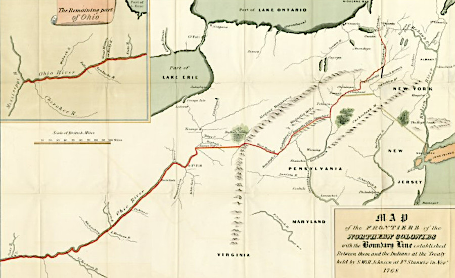
in 1768, the Iroquois claimed the right to authorize colonial settlement west to the Mississippi River
Source: University of Pittsburgh, Map of the frontiers of the northern colonies (John Henry, 1770)
- 1770 Treaty of Lochaber
- - Virginia negotiators at 1768 Treaty of Hard Labor could not overcome opposition of Superintendent of Indian Affairs John Stuart, who refused to request that Cherokee cede control over lands between mouths of Kanawha and Tennessee rivers (even though Iroquois had abandoned their claims in the 1768 Treaty of Fort Stanwix)
- - Virginia negotiators did reach agreement with Cherokee for a second round of negotiations to authorize existing settlements on Holton River valley; those negotiations occurred at Alexander Cameron's plantation called Lochaber in South Carolina two years later
- - Col. Andrew Lewis and Dr. Thomas Walker were directed by Lord Botetourt to request Cherokee to cede title to more lands in western Virginia between Blue Ridge and Alleghenies, in New River valley plus lands drained by upper tributaries of Tennessee River
- - House of Burgesses appropriated ٠,500 in December, 1769 to help British Superintendent of Indian Affairs (Southern Department) John Stuart get Cherokee to agree to agree to cede land east of the mouth of the Great Kanawha
- - at Lochaber, southern end of line from mouth of the Kanawha River was moved from Chiswell's mine westward, to a point near Long Island on the Holston River
- - John Stuart proposed Long Island as southern end point of new boundary; John Donelson represented Gov. Botetourt
- - Cherokee (including Oucconnastotah and Attakullakulla) refused to give up control over Long Island, so English agreed to a southern endpoint six miles east of Long Island
- - southern boundary was defined as the projected location of Virginia-Carolina border (36° 30"), once it was drawn further west from Steep Rock Creek into Tennessee River valley; settlers on Holston River thought they were in Virginia
- - in 1770 the latitude of the Virginia-Carolina border was not defined at Holston River, because Peter Jefferson and Joshua Fry had stopped surveying further east at the Blue Ridge in 1749
- - in October 18, 1770 Treaty of Lochaber, Cherokee relinquished claims to a wedge of lands north of the Virginia-Carolina border (36° 30") and authorized Virginians to settle along Holston River south down to Virginia-Carolina border, but Cherokee did not formally cede lands south of the Carolina border
- - after formal agreement was reached, surveyor Anthony Bledsoe determined that Virginia-Carolina border lay north of existing settlements on South Fork of Holston River, so Cherokee informally granted colonists the right to settle south of the border down to latitude of Long Island
- - other informal negotiations granted colonists the right to settle as far west as the mouth of the Kentucky River rather than Kanawha River, bypassing Stuart's negotiations and partially accepting Virginia's desire to authorize settlement west to mouth of Tennessee River (as Iroquois had done in 1768 Treaty of Fort Stanwix)
- - John Donelson surveyed an "Indian Line" in 1771 that supposedly represented Treaty of Lochaber line north from Virginia-Carolina border to mouth of Kanawha River, but actually went from Holston River to mouth of the Kentucky River
- - settlements at Watauga, Nolichucky, and Carter's Valley were further south of line recognized as Virginia-Carolina border, and were not authorized by Cherokee or British officials28
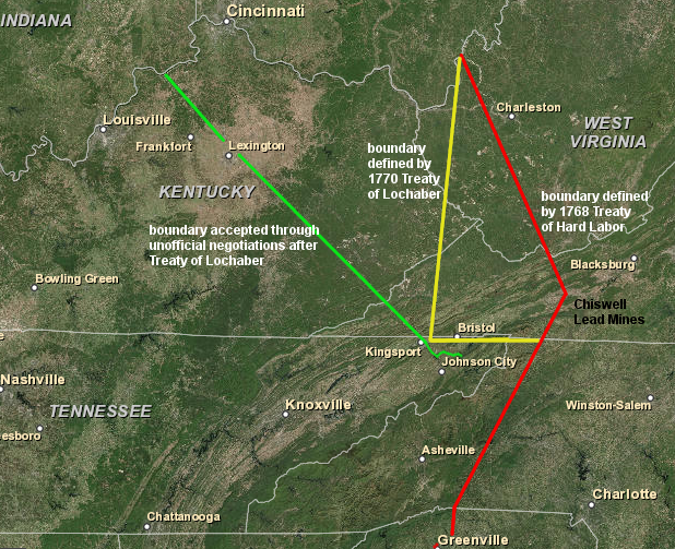
the 1768 Treaty of Hard Labor and 1770 Treaty of Lochaber expanded the territory controlled by Virginia, while reducing the extent of the Cherokee hunting grounds
Source: ESRI, ArcGIS Online
- 1774 Treaty of Camp Charlotte
- - surveyors for land speculators in western Virginia were harassed by the Shawnee, while colonists created their own incidents (including Colonel Cresap's murder of the family of Mingo chief Logan)
- - Governor Dunmore decided to invade Shawnee-controlled territory; war allowed him to divert attention from anti-British revolutionary activities in Massachusetts and to prevent Pennsylvania from establishing a stronger claim to trans-Ohio territory
- - Virginia troops led by Andrew Lewis defeated Shawnee led by Cornstalk and other Native Americans at Point Pleasant near mouth of Kanawha River
- - Shawnee recognized they could not defend towns against columns led by Lewis and Dunmore, so accepted terms at Camp Charlotte (near today's Chillicothe, Ohio)
- - Logan refused to attend negotiations at Camp Charlotte, but spoke separately and Thomas Jefferson made his speech famous in Notes on the State of Virginia
- - Mingo resisted longer, until towns were destroyed
- - no document with all treaty terms has survived, but Dunmore reported that Shawnee agreed at Camp Charlotte to his terms:29
- the Indians should deliver up all prisoners without reserve; that they should restore all horses and other valuable effects which they had carried off; that they Should not hunt on our Side the Ohio, nor molest any Boats passing thereupon; That they Should promise to agree to such regulations, for their trade with our People, as Should be hereafter dictated by the Kings Instructions, and that they Should deliver into our hands certain Hostages, to be kept by us untill we were convinced of their Sincere intention to adhere to all these Articles...
- ...and in return I have given them every promise of protection and good treatment on our Side.
- 1774 Quebec Act
- - the British revised the Proclamation of 1763, expanding the boundaries of the Province of Quebec
- - the colonists in America considered granting religious freedom to Catholics and blocking the ability to speculate in western lands to be one of the "Intolerable Acts"
- 1775 Fort Pitt agreement
- - once American Revolution had started, Continental Congress directed Patrick Henry, Benjamin Franklin, and James Wilson to ensure peace on western frontier
- - Iroquois (claiming to represent western tribes, including Mingo, Wyandot, and Shawnee) and Delaware representatives agreed to stay neutral30
- 1775 Treaty of Sycamore Shoals/Treaty of Watauga
- - after Shawnee had been defeated in Lord Dunmore's War (1774), Cherokee anticipated that British settlers would be more aggressive in evading Proclamation of 1763
- - Richard Henderson and the Transylvania Company purchased 20 million acres from the Cherokee, acquiring the territory north of the Cumberland River, south of the Ohio River, and west of the Kentucky River
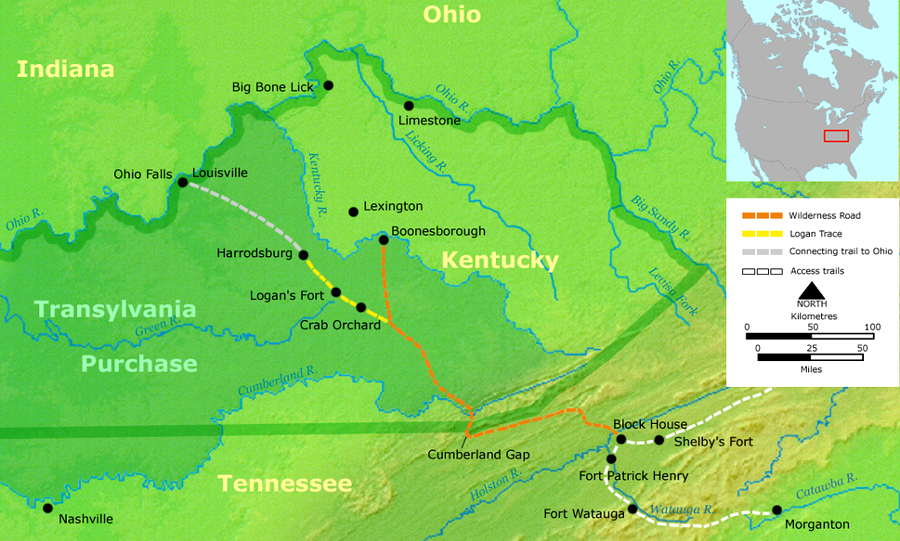
- - Path Deed was separate but simultaneous purchase of lands between Holston River and new Transylvania Purchase; Henderson needed that territory to legitimize the Wilderness Road going from Long Island of the Holston River (now Kingsport, Tennessee) to Cumberland Gap
- - in the Path Deed, Cherokee Chiefs Attacullaculla, Oconistoto, and Savanooko sold to the Transylvania Company the traditional Cherokee town at Long Island of the Holston River that had been retained in 1770 Treaty of Lochaber
- - Cherokees also authorized colonists to live in settlements along the Watauga and Nolichucky rivers
- - Dragging Canoe refused to concur with the 1775 treaties, unlike his father Attakullakulla (Little Carpenter), and warned that Kentucky would be a "dark and bloody ground"
in the 1775 Treaty of Sycamore Shoals, the Cherokee sold lands north of the Cumberland River where they had no towns and thin claims to ownership
Source: Wikipedia, Sycamore Shoals
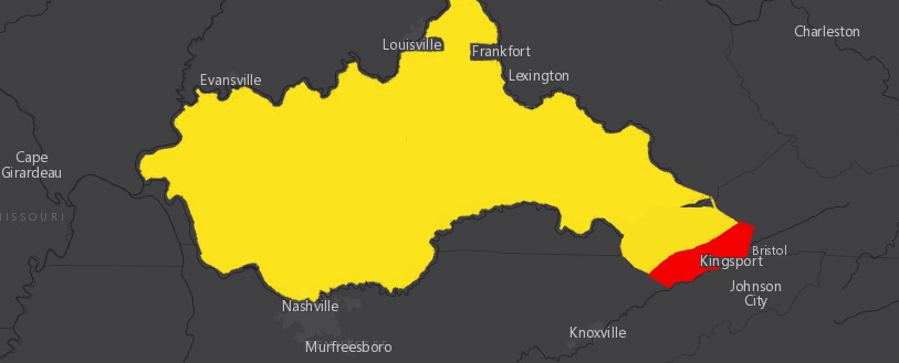
the Path Deed that was signed with the 1775 Treaty of Sycamore Shoals included the lands between the Holston River and Powell Mountain (shown in red), allowing access to Cumberland Gap and the Transylvania purchase (shown in yellow)
Map Source: ESRI, ArcGIS Online
- 1777 Treaty of Long Island/Treaty of Holston
- - in 1776, Shawnee chief Cornstalk met with leaders of Cherokee and other tribes at Chota to ally with British in fight against settlers, and Dragging Canoe accepted war belt
- - some Cherokee warriors raided isolated farmsteads from Carter's Valley on Holston River to Clinch River
- - in Battle of Island Flats, Dragging Canoe and Overhill Cherokee were unable to capture Fort Lee at Long Island of the Holston River; Fort Caswell/Fort Watauga on the Watauga River withstood a two-week siege
- - militia forces from South Carolina, North Carolina, and Georgia organized and destroyed the Lower Towns of the Cherokee
- - William Christian led forces from Virginia against the Overhill Towns, but Dragging Canoe burned them and fled with followers to Chickamauga
- - Attacullaculla, Oconistoto, and Savanooko tried to negotiate peace with Virginia and North Carolina at Fort Patrick Henry on March 20, 1777, but Dragging Canoe would not participate
- - Treaty of Long Island finally signed July 20, 177 at Fort Henry on Long Island of the Holston
- - Cherokee abandoned all claims to southwestern Virginia, and once again ceded the traditional Cherokee town at Long Island of the Holston River and a corridor to Kentucky through Cumberland Gap
- - Cherokee signed separate Treaty of Dewitt's Corner with South Carolina on May 20, 1777, in which Upper Town chiefs ceded lands east of Blue Ridge down to current Georgia-South Carolina border (including most of the Lower Towns, without the consent of the Cherokee leaders there)31
Cherokee land cessions between 1768-1785 included parts of Virginia
Source: Charles C. Royce, Cherokee Land Cessions
- 1778 Treaty of Fort Pitt
- - Delaware granted rebellious Americans access through their claimed territory, between Allegheny River on east and Hocking/Sandusky rivers on west, to attack British fort at Detroit
- - Americans made offer to Delaware and "other tribes who have been friends to the interest of the United States, to join the present confederation, and to form a state whereof the Delaware nation shall be the head, and have a representation in Congress"32
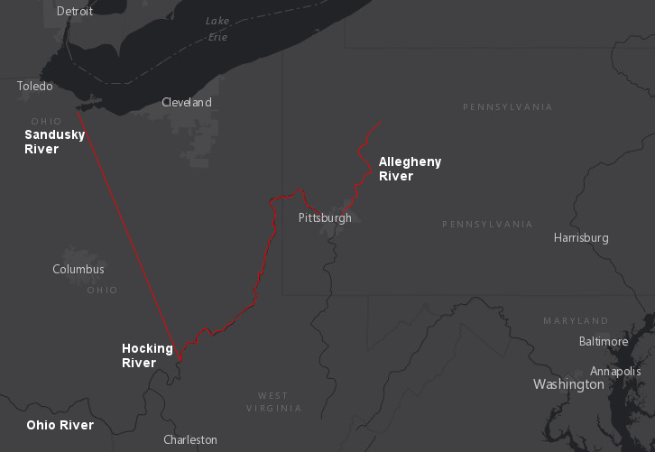
the 1778 Treaty of Fort Pitt was the first treaty with Native Americans ratified by the Continental Congress, and the Delaware granted permission to cross their lands between the Allegheny River on east and the Hocking/Sandusky rivers on the west
Source: ESRI, ArcGIS Online
- 1783 Treaty of Paris
- - Americans, Great Britain, and France negotiated end to American Revolution
- - in treaty with 13 states, Great Britain ceded control over lands extending west to Mississippi River between Canada and south to Spanish territory at 31° latitude
- - no Native American tribe participated in decisions regarding sovereignty of lands where they lived
- 1784 Treaty of Fort Stanwix
- - after Revolutionary War, Americans attempted to minimize conflicts in Northwest Territory by separating settlers from Native Americans and defining lands where each group would live
- - since 1783 Treaty of Paris only ended war between Great Britain and 13 former colonies, 1784 Treaty of Fort Stanwix was needed to end conflict with Mohawk, Onondaga, Cayuga and Seneca (within Six Nations, Oneida and Tuscarora had supported American side)
- - Virginia ceded its Northwest Territory land claims to Continental Congress in March, 1784, prior to start of treaty negotiations
- - Federal representatives (including Arthur Lee of Virginia) concluded negotiations reaffirming boundary line in 1768 Treaty of Fort Stanwix, defining lands west of that line as first reservation for Native Americans create by American government
- - Iroquois treated as "subdued nation" conquered by Americans in Revolutionary War, so land seize as reparations and no compensation given to Iroquois33
- - Pennsylvania representatives acquired Iroquois claims within Pennsylvania, so Six Nations reservation was entirely within New York
- - Americans adopted approach used by English after 1763 Treaty of Paris and rejected Iroquois attempt to negotiate for tribes living west of Ohio River based on claims of previous conquest of that area; no Iroquois were at 1795 Treaty of Greenville negotiations34
- 1785 Treaty of Fort McIntosh
- - Iroquois release in 1784 Treaty of Fort Stanwix of lands west of the Ohio River did not end claims by other nations to same Northwest Territory lands
- - American negotiators signed treaty at Fort McIntosh (on Ohio River at mouth of Beaver Creek, 29 miles downstream from Pittsburgh) with Wyandot, Delaware (Lenape), Chippewa (Ojibwa), and Ottawa leaders
- - Americans committed to block settlement between Cuyahoga and Maumee rivers, setting aside a Native American reserve
- - Shawnee, Miami, and others refused to accept cession of eastern and southern Ohio by "unauthorized" leaders and fought Americans in central Ohio for another decade35
the 1785 Treaty of Fort McIntosh was intended to release eastern and southern Ohio for American settlement, while reserving a portion of the Northwest Territory "to the Wiandot and Delaware nations, to live and to hunt on, and to such of the Ottawa nation as now live thereon"
Source: ESRI, ArcGIS Online
- 1785 Treaty of Dumplin Creek
- - Governor Sevier and other State of Franklin negotiators met where Dumplin Creek flows into the French Broad River with a selected group of compliant Cherokee leaders, but key Cherokee leaders such as Old Tassel and Dragging Canoe were not invited
- - Cherokee relinquished claims to "all the lands lying and being on the South side of the Holston and French Broad rivers, as far South as the ridge that divides the water of Little [Tennessee] River from the waters of Tennessee [River]"36
a series of treaties pushed the land claims and hunting grounds of the Cherokee further and further away from Virginia
Source: Library of Congress, "Indian Land Cessions in the United States, 1784-1894," Tennessee and bordering States
- 1785 Treaty of Hopewell
- - Cherokee leaders who refused to go to Dumplin Creek did go to Hopewell, South Carolina to negotiate with agents of Confederation Congress and state of North Carolina
- - far more representative of Cherokee, and 1,000 of them attended
- - declared that Treaty of Dumplin Creek was not valid, and returned control of lands ceded since 1777 (including State of Franklin capital at Greenville)
- - North Carolina and Congress ignored Treaty of Dumplin Creek, and State of Franklin ignored Treaty of Hopewell37
settlers occupying Cherokee land east of the Holston River were granted special consideration in the 1785 Treaty of Hopewell
Source: Library of Congress, Articles of a Treaty...
- 1786 Treaty of Coyatee
- - Cherokee forced to negotiate at Chota Ford, after North Carolina supported military attacks by State of Franklin militia on Overhill Cherokee towns
- - State of Franklin representatives fraudulently claimed North Carolina had sold then all the lands north of Tennessee and Holston rivers
- - Old Tassel and Hanging Maw rejected that argument, but Cherokee forced to sign anyway
- - forced sale of lands north of the Little Tennessee River violated Treatry of Hopewell38
- 1791 Treaty of Holston
- - ended war triggered by State of Franklin officials and land speculators
- - Dragging Canoe and other Chickamauga leaders participated; Cherokee were united in fight after murders of Old Tassel and Old Abraham despite flag of truce at Chilhowie in 1788
- - treaty signed at Knoxville where Holston River joins with Tennessee River
- - Cherokee ceded lands east of the Clinch River and Muscle Shoals, but United States guaranteed remaining land
- - Federal government agreed to provide free farm equipment to encourage Cherokee to become herdsmen and cultivators
- 1795 Treaty of Greenville
- - Shawnee, Miami, and other Native American groups refused to accept the 1785 Treaty of Fort McIntosh, and joined in a Western Confederacy that defeated American military expeditions led into Ohio Country by Major General Josiah Harmar (1790) and Major General Arthur St. Clair (1791)
- - Major General "Mad Anthony" Wayne defeated Western Confederacy in the 1794 Battle of Fallen Timbers near modern Toledo, Ohio
- - after pushing boundary of settlement further west in treaty, US Congress applied the Northwest Ordinance and divided the Northwest Territory for the first time, creating the Indiana Territory
- - Shawnee leader Tecumseh and his brother ("The Prophet") refused to accept Treaty of Greenville, but in 1813 their plans for an independent Native American nation died with Tecumseh at the Battle of the Thames in Canada
Shawnee, Miami, and other members of the Western Confederacy signed the 1795 Treaty of Grenville, after the Battle of Fallen Timbers
Source: William E. Peters, Ohio Lands and Their Subdivision (p.148)
later treaties forced Native Americans to leave that part of Ohio theoretically reserved for them in the 1795 Treaty of Grenville
Source: Library of Congress, Indian land cessions in the United States (by Charles C. Royce, 1899)
- 1798 First Treaty of Tellico
- - Cherokee abandoned more claims to lands in Tennessee
The English used the written word to record the terms of treaties. The Iroquois relied upon their memory, but used designs on wampum belts as a trigger for recalling details. Native American meetings were described by Benjamin Franklin:39
- Having frequent Occasions to hold public Councils, they have acquired great Order and Decency in conducting them. The old Men sit in the foremost Ranks, the Warriors in the next, and the Women and Children in the hindmost. The Business of the Women is to take exact notice of what passes, imprint it in their Memories, for they have no Writing, and communicate it to their Children. They are the Records of the Council, and they preserve Tradition of the Stipulations in Treaties a hundred Years back, which when we compare with our Writings we always find exact.
the Iroquois and other tribes north of the Potomac River negotiated with long, often repetitive discussions and shared wampum belts to memorialize the statements, while the English documented the decisions with words on paper
Source: Library of Congress, The Indians giving a talk to Colonel Bouquet in a conference at a council fire, near his camp on the banks of Muskingum in North America in Oct. 1764
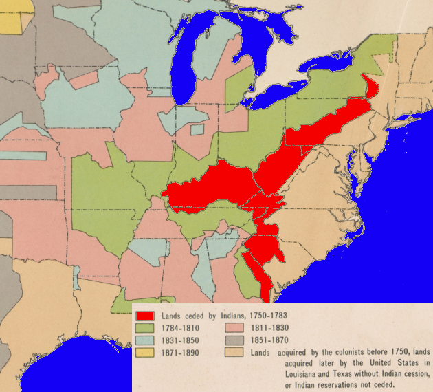
by the time of the American Revolution, colonial officials had negotiated treaties that supposedly extinguished Native American claims to almost all of Virginia south of the Ohio River
Source: Atlas of the Historical Geography of the United States, Indian Cessions, 1750-1890 (Plate 47a, digitized by University of Richmond)
Links
- American Indian Treaties Portal
- Chenocetah's Weblog
- Colonial Period Indian Land Cessions in the American Southeast
- Early Recognized Treaties With American Indian Nations, reprinted from O'Callaghan, E. B. (editor) Documents Relative to the Colonial History of the State of New York, vol. 6. Albany, NY, Weed, Parsons, and Co., 1855
- eHistory
- Indigenous Data Archive
- Library of Congress
- Mariner's Museum
- National Archives
- American Indian Treaties
- Ratified Indian Treaty 1: Five Nations - Fort George, New York, August 14, 1722
- Ratified Indian Treaty 3: Six Nations with Virginia and Maryland - Lancaster, PA (Printed Copy), June 1744
- Ratified Indian Treaty 4: Extracts from the Treaty with the Indians - Loggstown (Printed Copy), June 1, 1752
- Ratified Indian Treaty 7: Grant from Six Nations to King George III and Agreement of Boundary Line (Manuscript Copy) - Fort Stanwix, New York, November 5, 1768
- Ratified Indian Treaty 9: Six Nations - Fort Stanwix, October 22, 1784
- Ratified Indian Treaty 11: Cherokee - Hopewell, November 28, 1785
- Ratified Indian Treaty 18: Cherokee - Holston River, July 2, 1791, with Additional Article of February 17, 1792, at Philadelphia
- Ratified Indian Treaty 29: Cherokee - Near Tellico on Cherokee Ground, October 2, 1798
- Two Hundred Years of Native Relations
- National Humanities Center
- National Park Service
- Native Land
- Oklahoma State University
- Smithsonian Institution
- Southeastern Native American Documents, 1730-1842
- The Statutes at Large; Being a Collection of All the Laws of Virginia (by William Waller Hening)
- TNGenWeb Project
- Treaty of Middle Plantation
- Virginia Memory
- West of the Revolution: An Uncommon History of 1776 (by Claudio Saunt)
Location of Logstown (on French translation of Thomas Hutchins' "New map of the western part of Virginia, Pennsylvania, Maryland, and North Carolina," 1778)
Source: Library of Congress, Partie occidentale de la Virginie, Pensylvanie, Maryland, et Caroline Septle. la riviere d'Ohio, et toutes celles qui s'y jettent,
partie de la Riviere Mississippi, tout le cours de la riviere de Illinois, le Lac Erie, partie des Lacs Huron et Michigan &. toutes les contries qui bordent ces lacs et rivieres, par Hutchins, capitaine anglais
References
1. Ralph Hamor, "A true discourse of the present state of Virginia," 1614, republished by Virginia State Library, 1957, pp.12-14, https://archive.org/details/truediscourseofp1957hamo; "Chickahominy Tribe," Encyclopedia Virginia, Virginia Foundation for the Humanities, May 30, 2014. https://www.encyclopediavirginia.org/Chickahominy_Tribe (last checked August 28, 2017)
2. Alfred A. Cave, Lethal Encounters: Englishmen and Indians in Colonial Virginia, ABC-CLIO, 2011, p.129, p.131, https://books.google.com/books?id=teEOqdkXMVYC; Danielle Moretti-Langholtz, Angela L. Daniel, "A Seventeenth Century Chronology Drawn from Colonial Records with Contemporary Native Perspectives," Chapter 77 in A Study of Virginia Indians and Jamestown: The First Century, https://www.nps.gov/parkhistory/online_books/jame1/moretti-langholtz/chap7.htm; Helen C. Rountree, Pocahontas's People: The Powhatan Indians of Virginia Through Four Centuries, University of Oklahoma Press, 1990, pp.80-81, https://books.google.com/books/about/Pocahontas_s_People.html?id=fUzd7LeJpjYC (last checked August 28, 2017)
3. L. Scott Philyaw, Virginia's Western Visions: Political and Cultural Expansion on an Early American Frontier, University of Tennessee Press, 2004, p.4
4. Frederick W. Gleach, Powhatan's World and Colonial Virginia, University of Nebraska Press, 1997, pp.196-197; "Natives in the Landscape," Charles City County, 2006, http://www.charlescity.org/natives/topic-1677-80treaties.php; Spencer Tucker, James R. Arnold, Roberta Wiener, The Encyclopedia of North American Indian Wars, 1607-1890, ABC-CLIO, 2011, p.816, https://books.google.com/books?id=JsM4A0GSO34C (last checked December 15, 2015)
5. "Articles of Peace (1677)," Encyclopedia Virginia, http://www.encyclopediavirginia.org/Articles_of_Peace_1677,/a> (last checked April 23, 2015)
6. Francis Jennings, The Ambiguous Iroquois Empire: The Covenant Chain Confederation of Indian Tribes with English Colonies from Its Beginnings to the Lancaster Treaty of 1744, W. W. Norton & Company, 1984, pp.180-183, https://books.google.com/books?id=jfxdH5pslt4C (last checked May 30, 2015)
7. "Brent Town Site and Brent Town Grant," Virginia Historic Landmarks Commission Survey Form, File No. 76-163, 1981, http://eservice.pwcgov.org/library/digitallibrary/hsdw/B_Folder/BrentTownSite&Grant76-163/pdfs/BrentTownSite&Grant76-163SurvA.pdf (last checked November 7, 2015>
8. July 19, 1701 Deed or Nanfan Treaty, Iroquois Indians: A Documentary History, Newberry Library, http://www.sixnations.ca/LandsResources/NanFanTreaty.pdf (last checked June 22, 2016)
9. "Indian Land Cessions in the United States, 1784 to 1894," A Century of Lawmaking for a New Nation: U.S. Congressional Documents and Debates, 1774-1875, pp.552-554. http://memory.loc.gov/ammem/amlaw/lawhome.html; "Annual First Nations deer hunt at Short Hills," St. Catharines Standard, November 3, 2014, http://www.stcatharinesstandard.ca/2014/11/03/annual-first-nations-deer-hunt-at-short-hills; Six Nations (Haudenosaunee) & the Hadimand Tract: Beliefs vs. Facts blog, "False "Treaty Rights" Claimed by Six Nations - Developers and Others Take Note," January 18, 2014, http://deyoyonwatheh.blogspot.com/2014/01/false-treaty-rights-claimed-by-six.html; My Dundas Valley blog, "The Nanfan Treaty 1701 - Hoax of History," May 22, 2013, https://mydundasvalley.com/2013/05/22/the-nanfan-treaty-1701-hoax-of-history/; Francis Jennings, The Ambiguous Iroquois Empire: The Covenant Chain Confederation of Indian Tribes with English Colonies from Its Beginnings to the Lancaster Treaty of 1744, W. W. Norton & Company, 1984, p.212, https://books.google.com/books?id=jfxdH5pslt4C (last checked June 23, 2016)
10. "Conference between Governor Burnet and the Indian," part of The Great Treaty of 1722 Between the Five Nations, the Mahicans, and the Colonies of New York, Virginia, and Pennsylvania, C. J. Kappler, Indian Affairs: Laws and Treaties, vol. 2: Treaties, Government Printing Office, Washington, DC, 1904, p.659, http://earlytreaties.unl.edu/treaty.00001.html (last checked May 1, 2015)
11. "18FR72 Heater's Island 1699 - c. 1712," Diagnostic Artifacts in Maryland, Maryland Archaeological Conservation Laboratory, https://apps.jefpat.maryland.gov/diagnostic/SmallFinds/Site%20Summaries/18FR72HeatersIsland.htm (last checked May 15, 2024)
12. Helen C. Rountree (ed), Powhatan Foreign Relations, 1500-1722, University Press of Virginia, 1993, p. 195-196
13. "McDowell's Grave," Little Bits of History Along U.S. Roadways, November 18, 2011, http://littlebitsofhistory.blogspot.com/2011/11/marker-no_18.html; "Oh Shenandoah!," My McDowell History, http://leomcdowell.tripod.com/id32.htm (last checked July 31, 2015)
14. "Treaty of Lancaster," University of Nebraska-Lincoln, in "Envisaging the West: Thomas Jefferson and the Roots of Lewis and Clark," http://jeffersonswest.unl.edu/archive/view_doc.php?id=jef.00083; Early Recognized Treaties With American Indian Nations, "A TREATY, Held at the Town of Lancaster, in PENNSYLVANIA, By the HONOURABLE the Lieutenant-Governor of the PROVINCE, And the HONOURABLE the Commissioners for the PROVINCES OF VIRGINIA and MARYLAND, WITH THE INDIANS OF THE SIX NATIONS, In JUNE, 1744," http://earlytreaties.unl.edu/treaty.00003.html (last checked August 22, 2016)
15. Indian treaties printed by Benjamin Franklin, 1736-1762, Historical Society of Pennsylvania, 1938, p.104, https://archive.org/details/indiantreatiespr00vand (last checked August 25, 2015)
16. Timothy J. Shannon, Iroquois Diplomacy on the Early American Frontier,Penguin Books, 2008, pp.128-129
17. Timothy J. Shannon, Iroquois Diplomacy on the Early American Frontier,Penguin Books, 2008, pp.126-128; William R. Nester, The Great Frontier War: Britain, France, and the Imperial Struggle for North America, 1607-1755, Greenwood Publishing Group, 2000, p.31, https://books.google.com/books?id=7Mum6vMM5YwC (last checked December 24, 2015)
18. Michael N. McConnell, "Kuskusky Towns and Early Western Pennsylvania Indian History, 1748-1778," The Pennsylvania Magazine of History & Biography, Volume 66, Number 1 (January 1992), pp.38-47, http://journals.psu.edu/pmhb/issue/view/2540; Daniel K. Richter, James H. Merrell, "Beyond the Covenant Chain: The Iroquois and Their Neighbors in Indian North America, 1600-1800," Penn State Press, 2010, pp.103-104, https://books.google.com/books?id=ZQnEwUaPAegC; "The Treaty of Loggs Town, 1752," The Virginia Magazine of History and Biography, Volume 13 Number 2 (October, 1905), p.143, http://www.jstor.org/stable/4242735 (last checked December 23, 2015)
19. "Lords of Trade to Sir Danvers Osbourne," September 18, 1753, in John Romeyn Brodhead, Documents Relative to the Colonial History of the State of New York, procured in Holland, England and France, E. B. O'Callaghan (editor), Weed Parsons and Company, 1855, pp.800-801, https://books.google.com/books?id=BHjBclvt8GMC (last checked December 24, 2015)
20. "Albany Plan of Union, 1754," Office of the Historian, US Department of State, https://history.state.gov/milestones/1750-1775/albany-plan; "Albany Plan of Union 1754," Avalon Project, Yale Law School, http://avalon.law.yale.edu/18th_century/albany.asp (last checked December 24, 2015)
21. "Proceedings of the Albany Congress, 19 June 1754-11 July 1754," The Papers of Benjamin Franklin, vol. 5, July 1, 1753, through March 31, 1755, Leonard W. Labaree (editor), Yale University Press, 1962, pp. 344-353, posted at Founders Online, National Archives, http://founders.archives.gov/documents/Franklin/01-05-02-0096 (last checked December 24, 2015)
22. Anthony J. Hall, Gretchen Albers, "Easton Treaty," Historical Canada blog, July 30, 2014, http://www.thecanadianencyclopedia.ca/en/article/easton-treaty/; "Chapter Four: Pontiac's Rebellion," The French and Indian War in Pennsylvania, http://explorepahistory.com/story.php?storyId=1-9-6&chapter=4; "Treaty of Easton gives sides new hope for peace," Pittsburgh Tribune, October 19, 2008, http://triblive.com/x/pittsburghtrib/news/westmoreland/s_594105.html; David Waugaman, "The Great Easton Treaty of 1758: The 'Unknown' Turning Point of the French and Indian War," Masters Thesis, Wichita State University, 2015, p.50. p.54, pp.69-70, https://soar.wichita.edu/server/api/core/bitstreams/9b27b40e-f712-49d2-82b2-25ef85f37498/content (last checked November 4, 2025)
23. Francis Jennings, The Ambiguous Iroquois Empire: The Covenant Chain Confederation of Indian Tribes with English Colonies from Its Beginnings to the Lancaster Treaty of 1744, W. W. Norton & Company, 1984, p.16, https://books.google.com/books?id=jfxdH5pslt4C (last checked June 23, 2016)
24. "The Royal Proclamation - October 7, 1763," Avalon Project, Yale Law School, http://avalon.law.yale.edu/18th_century/proc1763.asp (last checked December 24, 2015)
25. David F. Hemmings, "Fort Niagara - 1759-1815," Niagara Historical Society and Museum, 2012, http://www.niagarahistorical.museum/media/02FortNiagara.pdf; "250th Anniversary of the Treaty of Niagara," Chiefs of Ontario, August 1, 2014, http://www.chiefs-of-ontario.org/node/920; "1764 Treaty of Fort Niagara Wampum Belts," Six Nations Legacy Consortium, July 15, 2014, http://www.chiefs-of-ontario.org/sites/default/files/files/Treaty_of_Fort_Niagara_Wampum_Belts.pdf (last checked August 3, 2015)
26. letter from Gov. Botetourt, "Instructions from Lord Botetourt to Col. Lewis and Dr. Walker," December 20, 1768, in "Virginia and the Cherokees, &c. The Treaties of 1768 and 1770," The Virginia Magazine of History and Biography, Volume 13 Number 1 (Jul7, 1905), p.28, http://www.jstor.org/stable/4242722 (last checked August 11, 2016)
27. "Journal of Doctor Thomas Walker - 1749-1750," West Virginia Archives and History, http://www.wvculture.org/history/settlement/loyalcompany02.html; Sam'l C. Williams, "Henderson And Company's Purchase Within The Limits Of Tennessee," Tennessee Historical Magazine, Volume 5 Number 1 (April, 1919), http://www.jstor.org/stable/42637407 (last checked August 11, 2016)
28. Robert Ewing Corlew, Stanley John Folmsbee, Enoch L. Mitchell, Tennessee: A Short History, University of Tennessee Press, 1990, p.39, https://books.google.com/books?id=9McNQm27VmUC; Paul H. Bergeron, Paths of the Past: Tennessee, 1770-1970, University of Tennessee Press, 1979, p.8, https://books.google.com/books?id=HETUSBu1Ey4C; Richard Douglas Spence, "John Donelson and the Opening of the Old Southwest," Tennessee Historical Quarterly, Volume 50 Number 3 (Fall 1991), p.26, https://www.jstor.org/stable/42626954; "George Washington to Botetourt, 5 October 1770," Founders Online, National Archives, https://founders.archives.gov/documents/Washington/02-08-02-0261 (last checked December 27, 2025)
29. Reuben Gold Thwaites, Louise Phelps Kellogg (editors), Documentary History of Dunmore's War, 1774, Wisconsin Historical Society, 1905, p.386, https://archive.org/details/documentaryhisto00kelluoft; Reuben Gold Thwaites, Louise Phelps Kellogg, Documentary History of Dunmore's War 1774, Wisconsin Historical Society, 1905, p.386, https://archive.org/details/documentaryhist00thwarich (last checked November 21, 2015)
30. C. Hale Sipe, The Indian Wars of Pennsylvania, The Telegraph Press (Harrisburg, Pennsylvania), 1931, pp.509-510, https://books.google.com/books?id=_kUIAwAAQBAJ (last checked November 21, 2015)
31. Archibald Henderson, "The Treaty of Long Island of Holston, July, 1777," The North Carolina Historical Review, Volume 8 Number 1 (January, 1931), p.57, http://www.jstor.org/stable/23516001; William R. Reynolds, Jr., The Cherokee Struggle to Maintain Identity in the 17th and 18th Centuries, McFarland, 2015, p.181, https://books.google.com/books?id=-QYyBgAAQBAJ (last checked July 6, 2017)
32. C. Hale Sipe, The Indian Wars of Pennsylvania, The Telegraph Press (Harrisburg, Pennsylvania), 1931, p.569, https://books.google.com/books?id=_kUIAwAAQBAJ; "Treaty With The Delawares, 1778," in Charles J. Kappler (editor), Indian Affairs: Laws and Treaties, http://digital.library.okstate.edu/kappler/vol2/treaties/del0003.htm (last checked November 21, 2015)
33. George William Van Cleve, We Do Not Have a Government: The Articles of Confederation and the Road to the Constitution, University of Chicago Press, 2017, p.143, https://books.google.com/books?id=NbbXAQAACAAJ (last checked April 25, 2018)
34. "Treaty and Land Transaction of 1784," Fort Stanwix National Monument, National Park Service, http://www.nps.gov/fost/learn/historyculture/treaty-landtransaction-1784.htm; Francis Jennings, The Ambiguous Iroquois Empire: The Covenant Chain Confederation of Indian Tribes with English Colonies from Its Beginnings to the Lancaster Treaty of 1744, W. W. Norton & Company, 1984, pp.16-17, https://books.google.com/books?id=jfxdH5pslt4C (last checked June 23, 2016)
35. Charles Elihu Slocum, History of the Maumee River Basin from the Earliest Account to Its Organization Into Counties, Bowen & Slocum, 1905, p.153, https://books.google.com/books?id=zRIwAAAAYAAJ; "Treaty of Fort McIntosh (1785)," Ohio History Central, http://www.ohiohistorycentral.org/w/Treaty_of_Fort_McIntosh_%281785%29; Dr. George W. Knepper, The Official Ohio Lands Book, The Ohio Auditor of State, 2002, pp.4-5, https://ohioauditor.gov/publications/OhioLandsBook.pd.; "Treaty of Fort McIntosh (1785)," Ohio History Central, http://www.ohiohistorycentral.org/w/Treaty_of_Fort_McIntosh_%281785%29 (last checked December 28, 2015)
36. Kevin T. Barksdale, The Lost State of Franklin, University Press of Kentucky, 2009, pp.102-103; "Colonial Period Indian Land Cessions in the American Southeast and Related Documents," http://www.tngenweb.org/cessions/colonial2.html#dumplin (last checked February 5, 2017)
37. Kevin T. Barksdale, The Lost State of Franklin, University Press of Kentucky, 2009, pp.105-106, https://www.google.com/books/edition/The_Lost_State_of_Franklin/i-cSEAAAQBAJ; "Treaty of Hopewell," Mississippi Encyclopedia, https://mississippiencyclopedia.org/entries/treaty-of-hopewell/ (last checked July 9, 2019)
38. Kevin T. Barksdale, The Lost State of Franklin, University Press of Kentucky, 2009, pp.109-110; https://www.google.com/books/edition/The_Lost_State_of_Franklin/i-cSEAAAQBAJ; Chuck Hamilton, "Cherokee treaties," https://www.academia.edu/42963262/Cherokee_treaties (last checked December 27, 2025)
39. "Wampum: Our Historical Record," Oneida Cultural Heritage Department, https://oneida-nsn.gov/wp-content/uploads/2016/04/WAMPUM-OUR-HISTORICAL-RECORD-9.13.pdf; Benjamin Franklin, "Remarks concerning the Savages of North America," "Franklin Papers," Founders Online, National Archives, https://founders.archives.gov/documents/Franklin/01-41-02-0280; "Wampum Belt," Plimoth Patuxet Museums, https://plimoth.org/yath/unit-2/wampum-belt (last checked March 1, 2025)
many Native American groups that once occupied lands claimed by Virginia were forced to moved west of the Mississippi River, particularly after passage of the Indian Removal Act of 1830
Source: Yale Collection of Western Americana, Beinecke Rare Book and Manuscript Library, Illustrations of the manners, customs, and condition of the North American Indians (artist: George Catlin)
"Indians" of Virginia - the Real First Families of Virginia
Exploring Land, Settling Frontiers
Virginia Places