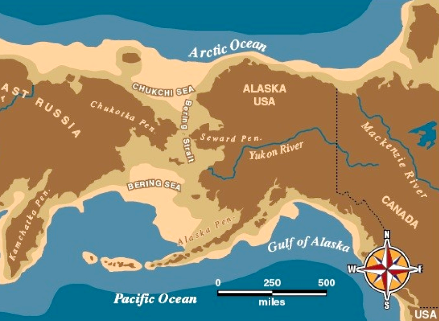
during the last Ice Age, what today is the water-filled Bering Strait was dry land
Source: National Park Service, History of the Bering Land Bridge Theory
The Vikings got to the North American continent much earlier than Columbus made it to the Caribbean islands in 1492, but both found the New World had already been settled by prior immigrants. The Spaniards called the people they discovered "Indians," but Columbus never made it to India.
The traditional theory is that Asians crossed to North America and evolved into the Native Americans discovered by Europeans in the 1400's. By that theory, the first humans to reach Virginia walked here. When they arrived, perhaps 15,000 years ago, Virginia's Coastal Plain extended 40 miles further east. The Chesapeake Bay had not formed yet.
Sea levels were 300-400 feet lower 20,000 years ago because so much water was trapped in glaciers. During the Ice Ages, the Bering Strait now separating Russia from Alaska was dry land. Asia was connected directly to North America by the Beringia land bridge.
during the last Ice Age, what today is the water-filled Bering Strait was dry land
Source: National Park Service, History of the Bering Land Bridge Theory
The Asians who crossed that Beringia land bridge did not have the East Coast of North America as a destination. Small hunting groups gradually moved to their east, as the ice melted and new hunting territory developed. As the Cordilleran Ice Sheet retreated, different bands of hunter-gatherers migrated into North America and then further south along the Pacific Coast shoreline. The humans took advantage of natural resources such as seafood and marine mammals, adding a successful new predator to the continent.
By 17,000 years ago, ice no longer blocked access to what today is called California. By 15,000 years ago, Native Americans were at the Topper Site in modern-day South Carolina.1
About 13,000 years ago, further melting of the Cordilleran Ice Sheet on the coast and the Laurentide Ice Sheet further inland created an ice-free gap further inland. Initially the opening gap between the two ice sheets was filled with water, but eventually bare soil was exposed. When there were enough growing plants to support large numbers of animals, that space between the two ice sheets became a suitable corridor for hunter-gatherer bands to travel from modern-day Alaska to Montana.2
By that theory, the ancestors of the first Virginians were Siberians. They were hikers carrying camping and hunting gear, wandering south and east until reaching the Atlantic Ocean. The Siberians may have walked south into what today is Mexico before discovering there was another coastline rich in seafood. Migrants could have started north and then east along the Gulf of Mexico before getting to Virginia. By that theory, the ancestors of the first Virginians came from Mexico, as well as Asia.
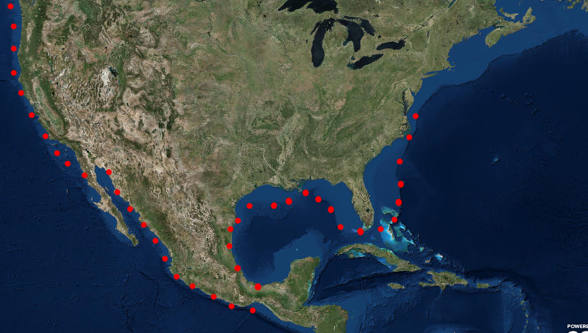
ancestors of the first Virginians may have followed the Pacific Ocean shoreline, then walked along the Gulf of Mexico and Atlantic Ocean shorelines when sea levels were 300 feet lower
Source: ESRI, ArcGIS Online
The first Virginians may have come via the western side of North America and then Mexico - but another theory is that the first Virginians came from France.
Just as migrants from Siberia could have taken advantage of the food resources on the Pacific Ocean coastline, other hunter-gatherers from Europe could have utilized the fish and marine mammals of the Atlantic Ocean shoreline.
The edge of the Atlantic Ocean ice provided a biologically-rich zone with blubber-rich marine mammals and fish. Paddlers in boats made from the skins of seals could have hunted along the edge, all the way to North America. Using boats was not a new technology. Humans had traveled across water to reach Australia 40,000 years ago, and the Paleocoastal peoples who settled on the West Coast 11,000-12,000 years ago paddled to the Channel Islands off the California coast.3
Settlement from Europe might explain how the Clovis points found in Virginia most closely resemble stone tools that were developed near Solutr� in southern France, rather than technology found in Siberian archeologic sites. Initial settlement from the east could also explain why Clovis points are more numerous in the Southeast. In addition, geological sources of the stone found in stockpiled caches with Clovis points suggest the population was migrating north and west, rather than from the Pacific Ocean to the east.4
Human occupation at the Cactus Hill site in Virginia could date back as much as 20,000 years ago. Migrants from Beringia could have bypassed the Cordilleran Ice Sheet early enough to be the ancestors of the Virginians who settled on a former channel of the Nottaway River - but if boating along ice packs was possible on the Pacific Ocean 20,000 years ago, then it was equally possible on the Atlantic Ocean.5
There are serious doubts about the 5,000-year gap between the dates of the Solutrean and Clovis cultures, the capacity for long distance boat travel at the end of the Ice Age, and the suitability of the edge of the icepack for migration. A solid edge to the icepack may have existed only briefly each year, and summer melting could have generated icebergs with boat-sinking waves at the same time ancient hunters were seeking seals.6
We know that global warming and global cooling have caused the shape of the continents to vary. The Atlantic Continental Shelf east of the Coastal Plain was exposed 18,000 years ago when the ice sheets covered Canada and parts of the United States south to Pennsylvania. When the glaciers and ice caps locked up vast amounts of water at the maximum extent of the Wisconsin glaciation, Virginia extended much further to the east.
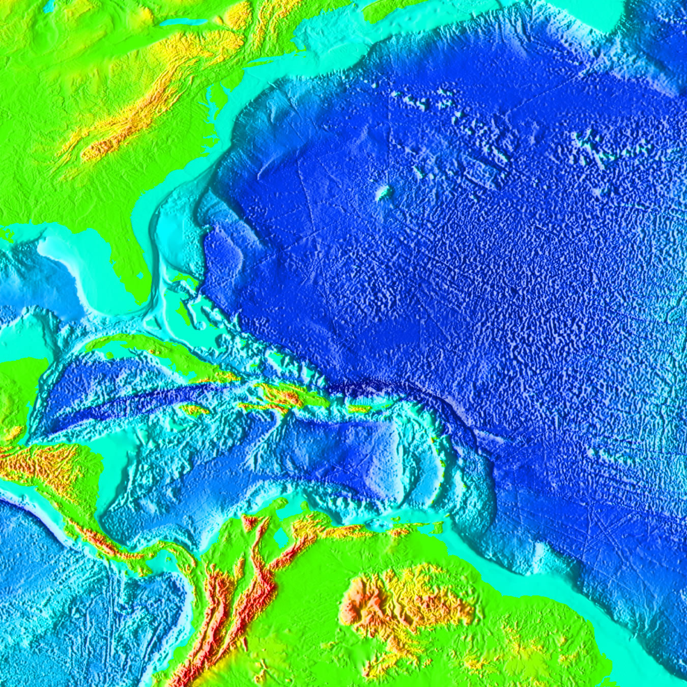
Atlantic Continental Shelf, on which the first Virginians may have hunted and camped
(look for light blue zone between the brown Blue Ridge, green Piedmont/Coastal Plain, and the dark blue deep ocean Abyssal Plain)
Source: NOAA
The first Native Americans in Virginia arrived before the Ice Age ended. As the ice slowly melted and sea levels rose, Virginia's Atlantic Ocean shoreline shifted to the west. In the Paleo and Archaic periods, foragers in Virginia had to cope with changing habitats and shorelines as climate shifted, river valleys on the Continental Shelf flooded, and the Chesapeake Bay formed.
Sea levels are still rising today. The land along Virginia's coast may also be sinking, due to geotectonic causes that are not fully understood. As a result, the Chesapeake Bay will expand and more of the Coastal Plain will gradually be covered with water. Barrier islands are migrating westward. If that pattern continues over the next few centuries, Tangier Island will be completely inundated and low-lying cities such as Norfolk will have to build massive flood walls... or people will have to migrate inland. If the Atlantic Ocean rises and "trangresses" onto the Coastal Plain, it won't be the first time that changing sea levels have altered settlement patterns in Virginia.
However and whenever they arrived, the Native Americans in Virginia were a low-tech culture compared to modern-day Virginians. If the Paleo-Indians walked to Virginia, then their ability to go further was blocked by the ocean - located then at the edge of the modern Atlantic Continental Shelf. If the first Virginians arrived in boats along the edge of the ice pack, the Solutrean hypothesis, then whatever capability those migrants had to navigate in the open ocean and fish/hunt offshore was lost.
The American Indians in Virginia got around the state for perhaps 15,000 years by walking. They created a network of paths, where they travelled regularly from their towns to good territories for hunting and fishing and gathering of wild foods. Paths also connected their towns, located near good drinking water and agricultural land - and the easy fords across the rivers.
Most likely, the first Virginians explored all the gaps for crossing over mountain ranges, and climbed all the mountain peaks. Even if later Europeans did not document the existence of marked Native American trails going to the tops of Virginia's mountain peaks, there were no "first ascents" in Virginia by anyone who arrived after 1607.
Technology for land transportation at the time of European contact had not improved in 15,000 years. The Native Americans who greeted the Jamestown settlers (or the Spanish who arrived 37 years earlier...) were still walking to get from Point A to Point B, on land. No Native American in Virginia used a wheel for transportation, or traveled on a horse, before the Europeans arrived.
Modern horses were introduced to North America by the Spanish and other Europeans who colonized the New World after 1492. There were no horses in Virginia between the time humans settled here and the Europeans brought horses. (Like starlings and honeybees, modern horses are a European species that reached America only after Columbus. The wild horses on the barrier islands - described to many young readers in Misty of Chincoteague - may have been survivors from Spanish shipwrecks in the 1500's, but are probably horses that escaped from (or were abandoned by) early English settlers.
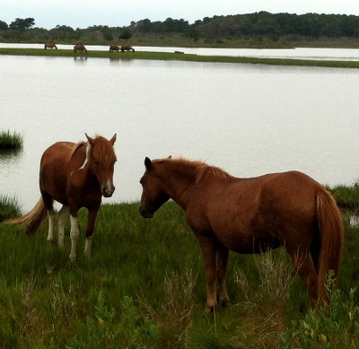
wild horses on Assateague Island - a species brought to North America by explorers and colonists starting in 1500's

Native Americans canoeing, as depicted on a 1600's Dutch map
Source: Library of Congress, Nicolaes Visscher, Novi Belgii Novaeque Anglia : nec non partis Virginia tabula multis in locis emendata
The Native Americans in Virginia never developed sailing ships, but they were using canoes routinely when the Europeans like John Cabot sailed along the North American shoreline at the end of the 15th Century. By 1607, Powhatan's power extended across the Chesapeake Bay to the tribes on the Eastern Shore.

Powhatan's capital was on the north bank of the York River at Werowocomoco, but he still controlled the Eastern Shore
Mpa Source: Color Landform Atlas of the United States)
It was physically possible to walk from "Powhatan's flu" northward, around the tip of the Chesapeake Bay to the Eastern Shore, and down to what the English labelled Cape Charles in 1607 - but Powhatan did not control much land north of the Rappahannock River.
To get from Werowocomoco to the Eastern Shore part of Tsenacommacah, Powhatan's people used canoes to cross the Chesapeake Bay. Paddling a canoe 20 miles, loaded with people and corn, may have been tiresome and risky when storms blew up on the bay, but it must have been a common activity in the early 1600's.
The Algonquians built those canoes with stone and bone tools, plus fire. Cutting a large standing tree with just fire and stone axes is possible theoretically, and would have allowed the Indians to select the most desirable tree trunks - but the investment in labor would have been immense.
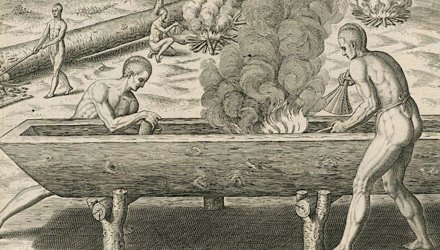
making canoes with stone and fire
Source: Google Arts and Culture, The Manner of Making Their Boats (by Theodore De Bry)
Whenever a Native American leader determined a fire should be set at the base of a tree standing on a shoreline in order to start construction of a new canoe, surely some of the workers assigned to the task must have murmured "there is a more reasonable way to find a suitable log for shaping into a canoe..."
On occasion, floods brought a supply of trees to the boatmakers. Already available, in-the-water flood debris could be sorted for tree trunks that could be shaped into a new canoe. The floods eliminated the hard work of cutting big trees in the forest with fire and stone/bone tools. However, dragging giant trunks up from a waterway onto dry land, for carving/burning into the shape of a canoe, would have required great effort.
Whenever a Native American leader determined that a tree trunk tangled in flood debris should be used to start construction of a new canoe, surely some of the workers assigned to the task must have murmured "there is a more reasonable way to find a suitable log for shaping into a canoe..."
Once a tree trunk was selected and burned/cut to the correct length, Native Americans used fire plus stone tools to make a canoe. Making a canoe in Virginia before the Spanish, French, Dutch, and English arrived would have required several weeks, and perhaps a month or more of work. Those boats were manufactured with Stone Age tools, until the Europeans arrived and brought iron and steel. The Powhatans made canoes from trees, burning and scraping away charred wood with sharp stones/shells until the trunk had been hollowed out.
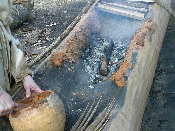
How do you burn a tree so it ends up as a canoe? Coals would be placed on the section of tree to be removed, charring the wood and making it easier to scrape away. But how did the canoe makers avoid burning sections of tree trunk that were not to be removed? Mud, good ol' Virginia mud. Mud was plastered on the edges of the trunk, ensuring that only the sections intended to be removed would burn. A thick layer would be slathered carefully on the edge of the tree trunk, and it would stop the fire from weakening the portion of wood that was being retained.
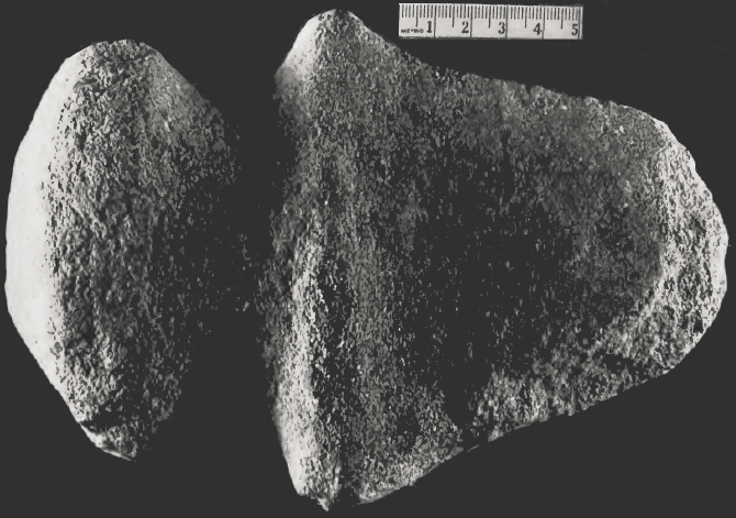
prehistoric stone ax, with a blade too dull to cut a tree without constant resharpening
Source: Smithsonian Institution, An Archeological Survey of Southwest Virginia (p.187)
Whether the Native Americans selected the best trunks from the intermittent flood logjams, or used a standing tree on land, there was a great deal of work required to convert tree trunks into canoes. In 1608, returning from his second exploration of the Chesapeake Bay, John Smith discovered that threats to destroy canoes (cutting them into "peeces") caused Nansemond warriors to capitulate to his demands for food:7
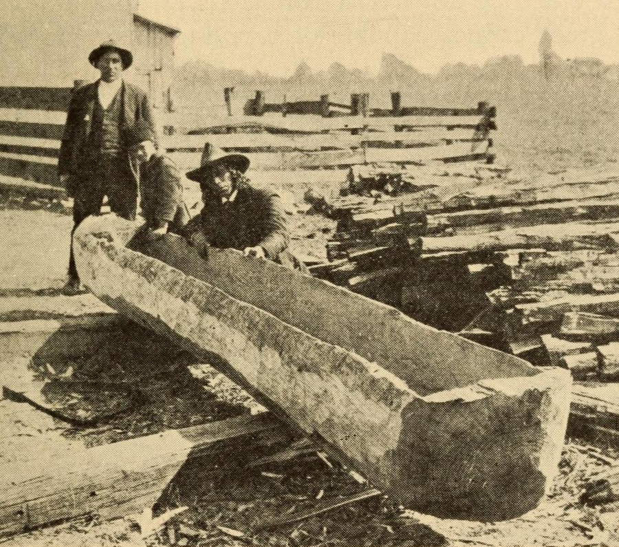
hand-carved canoe at Jamestown, made by burning the wood
in the center and scraping the charred wood with bone and stone tools
(protecting the edges with mud, so they did not burn)
Native Americans in Virginia never developed sailing technology, so they could not get across the Atlantic Ocean to "discover" Bermuda or Europe. The Eastern Shore was accessible by canoe, but Native Americans from Virginia reached points further east only when transported there in European sailing ships.
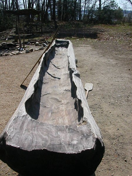
in the 1920's, ethnographer Frank Speck recorded how wooden canoes had been produced recently on the Pamunkey reservation
Source: Museum of the American Indian, Chapters on the ethnology of the Powhatan tribes of Virginia (p.375)
The first Virginians lacked access to horses until Spanish and English ships brought them to North America. There are iconic images painted in the 1800's of Native Americans hunting buffalo while riding horses, reflecting the quick adoption of horse culture on the Great Plains after Spanish mustangs began to reproduce widely west of the Mississippi River - but that sort of hunt never occurred in Virginia.
After arriving in Jamestown in 1607, English colonists displaced Algonquian-speaking and Siouan-speaking groups before horses became common in Virginia. The Susquehannock, Iroquois, Cherokee, Shawnee, and other groups traveled by foot when they crossed the Piedmont and the valleys west of the Blue Ridge to raid each other and colonial farms.
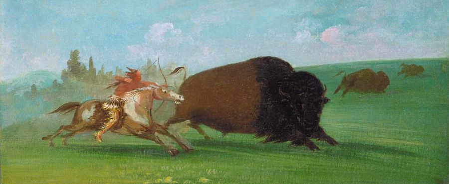
no Native American in Virginia used a horse to hunt a buffalo, unlike the Plains Indians on the Upper Missouri in the 1800's
Source: Smithsonian Institution, Buffalo Chase, a Single Death (by George Catlin)
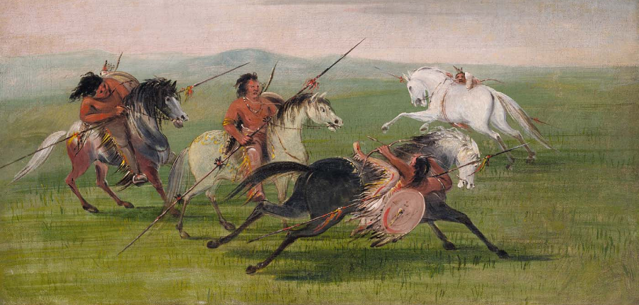
Native Americans in Virginia, unlike their counterparts on the Great Plains, did not take advantage of horses to hunt or defend lands against American settlement
Source: Smithsonian Institution, Comanche Feats of Horsemanship (by George Catlin)