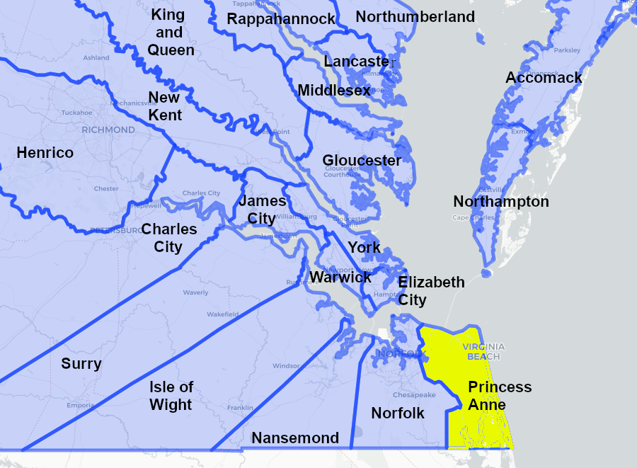
counties in Virginia near Princess Anne, when it was created in 1691
Source: Newberry Library, "Atlas of Historical County Boundaries
counties in Virginia near Princess Anne, when it was created in 1691
Source: Newberry Library, "Atlas of Historical County Boundaries
Princess Anne County existed between 1691 and 1963. It was created about a century after English colonists first sought to settle there.
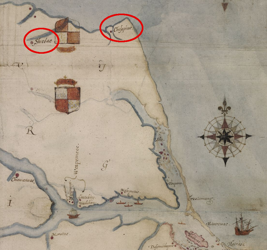
English colonists from Roanoke Island visited two major towns of the Chesapeake tribe in 1585-86
Source: British Museum, "La Virginea Pars," map of the E coast of N America from Chesapeake bay to Cape Lookout (John White, 1585-1593)
The English first arrived in 1585, long after the Spanish had explored the area. At the time, the land that became Princess Anne County was occupied by the Chesapeake tribe and they lived in three towns. Chesepioc (on the East Branch of the Lynnhaven River at modern Great Neck) and Skicoak (on the modern Elizabeth River) were enclosed by a wooden palisade. The third town, Apasus, was located at Lynnhaven inlet.
The territory of the Chesapeakes was the intended landing spot for the last expedition sent in 1587 by Sir Walter Ralegh. Despite instructions, the pilot dumped what became "the lost colony" back at Roanoke Island. The following winter, some of those colonists may have migrated north to the land of the Chesapeakes. If so, there is a chance that the English men were too difficult/assertive to incorporate into the tribe but the women and children (including Virginia Dare) might have survived. They would have become the first permanent European settlers in future Princess Anne County.
The next opportunity for English settlement was in 1607. The Susan Constant, Godspeed and Discovery stpped at Cape Henry. The English who went onshore for water and exploration quickly discovered that the Chesapeake were hostile. The Virginia Company had directed their first expedition to sail inland before establishing a settlement the Spanish could not attack easily, so they sailed past the sandy hills at the southern end of the Chesapeake Bay to built a palisaded town at Jamestown.
John Smith assigned some of the first English place names to places in Virginia, though at times he retained the Native American names. Mortons Baye on his map may be the location of modern Lynnhaven River.
Adam Thoroughgood, an early colonist who started as an indentured servant and became a leading businessman, is credited with giving Lynnhaven River its name. He had previously lived in Norfolk County (England) at King's Lynn. "Linn/lynn" was a term for a pool, cascade or waterfall, while "haven" referred to the mouth of a river or inlet that provided shelter for ships.1
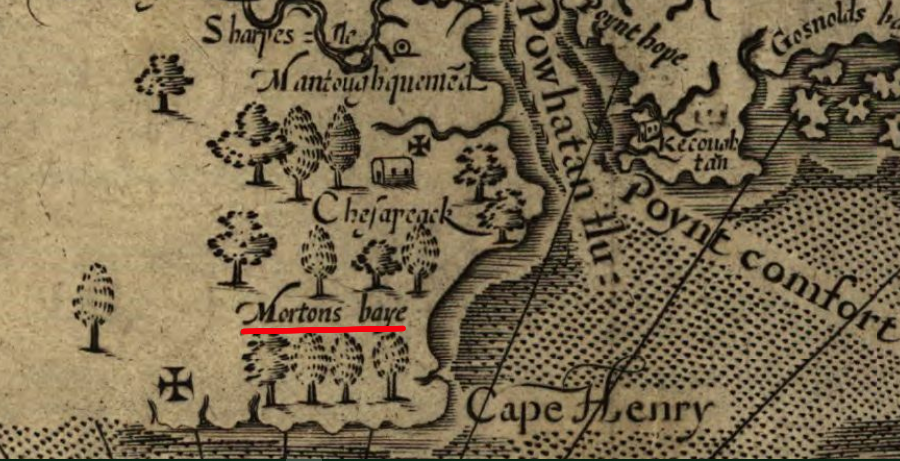
John Smith documented Mortons Baye, but Adam Thoroughgood named it the Lynnhaven River
Source: Library of Congress, Virginia (John Smith, 1624)
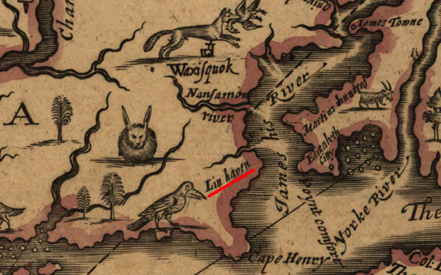
by 1651, Lynnhaven River had acquired its current name
Source: Library of Congress, A mapp of Virginia discovered to ye hills (John Farrer/John Overton, 1667)
In the 1600's, Cape Henry might have been isolated from the mainland by a series of streams and wetlands connecting Lynnhaven River to the Atlantic Ocean. Lynnhaven River's linkage to Broad Bay may have stretched further east past Linkhorn Bay, through Little Neck Creek via a now-gone stream called Stratton's Creek to a now-closed inlet connecting to the Atlantic Ocean.2
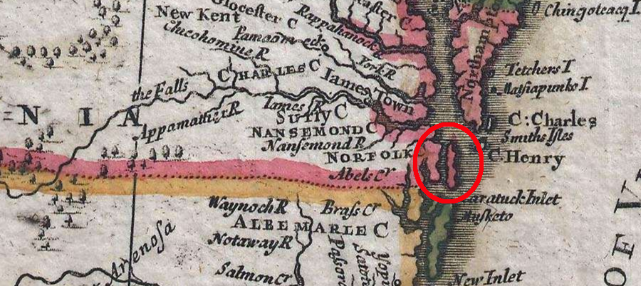
streams and wetlands in Princess Anne County caused mapmakers in the 1600's to show some of the oceanfront isolated from the mainland
Source: GeoGraphicus, A New Map of the English Empire in America viz Virginia... (Robert Morden, Christopher Browne, 1695)
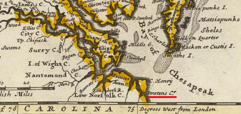
in the 1600's, Stratton's Creek might have connected the Atlantic Ocean with Lynnhaven River via an inlet to Little Neck Creek, then to Linkhorn Bay and Broad Bay
Source: David Rumsey Historical Map Collection, Virginia and Maryland (Augustine Herrman, 1736)
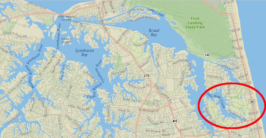
Little Neck Creek no longer connects to the Atlantic Ocean via an inlet
Source: ESRI, ArcGIS Online
The county started in 1691 when Lower Norfolk County was split to create Norfolk County and Princess Anne County. She was the younger daughter of King James II, and was born before he assumed the throne after his brother Charles II died. Charles II required that Anne and her older sister Mary be raised as Protestants, though their father was a Catholic.
James II had a male heir with his second wife, but only the two daughters became queens. James II was displaced from the throne in the bloodless "Glorious Revolution" of 1688. His older daughter Mary and her husband William were invited by English leaders to "invade" England. William and Mary ruled as a couple, during which time the College of William and Mary was established. After Mary died in 1694, and then William in 1702, Anne assumed the throne and ruled until her death in 1714.
All three of the children of William and Mary were stillborn. As a result, Anne was next in line of succession when Princess Anne County was created, so long as James II male heir was successfully excluded because he was a Catholic. If she had supported her father's efforts to retain his throne, she would have been forced into exile with James II and the Virginia General Assembly would have named the new county after someone else.
James Edward, known as the "Old Pretender," failed in his effort to seize power after Queen Anne died. The Jacobite Rebellion of 1715 sought to keep a member of the Stuart dynasty on the English throne, but Queen Anne was replaced by a member of the House of Hanover who became King George I. The son of the Pretender, the grandson of James II, tried again 30 years later. "Bonnie Prince Charlie" led a small rebellion in Scotland in 1745, but it failed and he never became Charles III.3
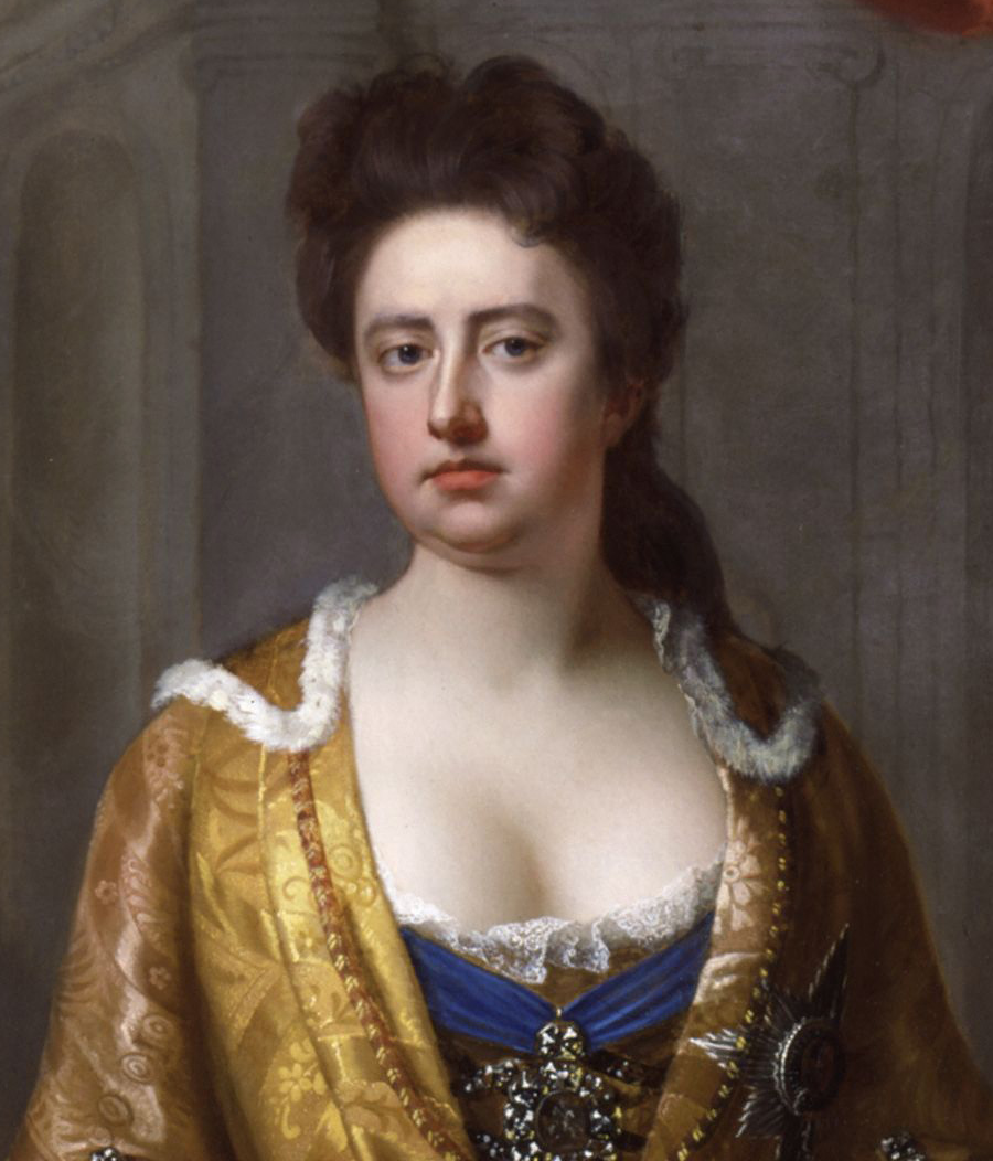
Princess Anne became Queen Anne in 1702 and ruled until her death in 1707
Source: Wikipedia, Anne, Queen of Great Britain
In 1691, after 22 years without creating a new county, the General Assembly created counties named after the new rulers. The county named King and Queen honored William and Mary, while Princess Anne honored Queen Mary's younger sister. Princess Anne ended up being remembered in Virginia with the names of four rivers (Rivanna, Rapidan, North Anna, South Anna) and two counties (Princess Anne and Fluvanna). The upper James River was also called the Fluvanna River for years.
Settlement in Lower Norfolk County had expanded until there was a need for a new county government. George Kemp had patented land at the eastern end of the Elizabeth River's Eastern Branch in 1652, and it had grown into Kempe's Landing when Princess Anne County was created. The town of Kempsville was incorporated at the end of the American Revolution in 1783, and served as the county seat from 1778-1823. Designation of Kempsville as a town ended in 1963 when it became part of the City of Virginia Beach.
There were five different sites for the Prince Anne courthouse in the county's history. The last county seat was established eight miles southeast to be more centrally located geographically, though the new location had no concentration of people. The community of Princess Anne gradually developed around the new courthouse, and s still the site of the Virginia Beach municipal center.
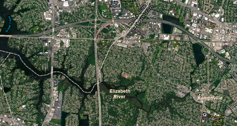
Kemps Landing, at the eastern end of the Elizabeth River's Eastern Branch, today
Source: ESRI, ArcGIS Online
The Town of Virginia Beach was organized in 1906. In 1952, after the population growh of World War II, the town became an independent city separate from Princess Anne County. The existence of Princess Anne County ended in 1963 when it merged with the city of Virginia Beach.4
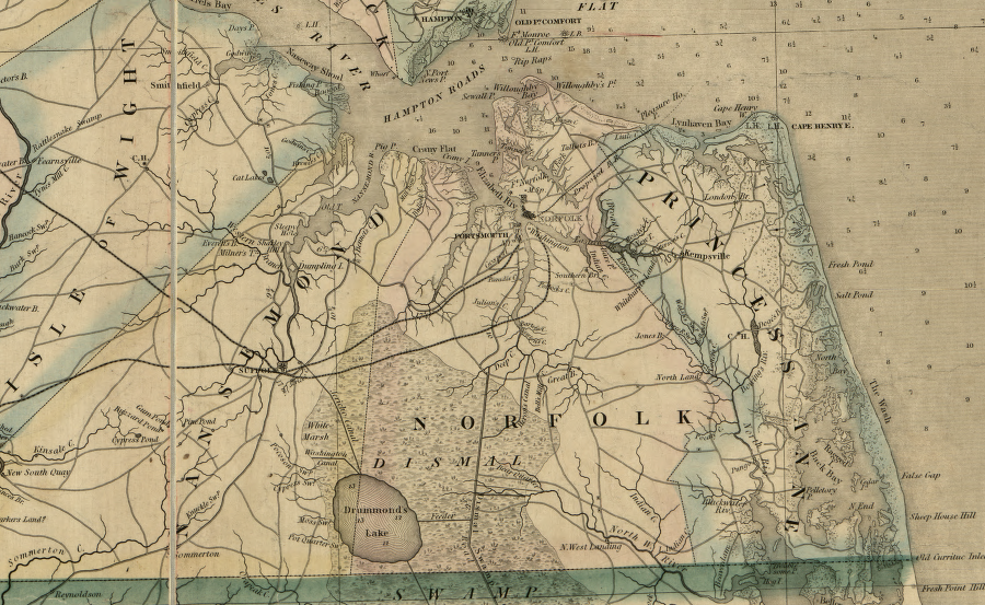
the counties of Princess Anne, Norfolk, and Nansemond are now parts of the cities of Virginia Beach, Chesapeake, and Suffolk
Source: Library of Congress, A map of the state of Virginia, constructed in conformity to law from the late surveys authorized by the legislature and other original and authentic documents (1859)
In 1962, Virginia Beach was a small city encompassing the resort area along the Atlantic Ocean shoreline, at the end of the railroad line. The baby boom after World War II and military jobs associated with the Cold War dramatically spurred real estate development in Hampton Roads.
Princess Anne County was at risk of losing land and population to the City of Norfolk through the annexation process. Norfolk could expand its boundaries by annexing land from an adjacent county, but could not annex from a city. Transforming from Princess Anne County into the City of Virginia Beach blocked any hopes of Norfolk to expand eastward.5
Voters in Princess Anne County and the City of Virginia Beach agreed to consolidate on January 4, 1962. That step that occurred formally on January 1, 1963, bringing an end to the local government known as Princess Anne County. The county office at Kempsville became a city hall.6
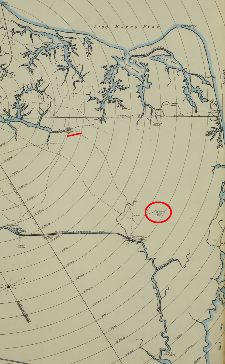
the courthouse for Princess Anne County was moved from Kempsville to a more-central location in the agricultural county
Source: Library of Congress, Sanborn Fire Insurance Map from Norfolk, Independent Cities, Virginia (Sanborn Map Company, 1887)
at the start of the American Revolution, there was little settlement along the Atlantic Ocean shoreline
Source: University of Michigan, William L. Clements Library, Part of the modern counties of Princess Anne, Norfolk, and Nansemond, Virginia
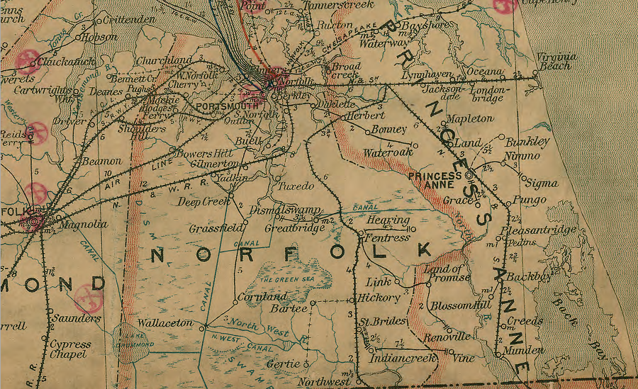
the railroad network of Princess Anne County in 1906
Source: Library of Congress, Post route map of the states of Virginia and West Virginia (Postmaster General, 1906)