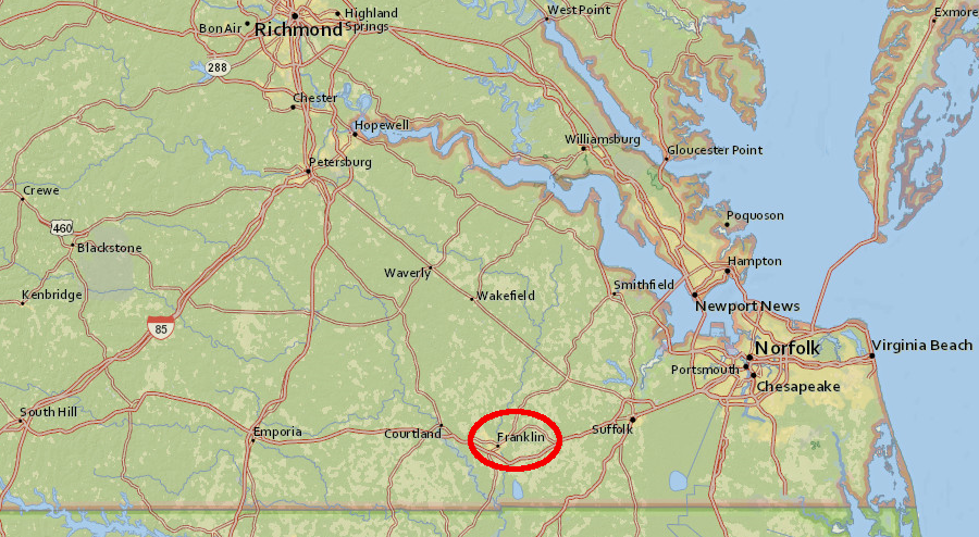
the City of Franklin is near the North Carolina border (a separate jurisdiction, Franklin County, is in the Blue Ridge)
Source: ESRI, ArcGIS Online
the City of Franklin is near the North Carolina border (a separate jurisdiction, Franklin County, is in the Blue Ridge)
Source: ESRI, ArcGIS Online
Residents of Franklin, Virginia got a clear lesson in watershed dynamics in September, 1999.
Hurricane Floyd dropped just as much rain on Williamsburg as it did on Franklin. In both cities, rainwater drained into nearby creeks and into the soil. By Saturday, September 18 - two days after the hurricane had passed - Williamsburg was dry and almost fully recovered from the storm. Franklin, however was under 12 feet of water in some places.1
Why?
Williamsburg was built in 1699 on the divide between the York and the James rivers. It is at the top of the "roof ridgeline." After a rainfall, water drains away from the city, leaving Williamsburg high and dry. Colonial roads that evolved into modern Route 60, connecting Hampton with Richmond, were located on the watershed divide to minimize muddy, soggy spots that would slow down a wagon or horse.
Franklin is located on the banks of the Blackwater River, downstream of most of the Blackwater watershed. The 17 inches of rain that fell on fields and forests in Surry, Southhampton, and Isle of Wight counties during Hurricane Floyd flowed into local creeks. The water in those creeks flowed downhill, and when it reached Franklin two days later the city was drowned by the runoff.
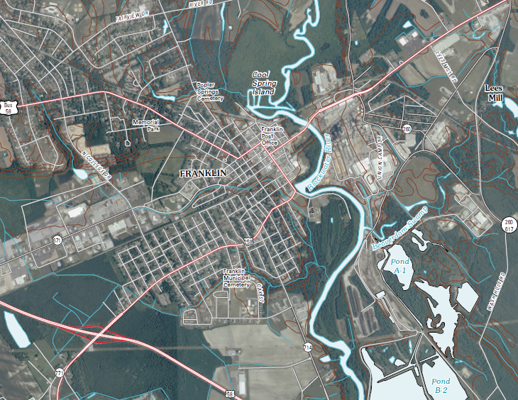
Blackwater River flows through the City of Franklin, before merging with Nottoway River to form the Chowan River at the North Carolina border
Source: US Geological Survey, franklin 1:24,000 scale topographic map (2010)
We all live downstream of some pollution source. Do you want:
Then you need to consider what's upstream. The waters in Chesapeake Bay come from New York, Pennsylvania, West Virginia, District of Columbia, Delaware, and Maryland as well as Virginia. If we want to "Save the Bay" we'll need political partnerships with those states, perhaps mediated through the Federal government.
Assume a tanker truck filled with diesel fuel is headed south down Route 123 from Fairfax City to Occoquan. In an August thunderstorm, the driver hits another car in the intersection at the University Drive stoplight near the Field House. The trucks falls on its side, gashing a tear in the side of the tank and spilling the contents. Where will the diesel fuel go?
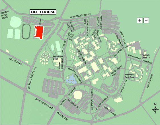
Source: GMU Campus Map (before the latest buildings were added...)
If the spill occurred on the west side of Route 123 in Fairfax County, on the side where GMU has a Field House and ballfields, the rain will carry the diesel downhill into Popes Head Creek. The poisoned water will flow through Clifton and into Bull Run, just upstream of the Hemlock Overlook Center for Outdoor Education and the Bull Run Marina. The water will end up in Occoquan Reservoir, which supplies drinking water to much of Fairfax County. The Fairfax County Water Authority will want to be notified quickly if their water supply - the Occoquan Reservoir - might be contaminated.
On the other hand, if the truck spilled diesel fuel towards the east side of Route 123, the poisoned water would flow downstream (hey, gravity is the same on both sides of the road...) to the pond in front of the Center for the Arts Building. In that case, the water will keep flowing into Rabbit Run, and ultimately into Pohick Creek and then into the Potomac River near Gunston Hall where George Mason lived. In that case, the slug of pollution will flow down the Potomac River - but the drinking water for Fairfax County would not be at risk. (The intake pipe for the Grifith water treatment plant is behind the dam at Occoquan, uphill and safely isolated from any pollution in the Potomac River.)
In either scenario, the fish in Bull Run or Pohick Creek would live or die based on the direction the water flows. The fish in the Potomac River would be affected too, if enough diesel fuel spilled so the slug of pollution reached the river. There's an old saying - dilution is the solution to pollution... but don't tell that to the fish in the stream next to the spill.
In Smyth County, the town of Saltville was devastated in 1972 by the closure of its main industry, the Mathiessen chemical plant. Mathiessen was there because of the salt, pumped as a brine from underground. After extracting the chlorine, the wastewater was dumped from that plant into the North Fork of the Holston River. It was so full of sodium that the state of Tennessee complained about the cost of treating the Holston River water to make it suitable for Knoxville's drinking water.
Virginia's State Water Control Board set limits on water quality in 1967, and the company then closed the plant rather than invest in an upgrade to the old facility. Later, mercury was discovered and the area became a Superfund site. Today you can't eat the fish you catch in the North Fork of the Holston River.2
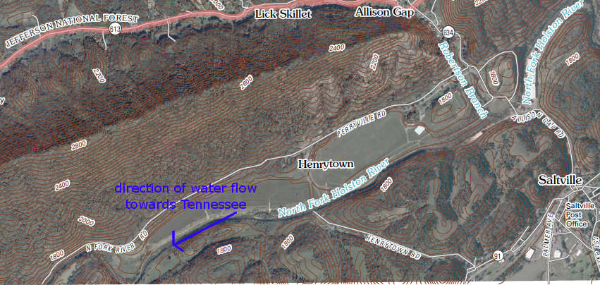
Saltville is in watershed of North Folk, Holston River
Source: US Geological Survey (USGS), Saltville 1:24,000 scale topographic map
Everyone living downstream should care about the quality of sewage treatment plants and septic systems upstream. The city of Richmond gets its drinking water from the James River. Utility officials (and anyone who drinks water from the municipal water system) pay attention to how well Westvaco and Georgia Pacific paper mills, cities such as Lynchburg and Charlottesville, and other "point sources" upstream of Richmond treat their wastewater before dumping it into the river. Even agricultural areas contribute farm runoff; cows in the watershed don't wear diapers.

Richmond's drinking water may have cycled earlier through factories, power plants, or animal/human intestines in the watershed upstream
Source: National Weather Service - Middle Atlantic River Forecast Center, James River below Holcomb Rock
On the Eastern Shore, the concentrated manure from poultry farms has impacted water quality. There has been opposition to opening new combined animal feed operations ("factory farms") in Southside Virginia. That area is working very hard to attract new jobs after textile operations have closed, based on recognition that concentrated manure can pollute local drinking supplies and fishing sites. Obviously, people care about watersheds because what goes into the river upstream affects what you can do with the water downstream.
Caring about what goes into the river is a two way street - what happens downstream can affect humans who live upstream. Kepone, a chemical poison that causes nerve damage, was dumped illegally in Hopewell, so fishing was banned for years in the lower James River. This reduced the recreational opportunities for Virginians throughout southeastern Virginia, including Richmonders who lived upstream. Even today, it affects proposals to dredge a deeper channel in the James so larger ships can dock at Richmond's Deepwater Terminal.
Water does not flow uphill... but fish and eels swim upstream from the Atlantic Ocean, through the Fall Line, to points west in the Piedmont physiographic province. If the fish or eels absorb contamination in the Atlantic Ocean or the Chesapeake Bay, they will already be contaminated when they swim upstream past Richmond.
West of Richmond, water is diverted into the old James River and Kanawha Canal to feed the Richmond water treatment plant near Byrd Park. The city supported construction of a $1.5 million fishing ladder at Boshers Dam to help anadromous American shad reach spawning habitat, all along the James River up to Lynchburg. The state estimates communities upstream of Richmond will receive a large part of the $5-7 million in economic benefits resulting from increased shad fishing opportunities - another way that keeping contaminates out of downstream waters will enhance recreation opportunities of upstream residents.
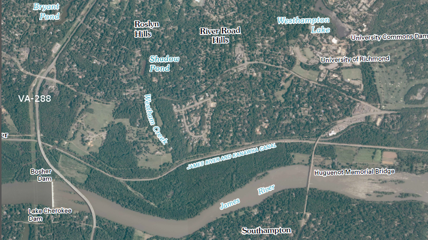
Boshers Dam, upstream from Huguenot Bridge and VA-288 west of Richmond
Source: US Geological Survey (USGS), Richmond 1:24,000 scale topographic map (2010)
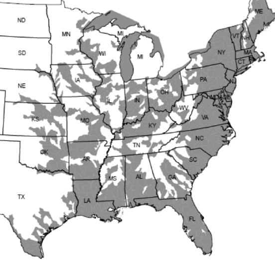
American eels can carry pollutants from the Atlantic Ocean far upstream to areas shaded in gray
Source: US Fish and Wildlife Service, American Eel (Anguilla rostrata) 12-month Petition Finding Form (Figure 2)