
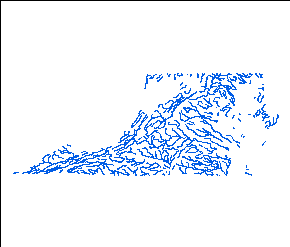
major rivers and lakes in Virginia
Source: US Geological Survey (USGS), Reference and Outline Maps of the United States - Rivers and Lakes
major rivers and lakes in Virginia
Source: US Geological Survey (USGS), Reference and Outline Maps of the United States - Rivers and Lakes
The two fundamental components of water droplets in Virginia are very old, though the hydrogen and oxygen atoms in specific H2O molecules may have combined together just moments ago. Most of the hydrogen atoms formed soon after the Big Bang 13.8 billion years ago, though some were created later by radioactive decay. The oxygen atoms were created later by fusion within stars, and most of them are over 4.5 billion years old.
Our particular solar system formed 4.5 billion years ago as celestial particles coalesced, probably as a result of a burst of gravity created by a nearby supernova. As gravity brought more particles together, the temperature in the center rose past 280℉ and a protostar formed.
Hydrogen atoms collected on dust particles. When they combined with oxygen atoms, H2O ice molecules formed. Near the protostar ice warmed and sublimated into water vapor. Those gas molecules which drifted away from the center of the protoplanetary disk, beyond the "ice line" where temperatures were colder, became solid ice again.
According to various planet formation theories, it took 50-100 million years for the particles circling the sun to form larger and larger clumps which eventually consolidated to create the planets. The presence of water on Earth is problematic, since the energy of various collisions would have dispersed the light water molecules back into space. To get water on the final assemblage of Earth 100 million years after the sun formed, two wet protoplanets may have collided or icy comets may have brought water molecules after Earth had formed as a rocky, dry planet.
Planets further from the sun, today's icy planets circling the sun beyond the "ice line," probably consolidated before the rocky planets closer to the sun. Jupiter and Saturn may have been the very first, becoming planets within just a few million years as particles circling the sun in the protoplanetary disk accumulated together. The next planets were Uranus and Neptune.
A popular theory is that Jupiter and Saturn migrated towards the Sun, then through gravitational interaction "tacked" back to their current orbits. Netptune migrated outward, moving far enough away from the sun to pass Uranus. In that migration, Jupiter swept up much of the material in Mars' current orbit; that would explain why Mars has only 10% of the mass of Earth.
The migration of the gas giants into their current orbits could have displaced icy planetesimals from their orbits. Some were flung outward into the Kuiper Belt, including dwarf planets such as Pluto. Other planetesimals were shoved by the changing patterns of gravity towards the Sun. Those that collided with the Earth contributed water to a once-dry planet.

Earth may have formed as a dry planet from a protoplanetary disc 100 million years after the sun
Source: Webb Space Telescope, Protoplanetary Disks (ALMA, VLT, Hubble)

water on Earth may have been provided by collisions with ice-rich comets
Source: NASA Universe, It's Raining Comets
An alternative theory suggests that the planets assembled much faster. The celestial dust particles not incorporated into the sun were consolidated by gravity into millimeter-sized pebbles covered in tiny ice particles. Those pebbles then combined with each other over 5 million years into planets. The pebbles did not go through a phase of forming large chunks, which later collided in major events to form the planets. If that theory is correct, in other solar systems with planets at the equivalent distance from the sun as Earth, those planets should also be rich in liquid water.
Perhaps just 1% of the water molecules on Earth have survived intact over the last 4.5 billion years and date back to near the origin of the Solar System. The other water molecules present today formed from hydrogen and oxygen atoms which may have been incorporated in different minerals over time.1
The oldest water discovered on Earth was found at Kidd Creek Mine in Ontario, Canada, 1.5 miles underground in the deepest mine in the world for extracting metal ore. The water was trapped in the rock 1.6 billion years ago, a date determined by measuring the radioactive decay products of noble gases (neon, argon, and xenon) found in the water samples. It has been isolated from the surface despite tectonic rearrangement of the bedrock, and today is located on top of the 2.7 billion year old Precambrian Canadian Shield.
That ancient water is about 10 times more saline than seawater. It is rich in dissolved sulfates, similar to what is extruded at hydrothermal vents on the seafloor. The ancient water also included ancient life. Scientists found chemolithotrophic microbes living on chemical reactions between hydrogen and sulfate, with no dependency upon photosynthesis, within the water.2
Water is key to the topography of Virginia, as well as to its lifeforms. Virginia's surface has been shaped by its rivers. Storms have carved away at the land since the continents and the atmosphere emerged, and the rivers have carried "Virginia" mountains to the oceans before the current mountains (or oceans) even existed.
The topography that we see today is a brief snapshot in geologic time. In another 50 million years old mountains will be flattened by erosion, new mountains will be uplifted by tectonic forces, and rivers will move their channels as the perpetual process of erosion continues to reshape the landscape.
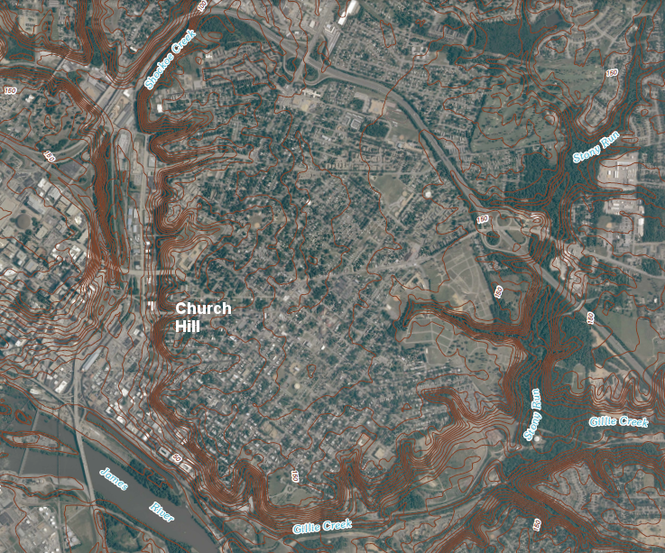
Church Hill in Richmond, site of Patrick Henry's Give Me Liberty or Give Me Death speech at St. John's Church on March 23, 1775, is on the high ground (watershed divide) between Shockoe Creek and Stony Run/Gillie Creek
Source: US Geological Survey (USGS), Richmond 1:24,000 scale topographic map (2010)
Today the Blue Ridge and Allegheny Front are the primary topographic features directing water towards the east or west. The Eastern Continental Divide separates the Atlantic Ocean watershed from the Gulf of Mexico watershed.
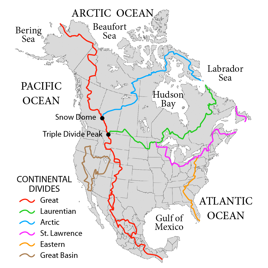
the Eastern Continental Divide is one of multiple watershed divides in North America
Source: Wikipedia, Eastern Continental Divide
Virginia's rivers have been carrying sediments downstream, reshaping the surface of the state, for eons. The New River was flowing even before the continents smashed into each other 300 million years ago, before "thundering lizards" left their dinosaur tracks in the sandstones of Triassic Basins. The fastest flowing rivers and the waterfalls are concentrated in the mountains where there is topographic relief. On the Coastal Plain, rivers flow sluggishly until they reach sea level, where the direction of flow is reversed at high and low tides
Most Virginia rivers were redirected by the Appalachian Orogeny, 300 million years ago, and subsequent creation of the Atlantic Ocean. The New River is unusual because it continued to flow through its old channel, and cut through much of the Appalachian Mountains as they rose. The current New River Gorge in West Virginia is just the most recent demonstration of how the energy in the New River's falling water can defeat the strength of rising rock.
Based on the assumption that the river's channel through the Blue Ridge and Appalachian Plateau has not changed much the Alleghenian Orogeny, the New River is often called the second oldest river in the world after the Nile, though that claim may be overstated.3
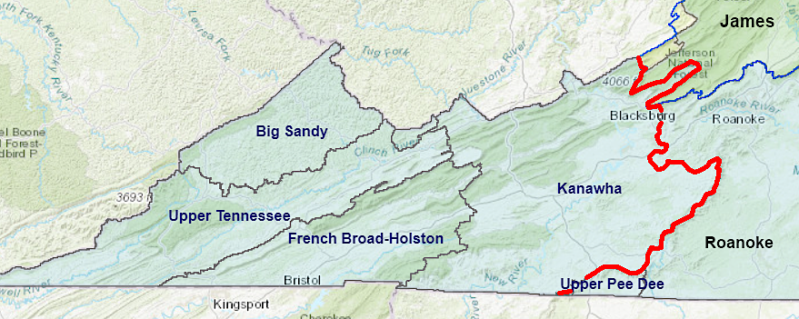
the New River flows west to join the Kanawha River and ultimately the Mississippi River, while the James and Roanoke rivers flow east to the Atlantic Ocean
Source: Northern Virginia Regional Commission (NVRC), Virginia Watersheds Interactive Map
Today:4
 A map of the hydrography of Virginia shows the rivers run in different directions. They do not all flow south, or "down the map." Rain falling in Southwest Virginia ends up flowing though Tennessee, Kentucky, and West Virginia to the Ohio River, then down the Mississippi River to New Orleans and the Gulf of Mexico.
When the clouds move just a little further to the north or east, the rainfall will run downhill in the other direction. It can follow the Roanoke River watershed to Albemarle/Pamlico Sound, or the James River/Potomac River watersheds to the Chesapeake Bay.
When it quits raining, streams do not dry up immediately. Water in the ground seeps into the drainages. Sometimes the water emerges in a defined location called a spring; sometimes to seeps in less obvious ways into streams and rivers.
A river will run even during a drought, as groundwater from previous rains seeps through the soil to the low spots. In a drought, those groundwater levels will gradually drop, just as a wet sponge left out in the sun will gradually dry from the top to the bottom.
When the groundwater level drops below the level of the stream, then the bed of the stream - the sand, mud, or rocks in the bottom - will be exposed. In the summertime, many areas have edges of their streambeds showing rounded rocks and, occasionally, flopping fish in remaining pools of water. The rocks had rough edges when they first reached the earth's surface through erosion, but got rounded edges as the rocks were bounced around and washed downstream.
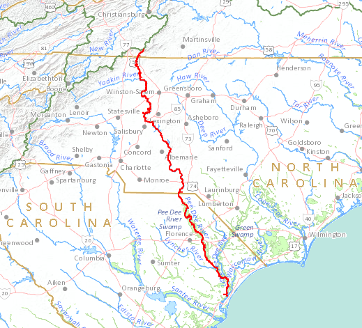
a raindrop falling into the headwaters of the Ararat River in Virginia will flow 376 miles to the mouth of the Pee Dee River in South Carolina
Source: US Geological Survey (USGS), National Atlas Streamer
It's the natural cycle for rivers to etch the landscape, until ultimately (if left unaffected by other forces) the mountains are transformed into hills and then into a flat level plain. In the continental collisions before the Appalachian orogeny, 25,000-feet high mountains were located where Emporia and Richmond are located today. In the last 300 million years, Virginia's rivers have eroded those mountains away. Today you can see the incredible sediments carried westward, in the layers of sandstone and shale stretching from western Virginia through West Virginia to the Great Lakes.
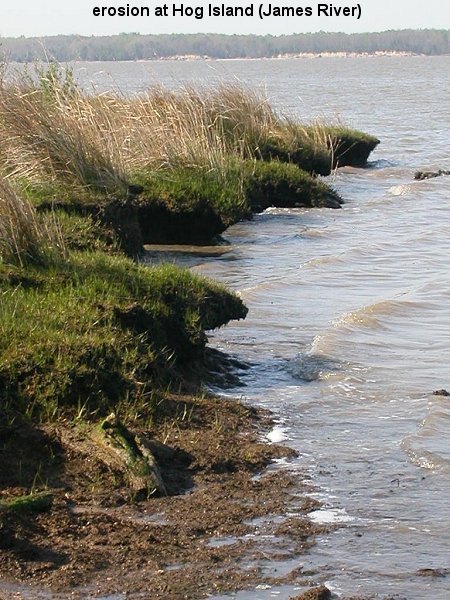
shorelines erode and paths of rivers change over time
Thousands of feet of sediments eroded westward off the mountain ranges pushed up by the Taconic and Acadian orogenies, filling the lowlands in the center of the continent and forming today's Ohio, Indiana, and Illinois. Perhaps an equal amount eroded to the east, prior to the creation of the Atlantic Ocean. After the continents split again and the Atlantic was formed, the sediments on the Coastal plain and the Coastal Shelf were deposited primarily by the Potomac, Rappahannock, York, and James rivers (as they are known today, in their current locations).
Much of the largest estuary in the Western Hemisphere is located in Virginia. The Chesapeake Bay is the drowned mouth of the Susquehanna and James rivers. Both rivers once ran separately to the Atlantic Ocean, before sea level rose after the last glacial period and formed the modern bay about 3,000 years ago. You can still see evidence of the separate river channels at the mouth of the bay.
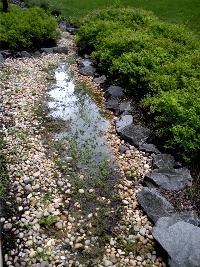
artificial stream to drain stormwater behind Research 1 building on Fairfax Campus of GMU
When the Chesapeake Bay Bridge-Tunnel was built, the U.S. Navy required a portion of the span be constructed as an underwater tunnel. This was intended to prevent an enemy from collapsing the bridge, blocking the shipping channels, and trapping the aircraft carriers at Norfolk. There are two tunnels now - the southern one in the deep channel that was carved by the ancestral James River, and the northern tunnel in the channel of the old Susquehanna River.
The southeast portion of modern Virginia is known today as both Hampton Roads and as Tidewater, but Tidewater is also applied to all portions of Virginia where the water level is affected by the tides - which is most of the land east of I-95 and north of US 460. Tidewater is not necessarily saltwater. Alexandria, Fredericksburg, and Richmond are tidewater ports. After a heavy rain upstream, the water in those ports may be completely fresh, with no brackish/salt water at the surface, but the tides will still cause the fresh water to rise and fall at the docks.
Virginia requires separate fishing licenses for saltwater and freshwater, and separate agencies enforce regulations. Back Bay, Northwest River, North Landing River, Dismal Swamp Canal south of Deep Creek Locks, and the Intercoastal Waterway upstream to Great Bridge Locks are defined as "freshwater." The boundary between salt/fresh is defined as:5
| River | Line |
|---|---|
| Potomac River | Rt. 301 Bridge |
| Rappahannock River | Rt. 360 Bridge |
| Piankatank River/Dragon Run | The 1st set of power lines immediately upriver of Anderson Point |
| York River System (including the Mattaponi and Pamunkey Rivers) | Rt. 33 Bridges |
| James River | A line connecting Hog Point on Hog Island (Surry County) and the downstream point of the mouth of College Creek (James City County). |
Differential erosion has carved the topography of Virginia. Water has dissolved and carried away softer rock formations faster than harder bedrock for the last 250 million years, since the collision of tectonic plates uplifted land in the Alleghenian Orogeny and formed Pangea. At times, differential rates of erosion will cause "stream piracy," where two streams intersect and water begins to flow in a different direction.
West of the Fall Line, roughly 20-25,000 feet of rock have eroded away and exposed underlying metamorphic and igneous formations in the Piedmont and Blue Ridge physiographic provinces. In the Valley and Ridge and Allegheny Plateau physiographic provinces, stream valleys are typically cut into relatively soft sedimentary limestone formations while harder sandstone and shale formations form ridges. East of the Fall Line, sediments eroded from higher elevations have been deposited into soft sedimentary layers.
The patterns of streams have been shaped by the underlying bedrock. Differential erosion has made stream channels and watershed divides in a variety of patterns. The most common is a dendritic drainage pattern, where streams cut channels that resemble the way roots connect to a tree trunk. Dendritic drainages develop in bedrock with roughly equal resistance to erosion, such as on the Coastal Plain east of the Fall Line.
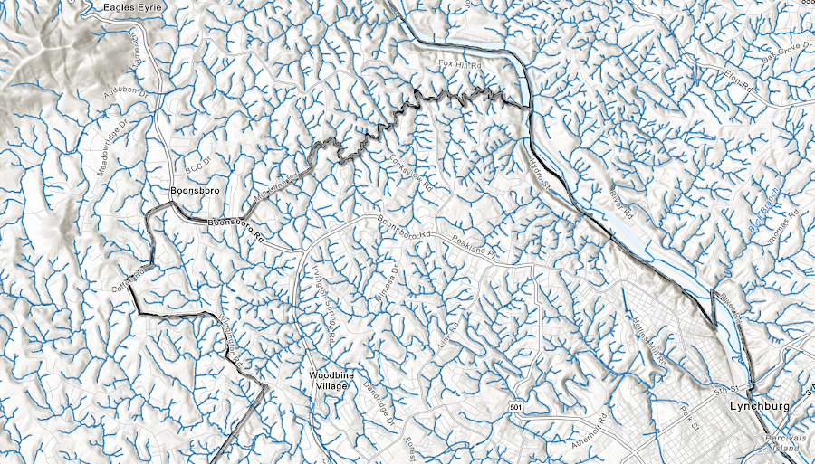
streams around Lynchburg have carved a dendritic drainage pattern
Source: Chesapeake Bay Program, CBP Data Project LULC and Hydrography Viewer
Trellis drainage patterns develop where there are alternating bands of harder and softer rock in folded layers. Small streams have perpendicular connections with larger streams.6
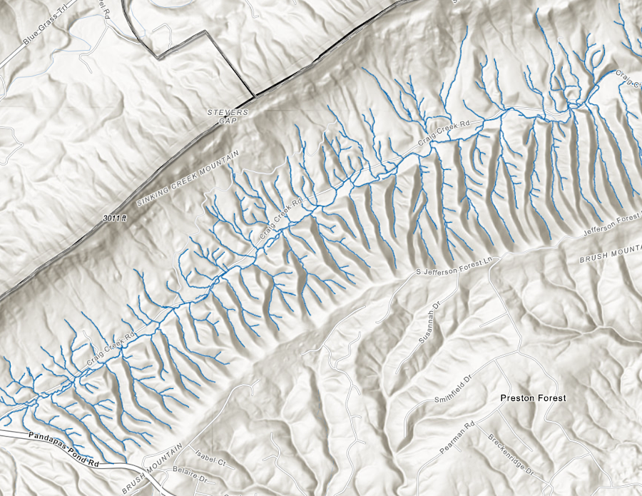
Craig Creek in Montgomery Couny has a trellis drainage pattern
Source: Chesapeake Bay Program, CBP Data Project LULC and Hydrography Viewer
salinity varies from fresh (less than 0.5 parts/thousand salt) to saline (35 parts/thousand) at the ocean
Source: Draft Tidal Wetlands Guidelines submitted to Virginia Coastal Zone Management Program (Figure 5)
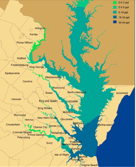
Chesapeake Bay watershed in Virginia
Source: Choose Clean Water (click on image for map of full watershed)
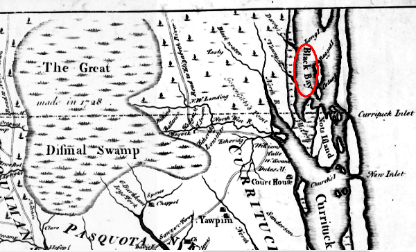
the North Carolina surveyor who marked the Virginia-Carolina border in 1728 identified Back Bay as "Black Bay"
Source: East Carolina University, New and Correct Map of the Province of North Carolina by Edward Moseley (1733)

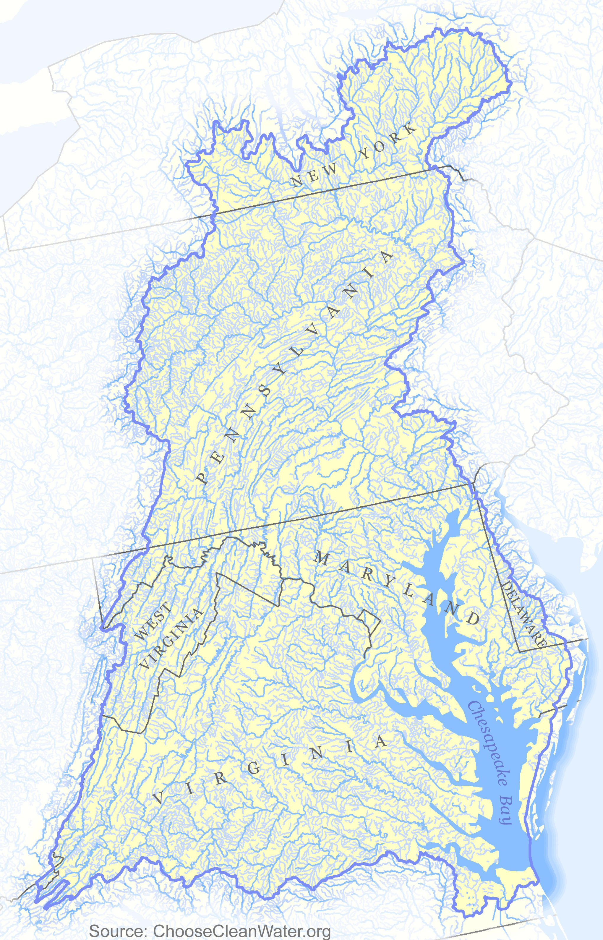
watersheds in southwestern Virginia
Source: Virginia Department of Conservation and Recreation, River Basins in Virginia
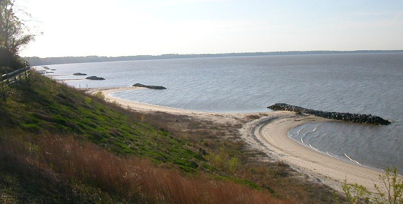
groins on James River, to reduce erosion
at Fort Boykin (Isle of Wight County)
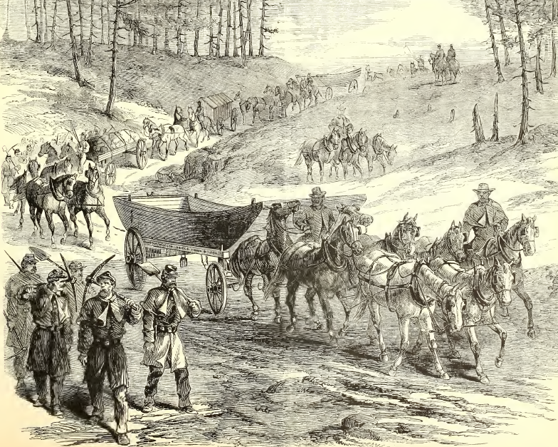
during the Civil War, Union forces carried pontoons to build temporary bridges across rivers in Virginia
Source: Frank Leslie's Illustrated History of the Civil War, The Pontoon Bridge "On The March" - The Pontoon Wagons On Their Way From Aquia Creek To The Rappahannock (p.343)
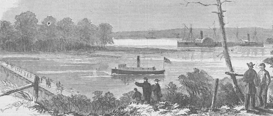
pontoon bridges temporarily blocked steamships from using stretches of rivers
Source: HathiTrust, Harper's Weekly, Jones Neck, From General Foster's Headquarters Near Malvern Hill On the James (July 23, 1864, p.468)