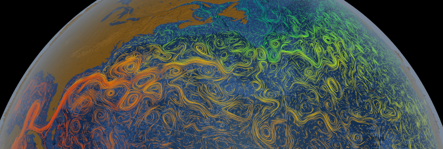
ocean flows colored with sea surface temperature data
Source: National Aeronautics and Space Administration (NASA) Scientific Visualization Studio, Gulf Stream Sea Surface Currents and Temperatures
ocean flows colored with sea surface temperature data
Source: National Aeronautics and Space Administration (NASA) Scientific Visualization Studio, Gulf Stream Sea Surface Currents and Temperatures
When the earth first cooled to create a crust 4.6 billion years ago, comets and asteroids brought water. Within 150 million years, the surface consisted of one ocean. Earth was a water planet until lighter crust differentiated and chunks of continental crust appeared above the surface. More silica-rich crust has formed over the years, and the movement of tectonic plates creates periods when the percentage of above-water continents vs. ocean will change.
When the chunks of continental crust clustered together to form the supercontinents of Rodinia and Pangea, one large ocean covered the rest of the earth. With the breakup of Pangea and the creation of today's continents, the Panthalassic Ocean has been subdivided into smaller oceans. The Pacific Ocean now covers 30% of the earth's surface, and:1
Source: (NASA), The Ocean: A Driving Force for Weather and Climate
The Atlantic Ocean began to form as the supercontinent Pangea split up about 180 million years ago near the end of the Triassic Period. A series of rift valleys, created as the crust stretched, eventually combined and filled with seawater. Magma rising up into the rift valleys continued to emerge, creating what today is the Mid-Atlantic Ridge. Basalt has emerged for 180 million years as the tectonic plates have continued to separate.
The oldest basalt on the Atlantic Ocean seafloor is next to the East Coast. It emerged when Pangea was first splitting, and has been next to the edge of the continental crust while the ocean floor has expanded. The youngest bedrock on the Atlantic Ocean seafloor is forming right now in the middle of the ocean at the Mid-Atlantic Ridge, midway between the North American/South American and the Eurasian/African plates.
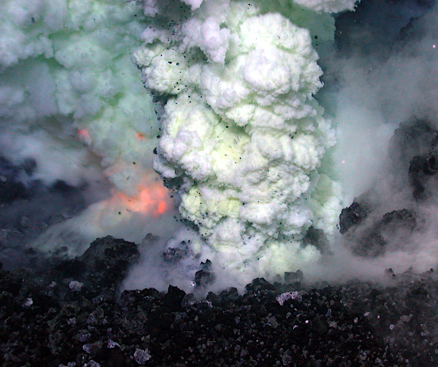
every day, new basalt rises up within cracks in the ocean floor
Source: National Oceanic and Atmospheric Administration (NOAA), Lau Basin Multimedia
The ocean continues to widen about one inch per year on each side of the Mid-Atlantic Ridge, as lava emerges and helps to push Europe and North America further apart. The Mid-Atlantic Ridge is the longest mountain chain on earth, extending for 10,000 miles. The lava erupting from it has created the bottom of the Atlantic Ocean over the last 180 million years, starting when the supercontinent Pangea split up.
In contrast, the continental crust of Virginia is as more than one billion years old in places such as Old Rag Mountain in the Blue Ridge. The formation of the lighter, silica-and-feldspar-rich continental crust began long before the oldest basalt crystalized on the seafloor of the Atlantic Ocean.
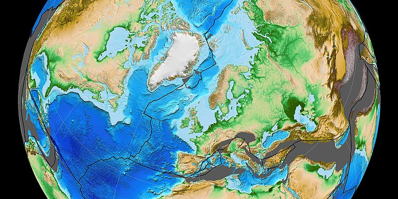
the bedrock of the Atlantic Ocean is only 180-200 million years old, far younger than the continents which border it
Source: Wikipedia, Laurasia (by Fama Clamosa)
Mountainous ridges similar to the Mid-Atlantic Ridge are underneath other oceans at the edge of tectonic plates. Scientists in the 1970's discovered hydrothermal mineral deposits and exotic forms of life at hot springs on the ridges, at depths where chemosynthesis rather than photosynthesis was the source of food. Vents known as "black smokers" release water as hot as 780°F, and reveal how some ore deposits are formed.
The underwater ridges are the site of 70% of earth's volcanic eruptions:2
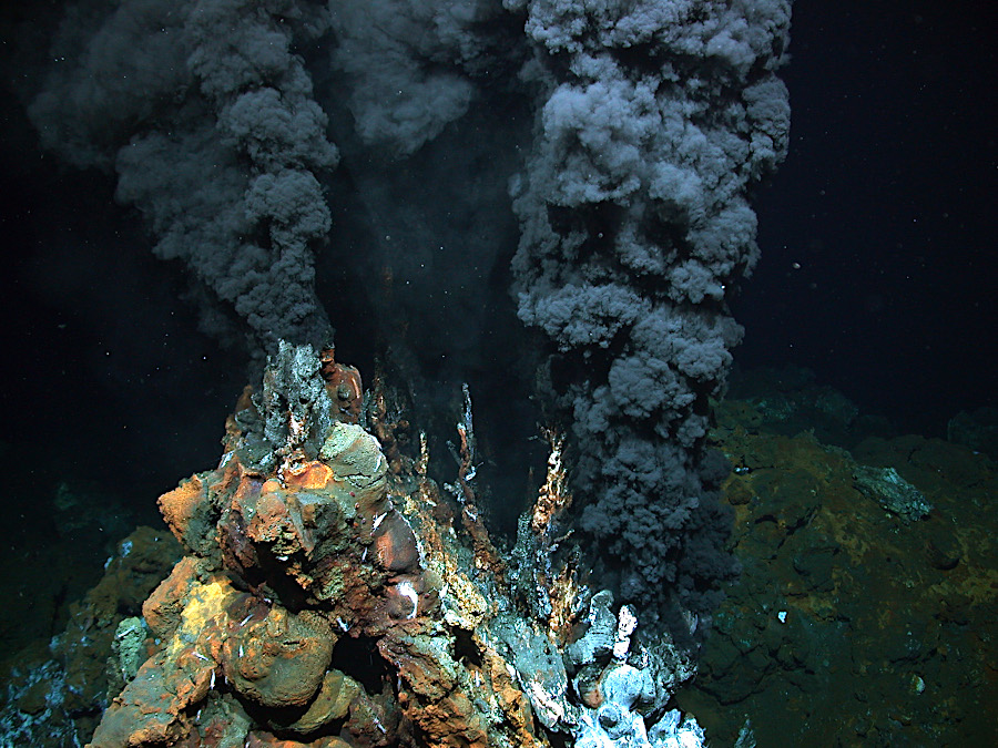
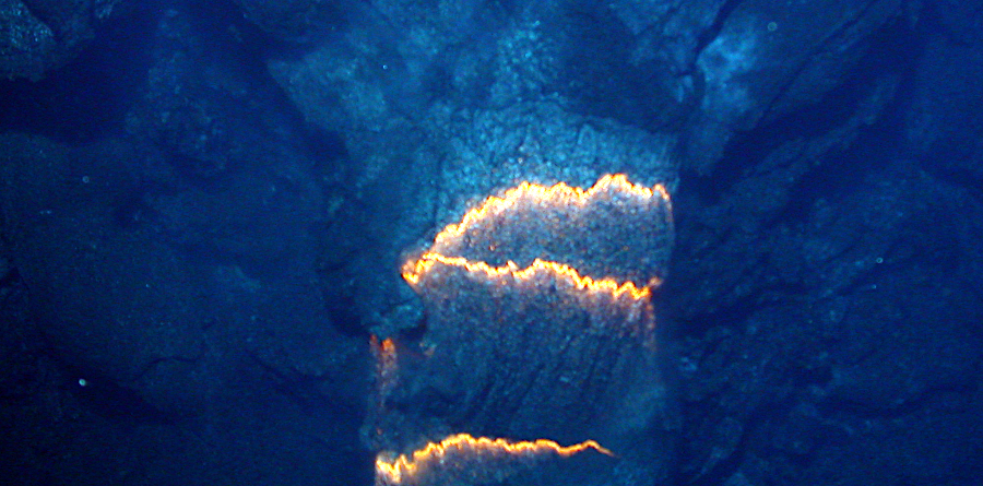
black smoker on the mid-Atlantic ridge at a depth of 2,980 meters
Source: University of Bremen, Deep Sea
The currents in the ocean have changed dramatically over 200 million years as the continents have realigned and the seafloor has widened. Though the Atlantic Ocean is roughly 180 million years old, the Gulf Stream has existed for only 2.5 million years. That is when tectonic movements brought the Cocos, Panama, North Andes, South American, and North American plates close enough to create the Isthmus of Panama, linking a peninsula of southern Central America with South America.
Panama cut off the flow of warm water near the Equator between the Atlantic and Pacific oceans. Water in the Caribbean moved north in a clockwise direction around Cuba, then through the Straights of Florida and northward along the eastern edge of the North American continent. After land masses merged and cut off the ocean current flowing between the Atlantic and Pacific oceans, the Gulf Stream was formed.3
Today, the Gulf Stream is a current of warm water, sometimes 15-20°F warmer than the adjacent water, flowing north from Cape Hatteras. The water is heated originally as it moves westward from Africa in the North Equatorial Current, before splitting. Some warm water flows back east in the North Equatorial Counter Current. Other water continues westward with the Caribbean Current into the Gulf of Mexico.
Source: Kurzgesagt – In a Nutshell, The Gulf Stream Explained
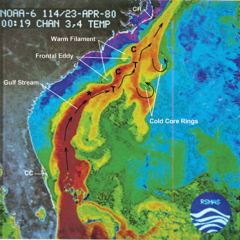
The Caribbean Current evolves into the Loop Current and then the Florida Current, which flows north along the East Coast. Near Cape Hatteras at latitude 32°N, the Florida Current is deflected offshore by a topographic irregularity in the seafloor known as the Charleston Bump. The character of the current changes, with less eddy variability. North of Cape Hatteras the warm water flow is called the Gulf Stream.
The Gulf Stream flows at an average of four miles per hour (6.4 kilometers per hour), in the latitudes including Virginia. Further north, as it widens, the current slows to one mile per hour (1.6 kilometers per hour). The amount of warmer-than-average, saltier-than-average water carried north from Florida is greater than the volume carried by all of the world's rivers combined. The Antarctic Circumpolar Current around Antarctica carries far more water, and is the most powerful current among all of those that create the Great Ocean Conveyor Belt.

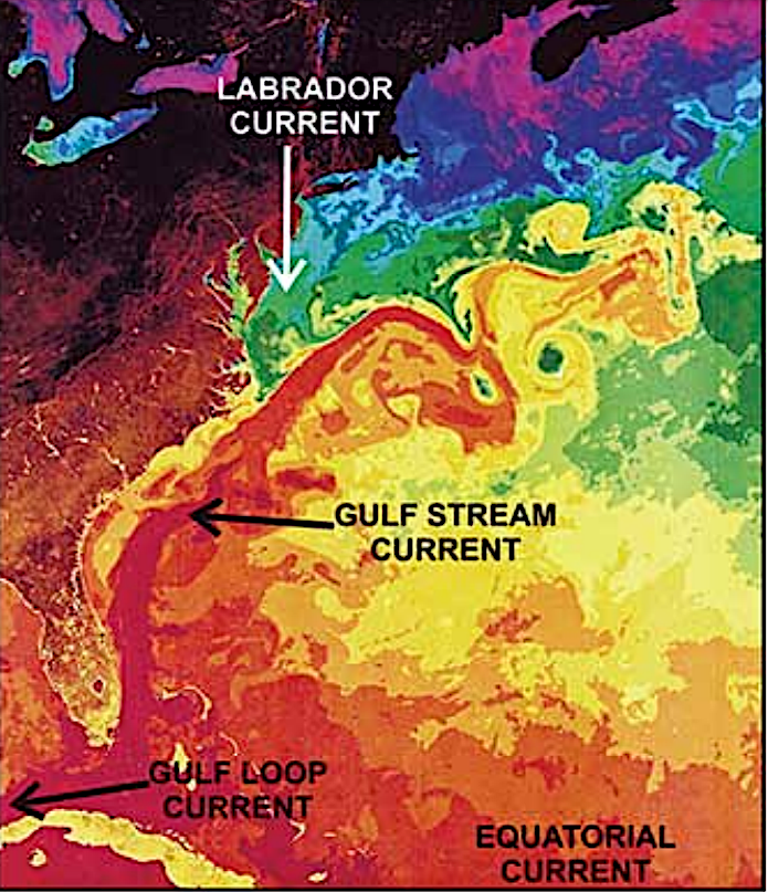
the Gulf Stream starts north of Cape Hatteras and flows on the western edge of the North Atlantic Gyre, isolating the Sargasso Sea from connection with North America
Source: Atlas of World Maps, United States Army Service Forces, Ocean Currents and Sea Ice (1943)
the west-flowing North Equatorial Current brings warm water to the Caribbean, and the Florida Current/Gulf Stream flow north from Cuba
Source: North Carolina, Report of the Governor's Scientific Advisory Panel on Offshore Energy (Figure 7-2)
The Florida Current and Gulf Stream, with various meanders and eddies, warms the eastern edge of the North American continent in winter. That heat exchange is part of the entire Atlantic Meridional Overturning Circulation (AMOC), where cold water from the Arctic and warm water from the tropics transfer energy around the globe.
The Deep Western Boundary Current (not the Labrador Current) brings cooler water south from the Mid-Atlantic Bight off New Jersey/Maryland to Cape Hatteras. Maine lobsters are caught north of Cape Hatteras, while Florida lobsters are caught to the south.
the south-flowing Deep Western Boundary Current brings cool water south to Cape Hatteras
Source: Frontiers in Marine Science, North Atlantic Western Boundary Currents Are Intense Dissolved Organic Carbon Streams (Figure 1)
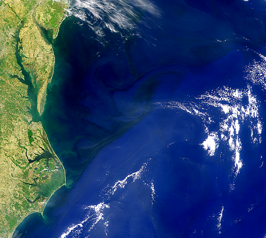
Where the Gulf Stream moves eastward into the Atlantic Ocean, deeper water rises to the surface near the shoreline. Swimmers on vacation at the Outer Banks in North Carolina may be surprised to experience the colder water from the depths, rather than the warm water of the Gulf Stream.4
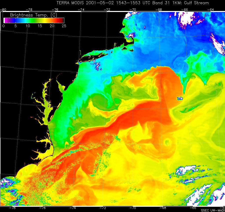
ocean flows colored with sea surface temperature data (red pixels are warmer areas approaching 25° C, greens are intermediate values of 12-13° C, and blues are less than 10° C)
Source: National Aeronautics and Space Administration (NASA) Scientific Visualization Studio, Gulf Stream's Brightness Temperature (May 2, 2001)
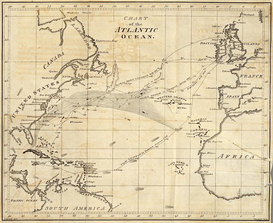
The flow of the Gulf Stream affects shipping patterns. In 1768, Benjamin Franklin examined why British mail ships were slower than merchant ships that sailed across the Atlantic Ocean. Franklin was serving as Deputy Postmaster General in the colonies, so he had a professional interest as well as scientific curiosity.
Franklin explored the question with his cousin Timothy Folger, a Nantucket ship captain with an understanding of ocean currents from personal experience and from discussions with American whalers. Franklin realized that merchant sea captains minimized the time they spent sailing within the Gulf Stream, while British ship captains responsible for carrying the mail ignored the current.
Franklin and Folger produced an accurate map documenting the location of the Gulf Stream. British mail ship captains reportedly ignored the information since it came from just a "colonial," but in the American Revolution French ship captains took advantage of the map.5
Benjamin Franklin and his cousin Timothy Folger documented that sailing in the Gulf Stream could increase time required to cross the Atlantic Ocean to North America
Source: Library of Congress, Franklin-Folger chart of the Gulf Stream (Benjamin Franklin and Timothy Folger, c.1769-1770)
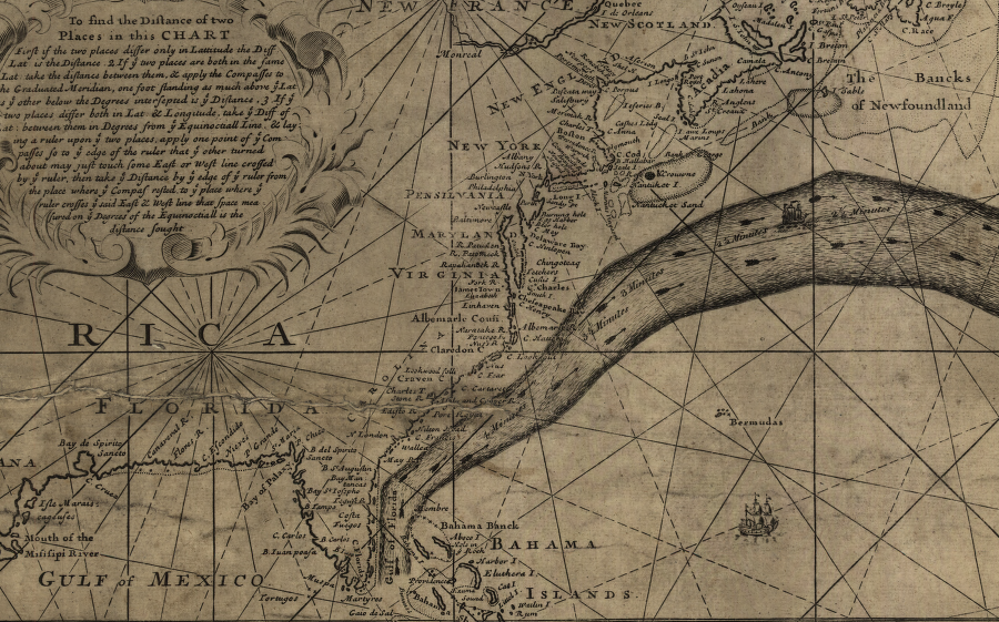
The Spanish understood the benefits of using the Gulf Stream long before the English. Ponce de Leon may have been the first to recognize and use it, in 1513. Throughout the 16th Century, Spanish treasure fleets sailed through the straights between Florida and the Bahamas, then north past Bermuda, because the current sped the journey eastward towards Seville.6
The Spanish treated their "Padron Real" and other maps as state secrets. As a result, Benjamin Franklin often gets credit for "discovering" the Gulf Stream that many Spanish pilots and ship captains had utilized effectively for over 150 years before Franklin and Folger published their map.7
ship captains sailing east to Europe took advantage of the Gulf Stream current
Source: David Rumsey Historical Map Collection, Chart of the Atlantic Ocean (by John Melish, 1812)
The flow of the Gulf Stream may lower the sea level on Virginia's coastline, by pulling ocean water eastward and away from the edge of the continent. In 2015, Hurricane Joaquin slowed the speed of the Florida Current between Florida and the Bahamas. In Hampton Roads, without the Gulf Stream flowing at its normal speed, high tides were as much as 3 feet higher than predicted.8
The Atlantic Meridional Overturning Circulation (AMOC) is not a stable, unchanging pattern. Currents that transport warm and salty water north, such as the Gulf Stream, are affected by global climate change. Freshwater runoff into the North Atlantic changes salinity and temperature. The "conveyor belt" pattern where salty water cools, becomes more dense and sinks, then returns along the ocean bottom to the equator may be altered if water densities change:9
The Younger Dryas cold period, between 14,500-11,500 years ago, may have reflected an interruption in the Atlantic Meridional Overturning Circulation when meltwater from the North American ice sheet was redirected. Instead of flowing down the Mississippi River into the Gulf of Mexico, cold water runoff escaped through the St. Lawrence River and altered the temperature and salinity gradients which power the ocean currents. Meltwater from Greenland could create a similar impact, acting like a climate switch.10
Close scientific monitoring of the Atlantic Meridional Overturning Circulation pattern dates back only to 2004, but examination of ocean sediments allows an assessment of changes over time dating back far longer.
The Atlantic Meridional Overturning Circulation can become stronger and begin to flow beyond Iceland. During such Dansgaard-Oeschger events, temperatures in Greenland can become 18-27°F warmer within a decade.
red shows near-surface transport and blue shows return flow at depth of the Atlantic Meridional Overturning Circulation
Source: Met Office, Risk management of climate thresholds and feedbacks: Atlantic Meridional Overturning Circulation (AMOC) (May 2, 2001)
The ocean currents may have begun weakening in the mid-1800's. A scientific report in 2018 concluded the Gulf Stream was at a low point, 15% slower than 1,600 years ago. The impact of a slower Gulf Stream is that waters off the Virginia coast are warmer, species of fish are changing, and sea level alongside the Virginia coastline is higher. However, a 2025 study concluded that the current transporting large amounts of heat northward had been stable for the last 60 years. The interpretation of computer models varied in part because different data was used, and because short-term and long-term variances were hard to distinguish.
The potential for disruption of the Atlantic Meridional Overturning Circulation (AMOC) pattern is unclear. The ocean circulation pattern could change quickly, and:11
fish congregate at the edge of the Gulf Stream and its eddies
Source: National Oceanic and Atmospheric Administration (NOAA), Ocean Explorer
The Younger Dryas was one of the Heinrich events, which occur when the Atlantic Meridional Overturning Circulation shuts down due to the flow of cold freshwater. Before the Younger Dryas, ice dams blocked the meltwater from the retreating Laurentide Ice Sheet from flowing freely into the Atlantic Ocean. The dams that created proglacial Lake Agassiz broke, reformed, and broke again multiple times. With each break, massive amounts of cold water flooded out of Canada.
When the water moved through the Hudson Bay rather than the Mackenzie River channel, the cold water in the North Atlantic displaced the warm water of the Gulf Stream. The Northern Hemisphere cooled until ocean circulation patterns were restored after about 1,000 years. Before the Younger Dryas cooling period ended 11,700 years ago, many species of megafauna such as mastodons and mammoths went extinct.
The Intergovernmental Panel on Climate Change has proposed that North Atlantic currents would be stable through the 21st Century, while other scientists suggested that climate change would break the pattern by 2050.
If the Atlantic Meridional Overturning Circulation was blocked again, sea level would rise on North American coastline because warmer water occupies more space. Temperatures in the tropics would be higher, while temperatures in northern Europe would be lower:12
If a warmer climate disrupts the Atlantic Meridional Overturning Circulation pattern, warm and cold waters with different levels of salinity will find a new equilibrium. New currents could replace the Gulf Stream. A different set of currents distributing heat from the Equator to the North Pole might ameliorate the cold temperatures at high latitudes in the middle of the ocean, but have less of an impact on the continents.
If aggressive human action somehow managed to reduced carbon dioxide levels in the atmosphere to 400 parts per million or lower, the climate would not revert to "normal" quickly. If the existing Atlantic Meridional Overturning Circulation had been disrupted, it might not be re-established. A new equilibrium could develop, with different currents based on new patterns of density, salinity, and temperature.13
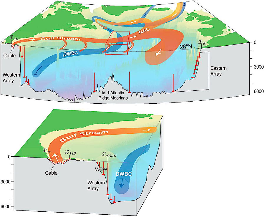
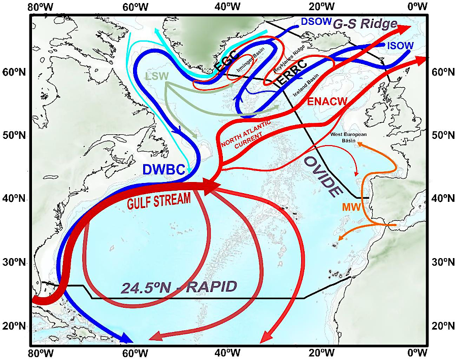
Atlantic Meridional Overturning Circulation (AOMC) with the warm Gulf Stream, the North Atlantic Current (NAC), and Labrador Current in red, and the cold Deep Western Boundary Current (DWBC) in blue
Source: American Geophysical Union, Observations, inferences, and mechanisms of the Atlantic Meridional Overturning Circulation: A review (by Martha W. Buckley and John Marshall)
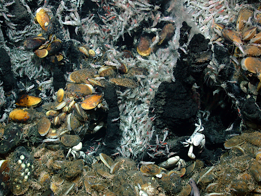
a hydrothermal vent on the Mid-Atlantic Ridge almost two miles deep - far from sunlight - harbors a closely integrated community of living organisms
Source: University of Bremen, Deep Sea
the Gulf Stream brings more-saline water, as well as warmer water, north from the Caribbean
Source: National Ocean Service, OceanViewer (Sea Surface Salinity - RTOFS, May 19, 2022)
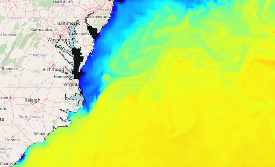
ocean colors reveal how the Gulf Stream veers away from the continent at Cape Hatteras
Source: National Aeronautics and Space Administration (NASA) Visible Earth, Gulf Stream