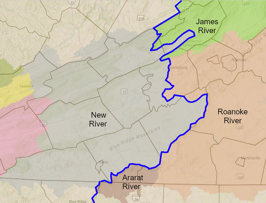
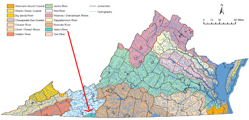
in Virginia, the Eastern Continental Divide separates the watersheds of the Ararat/Roanoke/James rivers from the New River watersheds
Source: ESRI, ArcGIS Online
in Virginia, the Eastern Continental Divide separates the watersheds of the Ararat/Roanoke/James rivers from the New River watersheds
Source: ESRI, ArcGIS Online
The most famous watershed divide in the United States may be the "Continental Divide" in the Rocky Mountains. It separates waters that flow to the Pacific Ocean vs. wates that flow to the Gulf of Mexico.
The very first Americans to cross that Western Continental Divide were recent immigrants from Beringea. They had traveled south along the Pacific Coast shoreline, then migrated inland. The first humans to cross the Continental Divide in the Rocky Mountains, or perhaps near the Gulf of Mexico, were headed eastward in small hunting and gathering groups.
Roughly 20,000 years later, the first citizens of the United States to cross the Continental Divide were led by two Virginians, Meriwether Lewis and William Clark. They crossed the divide separating the Mississippi River watershed and the Columbia River watershed at Lemhi Pass on the current Montana/Idaho border.
"The American explorers in 1805 were headed in the other direction from the first humans; Lewis and Clark were headed westward towards the Pacific Ocean. By then it was routine for the local Native Americans to travel back and forth across the Continental Divide in the Rocky Mountains.
Lewis and Clark were looking, in part, for the closest thing to a water-level passage connecting the Mississippi River with the salt water Pacific Ocean. Under the guidance of President Thomas Jefferson, the explorers followed the Missouri River upstream. They never realized that the topography of the Rockies would offer a far-better alternative at South Pass, and no canal would ever connect the Missouri River to the Columbia.
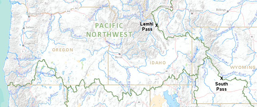
Lewis and Clark first crossed the western continental divide on the current Montana/Idaho border, north of South Pass used by later immigrants
Source: US Geological Survey (USGS), National Atlas Streamer
Many emigrants travelling to the west coast, including the '49's rushing to California after the discovery of gold, crossed at South Pass in modern-day Wyoming. Cross it on Interstate 80, and you'll hardly notice the shift from going uphill to downhill. Of course, that is why emigrants with only 4 horses instead of a Sport Utility Vehicle thought South Pass' gentle slopes were such a great choice compare to Lemhi Pass.
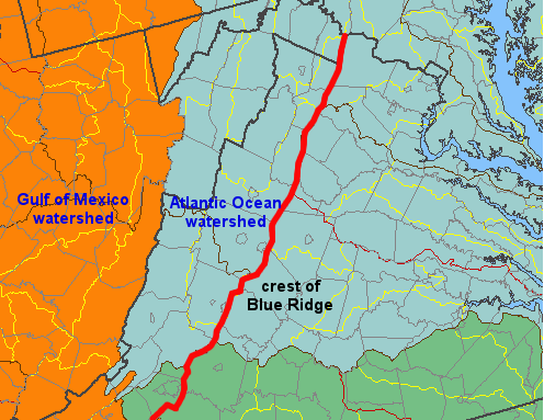
There are multiple continental divides in the United States, separating waters flowing into the Arctic Ocean, Pacific Ocean, Gulf of Mexico, and Atlantic Ocean. The Eastern Continental Divide cuts through Southwest Virginia. On the eastern side of the Eastern Continental Divide, raindrops that fall in the watersheds of the Ararat, Roanoke, and James rivers flow eventually ino the Atlantic Ocean. Raindrops that fall on the watershed on the New River, on the western side of the Eastern Continental Divide, flow into the Gulf of Mexico by way of the Mississippi River.
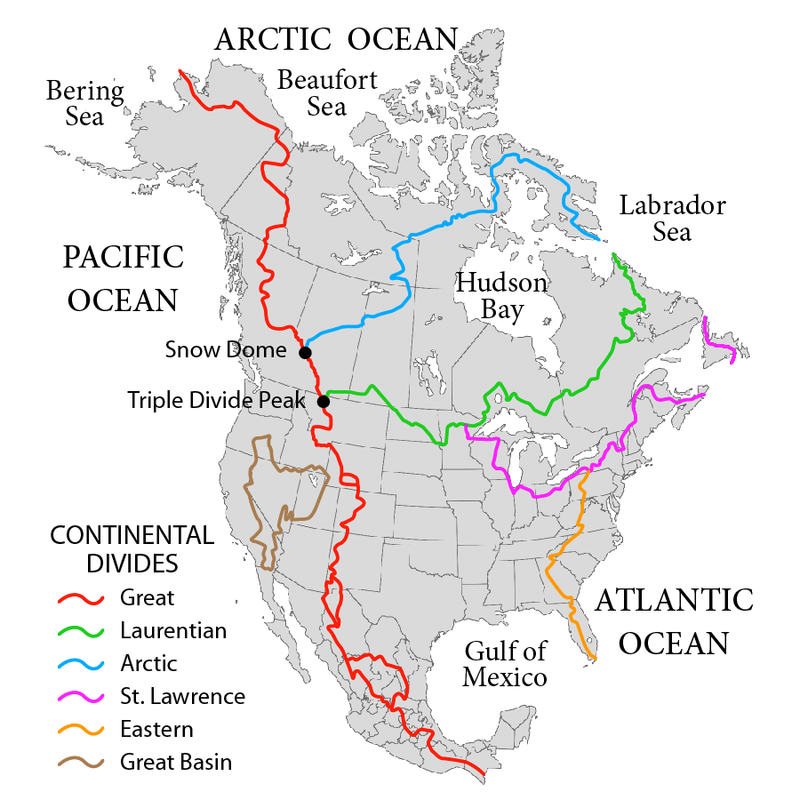
there are multiple continental divides in North America
Source: Wiktionary, Continental Divide
Drivers can go west on US 58 from the Atlantic Ocean to Cumberland Gap, paralleling the North Carolina border. Signs on bridges identify when the highway crosses over the Nottoway, Meherrin, Roanoke, New, Holston, Clinch, and Powell rivers, and many smaller streams.
Less obvious to travelers are the crossings of watershed divides, each defining the boundary of a watershed with streams and rivers flowing to the Atantic Ocean or Gulf of Mexico. The Eastern Continental marks the watershed boundary where rivers flow east towards the Chesapeake Bay/Atlantic Ocean or west towards the Mississippi River/Gulf of Mexico.
Drivers can go west on US 58 from the Atlantic Ocean to Cumberland Gap, paralleling the North Carolina border. Signs on bridges identify when the highway crosses over the Nottoway, Meherrin, Roanoke, New, Holston, Clinch, and Powell rivers, and many smaller streams.
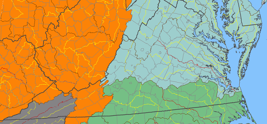
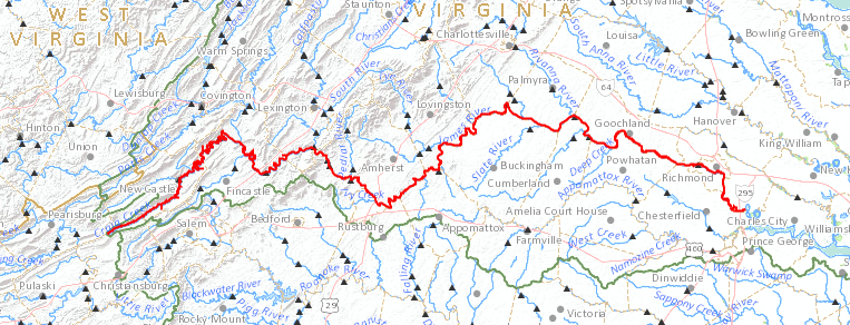
drivers headed west from Virginia Beach on Route 58, parallel to the North Carolina border, will cross four major divides separating the James River, Roanoke River, New River, and Tennessee River watersheds
Source: US Geological Survey (USGS), National Atlas
Less obvious to travelers are the crossings of watershed divides, each defining the boundary of a watershed with streams and rivers flowing to the Atlantic Ocean or Gulf of Mexico. The Eastern Continental marks the watershed boundary where rivers flow east into the Atlantic Ocean or west into the Gulf of Mexico.
The Eastern Continental Divide crosses Virginia from Carroll County at the North Carolina line to Giles County at the West Virginia border. Rainwater in most of southwestern Virginia flows to the Gulf of Mexico, not to the Atlantic Ocean.
There is a watershed divide on Route 11/I-81 between the New River and the Holston, Clinch, and Powell rivers, the three rivers in Virginia's upper Tennessee River watershed. That divide is hard to recognize. The crest is at Rural Retreat, where the soft drink Dr. Pepper was invented, in Wythe County. It is the highest elevation on the original Virginia and Tennessee Railroad connecting Lynchburg and Knoxville, but the crest is so gentle that even a bicyclist on Route 11 would have to be paying close attention to notice the exact location of when uphill becomes downhill.
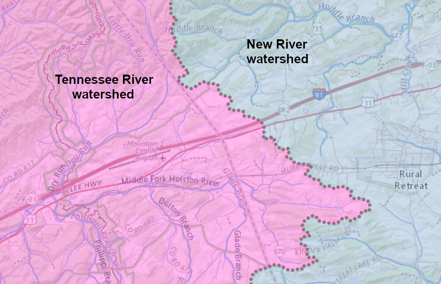
drivers on I-81 rarely notice when they have crossed the watershed divide separating the Tennessee and New rivers
Source: ESRI, ArcGIS Online
Many county and state boundaries are defined by watershed divides. The Eastern Continental Divide in Virginia partially separates Carroll County from Patrick County, and most of the eastern edge of Floyd County is defined by the divide.
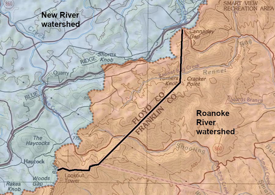
most - but not all - of Floyd County is in the New River watershed west of the Eastern Continental Divide
Source: ESRI, ArcGIS Online
In Giles and Craig counties, the zig-zag watershed boundaries of Sinking Creek and Johns Creek form the Eastern Continental Divide. However, the General Assembly chose to use straight lines to separate those two counties. The Virginia-West Virginia state line in the northeast corner of Giles County, separating it from Monroe County, is not based on the watershed boundary.
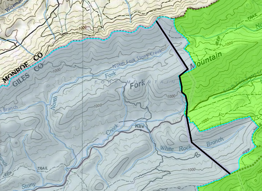
the Eastern Continental Divide does not define the Virginia-West Virginia boundary on the northeastern edge of Giles County
Source: ESRI, ArcGIS Online
Montgomery County is split by the divide. If you drive north into Blacksburg from I-81, most of US 460 follows the Eastern Continental Divide until the airport. Rain falling to the east of the highway (and on the new bypass) flows to the North Fork of the Roanoke River and down to Albemarle-Pamlico Sound in North Carolina. Rain to the west will drain into the New River. That water will flow through West Virginia, down the Ohio River, and go with the Mississippi River past New Orleans. After dropping a little bit of sediment from Montgomery County into the birdsfoot delta of the Mississippi River, the runoff from the Blacksburg airport, Gillies and other restaurants in downtown Blacksburg, and the Virginia Tech campus will finally enter the Gulf of Mexico.
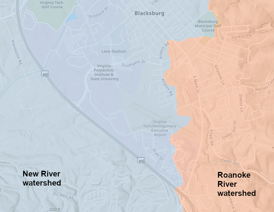
the Town of Blacksburg is on the Eastern Continental Divide
Source: ESRI, ArcGIS Online
Drivers who go from Blacksburg west on US 460 towards West Virginia will first climb to the crest of Brush Mountain, then drop down into a valley on the west side. At the bottom, before the road climbs up Sinking Creek Mountain, is an intersection with a sign for the US Forest Service recreation site at Pandapas Pond. That artificial pond marks the headwaters of Poverty Creek. It flows into Toms Creek and joins the New River at Whitethorne, roughly 500 feet lower in elevation.
At that intersection, Route 460 again marks the continental divide. Rain that falls on the north side of US 460 (on the opposite side of the highway from Pandapas Pond) will flow through Craig Creep, dropping roughly 1,100 feet before reaching the James River just upstream of Eagle Rock (halfway between Clifton Forge and Buchanan). From there, the water will drop another 1,200 feet before reaching sea level at Richmond.

James Pandapas dammed Poverty Creek to create a recreation site for his employees, and then later sold the pond to the US Forest Service
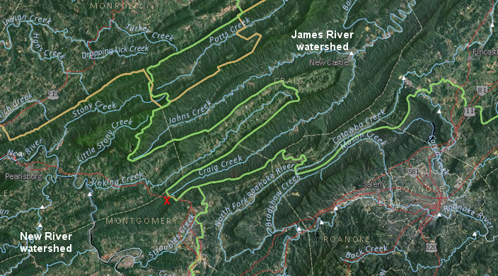
Eastern Continental Divide in Giles County, where Potts/Johns/Craig/Catawba creeks flow north to the James River rather than south towards the New River (red X marks location of Pandapas Pond)
Source: US Geological Survey (USGS), National Atlas Streamer
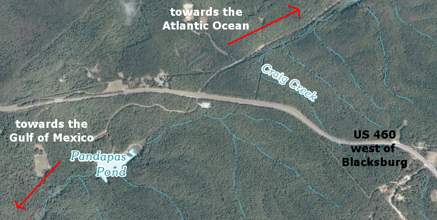
watershed divide between James and New rivers, west of Blacksburg (Pandapas Pond/Poverty Creek drain to New River)
Source: US Geological Survey, Newport 7.5x7.5 topographic quadrangle (2011)
Craig Creek and Poverty Creek are both eroding away at the ridge which separates them, the ridge on which US 460 runs. Craig Creek is likely to erode faster than Poverty Creek. The distance from the divide on US 460 to sea level (313 miles) is far less than the distance to the Gulf of Mexico (2,000 miles), but Craig Creek's capacity to etch into bedrock might be greater primarily because hard-to-erode layers in the bedrock of the New River reduce the erosive power of Poverty Creek.1
At some point in the future, perhaps a million or so years from now, Craig Creek will have carved its valley more than 500 feet deeper. It that happens faster than the New River cuts its channel, Craig Creek could intercept the New River. The upper New River would then be diverted to flow into the James River and on to the Atlantic Ocean, rather than to the Gulf of Mexico.
That potential act of "stream piracy," diverting the upper New River into the Chesapeake Bay watershed, would shift the location of the Eastern Continental Divide to the western edge of the New River watershed. The headwaters of the Tennessee River (the Holston, Clinch, and Powell rivers) would still carry water to the Gulf of Mexico, as would the New River downstream of the confluence with Craig Creek - but the "pirated" portion of the upper New River, east of Big Walker Mountain/Craig Creek, would become part of the Chesapeake Bay watershed.
if Craig Creek pirated the upper New River in perhaps a million years (and no other stream piracy occurred), the new Eastern Continental Divide would shift to the red line
Source: ESRI, ArcGIS Online
The hypothetical transformation of the watershed boundaries by piracy of the New River will not occur for thousands or even millions of years, if it ever does. However, such a shift in the continental divide has already occurred more than once.
US 58 climbs up the Blue Ridge at the Meadows of Dan and reaches the crest - not at the Blue Ridge Parkway, but east of the parkway at the Patrick/Floyd county line. That crossing is the Eastern Continental Divide. To the east, raindrops flow downhill to the Atlantic Ocean. To the west, water drains to the Gulf of Mexico via the New River or tributaries of the Tennessee River, ultimately flowing into the Mississippi River and going past New Orleans.
the eastern boundary of Floyd County is based on the Eastern Continental Divide
Source: US Geological Survey (USGS), National Atlas
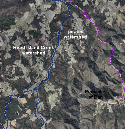
the Dan River pirated the headwaters of Reed Island Creek, diverting the water to the Atlantic Ocean and altering the Eastern Continental Divide
Source: Virginia Department of Conservation and Recreation (DCR), Virginia Hydrologic Unit Explorer
The headwaters of the Dan River used to flow westward into Reed Island Creek. The Dan River eroded the east side of the Blue Ridge faster than Reed Island Creek eroded the west side. Near the Pinnacles of Dan, the headwaters of the Dan River intercepted the headwaters of Reed Island Creek, and the location of the Eastern Continental Divide shifted when the watershed boundaries shifted.2
A more substantial change in the location of the Eastern Continental Divide occurred when the headwaters of the Potomac River were pirated about 5 million years ago. The beginning of the Potomac River used to be on the east side of the Blue Ridge. When erosion opened a gap through the Blue Ridge at Harpers Ferry, the Shenandoah River and the upper Potomac River were able to flow directly east to the Atlantic Ocean. The location of the Eastern Continental Divide moves by the natural process of erosion - the same process that created the divide in the first place.
a raindrop that flows into the headwaters of Craig Creek will drop 2,383 feet in its 313-mile trip to Tidewater
Source: US Geological Survey (USGS), National Atlas Streamer
The geological basis for the existence of the Eastern Continental Divide is still poorly understood. For 200+ million years, the Appalachians have eroded away. Why is there still an escarpment (the Blue Ridge) with significant topographic relief, instead of a flat eroded peneplain, between the Atlantic Ocean and the Midwest?
Some force has lifted up the Appalachians faster than erosion has cut down the mountains. Uplift has been fast enough so no river flows completely across the Appalachians. The New River starts in the middle of the Blue Ridge at Blowing Rock, NC and does not completely bisect the Blue Ridge.
It appears that for 200 million+ years, an Eastern Continental Divide has separated streams flowing westward towards the Mississippi River from streams flowing east to the Atlantic Ocean. Watershed boundaries have migrated as streams etched new paths and deposited sediments downstream, but the divide has not disappeared.
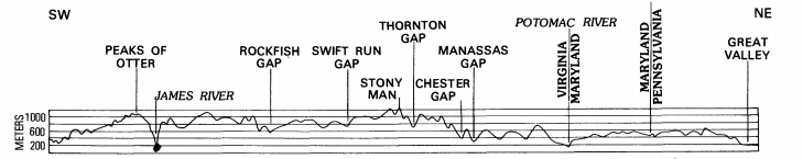
watershed boundaries reveal that, in most of Virginia, the Eastern Continental Divide separating Gulf of Mexico/Atlantic Ocean watersheds does not match up with the crest of the Blue Ridge
Source: US Geological Survey (USGS), National Atlas
The continental divide along the Blue Ridge south of 40° latitude apparently has been present for many millions of years, perhaps since the Cretaceous Period. At that time, when dinosaurs were wandering across the landscape, the Blue Ridge in southern Virginia may have been 13,000 feet high. Erosion has lowered the mountain heights, but the divide has remained essentially in the same place.3
north of I-66, the lower height of the Blue Ridge may be due to less uplift of the crust
Source: US Geological Survey (USGS), Physiographic Divisions and Differential Uplift in the Piedmont and Blue Ridge (Professional Paper No. 1265, Figure 19)
Different rates of erosion of different bedrock layers is a key reason some version of the Eastern Continental Divide has survived for so long, just like the Blue Ridge escarpment. Limestone formations, exposed in valleys to the west of the Blue Ridge, erode faster than the crystalline bedrock of the Blue Ridge.
Many watershed divides in the Valley and Ridge physiographic province owe their existence to the contrasting ability of rain/wind to erode hard sandstone layers vs. limestone. The hard sandstone mountains today (such as Massanutten Mountain east of Harrisonburg) are eroding, but eroding at a rate slower that the limestones. The valleys west of the Blue Ridge are etched out of softer rock than the adjacent mountains.
North of Roanoke, differential erosion can also explain the topographic relief of the Blue Ridge vs. the Piedmont to the east. The Blue Ridge is formed from volcanic/metamorphic formations that are substantially more resistant to erosion that the Piedmont bedrock. However, south of Roanoke, the bedrock in the Piedmont physiographic province erodes at essentially the same rate as the Blue Ridge, but there is a clear difference between the rolling hills of the Piedmont and the "ridge" to the west:4
Why? Theories include asymmetric uplift by tectonic forces along a fault at the base of the Blue Ridge, more-rapid erosion by streams draining east to the Atlantic Ocean, and "flexural isostasy" as sediments deposited along the Atlantic Ocean shoreline pushed down the crust there and triggered an uplift further inland.5
The East Coast has tilted towards the Atlantic Ocean since Africa pulled away and the ocean first formed. It appears the crust has warped during the tilting, so the Blue Ridge has been lifted higher than the Piedmont. There is a distinctive area of low gravity in the central and southern Appalachians, due perhaps to a change in thickness of the deep crust dating back a billion or so years to the Grenville orogeny.
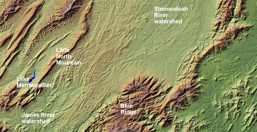
the watershed divide between the Shenandoah and James rivers at Raphine/Steeles Tavern is not obvious, in contrast to the Blue Ridge or subwatersheds defined by individual ridges in the Valley and Ridge physiographic province
Source: USGS Earth Resources Observation and Science (EROS) Center, National Elevation Dataset - Shaded Relief Map of Virginia
The Potomac and Jams rivers have cut gaps thrugh the Blue Ridge, but that topographic feature still defines the upper watershed boundary of the Ararat/Yadkin, New, and Rappahannock rivers. The York River has not eroded upstream enough to reach the Blue Ridge - yet.
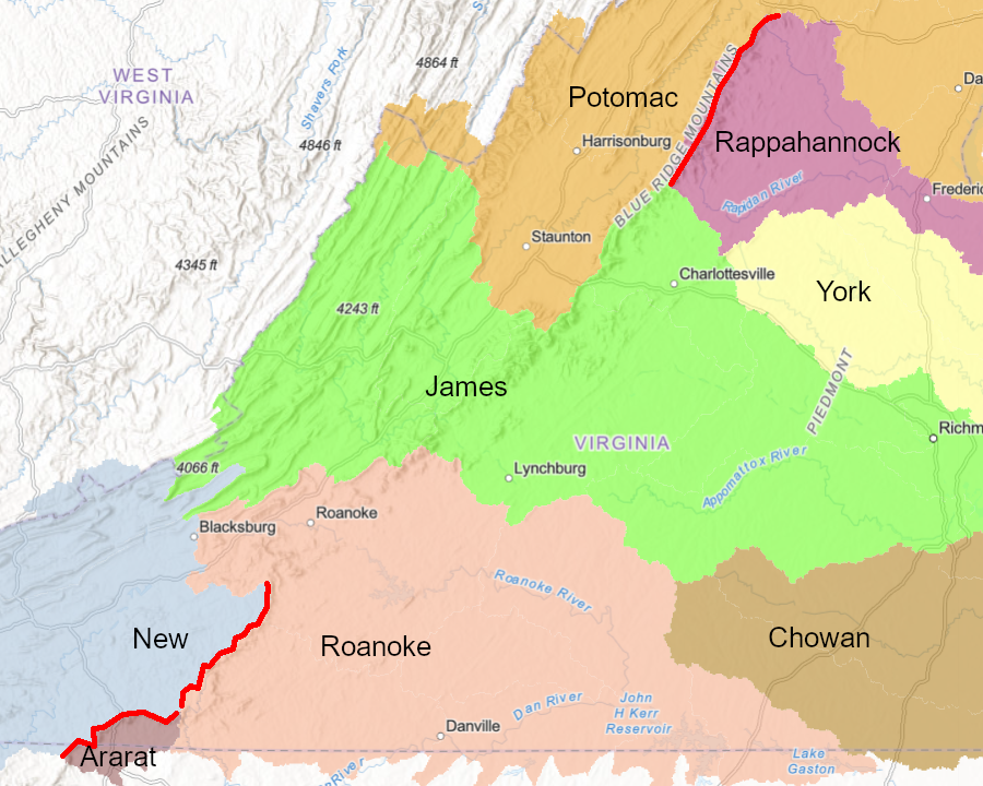
the Blue Ridge forms the watershed divide for the Ararat, New, and Rappahannock rivers - but not the James, Potomac, or York rivers
Source: ESRI, ArcGIS Online
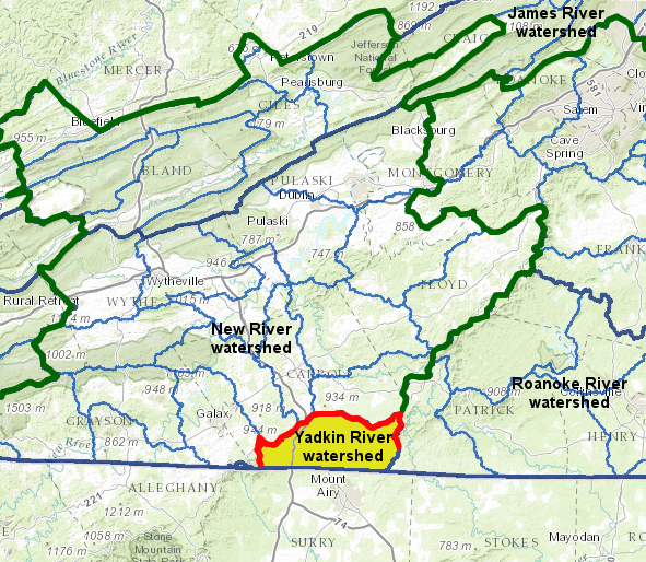
A tiny portion of Virginia drains into South Carolina and then the Atlantic Ocean via the Ararat River. The Ararat River, in the Yadkin River watershed, is on the eastern side of the Eastern Continental Divide in Patrick and Carroll counties. Only a prtion of the watershed divide is used to define the boundary between the two counties.
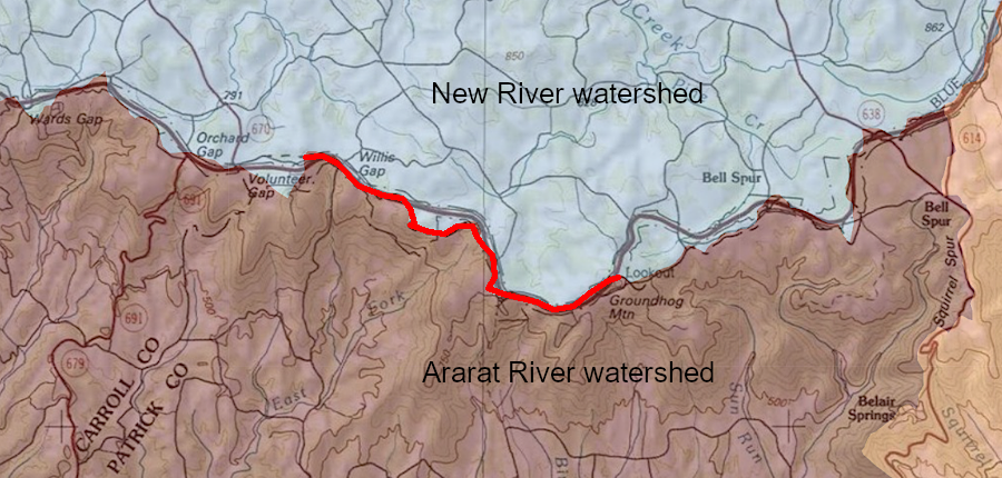
the General Assembly used only a portion of the Eastern Continental Divide to define the boundary between Patrick and Carroll counties
Source: ESRI, ArcGIS Online
The New River watershed is on the western side. The Ararat River and other streams flow through North Carolina into the Pee Dee River of South Carolina. Drivers on I-77 from North Carolina to Fancy Gap cross the only part of Virginia where rainwater flows 376 miles to reach the Atlantic Ocean in South Carolina, north of Charleston.6
some rain falling in Virginia flows into the Yadkin River in North Carolina, finally reaching the Atlantic Ocean via the Pee Dee River in South Carolina
Source: Virginia Department of Conservation and Recreation (DCR), 2007 Virginia Outdoors Plan - Virginia's Watershed Programs (p.162)
on the North Carolina border, the Eastern Continental Divide separates the Ohio (New River) and Pee Dee (Yadkin River) watersheds
Source: Virginia Department of Conservation and Recreation (DCR), Virginia Hydrologic Unit Explorer