Dragon Run: Virginia's Most Pristine Water Body
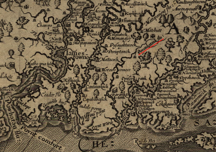
John Smith produced the first map showing the Piankatank River and the Dragon Run watershed (the Maltese cross indicates he personally explored the headwaters near Matchutt)
Source: Library of Congress, Virginia / discovered and discribed by Captayn John Smith, 1606
Dragon Run, 35 miles of swamp at the headwaters of the Piankatank River, may be the most pristine water body in Virginia, affected least by the changes in the landscape over the last few centuries. The Dragon Run Watershed Management Plan describes it as follows:1
- The Dragon Run is a brackish water, tidal/nontidal stream which flows forty miles through the Virginia Middle Peninsula counties of Essex, King and Queen, Middlesex, and Gloucester. Fed by underground springs, surface runoff and numerous feeder swamps, the Dragon Run twists and turns, meandering through the four-county area, eventually emptying at the headwaters of the Piankatank River. The stream, along with the surrounding Dragon Run Swamp, forms an ecologically unique system.
- A system of excellent water quality and numerous and diverse species of flora and fauna. It is characterized by dense stands of hardwoods with occasional upland ridges extending to the stream's edge. It supports both recreational fishing and excellent game and nongame wildlife. There is very little evidence of man's presence, essentially maintaining a primitive character throughout the entire system.
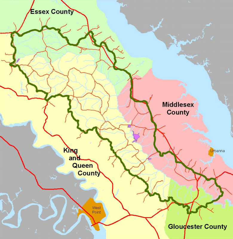
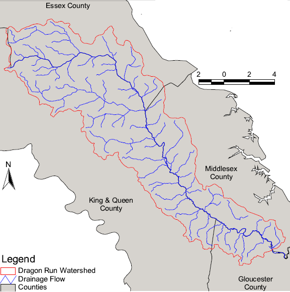
the Dragon Run watershed is on the Middle Peninsula, between the York River and the Rappahannock River
Source: Middle Peninsula Planning District Commission, The State of the Dragon Run Watershed: Status of Natural Resources (Figure 2)
At the end of the last Ice Age 18,000 years ago, the Piankatank River was one of many fresh-water tributaries draining into the Susquehanna River as it flowed south. Rising sea level flooded the valley of the Susquehanna River and converted a portion of it into the Chesapeake Bay, while the drowned mouth of the Piankatank River evolved into a part of Dragon Swamp.
Further upstream for 40 miles, the flat landscape had been created over millions of years. It was formed by the accumulation of eroded sediments from the Piedmont forming the Coastal Plain, by occasional transgressions of the Atlantic Ocean as far west as the Fall Line during which marine sediments were deposited, and by erosion that created a topography so flat that swamps developed. Tannins leach into the slow-moving water from decaying leaves of hardwood trees and bald cypress, creating "blackwater" swamps that send water gradually into Dragon Run.
the minimal number of housing units and minimal acres of impervious surface in the Dragon Run watershed makes it uniquely valuable as an ecological reference point
Source: ESRI, ArcGIS Online
When the Smithsonian Institution and The Nature Conservancy evaluated ecologically significant areas in the Chesapeake Bay area in 1974, the 140-square mile Dragon Run watershed was listed as the most pristine site in Virginia. Dragon Run was ranked as the second-most ecological significant area in the whole Chesapeake Bay, after Zekiah Swamp in Maryland.
After the Virginia General Assembly passed the Scenic Rivers Act of 1970, Dragon Run was the first stream to be studied. Local landowners objected to designation, fearing it would stimulate an unacceptable increase in use. While the area does not have many landowners asserting Kings Grant claims to submerged lands, concerns about property rights and potential trespass by boaters/anglers are a factor in the rural Middle Peninsula area.2
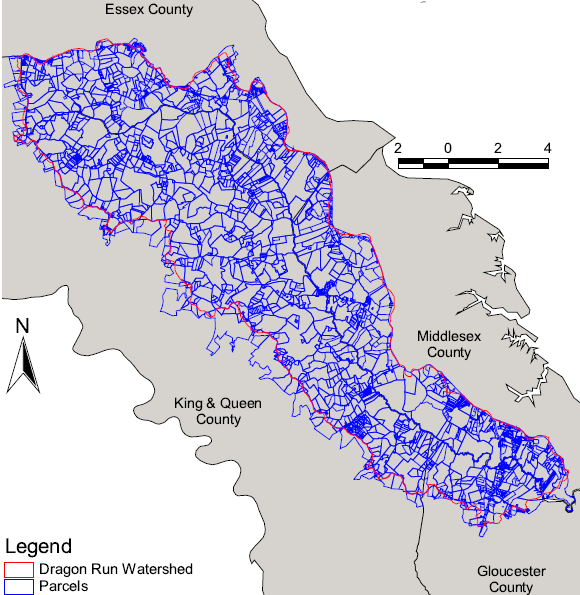
Dragon Run watershed parcel boundaries
Source: Middle Peninsula Planning District Commission, Dragon Run Management Framework
Land ownership is fragmented, but most parcels remain undeveloped. Currently there are only about 500 residences in the watershed. However, in the 1990's the Dragon Run watershed was zoned for nearly 40,000 housing units. The counties on the Middle Peninsula made extensive use of Geographic Information System (GIS) technology to determine how to revise existing Comprehensive Plans and zoning ordinances to protect the headwaters of the Piankatank River.3
The threat to Dragon Run is residential development, as urban residents seek to build second homes or retire to waterfront property on the Middle Peninsula. While development of one individual parcel will not wreck local ecology, the incremental cumulative impacts on wildlife, water quality, and other environmental components could transform the swamp. As noted by the Virginia Department of Environmental Quality:4
- Much of the Middle Peninsula serves as a bedroom community for out-commuting residents. Suburban sprawl from urban employment centers is now creeping into the region.
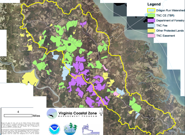
protected land in Dragon Run, as of 2010
Source: Virginia Department of Environmental Quality, Dragon Run SAMP FY 2008 Final Report
In 2010, The Nature Conservancy purchased over 13,000 acres from a timber company, equivalent to the size as Manhattan Island. The Nature Conservancy then re-sold the property to another timber company with a conservation easement ensuring high standards for forest management and timber harvest, protection of stream buffers, and reduced potential for future home development. The easement, at the time the largest in Virginia history, blocked development of up to 100 new houses.
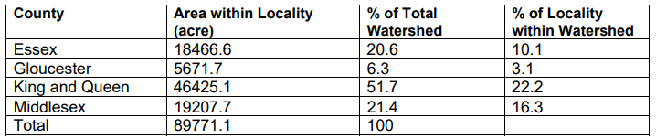
Essex, Gloucester, King and Queen, and Middlesex counties have cooperated though the regional planning commission to conserve much of the 140-square mile Dragon Run watershed
Source: Middle Peninsula Planning District Commission, Dragon Run Management Framework and The State of the Dragon Run Watershed: Status of Natural Resources (Table 1)
The forested lands purchased and resold by The Nature Conservancy stayed on the tax rolls as private land, but county officials worried that reducing land values with conservation easements would reduce county revenues from property taxes. The 13,000 acres qualified for land use taxation, already a reduced rate. A study by the Middle Peninsula Planning District Commission concluded that placing the acres into permanent conservation easement increased state funding to the counties for local schools:5
- ...by reporting a lower fair market value to the VaTAX for lands with conservation easements, the composite index should be lowered and the county should receive more State aid toward education.
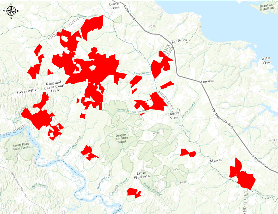
13,375 acres of timberlands in the Dragon Run watershed (marked in red) were protected by Virginia's largest conservation easement in 2010
Source: The Forestland Group, Dragon Run
The Dragon Run Conservation Estate Planning Network Initiative has been effective in obtaining conservation easements from local landowners, and 23% of the watershed is now protected. In addition, The Nature Conservancy has acquired property, including 1,800 acres transferred to the Virginia Department of Forestry in 2008 for the Dragon Run State Forest. That forest now includes over 9,000 acres.6
While the Dragon Run portion of the Piankatank River headwaters was relatively pristine, shellfish beds near the mouth of the river were contaminated by bacteria. The Virginia Department of Health has condemned some beds, blocking harvest of oysters and clams for sale. Several reaches of tributaries near the Piankatank River mouth were included in Total Maximum Daily Load (TMDL) studies in 2005-2006, after water quality testing revealed excessive levels of bacteria. At the time, there were no permitted point source discharges in the watershed. The source of bacteria was assumed to be wildlife, livestock, land application of biosolids, discharges from boats, and/or human wate from failed septic systems and "straight pipes" sending waste directly to streams.
Since them, the Department of Environmental Quality has issued Virginia Pollutant Discharge Elimination System (VPDES) permits for several facilities in the watershed, including the King and Queen County Sanitary Landfill.
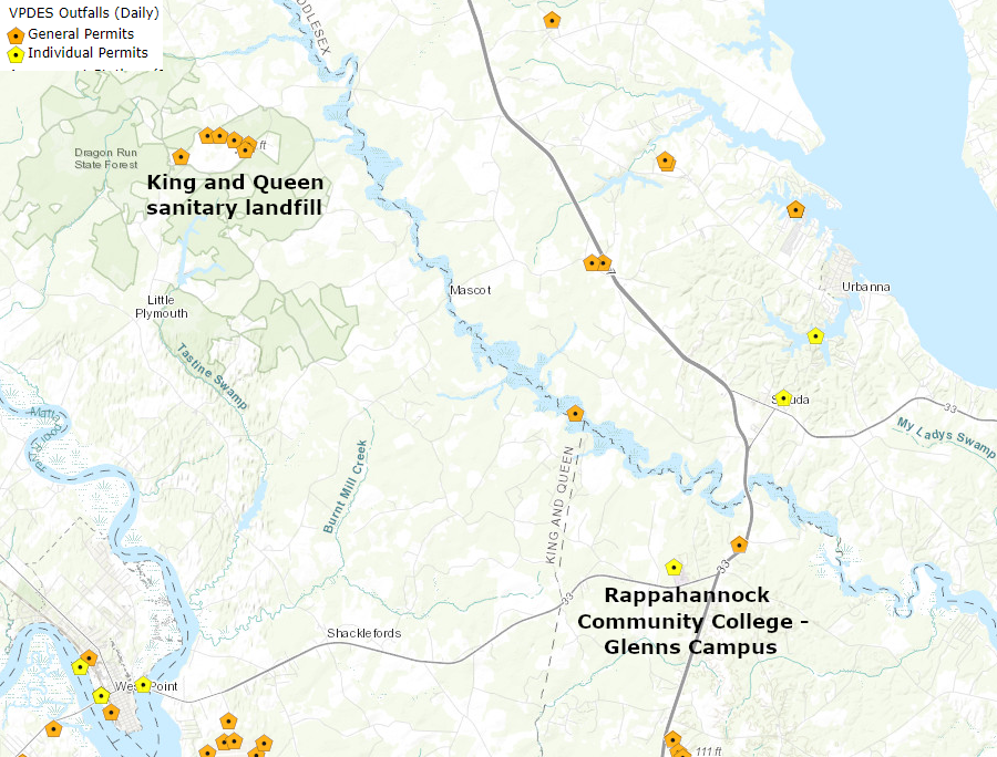
Virginia Pollutant Discharge Elimination System (VPDES) permits in the Dragon Run watershed authorize discharges from a sanitary landfill and a community college
Source: Virginia Department of Environmental Quality (DEQ), VEGIS
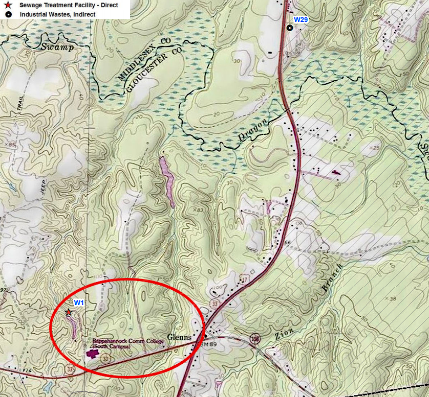
treated wastewater from the Rappahannock Community College now flows through Dragon Swamp to the mouth of the Piankatank River
Source: Virginia Department of Health, VEGIS
The extent of the impaired reaches in the 305(b)/303(d) Water Quality Assessment Integrated Report now reflect a more-granular assessment of which locations were contaminated, rather than successful actions to reduce excessive levels of bacteria.7
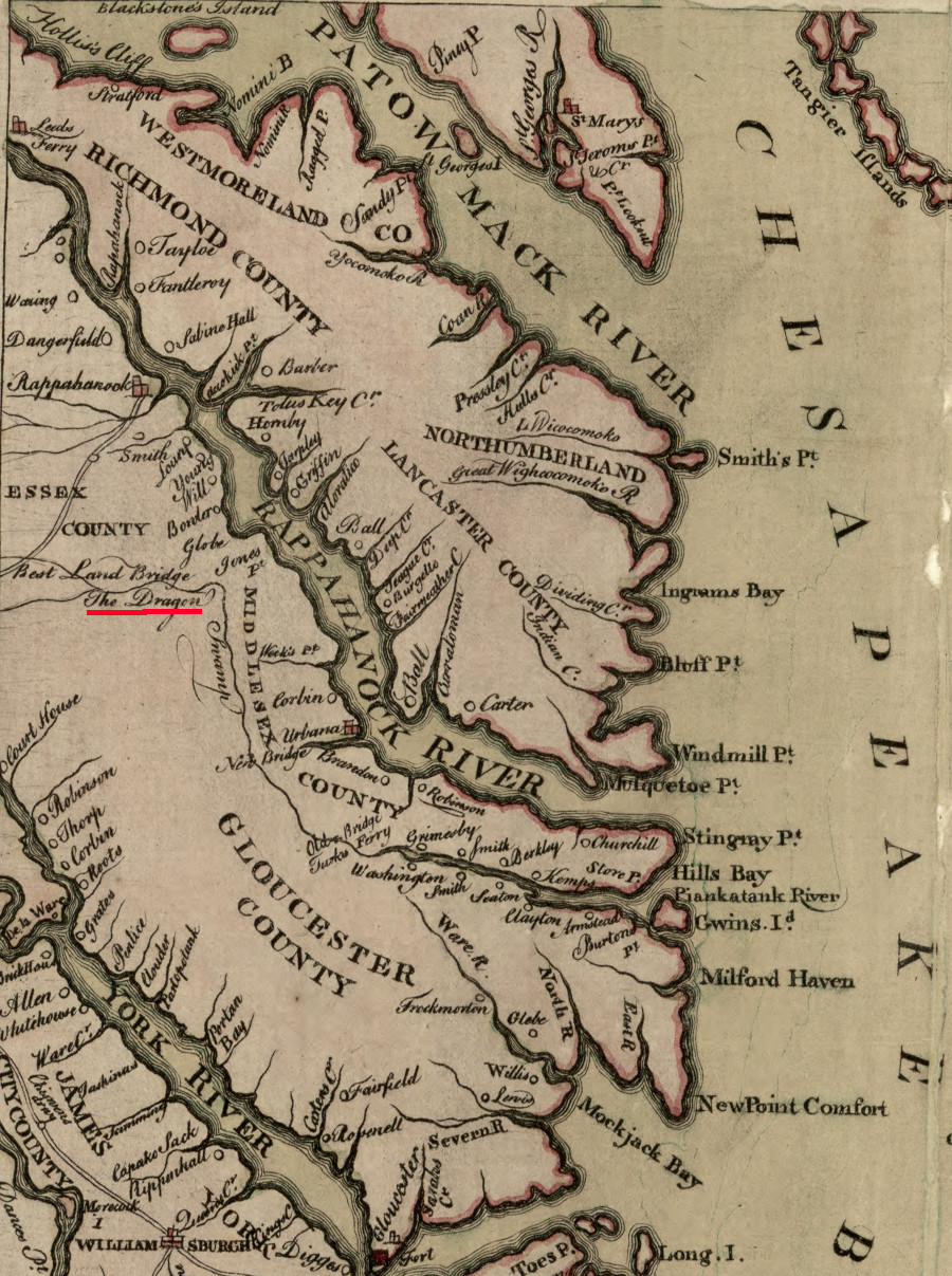
in 1776, the "best land bridge" crossing the headwaters of the Piankatank River was in Essex County
Source: Library of Congress, Map of the maritime parts of Virginia exhibiting the seat of war and of Ld. Dunmore's depredations in that colony (by Pierre EugŔne Du SimitiŔre, 1776)
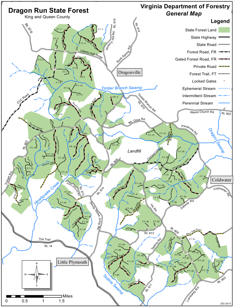
the Dragon Run State Forest in 2020
Source: Virginia Department of Forestry, Dragon Run State Forest
Links
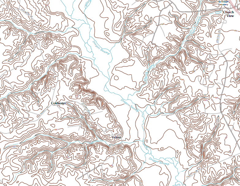
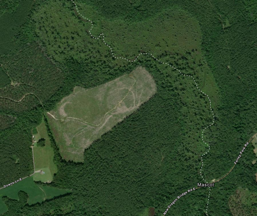
Dragon Run topography
Source: US Geological Survey (USGS), Church View 7.5x7.5 topographic quad map
References
1. "Dragon Run Watershed Management Plan," Middle Peninsula Planning District Commission, 1996, p.4, http://www.mppdc.com/dragon/docs/drmp96.pdf (last checked September 9, 2012)
2. "Dragon Run Watershed Management Plan," p.6, http://www.mppdc.com/dragon/docs/drmp96.pdf; "Natural Areas of the
Chesapeake Bay Region: Ecological Priorities," Smithsonian Institution, May 1974, p.20, p.55, https://archive.org/details/naturalareasofch00wash (last checked January 10, 2021)
3. "Dragon Run Watershed Management Plan," pp.20-21, http://www.mppdc.com/dragon/docs/drmp96.pdf (last checked September 9, 2012)
4. "Strategy: Dragon Run Special Area Management Plan," Virginia Department of Environmental Quality, http://www.deq.state.va.us/Portals/0/DEQ/CoastalZoneManagement/dragonstrat.pdf (last checked September 9, 2012)
5. "Easement conserves 13,350 acres in Dragon Run Swamp," Richmond Times-Dispatch, February 4, 2010, https://richmond.com/news/easement-conserves-13-350-acres-in-dragon-run-swamp/article_ab92b736-a4b6-5ac0-8570-908c8aa7b4da.html; "Dragon Run," The Forestland Group, https://www.tfgoperations.com/property/dragon-run/; "Middle Peninsula Conservation Corridor Plan," Middle Peninsula Planning District Commission, 2010, p.9, http://www.mppdc.com/articles/reports/Final_CC_Plan_Report_Red.pdf (last checked January 10, 2021)
6. "Dragon Run, Middle Peninsula," The Nature Conservancy, https://www.vof.org/2020/05/07/dragon-run-essex-king-and-queen-middlesex-and-gloucester-counties/; "Dragon Run State Forest," Virginia Department of Forestry, https://www.dof.virginia.gov/stateforest/list/dragon-run.htm (last checked January 10, 2021)
7. "Piankatank River Lower Watershed, Total Maximum Daily Load (TMDL) Report for Shellfish Condemnation Areas Listed Due to Bacterial Contamination," Virginia Department of Environmental Quality, February 2005, https://www.yumpu.com/en/document/view/15402180/tmdl-for-the-lower-piankatank-river-the-virginia-department-of-; "Appendix 3 - Final 2020 305(b)/303(d) Water Quality Assessment Integrated Report," Virginia Department of Environmental Quality, 2020, https://www.deq.virginia.gov/water/water-quality/water-quality-assessments/most-recent-year-305b-303d-integrated-report (last checked January 10, 2021)
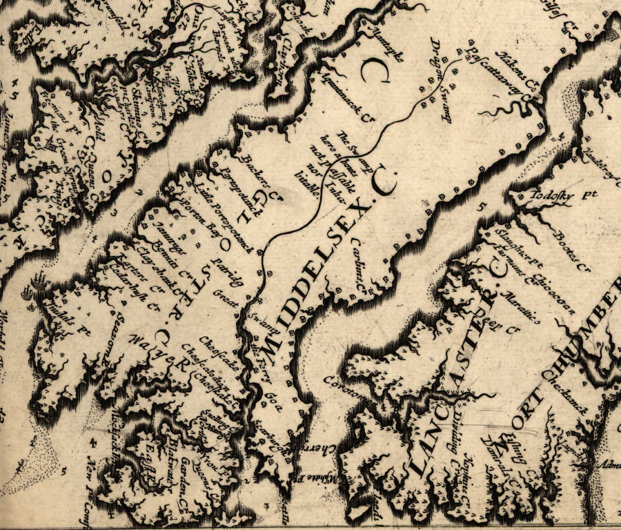
in the 1676 rebellion, Nathaniel Bacon followed the Pamunkeys into Dragon Run
(map is aligned so north is to the right, not towards the top)
Source: Library of Congress, Virginia and Maryland as it is planted and inhabited this present year 1670 by Augustin Herrman
Rivers and Watersheds
Virginia Places