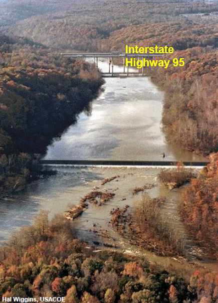
Embrey Dam, downstream of I-95 bridges across Rappahannock River, was blasted open in 2004
Source: US Fish and Wildlife Service, Dam Removal in Virginia: "Dammed If You Don't, Undammed If You Do"
Embrey Dam, downstream of I-95 bridges across Rappahannock River, was blasted open in 2004
Source: US Fish and Wildlife Service, Dam Removal in Virginia: "Dammed If You Don't, Undammed If You Do"
Construction of a transportation project on the Rappahannock River began in 1829.
The Rappahannock Company planned to construct 47 locks, 20 dams, and 15 miles of slackwater canal from the Fall Line at Fredericksburg upstream to Waterloo in Fauquier County. Construction was completed in 1849, 20 years later, with the completion of 25 stone locks, 55 wooden locks, plus the 20 dams and 15 miles of stone canals. The navigation system was designed to accommodate batteaux 65 feet long and 9.9 feet wide.
Within five years of completion, however, the Rappahannock Navigation Company was bankrupt, because operations and maintenance costs exceeded revenue from tolls. In the 1850's, traffic from the Piedmont region at the headwaters of the Rappahannock and Rapidan rivers, which could have floated downstream to Fredericksburg if the canal had been finished earlier, was carried instead by train on the Orange and Alexandria Railroad to the competing port at Alexandria.1
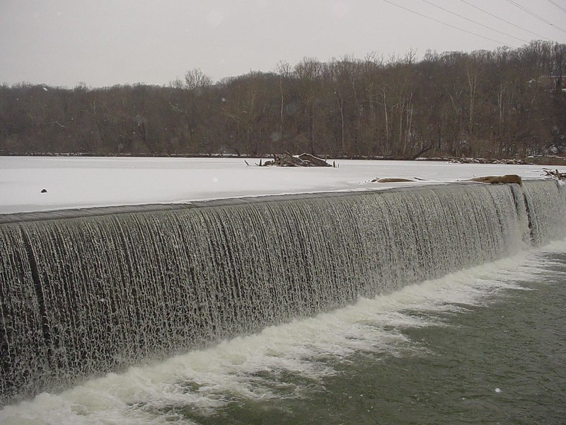
the 1855 dam diverted water into the Rappahannock Canal, which was used for hydropower in Fredericksburg
Source: Library of Congress, View of Fredericksburg, Va. Nov. 1862
The Fredericksburg Water Power Company purchased the Rappahannock Navigation Company rights on the Rappahannock and Rivanna River. The transportation rights were useless, but the power company wanted to use the transportation canal in Fredericksburg to distribute water to mills. The Fredericksburg Water Power Company built an 18' high dam at Fredericksburg in 1855, plus a canal through the countryside outside the town. Water from the canal, which was elevated above the river level, was released to turn waterwheels that powered machinery inside the mills on the southern bank of the Rappahannock River.
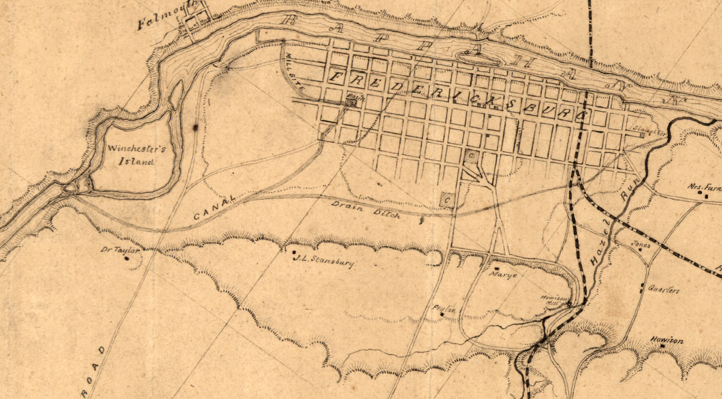
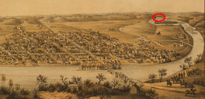
in December, 1862, the few crossings of the Rappahannock Canal ("Drain Ditch") forced Union troops to travel through narrow corridors before they could attack Marye's Heights, leading to an extraordinary slaughter by Confederate forces
Source: Library of Congress, Map of Fredericksburg, Va., and vicinity
The Fredericksburg Water Power Company became part of the Spotsylvania Water Power Company in 1910, one year after it had built a concrete dam 4' higher than the wooden 1855 dam. The extra height allowed the new 22' tall dam to supply 8,000 horsepower, compared to the 5,000 horsepower provided by the earlier dam. The Virginia Electric and Power Company (VEPCO) acquired the Spotsylvania Water Power Company and built a hydropower plant to generate electricity from the falling water.2
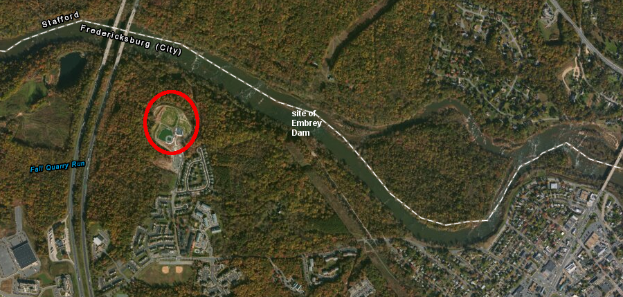
The City of Fredericksburg acquired the Embrey Dam from VEPCO in 1968, after the utility closed the small hydropower plant because it was relatively inefficient (especially compared to the utility's nuclear power plants). The city also acquired the utility's riparian land upstream of the dam, anticipating possible construction of the Salem Church Dam.
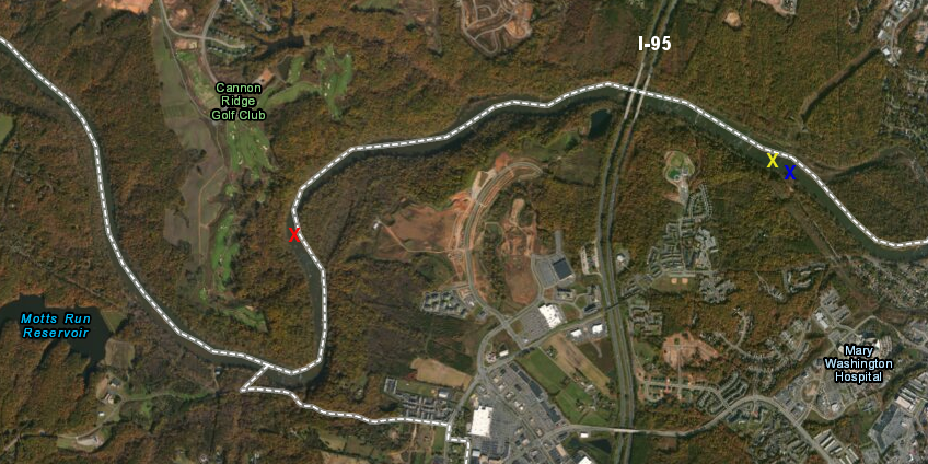
Embrey Dam (yellow X) would have been submerged by a re-regulating dam (blue X) for the Salem Church Dam (red X)
Map Source: ESRI, ArcGIS Online
The Salem Church Dam was authorized in 1946, at a maximum height of 220 feet above sea level, in response to the floods of 1942. The Corps of Engineers calculated the Salem Church Dam would have a positive 2.1-1 benefit/cost ratio, assuming benefits for flood control, water supply, lake recreation, and hydropower. Rural electric cooperatives supported the project, expecting to get priority to purchase hydropower from the Federal government at times of peak demand. The dominant investor-owned utility, Virginia Electric Power Company (VEPCO), opposed the project as unfair government-subsidized competition.
A smaller re-regulating dam would have been constructed just below the Embrey Dam to minimize the speed at which water levels changed downstream of Salem Church Dam. That re-regulating dam offered the opportunity to make Salem Church Dam into a pumped storage project, increase hydropower potential from 89MW to 200MW. Embrey Dam would have been submerged. A flat-water reservoir would have stretched 25 miles upstream to Kellys Ford on the Rappahannock and to Raccoon Ford on the Rapidan.3
Congress authorized a 20-foot taller Salem Church Dam in 1968. A reservoir at 240 feet above sea level would have flooded more of the river valleys upstream, but generated more hydropower and stockpiled a larger water supply. Opposition by canoeists and other advocates of free-flowing rivers, together with concerns about cost estimates and environmental impacts, prompted a revision in 1971 to build a dam at the 230-foot level and eliminate the hydropower. The Army Corps of Engineers finally determined in 1974 that the dam was not a feasible project, after recalculation of the interest rate dropped the benefit/cost ratio to 0.09.4
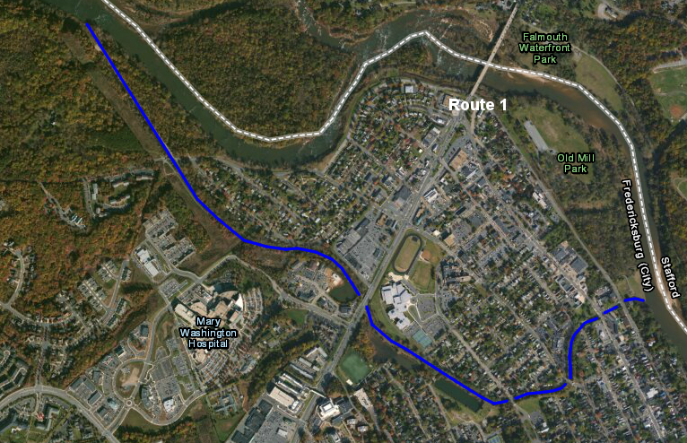
current location of historic canal used for waterpower in Fredericksburg
Source: US Fish and Wildlife Service, Wetlands Mapper
Until 1999, the city maintained the VEPCO canal that runs through Fredericksburg in order to bring water to the municipal water treatment plant. After the city partnered with Spotsylvania County to build a new water treatment plant upstream on Motts Run, Embrey Dam no longer provided any beneficial use.
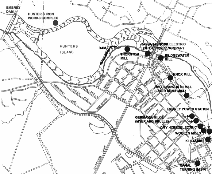
Embrey Dam diverted water to power numerous mills in Fredericksburg, and a separate canal further downstream powered a series of mills between Thornton's Mill and Knox Mill
Source: City of Fredericksburg, Historic Resources along the Rappahannock and Rapidan Rivers
The dam did create environmental harm. For almost a century, until 2004, the tall Embrey Dam blocked passage of anadromous fish such as American shad and striped bass. They could not spawn in the main stems of the Rappahannock and Rapidan and in tributaries to those rivers upstream of Fredericksburg. Fish could swim through the natural rapids at the Fall Line, but once the dam was constructed fish could not jump over a 22' high wall.
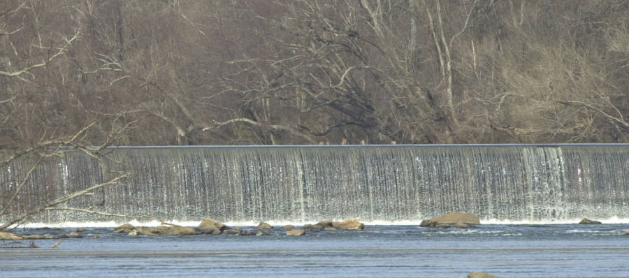
the 1910 version of Embrey Dam was 22 feet high, blocking shad from migrating upstream
Source: US Fish and Wildlife Service, National Digital Library
Recovery of native species is essential to restoring the health of the Chesapeake Bay. Estimates of suitable habitat blocked by the dam ranged from 100-900 miles, depending upon expectations of the size of small tributaries that would be used for breeding.5
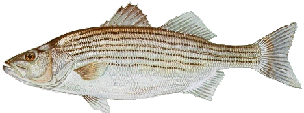
Striped bass
Source: US Fish and Wildlife Service, Image Library)
Fredericksburg found a creative way to get the dam removed at Federal, rather than local expense. It recruited the US military, under its Innovative Readiness Training program, to treat the dam removal as a training exercise. Thanks to the efforts of Senator John Warner, the US Congress provided $10 million to fund the dam removal. The initial blast to remove a section of the dam failed when only 10% of the charges exploded (it was a training exercise...), but the engineers quickly fixed the problem. A second blast breached the dam, and the remnants were removed by standard equipment after the spring fish migration season was over.6
Eight years later, scientists were delighted to discover that the project benefited more than shad and striped bass - there was a significant increase in breeding American eels in small streams at the headwaters in Shenandoah National Park.7
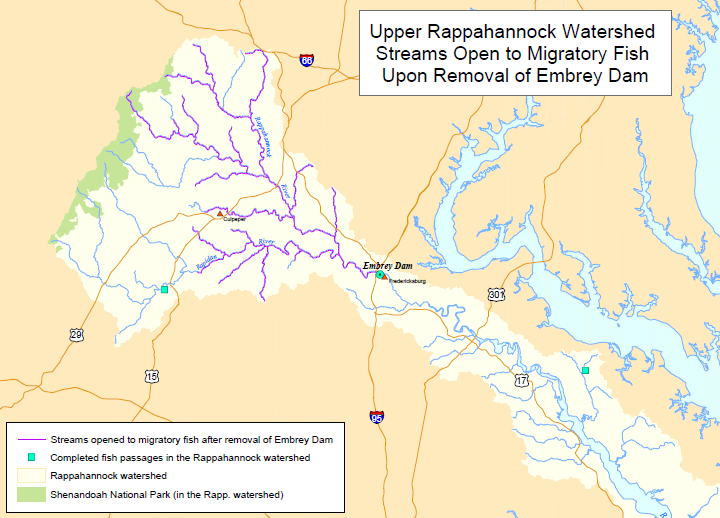
100 miles of habitat opened by removal of Embrey Dam (marked by purple lines on map)
Source: US Army Corps of Engineers Embrey Open Miles
One challenge from dam removal - what to do with the sediment that had been trapped by the dam? The dam was 22 feet high when first built, but by 1998 perhaps 500,000 cubic feet of sediment had accumulated. Water depth behind the dam was only 6-8 feet.8
There has been little industry in the Rappahannock River watershed upstream of Fredericksburg, so the level of toxic chemicals in the sediments was very low. They did not need to be handled as hazardous waste, but removing the dam and allowing a slug of sediments to wash downstream would have caused a substantial short-term impact on the aquatic vegetation and fish.
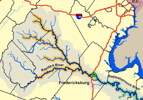
removal of Embrey Dam opened 106 miles of spawning habitat upstream on mainstem Rappahannock/Rapidan rivers
Source: Virginia Department of Game and Inland Fisheries, Embrey Dam Removal
The developer of the Celebrate Virginia project offered to use the sediments as fill material, reducing the cost of transport for the Corps of Engineers and increasing the amount of flat land that the real estate developer can create. The City of Fredericksburg finally purchased the 48-acre disposal site, so the city would own the valuable real estate that would be created.
Estimates of the volume of sediment ranged from 270,000 cubic feet to over 500,000 cubic feet. The Corps of Engineers decided to dredge about half for disposal on land, and ball fields were constructed later on top of that fill.
Embrey Dam in 2004
Source: US Army Corps of Engineers, Embrey (040220-A-0000A-003)
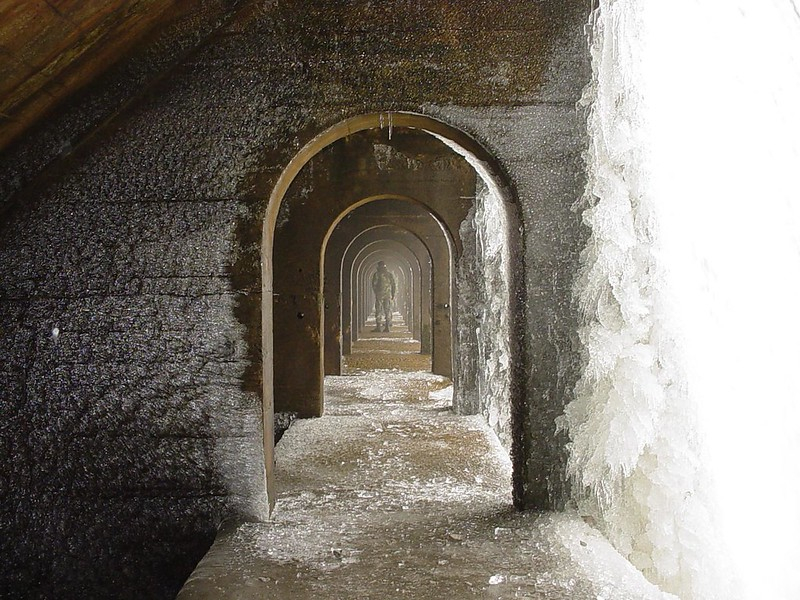
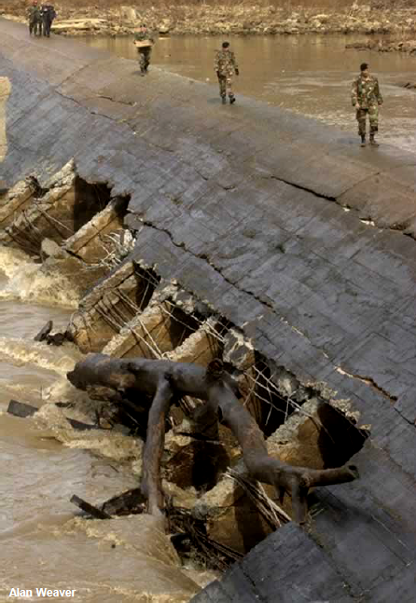
arches of the Embrey Dam, as a US Army diver examines the structure before removal
Source: US Army Corps of Engineers, 040220-A-0000A-005
The hard-to-access remainder was spread out in a thin sheet on the river bottom, left behind the dam for natural river flows to disperse downstream towards the Chesapeake Bay. In the end, the Corps was unable to dredge all the planned sediment before the deadline for dam removal, which had to occur before the springtime fish runs.9
sediment removed from behind Embrey Dam was deposited nearby and ballfields built on top of the fill
Source: ESRI, ArcGIS Online
As a result of incomplete removal or miscalculate volume, excess sediment plagued the Rappahannock River for years after removal of the Embrey Dam. In 2011, the chair of the local Economic Development Authority called for the Corps to return and complete the job. The presumed requirement was flood control, to remove the barrier of sediments still remaining in the Rappahannock River. The worst case scenario is another rainfall like October 1942, when the Rappahannock River rose past the 18' flood stage and crested at over 42' high.10
Embrey Dam was removed in 2004 at no cost to Fredericksburg, and the Corps even agreed to remove some of the remaining sediment at no expense to Fredericksburg. 11
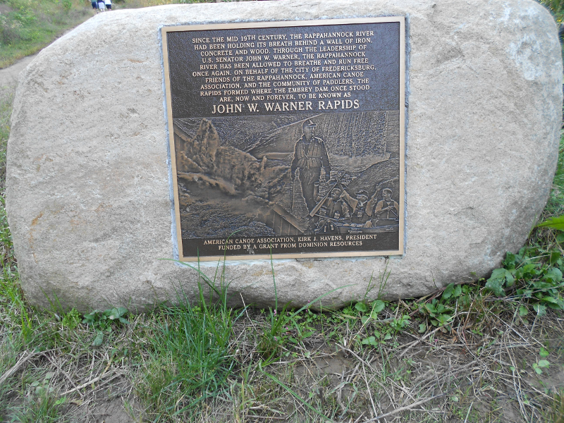
commemorative plaque at site of former Embrey Dam, honoring Senator John Warner for his support of efforts to remove Embrey Dam
One unsolicited proposal in 2012 proposed to dredge the silt and sell 1 million cubic yards as construction material. Though the individual making the proposal did not have experience in such projects and did not have any permits for such activities, the potential exists for re-purposing the silt rather than just wait for it to wash down to the Chesapeake Bay.. hopefully in a gradual fashion, without causing the city to flood.12
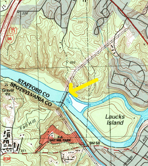
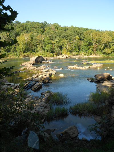
Rappahannock River, flowing free (now) between I-95 and old location of Embrey Dam (note I-95 in upper left)
Source: US Geological Survey (USGS), Fredericksburg 7.5 minute topo map (1994)
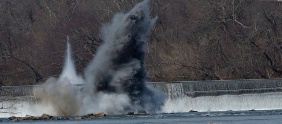
in 2004, the first attempt to blow up Embrey Dam failed
Source: US Fish and Wildlife Service, National Digital Library
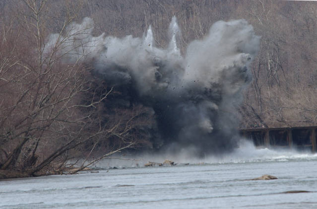
the second attempt to blow a hole in Embrey Dam was successful
Source: US Fish and Wildlife Service, National Digital Library