Which Way Do the Rivers Run?
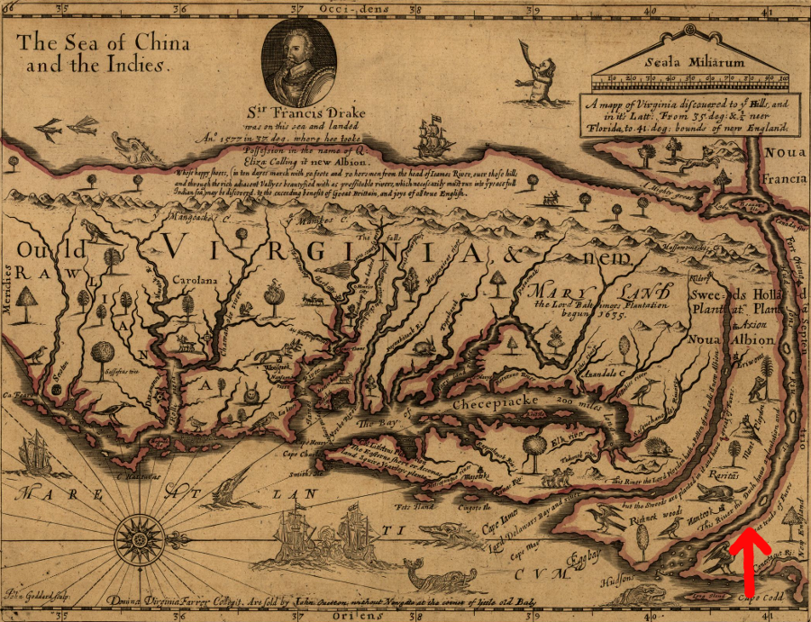
John Farrer's 1667 map showing presumed Northwest Passage (red arrow) to Pacific Ocean just west of the Blue Ridge Mountains
map is oriented with north to the right, and west at the top
Source: Library of Congress, A mapp of Virginia discovered to ye hills, and in it's latt. from 35 deg. & 1/2 neer Florida to 41 deg. bounds of New England
The instructions from the Virginia Company of London to the first English colonists who arrived in 1607 included a search for a passage to the Pacific Ocean, which the company called the "East India Sea." The investors hoped that the expedition would find a new access route for trade with the Spice Islands (now part of Indonesia) and China. Early explorers sought a passage through the North American continent that would allow trade with the Orient, while bypassing the Spanish in Central/South America
One possibility considered by those investors was that the continent of North America resembled Russia. Near Moscow, three rivers going in different directions facilitated trade between distant places. The Volga flowed southwest to the Caspian Sea, the Don flowed southeast to the Black Sea ("Euxine Sea"), and the Dvina flowed north to the White Sea ("Paelonian Sea") with access to the Arctic Ocean.
The instructions to the Jamestown colonists included the hope that:1
- you shall find some spring which run[s] the contrary way towards the East India Sea; for the great and famous rivers of Volga, Tan[a]is and Dwina have three heads near joynd; and yet the one falleth into the Caspian Sea, the other into the Euxine Sea, and the third into the Paelonian Sea
At that time, the English had no clue regarding the location of the continental divides separating the Atlantic Ocean and Gulf of Mexico, the Gulf of Mexico and Pacific Ocean, or the Gulf of Mexico and Hudson Bay. It took 150 years before explorers such as Gabriel Arthur, John Lederer, Thomas Batts, and William Fallam finally found rivers flowing westward towards the Mississippi River rather than eastward towards the Atlantic Ocean.
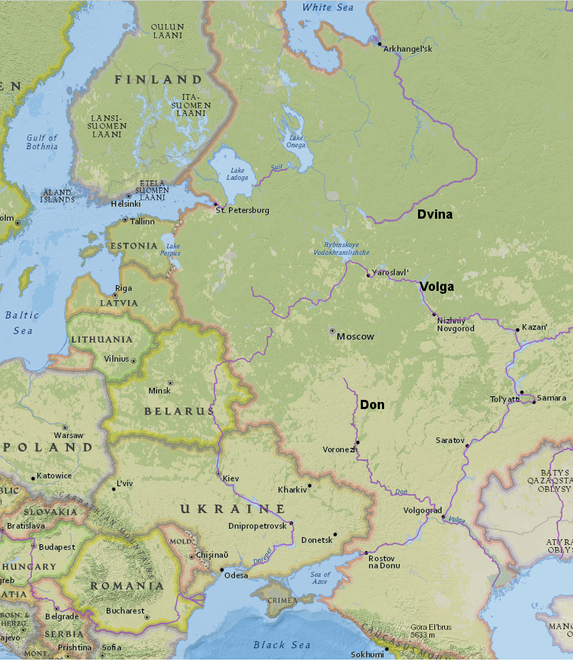
the London Company of Virginia hoped the 1607 colonists would discover rivers flowing west to the Pacific Ocean, similar to the way the Dvina, Volga, and Don rivers in Russia flowed from one central area to the Arctic Ocean, Caspian Sea, and Black Sea
Source: ESRI, ArcGIS Online
No part of Virginia is far from a creek, run, stream, or river. There are blue lines representing rivers on every page in Delorme's Virginia Map and Atlas - but how can a user of a printed atlas discover the direction that a river flows?
All rivers will flow down from the higher elevation to the lower elevation, but few maps include an arrow showing that a river flows east, or south, or whatever. A "planimetric" map of the rivers of Virginia will show only the horizontal features. Such a map will not show vertical topographic contour lines that could help determine the direction of flow.
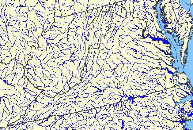
planimetric maps do not include elevation, so they do not reveal the direction in which rivers flow
Source: US Geological Survey (USGS), National Atlas
Water flows downhill due to gravity, obviously. Rivers always flow downhill, but "downhill" in the past may have been dramatically different than today. For example, some of the gaps in the Blue Ridge were probably carved by rivers that used to flow from western Virginia across the mountains to the Atlantic Ocean.
Millions of years ago, when the Shenandoah Valley was much higher in elevation, those ancient rivers carved out valleys where I-66, Route 50, and Route 7 now cross over the Blue Ridge. Later, the Shenandoah River "pirated" their waters. It eroded through limestone bedrock and carved a deep challen in the Shenandoah Valley faster than the other rivers etched away at the harder rock in the Blue Ridge. Waters that once flowed eastward across the Blue Rdge changed direction, leaving "wind gaps" in the mountains.
Similarly, the Potomac River once flowed over the current location of Tysons Corner before shifting to the north and carving the modern channel. Today Tysons Corner is one of the highest spots in Fairfax County; that is why water towers and telecommunications towers were built at the intersection of Route 123 and Route 7.
A few million years ago, the site of Tysons was surrounded by higher land. A river flowed (downhill...) through the site now covered with shopping malls and office buildings. When the Potomac River shifted directions and etched its modern valley elsewhere, the rounded river cobbles were left behind. Those hard cobbles slowed later erosion, the adjacent hillsides eroded faster, and the low river bottom became today's high ridgetop at Tysons.
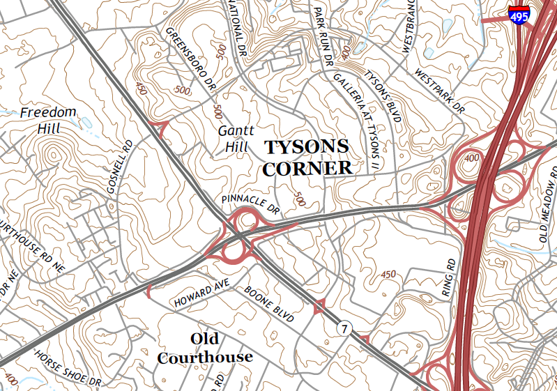
Tysons Corner, now a high spot in Fairfax County with elevation over 500 feet, was once the bottom of the Potomac River
(each brown contour line marks a 10' difference in elevation)
Source: US Geological Survey (USGS), Falls Church VA-MD 7.5 minute topographic quadrangle (2016)
The simplest way to determine the way the water goes is to look out the window when crossing a bridge, and observe the ripples and objects floating downstream in the river. Otherwise, to understand the flow pattern in an unfamiliar area, identifying the high ground is the best way to determine "down" and where rivers start/end.
The James River flows eastward through the Blue Ridge Mountains, past Richmond and on the Chesapeake Bay. For people who have just moved to Virginia, how do they determine whether the river flows west-to-east (from the Blue Ridge towards Richmond) or east-to-west (from Richmond towards West Virginia)?
On a map showing topographic contours, determine the elevation of two places along the river. The elevations marked on contour maps show that Glasgow (where the James River cuts through the Blue Ridge) is located on a flat flood plain 650' higher than Richmond:
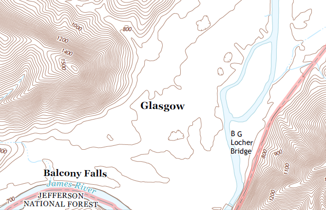
the James River at Glasgow (Rockbridge County) is roughly 700' above sea level
(elevation is marked in 20' contour intervals)
Source: US Geological Survey (USGS), Glasgow 7.5x7.5 topographic quadrangle (2013)
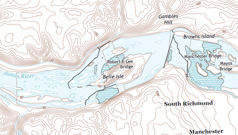
the James River in downtown Richmond is roughly 50' above sea level
Source: US Geological Survey (USGS), Richmond 7.5x7.5 topographic quadrangle (2013)
Water flows downhill, of course. The elevation difference between Glasgow and Richmond means the James River flows downhill from Glasgow towards Richmond, from the west towards the east. Follow the line of the river on the map towards the east, downstream of Richmond, and it s obvious that the water in the James River will flow into the Chesapeake Bay and then reach the Atlantic Ocean.
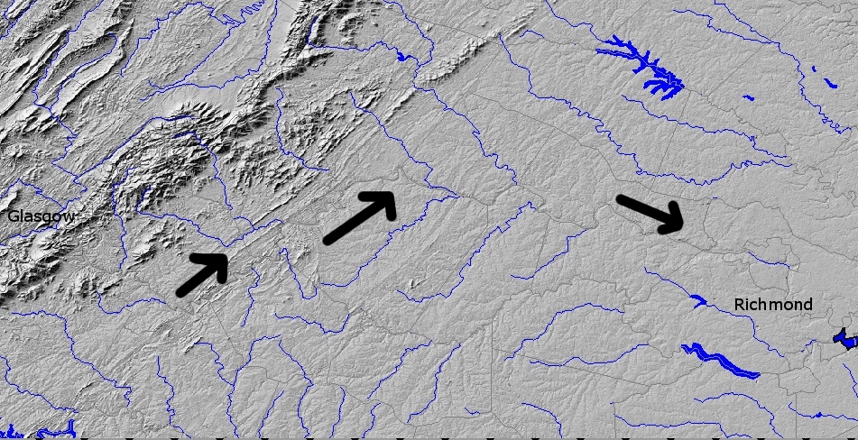
topography of Virginia between Glasgow-Richmond
Source: USGS National Map Seamless Server
Virginia's rivers do not run due east, straight from the mountains to the Atlantic Ocean. Some run north, others flow west or south. All change direction often.
The changes in direction reflect changes in bedrock in different physiographic provinces and at specific locations. Bedrock varies in its resistance to the power of the water to erode a channel, a characteristic displayed most obviously at waterfalls. Rivers shift direction slightly from time to time as they expend their mechanical energy and flow downhill under the influence of gravity to the Atlantic Ocean.
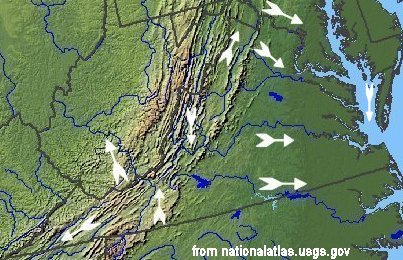
river directions in Virginia
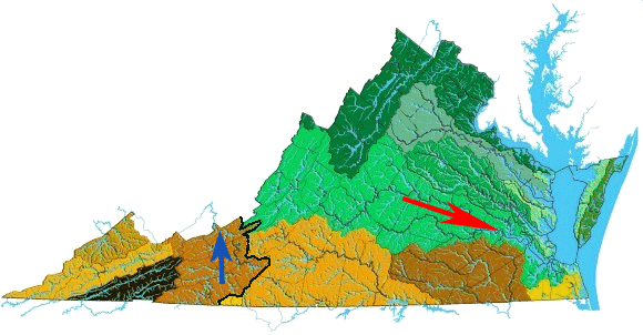
Computerized processing of digital elevation model (DEM) data illustrates the location of rivers in relation to hills and valleys, without the confusing details of roads and houses that clutter up the view in satellite images.

Virginia topography
Source: US Geological Survey Open-File Report 99-11, Color Shaded Relief Map of the Conterminous United States
 Before reviewing in more detail the three sections highlighted on that map, orient yourself.
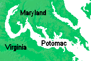
North is at the top of the map, according to modern tradition. On the right (east) side of the map, the Chesapeake Bay and the main stems of the Tidewater rivers are white.
The lower elevations are dark green, the higher elevations are lighter shades of green, and the highest elevations (such as the Blue Ridge) are colored in shades of brown. Note that in the color scheme of this particular map, dark brown corresponds to the highest elevations while dark green corresponds to the lowest elevations.
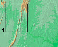
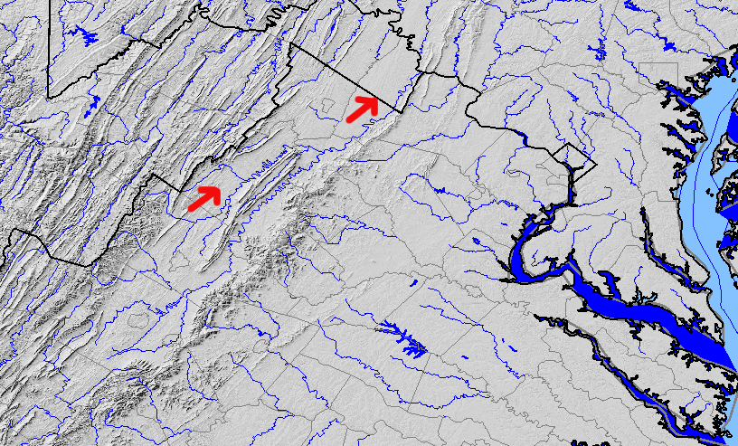
Box 1 (above) includes the water gap carved through the Blue Ridge at Harpers Ferry by the Potomac River.
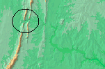
The circled area on the right offers a close-up. The Potomac River has eroded a wide swath though the soft limestone of the Great Valley west of the Blue Ridge, but has carved only a narrow channel as it cuts through the harder igneous bedrock of the mountains.
The darker green squiggle to the right of Harper's Ferry is the path of the Potomac River. The variations of color illustrating the topography show where it flows from its headwaters in the Appalachians towards the river mouth. There the Potomac River disappears as a river, based on how humans have distinguished "river vs. "bay," and the water flows into the Chesapeake Bay.
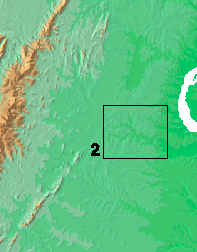
Box 2 shows that junction of the Rappahannock and the Rapidan rivers.
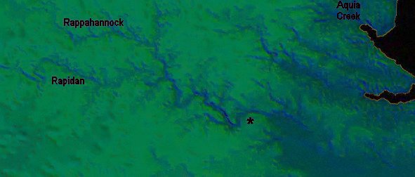
The asterisk notes the location of Fredericksburg. Viewing different DEM's and the DeLorme Atlas and Gazetteer can help reveal the channels of Potomac Creek and Accokeek Creek between Aquia Creek and the Rappahannock River, and whether the I-95 bridge over the Rappahannock is to the east or west of that asterisk.
James River channel
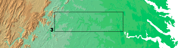
 Box 3 on the "Color Shaded Relief Map of the Conterminous United States" (above) shows the channel of the James River through the Piedmont, from the Blue Ridge to the Fall Line. The color scheme communicates that the higher elevation is in the west, so the James River is flowing to the east. Where Dunlap Creek flows into Jackson's River (now Covington, Virginia) was known as the "head of navigation" for batteaux floating goods down the James River.2
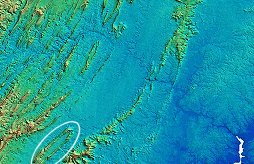
Once the river channel is recognizable on a DEM, how can one tell the direction of flow? On the DEM's, there is a clear color difference between the area with the highest and lowest elevations.
On the image to the right, the channel of the Potomac River is a distinctly darker blue. The higher elevations at Massanutten Mountain (circled in white) are tan. Colors are not standardized and will vary on computerized maps from alternate sources, but the color differences will always highlight the elevation differences.
The rivers will always flow downhill, of course. East of the Blue Ridge in Virginia, downhill always will be towards the southeast and the Atlantic Ocean. West of the Blue Ridge, and south of Roanoke, some Virginia rivers flow west to the Mississippi River and the Gulf of Mexico.
The Coastal Plain is relatively flat compared to the Piedmont, Blue Ridge, Valley and Ridge, or Appalachian Plateau physiographic provinces, so the topography of the southeastern rivers is harder to see with DEM's. The Nansemond River runs through the city of Suffolk. It drops only 20 meters in elevation from the headwaters to the mouth, where it empties into the James River at Hampton Roads.
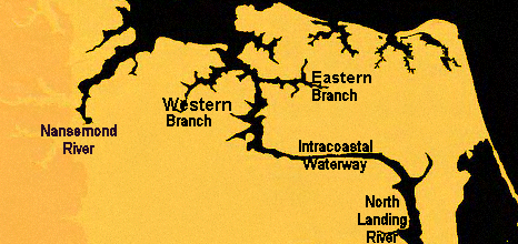
The Western Branch and Eastern Branch of the Elizabeth River are obviously flowing towards Hampton Roads. The Southern Branch is connected to the North Landing River by the Intracoastal Waterway. (Back Bay - and the barrier island separating it from the Atlantic Ocean, the location of False Cape State Park - are nearby at the southeast corner of Virginia.)
In Richmond, the James River and Kanawha Canal had to blast through granite just west of downtown, almost bankrupting the company because of the costs and delays. In southeastern Virginia, it was relatively easy to dig a canal connecting the Albemarle Sound to the Chesapeake Bay, since the sediments were soft, unconsolidated sand and mud. They even built two - the Dismal Swamp Canal paralleled by Route 17 in the City of Chesapeake was constructed first, and it's still in operation as another segment of the Intracoastal Waterway.
 West of the Blue Ridge, rivers might flow to the Gulf of Mexico. Two forks of the Shenandoah River flows northeast from either side of Massanutten Mountain (in the white ellipse) to the Potomac River. The North Fork of the Shenandoah River flows on the northwest side of Massanutten Mountain, and the south fork flows between the mountain and the Blue Ridge. They both flow northeast, meandering back and forth in the process, and join at Front Royal at the northeastern tip of Massanutten Mountain
The channel of the Shenandoah River may not be obvious on small-scale images. Refer to the contour lines in the Virginia Atlas and Gazetteer that show elevation, and use them to distinguish "up" and "down." There's no arrow in the Atlas for identifying the direction of flow of the Shenandoah River, but you know it's going downhill.
In southwestern Virginia, most rivers flow south (Holston River, Clinch River, Powell River) or west (Levisa Fork, New River) towards the Ohio River, then on into the Mississippi and the Gulf of Mexico. The Shenandoah River flows north, just like the Nile River in Egypt.
North Fork of Shenandoah River, flowing north from Harrisonburg towards Harpers Ferry in West Virginia
(Source: USGS National Map Seamless Server)
If you always thought north was "up the map" because that's the way the maps hung on the wall in elementary school - well, don't be confused and think north is "uphill." Staunton and Waynesboro are located at the southern, upper end of the Shenandoah Valley. The Shenandoah River flows north to Harpers Ferry, flowing downhill the entire time it flows north.
Don't say the Shenandoah River flows "up" to Harpers Ferry, unless you can repeal the law of gravity. When you go upstream on the Shenandoah River, you are going southwest. When you go from Harpers Ferry to Harrisonburg or Staunton, you are going "up the Valley" - at least technically.
The mountain ranges (or low hills) that define the edge of a watershed are watershed divides, where the rain divides to flow in one direction or another from the top of the hill towards the bottom. All of Virginia is east of the Continental Divide in Colorado, which splits water so some raindrops flow to the Pacific Ocean and other raindrops flow to the Gulf of Mexico.
There is an Eastern Continental Divide in southwestern Virginia, similar to that more-famous Continental Divide in the Rocky Mountains out west. On one side of the Eastern Continental Divide, Virginia rivers flow to the Atlantic Ocean. On the other side of the divide, the rivers flow to the Gulf of Mexico.
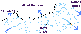
the James River flows southeast to the Chesapeake Bay (red arrow) while the New River flows north and west to the Mississippi River/Gulf of Mexico (blue arrow), and the watershed boundaries define the Eastern Continental Divide (black line)
Source: Virginia Department of Conservation and Recreation
Stormwater Management
Drop a stick into the South Fork of the Shenandoah River near Luray, and the stick will float down the Shenandoah River to Harpers Ferry, then east down the Potomac River to the Chesapeake Bay, then south through the bay past Cape Charles/Cape Henry into the Atlantic Ocean.
In contrast, for most of its journey in Virginia the New River moves north and west. Swimmers occasionally lose control over their inner tube, or drop a beer can, in the New River at McCoy Falls near Virginia Tech at Blacksburg. If not retrieved, those objects will float westward through West Virginia, down the Mississippi River, past New Orleans to the Gulf of Mexico. They will never come close to the Chesapeake Bay, because the New River is on the other side of the Eastern Continental Divide.
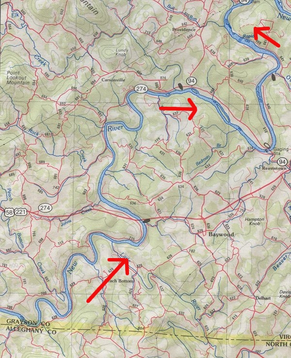
New River, winding its way north from the North Carolina border through Grayson County in Virginia, on towards
Virginia Tech in Blacksburg... and then into West Virginia to the Ohio River
Watershed divides are like the ridgeline at the top of a house's roof. Raindrops that hit the roof on the eastern side on the Eastern Continental Divide - such as in Roanoke, Staunton, or Charlottesville - will flow to the Atlantic Ocean. Raindrops landing on the western side - such as in Norton, Abingdon, or Radford - will flow to the Mississippi River and the Gulf of Mexico.
The ultimate destination makes a big difference, in regard to management of pollution in the waters. Regulations to save the Chesapeake Bay have resulted in stricter controls on nitrogen, phosphorous, and sediment in waterways that flow to the Chesapeake Bay.
NOTE: There are multiple continental divides in North America. The most-famous "Continental Divide" is marked by the Rocky Mountains, separating the Gulf of Mexico watershed from the Pacific Ocean watershed. The Northern Continental Divide runs just north of the Great Lakes/St. Lawrence River in Canada, separating the Arctic Ocean/Hudson Bay from the other watersheds to the south.
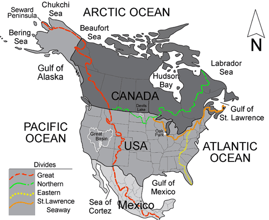
the Eastern Continental Divide separates rivers flowing to Atlantic Ocean vs. Gulf of Mexico, while the Northern Continental Divide separates the Arctic Ocean from other water bodies
Source: US Geological Survey (USGS), Continental Divides in North Dakota and North America
Links
- River Runner (where a raindrop falling anywhere in the world ends up)
- US Geological Survey (USGS)
References
1. "Instructions for the Virginia Colony," Virginia Company of London, 1606, posted online by S. Mintz, S. McNeil, Digital History, http://www.digitalhistory.uh.edu/disp_textbook.cfm?smtID=3&psid=3993 (last checked December 18, 2015)
2. Gertrude Lacy, "A Walking Tour of Old Covington," http://freepages.history.rootsweb.ancestry.com/~alleghanyhighlands/localpic/towntour.htm (last checked August 28, 2011)
Rivers and Watersheds
Virginia Places
