the Shenandoah River watershed extends south into Nelson County
Source: US Geological Survey (USGS), Streamer
the Shenandoah River watershed extends south into Nelson County
Source: US Geological Survey (USGS), Streamer
The source of the North Fork of the Shenandoah River was designated officially in 1989 by the US Forest Service and the Friends of the North Fork. They chose Sand Spring in Rockingham County at the headwaters.1
major tributaries and main stem of the North Fork of the Shenandoah River
Source: US Geological Survey (USGS), Streamer
major tributaries and main stem of the South Fork of the Shenandoah River
Source: US Geological Survey (USGS), Streamer
The Shenandoah River has been memorialized in multiple songs. "Take Me Home, Country Roads" describes it as a West Virginia river, but only the lower 20 miles were in that state. The songwriters wrote the first lyrics while traveling on Clopper Road in Maryland. Rhymes with "Maryland" escaped them, and after exploring other states they settled on West Virginia. Neither of the songwriters had ever been in the state, but they had driven down I-81 to Roanoke. Mistakenly, they thought the land west of the highway was part of West Virginia and incorporated that state into a song soon made famous by John Denver.2
Peter Jefferson's 1747 map of the Fairfax Grant noted the forks of the Shenandoah River, on either side of Massanutten Mountain ("Peeked Ridge")
Source: University of North Carolina, "Early Maps of the American South," A Map of the northern neck in Virginia (by Peter Jefferson, Robert Brooke, Benjamin Winslow, Thomas Lewis, 1747)
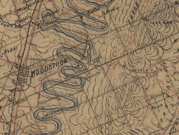
meanders of the South Fork, Shenandoah River
Source: Jedediah Hotchkiss's map of the valley, 1862
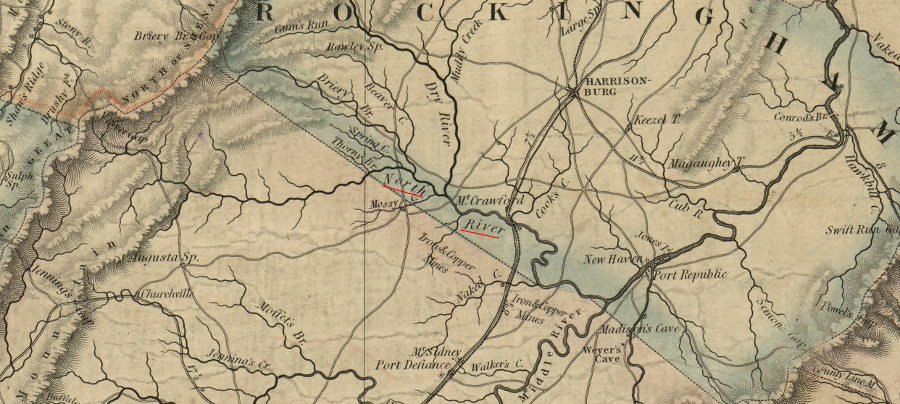
the North River, with its headwaters west of Harrisonburg, does not flow into the North Fork of the Shenandoah River - Harrisonburg is on the wastershed divide, and the North River merges with the Middle and South rivers near Port Republic to form the South Fork of the Shenandoah River
Source: Library of Congress, A map of the state of Virginia, constructed in conformity to law from the late surveys authorized by the legislature and other original and authentic documents
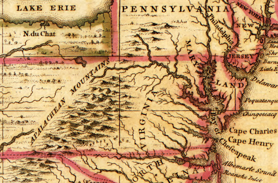
settlers understood the forks of the Shenandoah River before mapmakers represented them accurately
Source: Library of Congress, A map of the British Empire in America with the French and Spanish settlements adjacent thereto (Henry Popple, 1733)
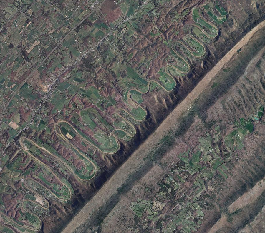
the Shenandoah River bends reflect underlying fractures in the bedrock, which create zones of weakness susceptible to erosion
Source: Virginia Geographic Information Network (VGIN), VBMP 2011 WGS Web Mercator (VGIN)
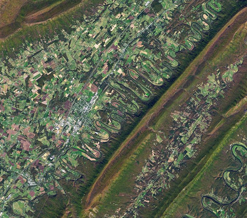
the bends of the North Fork of Shenandoah River south (upstream) of Strasburg - and in the South Fork of the Shenandoah River on the other side of Massanutten Mountain - are reflections of the fracture patterns in the underlying limestone bedrock
Source: National Aeronautics and Space Administration (NASA), Earth Observatory, The Sinuous Shenandoah
1. "Monument Marks the Start of the North Fork of the Shenandoah River," Friends of the North Fork of the Shenandoah River, http://www.fnfsr.org (last checked May 16, 2014)
2. Lori Wysong, "Maryland was almost 'Almost Heaven'," Boundary Stones Blog, WETA, July 18, 2019, https://boundarystones.weta.org/2019/07/18/maryland-was-almost-almost-heaven (last checked July 21, 2020)