
the Richmond and Alleghany Railroad built on the towpath of the James River and Kanawha Canal
Source: US Geological Survey (USGS), Buckingham, VA 1:125,000 topographic quadrangle (1892)
the Richmond and Alleghany Railroad built on the towpath of the James River and Kanawha Canal
Source: US Geological Survey (USGS), Buckingham, VA 1:125,000 topographic quadrangle (1892)

the Richmond and Alleghany Railroad tracks paralleled the James River, offering a water level route through the Blue Ridge to Richmond
Source: US Geological Survey (USGS), Palmyra VA 1:125,000 topographic quadrangle (1891)
The Richmond & Alleghany Railroad was chartered in 1878 and started operations in 1881. It laid track on the relatively flat tow-path of the defunct James River and Kanawha Canal, replacing mule-drawn boats with trains. The canal's route offered the most gentle grade west from Richmond through the Blue Ridge to Clifton Forge.
The Virginia Central, Southside, and Virginia and Tennessee railroads plus the James River and Kanawha Canal brought freight traffic to the port of Richmond before the Civil War. As the benefits of trains over canal boats became clear, the Richmond and Lynchburg Railroad was chartered in 1860 to build track from the state capital up the James River valley. That opportunity disappeared with the Civil War.
In 1873, potential investors got the General Assembly to charter the Straight-Shoot Railroad. The Chesapeake and Ohio Railroad, which included the former Virginia Central, had already built track west of Covington and was bringing West Virginia coal to Richmond.
In 1878, the legislature amended the Straight-Shoot Railroad charter and renamed the company the Richmond & Alleghany Railroad. The charter included a requirement to build a branch to Lexington.
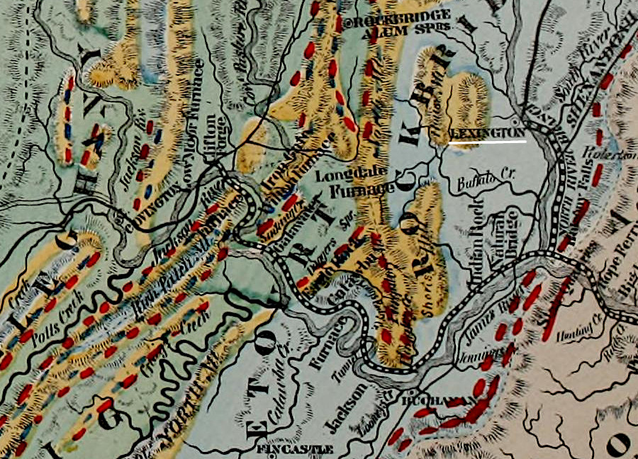
the General Assembly required the Richmond and Alleghany Railroad to build a branch to Lexington
Source: John Lyle Cambell, Geology and mineral resources of the James River Valley, Virginia, U.S.A. (1882)
In 1880 the Richmond & Alleghany Railroad acquired all the rights and property of the James River and Kanawha Canal, including the docks and turning basin in Richmond. The purchase also included the Buchanan and Clifton Forge Railway, which was building track from the canal's end at Buchanan to link up with the Chesapeake and Ohio Railroad at Clifton Forge. The acquisition included a requirement to drain the canal so there would not be pools of stagnant water.
The 250 miles of track were laid by crews working in two directions. The men building the railroad eastward from Clifton Forge went 84 miles to Lynchburg. Crews working westward from Richmond built 146 miles of track to Lynchburg. The line between Richmond-Clifton Forge was useable by September 1881, and the Lexington Branch was completed a month later.

the Richmond and Alleghany Railroad was built from Richmond westward, reaching Bremo Bluff after Columbia
Source: John Lyle Cambell, Geology and mineral resources of the James River Valley, Virginia, U.S.A. (1882); New York Public Library, Half of an unidentified map showing the southeastern part of Virginia and the northeastern part of North Carolina (1870-79)
Almost all the rails were laid on the towpath between Richmond and Lynchburg. Later, track was relocated to straighten out a few bends. A new railbed was constructed from Clifton Forge to Lynchburg because the towpath had so many tight curves.
![]()

the Richmond and Alleghany Railroad laid track on the old towpath of the James River and Kanawha Canal
Source: Lynchburg Museum, Boating on the James River & Kanawha Canal; Baist Atlas of Richmond, VA, 07_Part of Jefferson Ward Richmond (1889)
In Lynchburg, the Norfolk and Western and the Virginia Midland railroads were unwilling to let the competitor cross their tracks. The Richmond & Alleghany Railroad ended up building its track in a deeep trench, using the bed of the canal, to pass underneath them. The sunken track lasted until agreements were reached in 1887.
Roundhouses were built at Iron Gate in the western end and in Richmond. Along the canal's path through the capital city, the Richmond & Alleghany Railroad constructed a wooden trestle from 10th to 19th street, with an iron bridge to cross over the tracks of the Richmond and Danville Railroad.
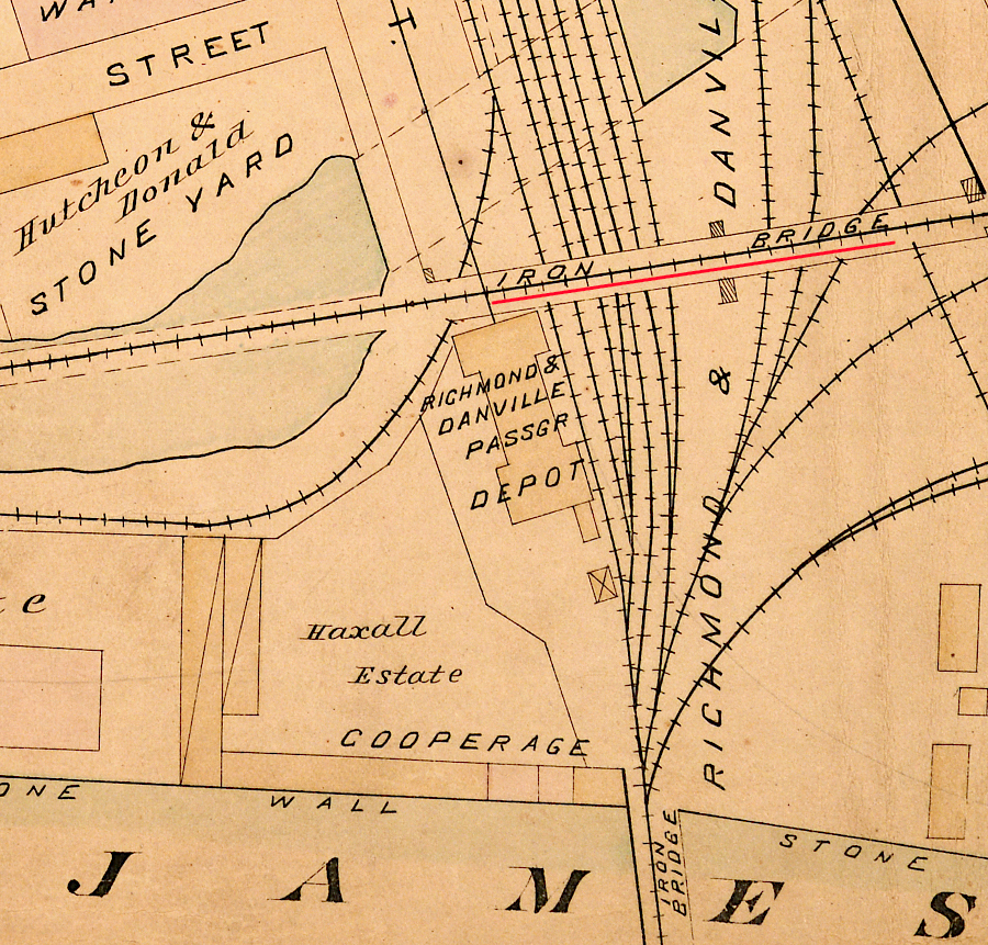
in Richmond, the Richmond and Alleghany Railroad built a bridge to cross the former turning basin and the tracks of the Richmond and Danville Railroad
Source: Baist Atlas of Richmond, VA, 07_Part of Jefferson Ward Richmond (1889)
The Richmond & Alleghany Railroad partnered with other investors to propose the Richmond, Alleghany and Ohio Central Railroad. It would construct track west from Eagle Rock, going southwest up Craig Creek and through a tunnel to cross the Eastern Continental Divide into the New River watershed at Sinking Creek.
The Richmond & Alleghany Railroad went into bankruptcy in 1883 during a financial crisis (the Panic of 1893) that led to an economic depression. After reorganization, it was auctioned off in 1889. The Chesapeake and Ohio (C&O) Railway operated the Richmond & Alleghany Railway until it absorbed the line in 1890.
The Richmond & Alleghany Railroad route along the old canal towpath between Clifton Forge to Richmond was 38 miles longer that the Chesapeake and Ohio Railroad. However, the grade was much more gentle, reducing the burden on locomotives to pull freight uphill. In particular, the Richmond & Alleghany Railroad route went through the Blue Ridge at Balcony Falls at 725 feet in elevation. The Chesapeake and Ohio (C&O) Railway route climbed to 1,520 feet in order to pass through the Blue Ridge Tunnel.1
The Chesapeake and Ohio Railroad and then CSX shipped trains loaded with coal eastward to Newport News using the James River route. To reduce congestion, trains with empty coal cars returned to West Virginia via the original Virginia Central route using the Blue Ridge tunnel.
CSX leased the original Virginia Central route to the Buckingham Branch Railroad in 2004. It named that section, with 200 miles of track between Richmond and Clifton Forge, the Richmond & Alleghany Division.2

the Richmond and Alleghany Railroad freight depot was next to the canal's former turning basin in downtown Richmond
Source: Virginia Commonwealth University, Baist Atlas of Richmond - Outline & index map Richmond and vicinity (1899)

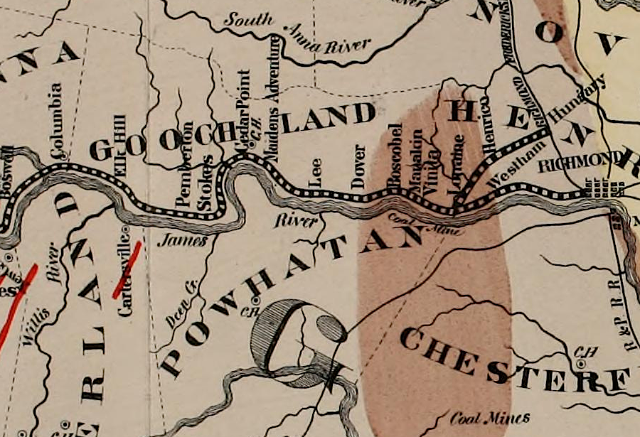
the Richmond and Alleghany Railroad built track on the towpath of the canal branch to Lexington (yellow), as well as the James River (red)
Source: David Rumsey Historical Map Collection, Virginia and West Virginia (The National Atlas Containing Elaborate Topographical Maps Of The United States And The Dominion of Canada, by O. W. Gray, 1877)