until Virginia ceded its claims to western lands, the state claimed its boundaries extended beyond Lake Michigan
Source: William Robertson Garrett, History of the South Carolina Cession, and the Northern Boundary of Tennessee
until Virginia ceded its claims to western lands, the state claimed its boundaries extended beyond Lake Michigan
Source: William Robertson Garrett, History of the South Carolina Cession, and the Northern Boundary of Tennessee
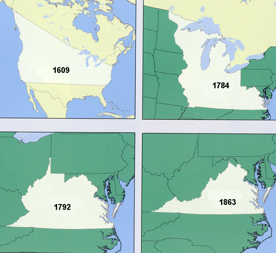
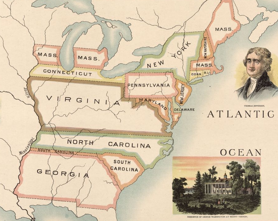
Virginia reached its greatest extent in 1609, when King James I issued a second charter to the Virginia Company of London that defined new boundaries for the Virginia colony. The new claims extended north to what is now Maine, south to near the modern North-South Carolina border, and "from sea to sea, west and northwest" all the way to the Pacific Ocean.
Virginia's claims to the Northwest Territory were based on that charter, reaffirmed by military conquest of Kaskaskia and Vincennes during the American Revolution. The territory west of the Mississippi River remained largely unknown until the Lewis and Clark expedition in 1803-1805, so in the 1700's Virginia focused on its claims east of that river.
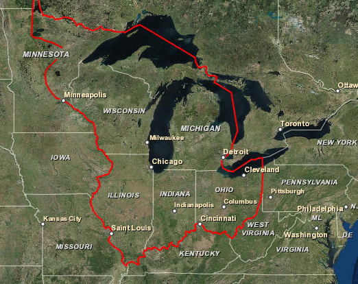
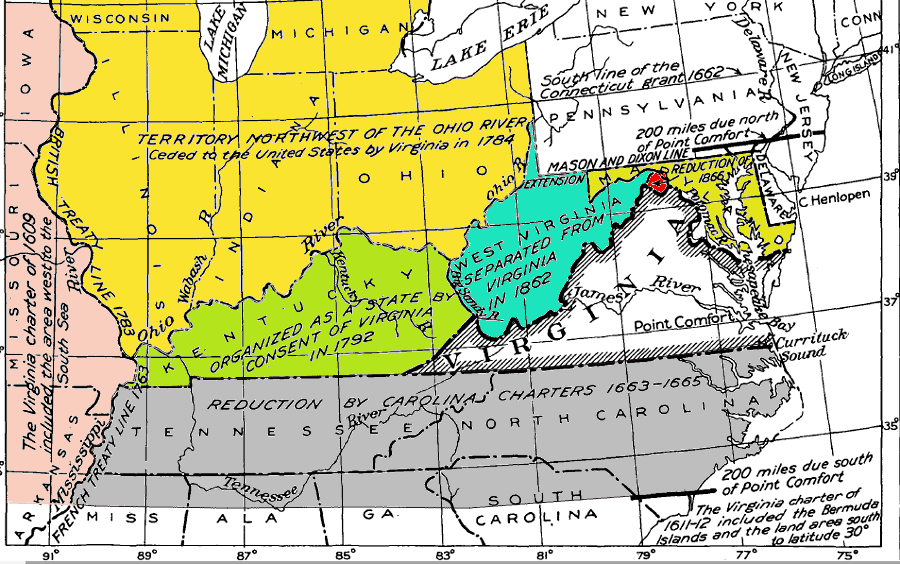
The claim to lands east of the Mississippi River were upheld by colonial and then state officials for over 170 years until the state agreed to transfer the Northwest Territory to the national government in 1781, a cession finally completed in 1784. That land transfer reduced Virginia's territorial claim extending to the Mississippi River by over 360,000 square miles, from 469,000 square miles down to 107,413 square miles. Today, after the subsequent creation of Kentucky and West Virginia, the boundaries of Virginia emcompass 42,775 square miles of land and water.
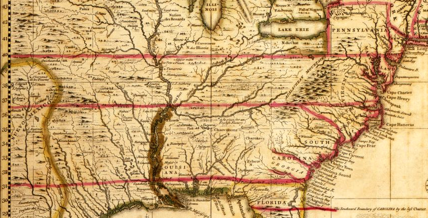
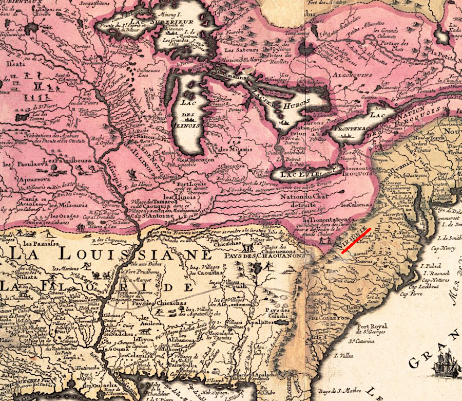
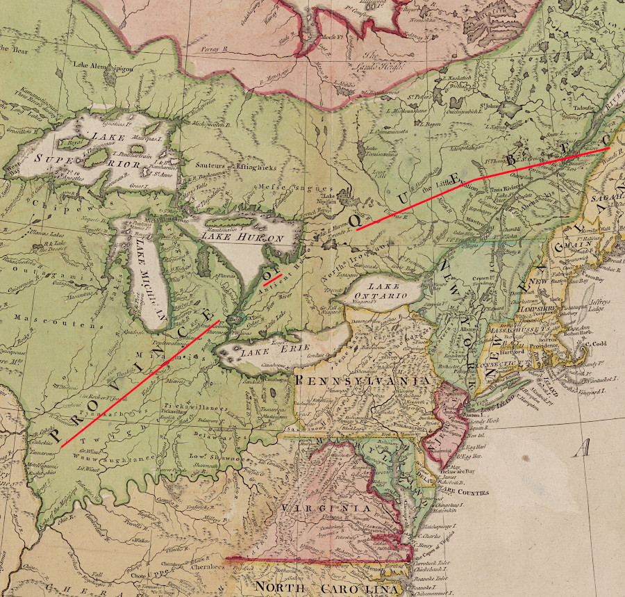
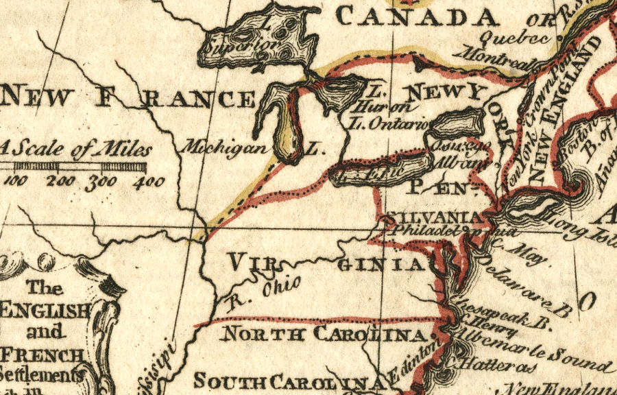
Virginia's claims to western lands under the 1609 charter were interpreted by Henry Popple in 1743 to follow the 36° 30' and 40° lines of latitude
Source: Library of Congress, A map of the British Empire in America with the French and Spanish settlements adjacent thereto (by Henry Popple, 1743)
A third charter issued by King James I in 1612 retained Virginia's rights to "all that Space and Circuit of Land lying from the Sea Coast of the Precinct aforesaid, up into the Land throughout from Sea to Sea West and North-west," plus it expanded the colony's boundaries eastward to include the recently-discovered island of Bermuda.
Virginia has been reduced in size in various ways since 1612. The Virginia Company spun off Bermuda in 1615, when the Bermuda Company obtained a separate charter from King James I for the Plantation of the Somers Isles.1
In 1624, after the Virginia Company had failed to produce a profit and the 1622 uprising demonstrated the company's inability to even defend the colony, King Charles I revoked the 1612 charter. The conversion of Virginia from a private business into a royal colony altered the basis for government, but the king did not alter any of Virginia's boundaries in 1624.
Despite subsequent legal confusion over the validity of outdated charters - and perhaps in part because of it - Virginia officials have cited the boundaries in the 1609 charter whenever there was an opportunity to assert control over western lands that are today part of western Pennsylvania, Ohio, Indiana, Illinois, Michigan, and Wisconsin.
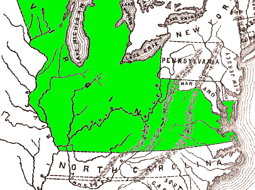
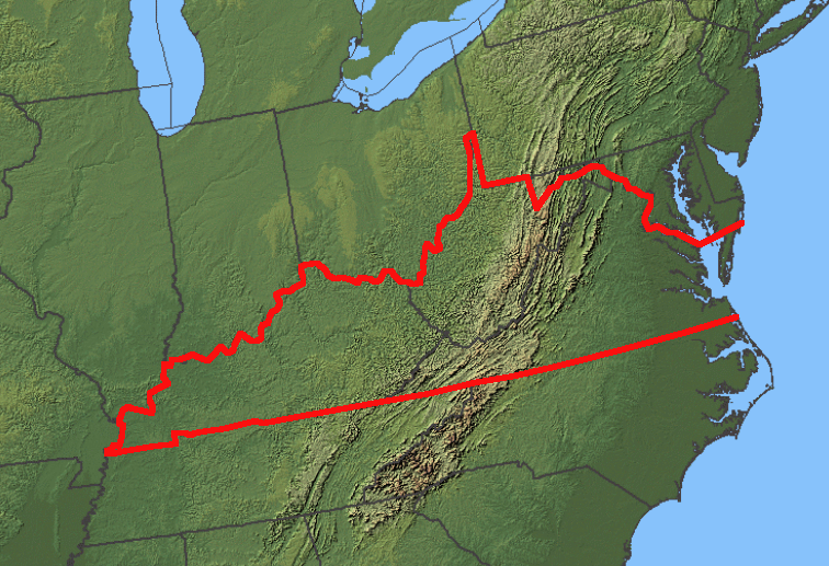
Virginia's land claims shrank from the 1609 Second Charter grant "from sea to sea, west and northwest" until the formation of the State of West Virginia in 1863
Source: Virginia Geographic Alliance, Virginia Land Claims (derived from Map 28 in "An Atlas of Virginia")
What the king granted to a few well-connected friends in the Virginia Company, the king could take away. The boundaries of the colony were modified by various actions of the king, from the creation of Massachusetts in 1620, Maryland in 1632, and adjustment of the North Carolina border in 1665 through the Quebec Act of 1774.
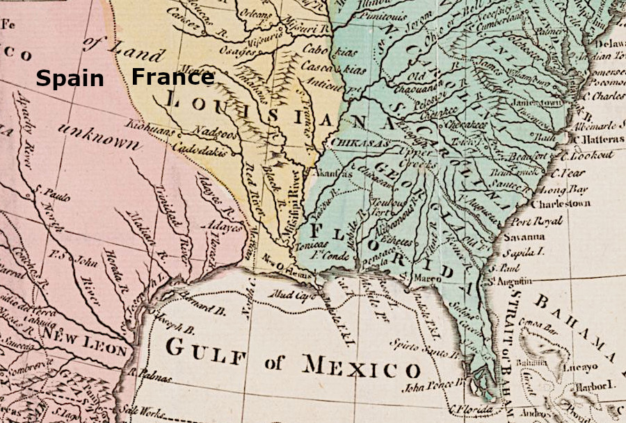
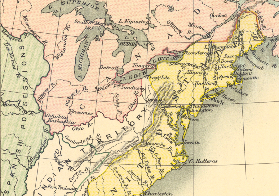
In Article VII of the 1763 Treaty of Paris, France and Great Britain established the middle of the Mississippi River as the western edge of British-controlled territory. That treaty ended Virginia's "from sea to sea" colonial claim to reach the Pacific Ocean. West of the Mississippi River, French-controlled Louisiana extended to a boundary along the Rocky Mountains with Spanish-controlled Mexico.
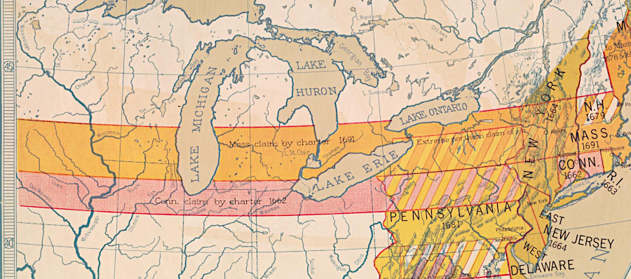
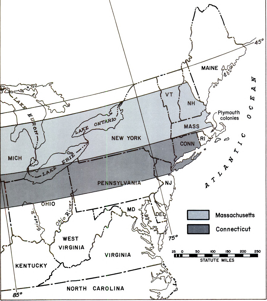
Massachusetts and Connecticut cited their colonial charters, when they claimed lands north of the Ohio River within the boundaries of Virginia's 1609 charter
Source: Library of Congress, English colonial grants (Hart-Bolton American history maps, 1917); Bureau of Land Management, A History of the Rectangular Survey System: Volume 2 (Figure 2)
Once Virginia became an independent state, its western boundary was minimized first by a land cession of the territory past the Ohio River to the Confederation Congress. However, the nascent national government did not accept the land until 1784, after negotiating changes in restrictions that had accompanied the voluntary cession.
France and Spain did not acknowledge Virginia's claims beyond the Mississippi River, or even the Alleghenies
Source: New York Public Library, Carte de la Nouvelle Frances (1732?)
the 1783 Peace of Paris defined the Mississippi River as the western boundary of the United States, ending Virginia's claim to stretch to the Pacific Ocean
Source: New York Public Library, A new and accurate map of North America: laid down according to the latest, and most approved observations and discoveries (published by John Hinton, 1781)
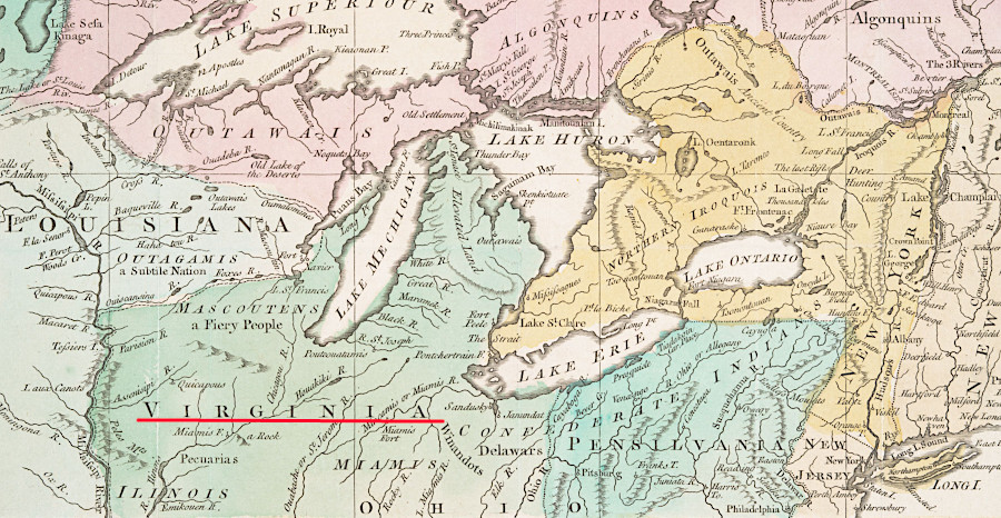
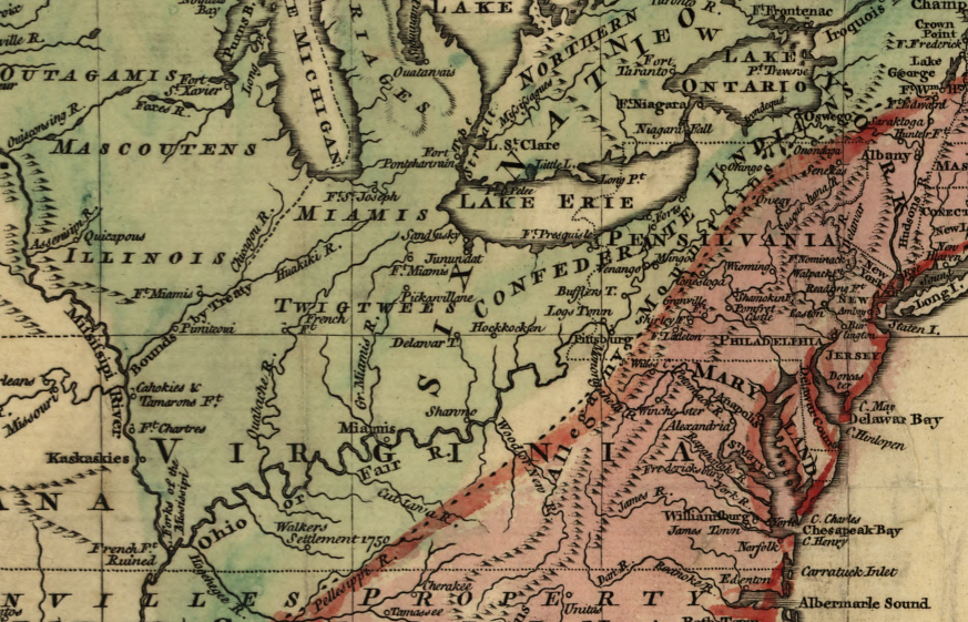
after the French and Indian War, Virginia considered lands northwest of the Ohio River to be within the colony's jurisdiction
Source: New York Public Library, An accurate map of Canada, with the adjacent countries (1761)
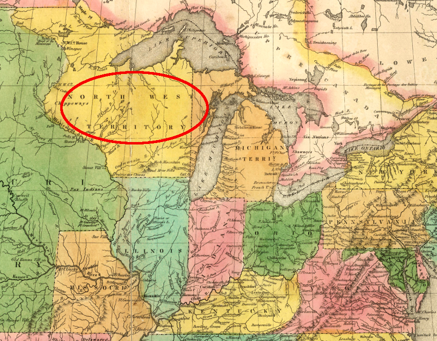
The territory ceded by Virginia was organized by the Continental Congress as the Northwest Territory, before a convention drafted a new constitution in 1787 for restructuring governance of the United States.
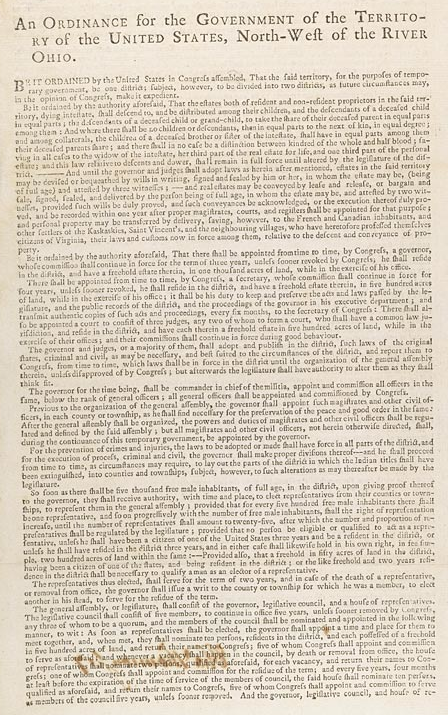
Virginia relinquished its claim to the Northwest Territory and the national government established a process to create new states, each of which was granted power equal to pre-existing states
Source: National Archives, Northwest Ordinance (1787)
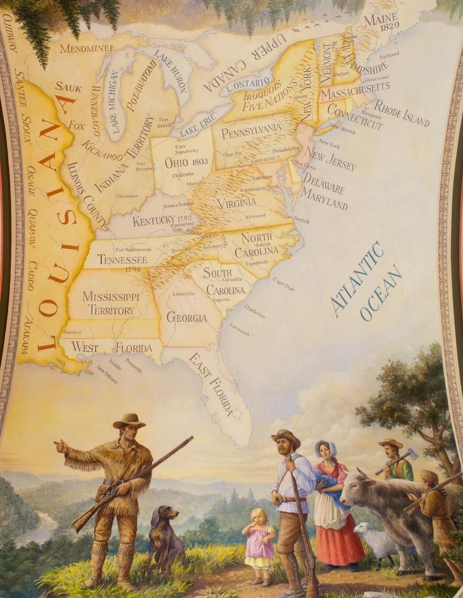
Creation of the Northwest Territory from land ceded by Virginia was followed by creation of the State of Kentucky in 1792, then the splitting off of West Virginia during the 1861-65 Civil War. In 1866 the US Congress declared that Berkeley and Jefferson counties were part of West Virginia, and in 1870 the US Supreme Court ruled that action was valid.
On the eastern boundary, Virginia's claim to the seabed of the Atlantic Ocean was eliminated by a 1947 Supreme Court decision, though the US Congress restored rights to the first three miles of the Outer Continental Shelf in the 1953 Submerged Lands Act.
Virginia's Illinois County was created in 1778, based on the conquest by George Rogers Clark and citing claims dating back to the 1609 charter, but that land was ceded to the new United States in 1783 and become the Northwest Territory when the US Congress accepted the land cession in 1784
Map Source: ESRI, ArcGIS Online
When English kings created other colonies such as Maryland and Carolina, they changed the northern and southern boundaries of Virginia. Grants to other colonies included overlapping claims to western lands. The western edge of Virginia remained unclear when King George III issued the Proclamation of 1763. That proclamation settlement in the Mississippi River watershed, where the French had relinquished their claims in the 1763 Treaty of Paris that ended the Seven Years War.
The western edge of authorized settlement was moved through negotiations with the Cherokee (1768 Treaty of Hard Labor, followed by the 1770 Treaty of Lochaber) and the Iroquois (1768 Treaty of Fort Stanwix). Those treaties opened most of the desirable land in the Ohio River watershed for colonial settlement, though Shawnee Lenape/Delaware, Mingo, and other groups disputed the authority of the Cherokee and Iroquois to authorize colonial settlement on their hunting grounds.
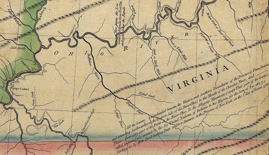
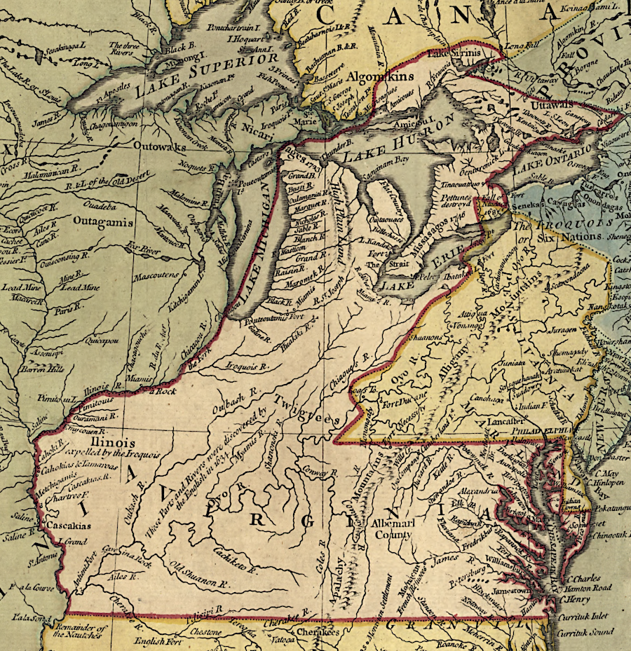
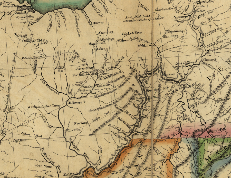
in the 1768 Treaty of Fort Stanwix, the Iroquois claimed the right to authorize colonial settlement westward to the mouth of the Tennessee ("Cherokee") River
Source: Library of Congress, A new map of the western parts of Virginia, Pennsylvania, Maryland, and North Carolina (Thomas Hutchins, 1778)
England's tacit acceptance of Virginia's western land claims ended with the 1774 Quebec Act. That bill extended the boundaries of Quebec south to the Ohio River, absorbing the Indian Territory established by the Proclamation of 1763 at the end of the French and Indian War.
The Quebec Act transferred responsibility for patenting most lands west of the Alleghenies from the restless colonies such as Virginia, Maryland, Pennsylvania, and New York to the more-loyal province of Quebec. Parliament passed the Quebec Act along with the Coercive (Intolerable) Acts, which were designed to punish the colonies after the 1773 Boston Tea Party.
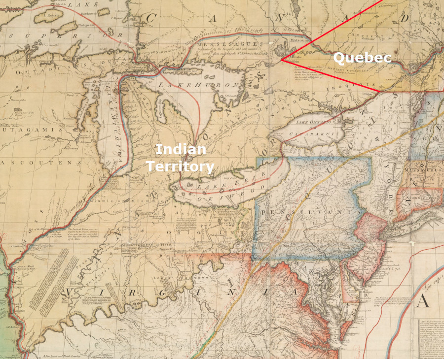
between 1763-1774, Quebec's boundaries were far north of Virginia
Source: Norman B. Leventhal Map & Education Center, Boston Public Library, A Map of the British Colonies in North America (by John Mitchell, 1775)
starting in 1774, Quebec's new boundaries blocked Virginians from the lands north of the Ohio River
Source: New York Public Library, The British colonies in North America (by William Faden, 1777)
During the Fifth Virginia Convention in 1776, Virginia leaders declared independence from Great Britain. In the first state constitution adopted by that convention in June, 1776, the new Commonwealth of Virginia blatantly ignored King George III's transfer of western lands to Quebec. The leadership of the colony of Quebec stayed loyal to King George III during the American Revolution, particularly after the American invasion in 1775-76 failed to capture the fortress at Quebec City.
The Virginians were more accommodating to the land claims of the other 12 colonies who joined the fight against Great Britain. Virginia still contested the ownership of the Forks of the Ohio, refusing to acknowledge that it fell within the boundaries of Pennsylvania, but the dispute was muted in order to coordinate the more important contest with Great Britain.
In June, 1776, the Fifth Convention adopted a constitution that defined the boundaries of the newly-independent state. Like the Proclamation of 1763, the state constitution prohibited private land purchases from Native Americans. The General Assembly was willing to abandon claims to northern and western lands to fellow state governments and the Continental Congress, but was not willing to allow speculators like Richard Henderson to claim Transylvania or the "suffering traders" to claim Indiana:2
boundaries of Virginia in 1784, after ceding northwestern land claims to the national government but before the creation of Kentucky (1792) or West Virginia (1863)
Source: NationalAtlas
In addition to Virginia, other colonies were constrained by the Proclamation of 1763. Thomas Jefferson listed a specific complaint about the Quebec Act in the Declaration of Independence, when he justified the break from King George III:3

London's efforts since 1763 to limit settlement west of the Alleghenies were cited as a justification for issuing the Declaration of Independence in 1776
Source: National Archives, Dunlap Broadside of the Declaration of Independence
the Proclamation of 1763 attempted to create an Indian Reserve and block colonial settlement on lands west of the Allegheny Mountains (shaded green), limiting Virginia's ability to issue legal title to lands granted to the Loyal Land Company, the Ohio Land Company, and others
Source: Library of Congress, A New map of North America from the latest discoveries (1763)
After declaring independence, Virginia asserted in its first constitution that the state boundaries included the vast territory west of Pennsylvania/New York and north of the 36° 30' parallel (the border with North Carolina).
if the Proclamation of 1763 could be ignored and the Virginians were entitled to all the Northwestern Territory... and Maryland too?
Source: A New and Accurate Map of North America (Carington Bowles, 1771)
In 1778, Virginia troops led by George Rogers Clark captured British forts at Kaskaskia and Vincennes. The Virginia General Assembly then created Illinois County, encompassing all the lands west of the Ohio River to the Mississippi River. Establishment of county government asserted Virginia's exclusive control over that territory, and ensured the residents would not be left "in a state of nature" with no procedures for raising militia for defense.
Military conquest of the northwest, extending to the Mississippi River, added a key element to Virginia's claim over to the land by Right of Conquest. King George III had tried to define limited western boundaries for the colonies in the Quebec Act, and Virginia troops alone had been responsible for defeating the king's claim. As viewed in Williamsburg, what the king lost... Virginia gained.
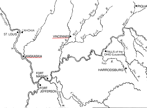
George Rogers Clark captured Kaskaskia and Vincennes during the American Revolution, cementing Virginia's claims to the territory northwest of the Ohio River
Source: National Park Service, Fort Jefferson, 1780-1781: A Summary Of Its History
Virginia's control over the territory between the Ohio River and the Great Lakes generated conflicts between states with competing land claims, and with states that had no such claims. If Virginia was allowed to sell its western lands and pocket the revenue, plus control elections and administer the area, then the other states would see Virginia's economic and political power grow at their expense. Whatever the reasons in the different colonies for declaring independence, in no case did the other 12 states relish the prospect of replacing domination from England with domination from Virginia.
A "congress" of the colonies started meeting formally in 1774. The rebellious colonies (soon to become independent states) started fighting the American Revolution together beginning with the creation of a national army on June 14, 1775. Creating a structure for a common, national government required additional years of debate and compromise. Rival colonies became rival states, and they feared domination by Virginia in whatever new form of government would be established.
Virginia was the first state to ratify the proposed Articles of Confederation in 1777. Maryland, Delaware and New Jersey delayed, demanding that states with western land claims relinquish them before creating a new national union. Maryland officials suggested Virgina was "ambitiously grasping" for territory while 13 colonies were uniting against a common enemy. In Maryland's eyes, the western lands should be treated as common property of all the states.
New Jersey asserted that any colonial right to the Northwest Territory was extinguished by the Proclamation of 1763 and the Quebec Act of 1774. The victories by George Rogers Clark in 1778-1779 should be viewed as conquest of the territory in the name of the Continental Congress, not for just Virginia.
Over half of the states participating in the Continental Congress (MA, CT, NY, VA, NC, SC, and GA) had charters with no fixed boundary on their western edge, or cited other authorities to justify overlapping claims to the some of the same territory claimed by Virginia.
The other six states (NH, RI, NJ, PA, DE, and MD) had no justification to assert authority over western lands, but still had great interest regarding how that land would be sold, settled, and administered. Those six states feared that in the future, as population grew, the landlocked states would lose power and influence as the other states expanded.
after the American-French victory at Yorktown in 1781, negotiators considered various proposals for a western boundary before signing the Treaty of Paris in 1783
Source: University of Connecticut, MAGIC Historical Map Collection, Part XXV of Historical Atlas of Modern Europe from the Decline of the Roman Empire:
The ultimate solution was to have the all the states establish a clear territorial line on their western borders, to give land claims west of those borders to the new national government, and to create new states from that public domain. That solution limited the future growth of the seven states with land claims, while income from land sales in the new national territory could be used to pay off the national government's debts from the Revolutionary War. The new public domain also provided a way for the Congress to honor land grants promised as bounties for serving in the Continental Army.
Virginia's land borders were modified between the 1632 creation of Maryland (yellow) and the 1870 Supreme Court ruling that Berkeley and Jefferson counties (red) were legally added to West Virginia by Congressional action in 1866
Source: Franklin K. Van Zandt, Boundaries of the United States and the Several States, Geological Survey Professional Paper 1212 (p.144)
Legislators in the General Assembly knew that most trade in the region would be via boats going down the Ohio and Mississippi rivers to New Orleans, rather than to Virginia's ports on the Chesapeake Bay. Virginia's leaders were willing to transfer the state's claims to the national government, and did not plan to retain political control permanently over lands northwest of the Ohio River.
Affirming the claims of Maryland/Pennsylvania to the boundaries defined in charters to Calvert and Penn, plus agreeing to create new states from lands northwest of the Ohio River, would reduce interstate conflicts. Though it had been hard to capture Kaskaskia and Vincennes, it would be even harder to govern them from Richmond.
Congress encouraged Virginia's land cessions. Creating a public domain, a vast stretch of land controlled by a united national government rather than having separate states retain control over lands stretching to the Mississippi River, would tighten the bonds between Virginia and the other 12 breakaway colonies and would focus colonial efforts on winning independence from Great Britain.
land claims of multiple states complicated efforts of Congress to establish consistent policy with Native Americans living west of the Ohio River and Allegheny Front
Source: Library of Congress, "Robertson's geographic-historical series illustrating the history of America and the United States: from 1492 to the present time," The thirteen original states, 1783
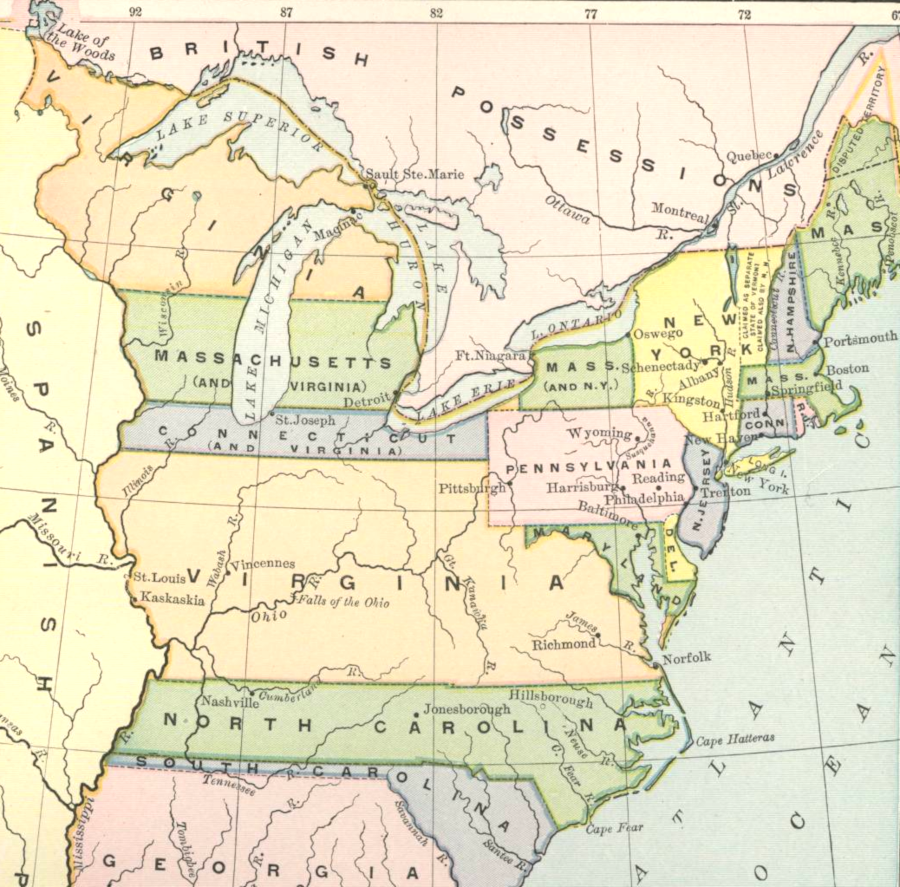
Massachusetts and Connecticut asserted claims to the Northwest Territory based on colonial charters
Source: Agathon Associates, Epochs of American History: Formation of the Union 1750-1829 (by Albert Bushnell Hart, 1926)
Arranging the land cession involved complicated politics. After Delaware ratified the Articles of Confederation on February 1, 1779, Maryland was left as the last holdout.4
Virginia reacted to the delay by opening a land office in 1779. It started to sell western lands to raise revenue, and issued patents for land based on old military warrants issued for service in the French and Indian War.
In response, the Continental Congress called for all states to freeze their land sales:5
Virginia's General Assembly objected strongly to interference by the nascent national government in the independent state's internal affairs. The legislature issued a "remonstrance" on December 14, 1779:6
As described in the Madison Papers at the National Archives:7
Maryland's resistance postponed adoption of the Articles of Confederation for three years, until 1781.
New York led the land cession process by example on January 17, 1780. It abandoned its flimsy claim that treaties with the Six Nations had conveyed the land claims of the Iroquois, obtained by right of conquest, to territory southwest of Lake Ontario. New York authorized its delegates to the Continental Congress to transfer the state's rights (if any...) to lands outside of its established boundaries.
New York based its claim over western lands on conquest of the Iroquois
Source: David Rumsey Historical Map Collection, The English and French Settlements in Nth America. (by Emanuel Bowen and John Gibson, 1758)
Congress then finessed the issue over national vs. state authority by simply asking the other states to mimic New York. On October 10, 1780, when the outcome of the American Revolution was still in doubt, the Continental Congress declared that whatever land was ceded to the new nation after the anticipated defeat of Great Britain "shall be disposed of for the common benefit of the United States." Virginia would not be allowed to dominate the new nation by its control of the vast territory which it claimed.
Virginia's legislature relinquished its land claims on January 2, 1781. The British Army had invaded in 1780 and created a base at Portsmouth. Virginia's militia was unable to offer effective resistance, and the invasion made clear to the General Assembly that it needed support from the other states. French officials were also encouraging adoption of the Articles of Confederation in order to formalize the national government.
Virginia imposed eight conditions that included requirements for the Congress to:8
Those conditions would validate property ownership of Virginia speculators, but eliminate the potential value of various land companies chartered outside of Virginia. In particular, those conditions blocked land claims of the Transylvania colony proposed by Judge Richard Henderson and ensured Virginia's claim of authority over Kentucky. The "land jobbers" (speculators) in Pennsylvania strongly objected, since the Virginia requirements would cancel the land claims of the Illinois-Wabash, Vandalia, and Indiana companies.
Virginia included in its January 2, 1781 legislation that:9
Maryland finally signed the Articles of Confederation on March 1, 1781. The 13 separate states officially became one nation. Under the Articles of Confederation, the United states was a loose alliance of 13 separate states who retained almost all legal authority. The national government had no authorization to impose taxes. It was dependent upon the 13 states to voluntarily provide the massive amount of funding required to pay off loans arranged to cover costs of the American Revolution.
A series of raids by the British navy and privateers throughout the Chesapeake region in 1780 had spurred Maryland as well as Virginia to compromise. When Maryland asked the French to provide ships to block the raids, the French responded with a suggestion that Maryland should first ratify the Articles of Confederation. Maryland acted slightly more than six months before Lord Cornwallis surrendered at Yorktown. At the time of ratification the military outcome of the war was still very much in doubt; the national government would be eliminated if the British won a military victory and restored royal control.
The Maryland legislature included in its 1781 ratification approval:10
Virginia renewed its cession offer on October 20, 1783, and dropped the condition defined in 1781 that the national government guarantee the state borders. The change finessed the previous requirement that the 12 other states acknowledge Virginia's authority over Kentucky. It also dropped the requirement that the claims to land by Illinois-Wabash, Vandalia, and Indiana companies be voided. As a result of lobbying by the land companies, Maryland had championed their claims and blocked the Congress from accepting Virginia's cession with eight conditions.
New England states supported the land speculator claims. They partnered with the "landless states" with no charter rights to western lands, seeking support for admitting Vermont into the Congress and increasing representation from the New England region. After a committee of the Congress recommended forcing Virginia to drop its requirement to void the land company claims, Virginia's representatives insisted that no vote be held until the members of Congress publicly announced if they had an economic interest in the land companies.
In 1782, the Congress accepted to cession of western land claims from New York. Based on the claim that the Iroquois had ceded their control of western lands to New York, a cession from Virginia was not needed. However, Virginians had effective control of the lands in dispute. Frustrated by the machinations in the Congress, the General Assembly considered rescinding its offer of the western lands.
By 1783 the priority of the Congress shifted towards generating revenue for the national government through sale of the western lands. There was also strong pressure from veterans to get paid and to be given the promised land bounties. To sell or grant land to veterans, the Congress had to clear title by eliminating the claims of Virginia. A new committee report created artful language which was acceptable to Virginia, while enabling the Congress to decide later on whether to give the land speculators some or all of what they requested.
The Virginia General Assembly approved new legislation authoring the cession of land north and west of the Ohio River on December 20, 1783. Congress accepted Virginia's new cession offer on March 1, 1784. Acceptance came only after a Pennsylvania delegate changed his vote. He may have been influenced by Thomas Jefferson's support for blocking Connecticut from reopening its claim to the Wyoming Valley in Pennsylvania.
Virginia's delegates, Thomas Jefferson, Samuel Hardy, Arthur Lee and James Monroe, then signed the Deed of Cesssion.11
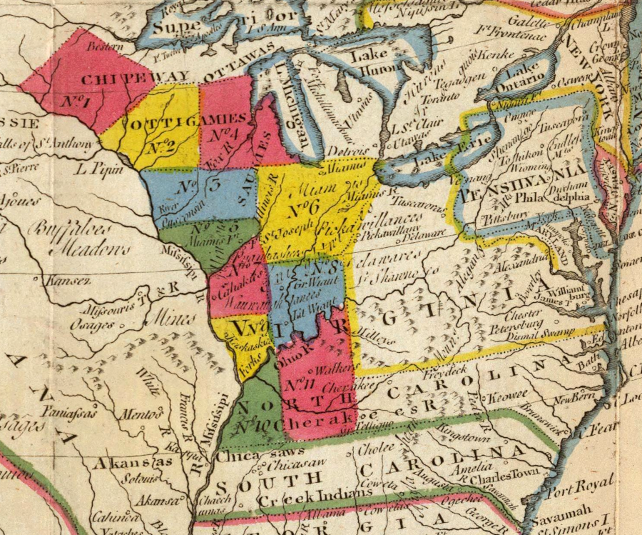
Massachusetts and Connecticut, like Virginia, had charters that established land claims extending into the Ohio Country
Source: Bureau of Land Management, A History of the Rectangular Survey System
A remaining complication: the Congress rejected the Virginia conditions, as established on January 2, 1781. Virginia's land cessions were not accepted immediately. The treaty of Paris between the United States and England in 1783 established the Mississippi River as the western edge of the new nation, but debate regarding state land claims west of the Ohio River continued until 1784.
treaty negotiators in Paris ending the American Revolution in 1783 did not project state boundaries into the western lands of the new United States of America
Source: National Archives, An Accurate Map of the United States of America, with Part of the Surrounding Provinces agreeable to the Treaty of Peace of 1783
In the two years of further discussion, land speculators and other states sought to gain control of the Virginia lands between the Proclamation Line of 1763 and the Ohio River. Massachusetts and New York relinquished their western land claims, but Connecticut succeeded in acquiring land.
Connecticut claimed land in what became Pennsylvania and then the Northwest Territory based on similar "sea to sea" language its 1662 colonial charter. The claim to the Wyoming Valley in Pennsylvania was rejected in 1782 by a national court created under the Articles of Confederation. On September 14, 1786, Connecticut ceded its western land claims to the Continental Congress but reserved rights to a 50-mile wide strip that was roughly equal in acreage to the Wyoming Valley.
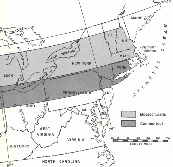
Connecticut managed to obtain rights to sell the lands within its Western Reserve, which was established by the 1787 Northwest Ordinance when lands west of the Ohio River were organized by the Continental Congress. Running east-west, the strip extended 120 miles from the Pennsylvania boundary. In the north-south direction, the strip ran between 41° and 42° 2' north latitude. Much of the northern portion of the Western Reserve is in Lake Erie, but there were nearly 3.4 million acres of land reserved by Connecticut.
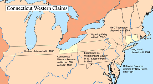
Connecticut, like Virginia, managed to reserve lands in the Northwest Territory
Source: Wikipedia, Connecticut Western Reserve
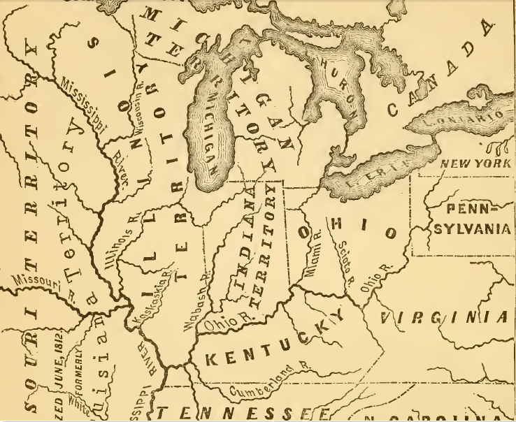
Connecticut also claimed the right to govern the Western Reserve separately from the Federal control over the Northwest Territory. Confusion regarding who had the power to make decisions ended when the US Congress passed the Quieting Act in 1800. Ohio became an independent state in 1803, with full authority to govern the Western Reserve as well as the Virginia Military District.
In March 1784, Thomas Jefferson wrote to George Washington on the urgency of Virginia improving its transportation network westward from the Potomac River to the Ohio River, so Virginia rather than New York would capture the future trade between the "Northwest" and ports on the Atlantic coast. In that letter, he justified why Virginia should retain western lands to the Ohio River, especially the Kanawha River watershed, but allow new states to be formed from lands beyond the Ohio River:12
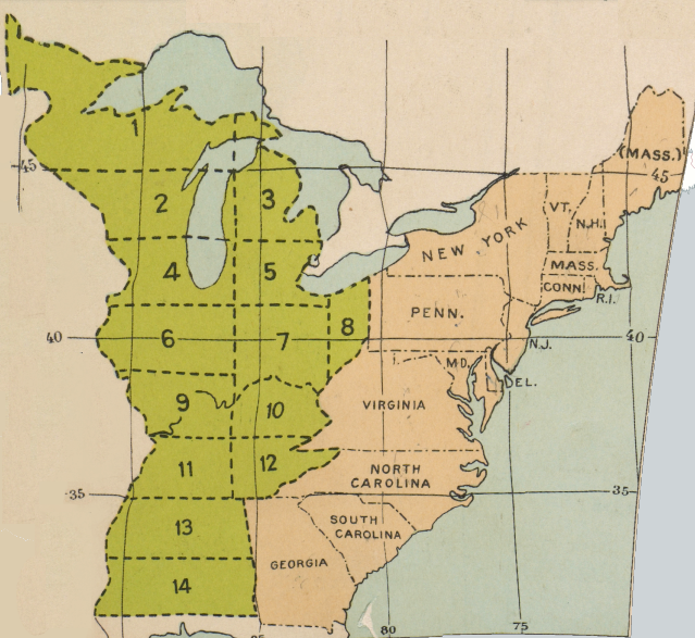
Thomas Jefferson proposed creating 14 small states from the Northwest Territory
Source: David Rumsey Historical Map Collection, Proposed States According to Ordinance of 1784 (Plate 46b, digitized by University of Richmond)
new states in the Northwest Territory would have been rectangular, if Thomas Jefferson's ideas had been adopted
Source: Atlas of the Historical Geography of the United States, A New Map of North America, From the Latest Discoveries. 1778 (Jonathan Carver, 1781)
Virginians played a major role in shaping the management of the new Northwest Territory. Through the Land Ordinance of 1785, Thomas Jefferson proposed the system by which lands would be surveyed before sale, using what evolved into the Public Land Survey System. He would play an even greater role in acquiring Federal territory west of the Mississippi River, through the Louisiana Purchase.
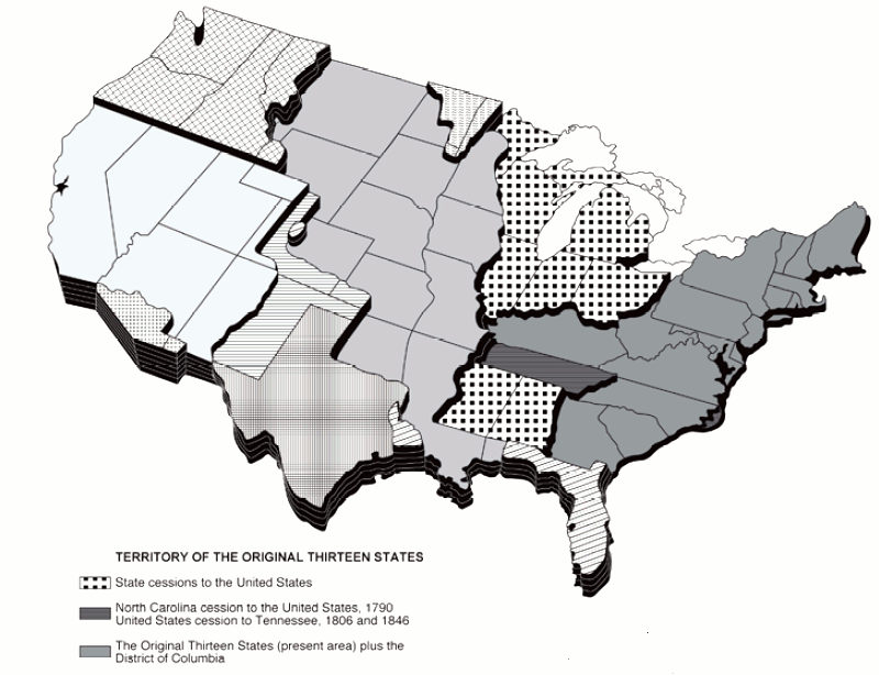
cessions by states to the national government
(after North Carolina's military grants were claimed in Tennessee, so little land was left in the public domain that Congress gave the state all rights to sell the remainder)
Source: Bureau of Land Management Public Land Statistics
the Northwest Territory was reduced in size as new states were created from it
Source: David Rumsey Historical Map Collection, United States of America (by Mathew Carey and M. Lavoisne, 1820)
The Land Ordinance of 1785 defined how the new public domain of the national government would be sold. Rectangular blocks of land were defined before it land was offered for sale. Starting at the western edge of Pennsylvania and going westward, north-south lines called "ranges" were to be surveyed six mile apart. Starting at a point on the Ohio River, east-west lines were to be surveyed every six miles going north. The most southern east-west line was called the Base Line, or the Geographer's Line.
The intersecting lines created six mile squares called townships. Most were to be further subdivided into 36 sections, each a square mile (640 acres) in area. Section 16, one square mile in every 36-square mile township, was reserved for education. States were authorized to sell the 640 acres and use the revenue for schools.
Within a 36-square mile township, the 36 sections were numbered in a regular pattern. The pattern of numbering the sections within a township was repeated in all the townships. Each section (Section 1, Section 2, Section 3 through Section 36) was distinct because it was also labelled with the numbering of the township and range:13
initial surveys in Ohio under the Northwest Land Ordinance of 1785 placed Section 1 in the township's southeast corner
Source: US Geological Survey (USGS), National Map Viewer
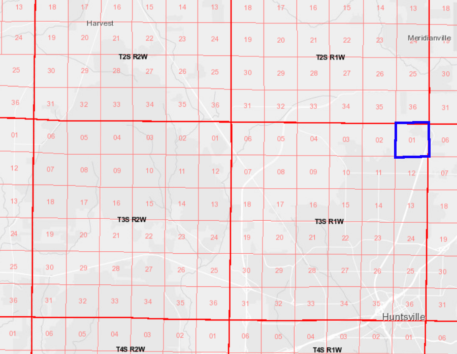
townships, ranges and sections in Alabama are numbered according to the sequence established in the Land Act of 1796, with Section 1 in the northeast corner
Source: US Geological Survey (USGS), National Map Viewer
Requiring land surveys to be completed before land sales, establishing clear property boundaries first, eliminated most of the land ownership confusion that Thommas Jefferson experienced in Virginia where parcels would be claimed first and boundaries were surveyed later. Selling land defined by a rectangular system prevented claimants from drawing boundaries based on metes and bounds surveys that included only the best land and omitted low-value territory.
That 1785 law protected one remaining claim of Virginia to lands northwest of the Ohio River.
Virginia had set aside lands in Kentucky for soldiers and sailors who had served in the state or national forces during the American Revolution - one incentive to enlist or remain in the military was the potential value of the land grants. Virginia was concerned that the designated Kentucky lands on the Cumberland River, between the Green and Tennessee, would not be sufficient to redeem all bounties issued for enlisting.
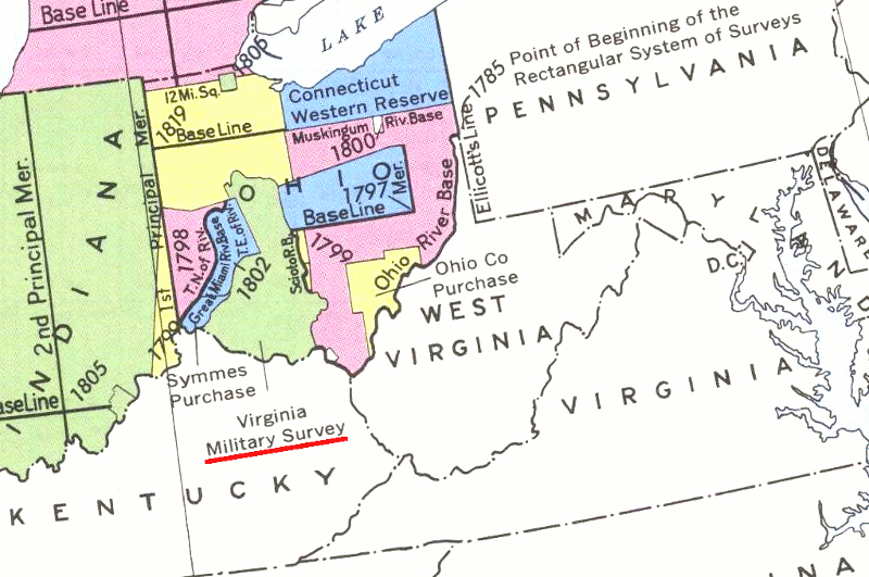
survey of Virginia Military Reserve between Scioto River and Little Miami River
Source: Bureau of Land Management, Principal Meridians and Base Lines
Just in case, Virginia's cession to the Congress identified a 4.2 million acre Virginia Military Reserve in Ohio, where those who had served in Virginia's military forces during the American Revolution (and those who had purchased the land rights from the soldiers and officers...) could claim their property:14
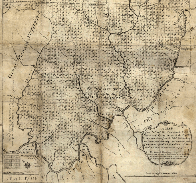
Public Land Survey System rectangular boundaries east of Virginia Military District (district was located west of Scioto River, and surveyed according to traditional metes and bounds descriptions)
Source: Library of Congress, A map of the Federal Territory from the western boundary of Pennsylvania to the Scioto River
laid down from the latest informations and divided into townships and fractional parts of townships agreeably to the ordinance of the honle. congress passed in May 1785
The Virginia Military District in Ohio (like a similar district in Kentucky) was surveyed using the traditional metes and bounds technique, not the rectangular surveys established in the Land Ordinance of 1785:15
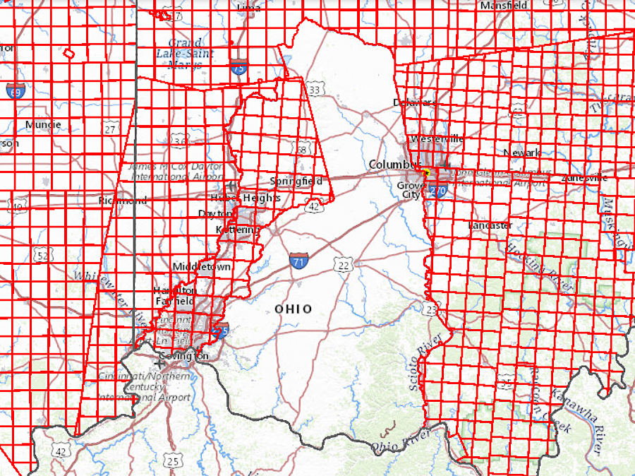
the rectangular survey system was not applied in the Virginia Military District
Source: US Geological Survey (USGS), National Map Viewer
The Congress established under the Articles of Confederation accepted the cession of western lands claimed by the separate states. The Confederation Congress passed the Northwest Ordinance on July 13, 1787 to provide a government for the territory. That act authorized the Congress to appoint a governor and judges, established that residents could elect a territorial legislature once the population reached 5,000 free male inhabitants of full age.
Two key policy decisions were incorporated in the Northwest Ordinance of 1787. The Congress determined that three-five new states would be created and admitted to the Union on an equal footing with the original 13 states. The ordinance also stated:16
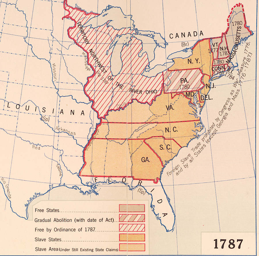
the Northwest Ordinance of 1787 prohibited slavery in the territory ceded by Virginia and other states
Source: Library of Congress, Slavery, 1850-1865 (Hart-Bolton American history maps, 1919)
The authority of the Confederation Congress to claim it could govern the Northwest Territory was questionable. The limited powers granted to the national government in the Articles of Confederation had not anticipated the need to create a new form of government to replace state authority over the western lands. If the national government had such power, the Congress might assert unlimited control over one or more individual states.
James Madison suggested in Federalist #38 that ratification of the proposed Constitution written in 1787 was required to check the unfettered authority being assumed by the Continental Congress. He anticipated that revenue from the new western lands could be used inappropriately unless the constraints in the proposed Constitution were applied:17
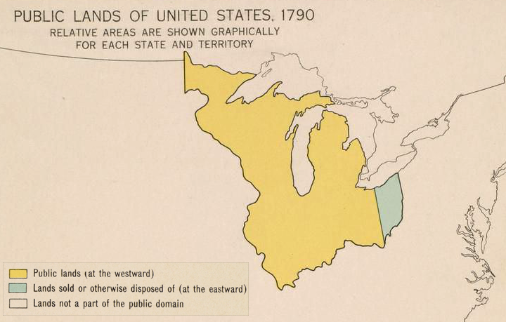
the US Government surveyed and sold the lands in the Northwest Territory, starting with eastern Ohio
Source: Atlas of the Historical Geography of the United States, Public Lands of the United States, 1790 (Plate 57a, digitized by Digital Scholarship Lab, University of Richmond)
The US Supreme Court echoed Madison's perspective that the Confederation Congress lacked authority, under the Articles of Confederation, to accept the land cessions by the states. The 1857 Dred Scott v. Sandford decision stated that the:18
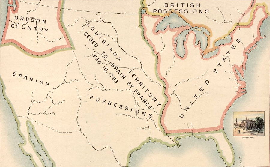
the Spanish controlled the Louisiana Territory west of the Northwest Territory until its purchase in 1803, after Thomas Jefferson stretched his interpretation of the US Constitution
Source: Library of Congress, "Robertson's geographic-historical series illustrating the history of America and the United States: from 1492 to the present time," United States after Sept. 3. 1783
the Northwest Territory in 1778, without any land claims on the map
Source: Library of Congress, A new map of the western parts of Virginia, Pennsylvania, Maryland, and North Carolina (Thomas Hutchins, 1778)
the Northwest Territory in 1784, showing Connecticut's land claims
Source: Library of Congress, Mapping a New Nation: Abel Buell's Map of the United States, 1784 (Abel Buell, 1784)
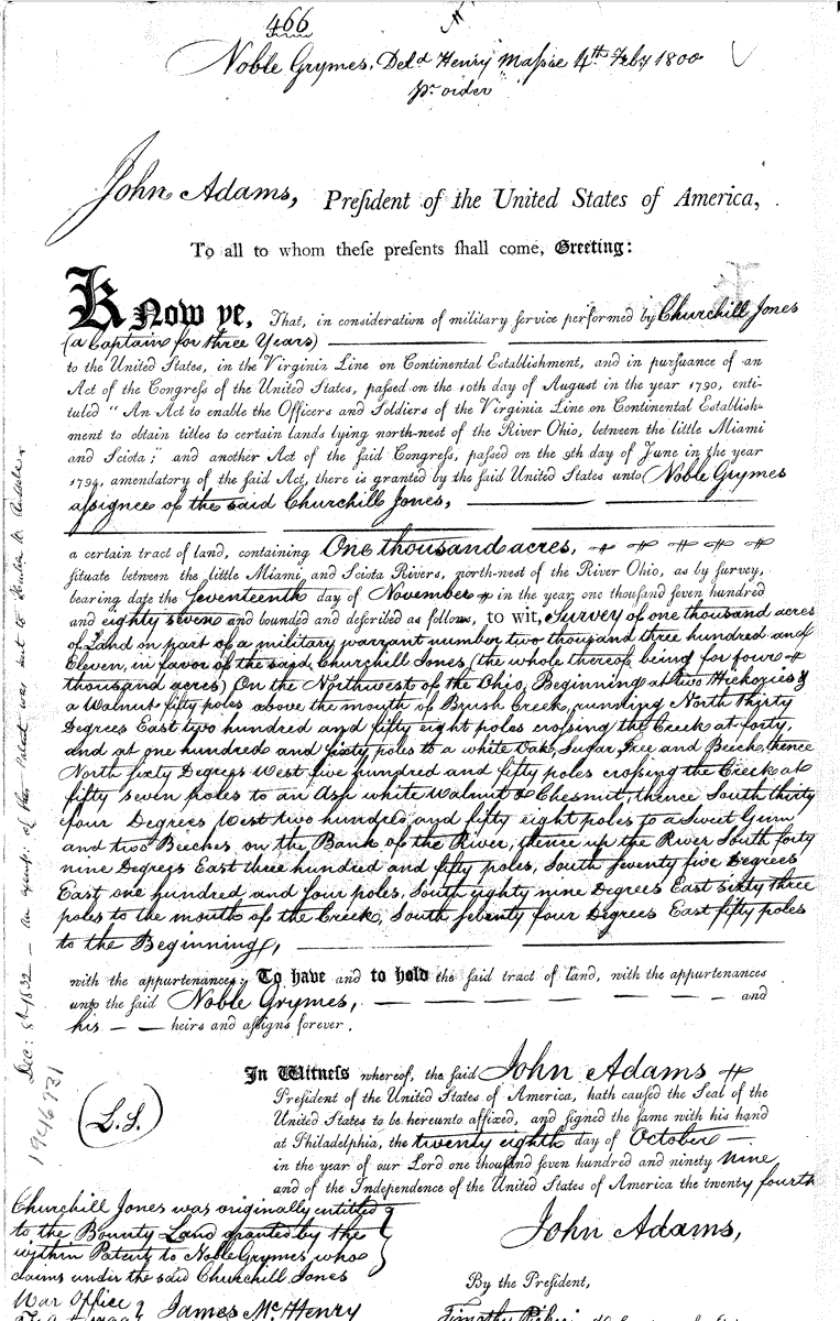
grant of land in Virginia Military District for service in the Virginia Line of the Continental Army
Source: Bureau of Land Management, Official Federal Land Records Site
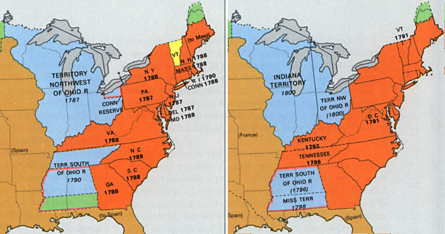
Kentucky and Tennessee were the first two states created from western lands ceded by the states to the new US Congress, and Ohio was the third
Source: Library of Congress, "The National Atlas of the United States of America," Territorial Growth
Virginia never offered to cede Kentucky to the national government; settlers had quickly recognized it as valuable farmland
Source: Library of Congress, A new map of the western parts of Virginia, Pennsylvania, Maryland, and North Carolina (by Thomas Hutchins, 1778)
the Northwest Territory was carved into territories and states after Virginia's cession
Source: Internet Archive, A School History of the United States, from the Discovery of America to the Year 1878 (p.250)
the Confederation Congress determined that western lands would be admitted as states on an equal basis with the original 13, ensuring "a more perfect union" rather than creating a secondary, perpetually-colonial status for westerners
Source: Architect of the Capitol, From the Atlantic Ocean to the Mississippi River