Illinois County
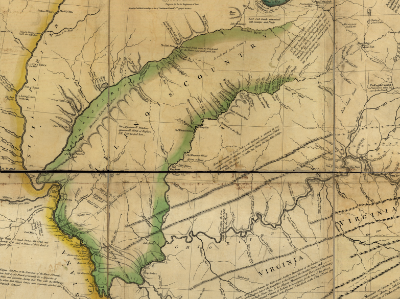
Virginia's claim to the Illinois Country was based on conquest by George Rogers Clark during the American Revolution, plus the Second Charter of 1609
Source: Library of Congress, A new map of the western parts of Virginia, Pennsylvania, Maryland, and North Carolina (Thomas Hutchins, 1778)
The land northwest of the Ohio River and stretching to the Mississippi River was not organized as part of any Virginia county until 1735. Illinois County was not created until 1778. The Virginia-based local government lasted only six years. Illinois County was extinguished when Virginia ceded its claims to the Northwest territory to the United States in 1784.
Virginia's legal claim to the Illinois country dated back to its Second Charter, issued in 1609, when King James I granted the Virginia Company of London control over inland territory all the way to the Pacific Ocean:1
- ...all that Space and Circuit of Land, lying from the Sea Coast of the Precinct aforesaid, up into the Land throughout from Sea to Sea, West and Northwest
In 1609, no one in Europe or North America had a clue how much land was included within that grant. Officials in England knew that the land King James I granted to the Virginia Company investors was already occupied by Native Americans, but did not acknowledge that they had land ownership rights. The English knew that aboriginal residents had to be displaced, but assumed that the legal rights to the land started with royal grants rather than pre-existing possession of territory.2
The French presence allowed them to claim authority over lands in the Ohio and Mississippi River watersheds by "Right of Discovery." The English based in Virginia were slower to reach the Ohio River valley and the Mississippi River and had to rely upon "Right of Conquest" to claim the land. The United States of America eliminated Great Britain's claim to territory east of the Mississippi River and south of modern-day Canada through negotiations that ended the American Revolution with the Treaty of Paris in 1783.
John Lederer was the first English colonist to document land west of the Blue Ridge in 1669. Franz Ludwig Michel explored and mapped the Shenandoah River in 1706. A variety of Virginia and Pennsylvania traders gradually established connections with different Native American tribes west of the Ohio River, often without official sanction. Establishment of government authority over the territory came gradually.
In 1716, Governor Spotswood organized the Knights of the Golden Horseshoe to explore across the Blue Ridge. He then helped to negotiate the 1722 Treaty of Albany in which the Haudenosaunee (Iroquois or Six Nations, including the Tuscarora after 1722) agreed to stay to west of the Blue Ridge.
The Haudenosaunee relinquished claims to lands further west in the 1744 Treaty of Lancaster and the 1768 Treaty of Fort Stanwix. The English uncritically accepted the Haudenosaunee claim that they had the right to cede those lands. The English chose to believe that the Haudenosaunee had defeated the Native American groups who lived on those lands, and thus held title. The Delaware, Mingo, and Shawnee in particular did not accept the authority of the Six Nations.
In 1735, colonial officials in Williamsburg disputed the boundaries of the Fairfax Grant on the Northern Neck. The General Assembly of Virginia finally started to create local governments west of the Blue Ridge. It divided Spotsylvania County to create Orange County on its western edge, defining the county's boundaries to include:3
- ...all that territory of land... bounded southerly by the line of Hanover County, northerly by the grant of the Lord Fairfax, and westerly by the utmost limits of Virginia.
There were plenty of Native Americans living in the defined area, but none were consulted or compensated. No Native Americans considered Williamsburg to be the location of their leaders.
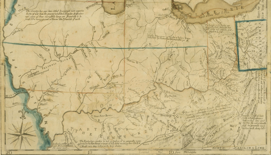
the Illinois Country in 1785
Source: John Carter Brown Library at Brown University, A map of the north west parts of the United States of America (John Fitch, 1785)
Starting in 1738, Orange County's land west of the Blue Ridge was designated as Augusta and Frederick counties. As settlers moved west of the Blue Ridge and then the Appalachian mountains, the governor appointed members of the county courts and they began to meet. Frederick County was organized and the county court began to meet in 1743. Settlers took a little longer to migrate further south into Augusta County, and started two years later in 1745.
Augusta County's western edge was undefined, "extending from thence northerly, westerly, and southerly, beyond the said mountains, to the utmost limits of Virginia."
The Treaty of Aix-la-Chapelle in 1748 had ended the War of Austrian Succession in Europe and King George's War in North America, but that treaty did not define control of the Ohio River Valley. France claimed the Ohio River watershed by Right of Discovery; England claimed the same land through treaties negotiated with the Haudenosaunee in New York. Negotiators for the 1748 treaty chose not to try to resolve the dispute.
Despite the unclear title, land speculators based in Virginis started to obtain large land grants in the Ohio River watershed. The Ohio Company and the Loyal Land Company obtained charters in 1749 to survey and claim hundreds of thousands of acres. British officials dealt with the Cherokee and Haudenosaunee, assuming they had the capacity to dominate and speak for other tribes.
Left on the sidelines during the decisionmaking process were the Delaware, Shawnee, Wyandot, Miami, and other Native American nations who lived and hunted on that territory. If Europeans had applied the Right of Possession concept, the occupants had legal claims to the land and were entitled to compensation. Instead, they had to go to war and then, after being defeated, obtain whatever trade goods the British would offer to smooth the deal.
After the British conquered Quebec and Montreal, the French forts on the Great Lakes and in the Mississippi River watershed were included in the surrender. British troops took control of Detroit, Vincennes, Kaskaskia, and other French settlements in 1760.
The 1763 Treaty of Paris, which ended the French and Indian War (known as the Seven Years War in Europe), defined the western boundary of the English claims in North America at the Mississippi River. West of the river, Spain was given the land previously claimed by France. In 1763 France was expelled from North America except for two small islands near the mouth of the St. Lawrence River. Those islands were used to support the French fishing fleet.4
The oversized Augusta County was gradually reduced by the creation of new jurisdictions. The District of West Augusta was carved out in 1774, but "counties" were not created then to avoid violating the prohibitions in the Proclamation of 1763. After Virginia chose to declare independence in 1776, the General Assembly created Monongalia, Yohogania and Ohio counties from that district. By 1776, British officials could no longer issue orders to Virginia's leaders.
In 1778, George Rogers Clark seized control of British forts on the Wabash and Mississippi Rivers at Vincennes, Cahokia, and Kaskaskia. The French inhabitants of the area declared their allegiance to Virginia, largely because Clark ensured their property would not be seized. He promised they would not be disturbed in their customs, which was significant since the French were Roman Catholics. It also helped that France had allied with the United States against Great Britain.
The General Assembly responded in December 1778 by creating Illinois County, promising religious freedom to the inhabitants:5
- WHEREAS by a successful expedition carried on by the Virginia militia, on the western side of the Ohio river, several of the British posts within the territory of this commonwealth, in the country adjacent to the river Mississippi, have been reduced, and the inhabitants have acknowledged themselves citizens thereof, and taken the oath of fidelity to the same, and the good faith and safety of the commonwealth require that the said citizens should be supported and protected by speedy and effectual reinforcements, which will be the best means of preventing the inroads and depredations of the Indians upon the inhabitants to the westward of the Allegheny mountains; and whereas, from their remote situation, it may at this time be difficult, if not impracticable, to govern them by the present laws of this commonwealth, until proper information, by intercourse with their fellow citizens, on the east side of the Ohio, shall have familiarised them to the same, and it is therefore expedient that some temporary form of government, adapted to their circumstances, should in the mean time be established.
- Be it enacted by the General Assembly, That all the citizens of this commonwealth who are already settled, or shall hereafter settle, on the western side of the Ohio aforesaid, shall be included in a distinct county, which shall be called Ilinois county...
Virginians retained their claim to that territory until 1784, when the Northwest Territory was ceded to the US Congress. Illinois county existed between December 9, 1778 - March 1, 1784.6
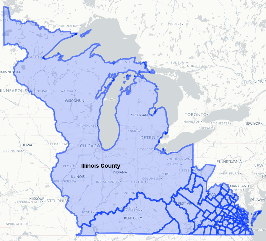
Illinois County, Virginia, existed from 1778-1784
Source: Newberry Library, Atlas of Historical County Boundaries
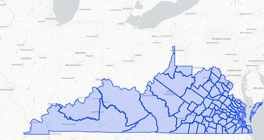
Illinois County was abolished in 1784, and the US Congress gained control over the Northwest Territory
Source: Newberry Library, Atlas of Historical County Boundaries
Links
- National Archives
- Newberry Library
- Virginia Legislative Information System
References
1. "The Second Charter of Virginia; May 23, 1609," The Avalon Project, Yale Law School, http://avalon.law.yale.edu/17th_century/va02.asp (last checked April 5, 2016)
2. "Expedition of Marquette and Joliet, 1673," Wisconsin Historical Society, https://www.wisconsinhistory.org/Records/Article/CS520; "René Robert Cavelier, Sieur de La Salle: Life and Explorations," Texas Historical Society, August 3, 2020, https://www.tshaonline.org/handbook/entries/la-salle-rene-robert-cavelier-sieur-de; "The Founding of New Orleans," American Battlefield Trust, https://www.battlefields.org/learn/articles/founding-new-orleans (last checked May 27, 2025)
3. William Wallace Scott, A History of Orange County, Virginia: From Its Formation in 1734 (O.S.) to the End of Reconstruction in 1870, Genealogical Publishing Company, 1974, p.23, https://books.google.com/books?id=H-_gXS8qit8C (last checked April 8, 2016)
4. "An Act, for erecting two new Counties, and Parishes; and granting certain encouragements to the Inhabitants thereof," Hening's
Statutes at Large, Chapter XXI, http://vagenweb.org/hening/vol05-05.htm; "Treaty of Paris, 1763," US Department of State, https://history.state.gov/milestones/1750-1775/treaty-of-paris (last checked January 18, 2021)
5. "An act for establishing the county of Ilinois, and for the more effectual protection and defence thereof," Hening's
Statutes at Large, Chapter XXI, http://vagenweb.org/hening/vol09-25.htm#page_552 (last checked January 18, 2021)
6. "Virginia: Individual County and Independent City Chronologies," Atlas of Historical County Boundaries, Newberry Library, https://publications.newberry.org/ahcb/documents/VA_Individual_County_Chronologies.htm#Individual_County_Chronologies (last checked July 12, 2025)
Virginia Counties
Virginia Places